The Six Waterfalls Hike

Hiking / TrekkingWaterfallsSwimmingCaveBird-Watching

Pahnairlap Waterfall, Pohnpei, Federated States of Micronesia (FSM)
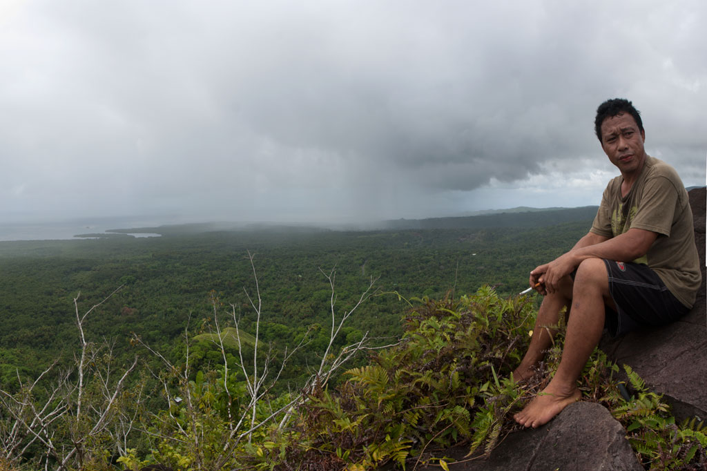
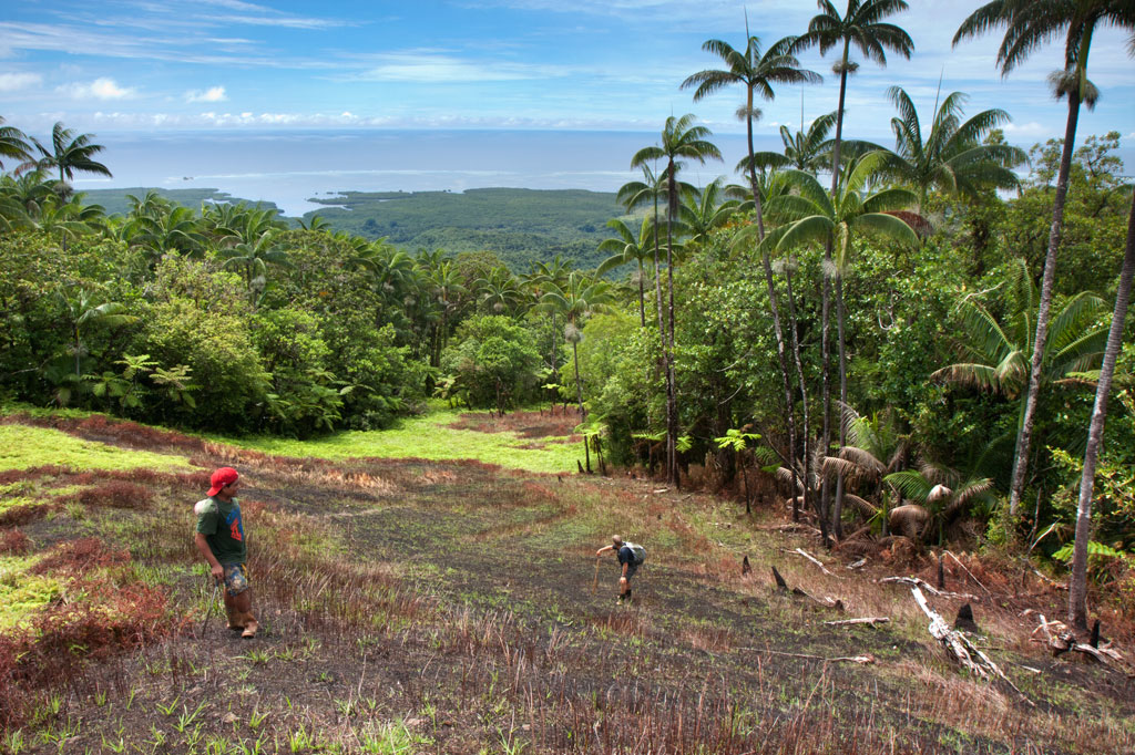
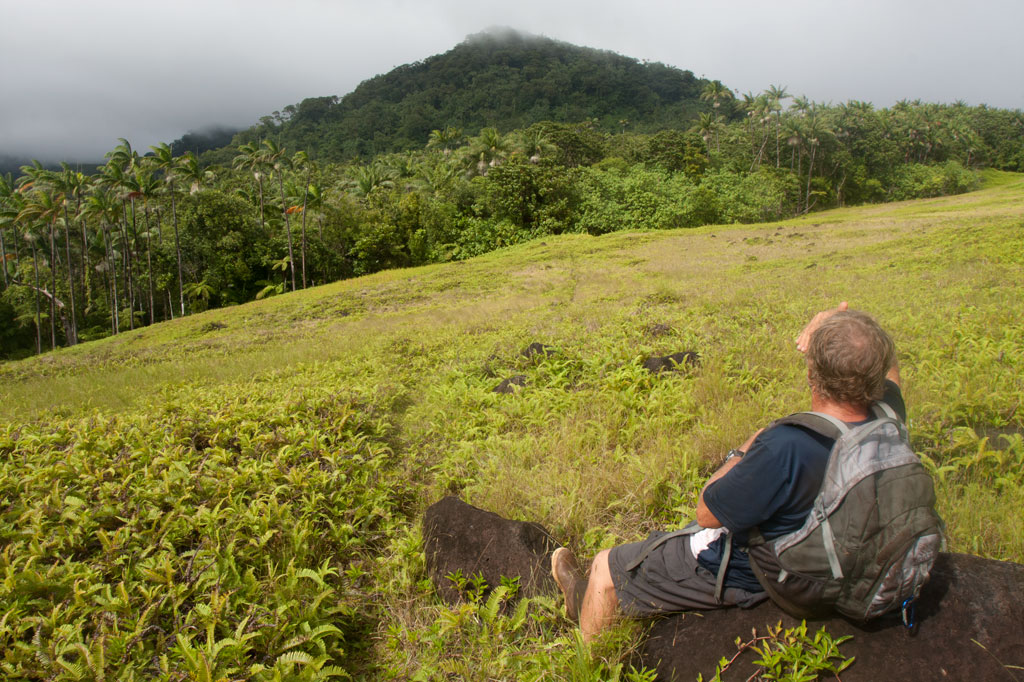
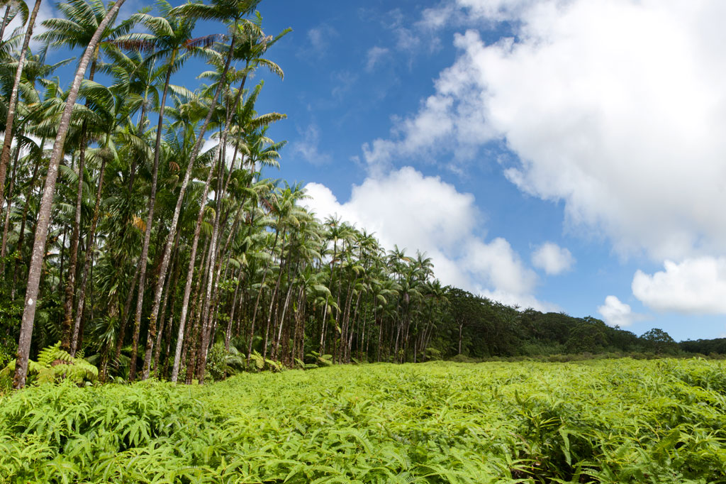
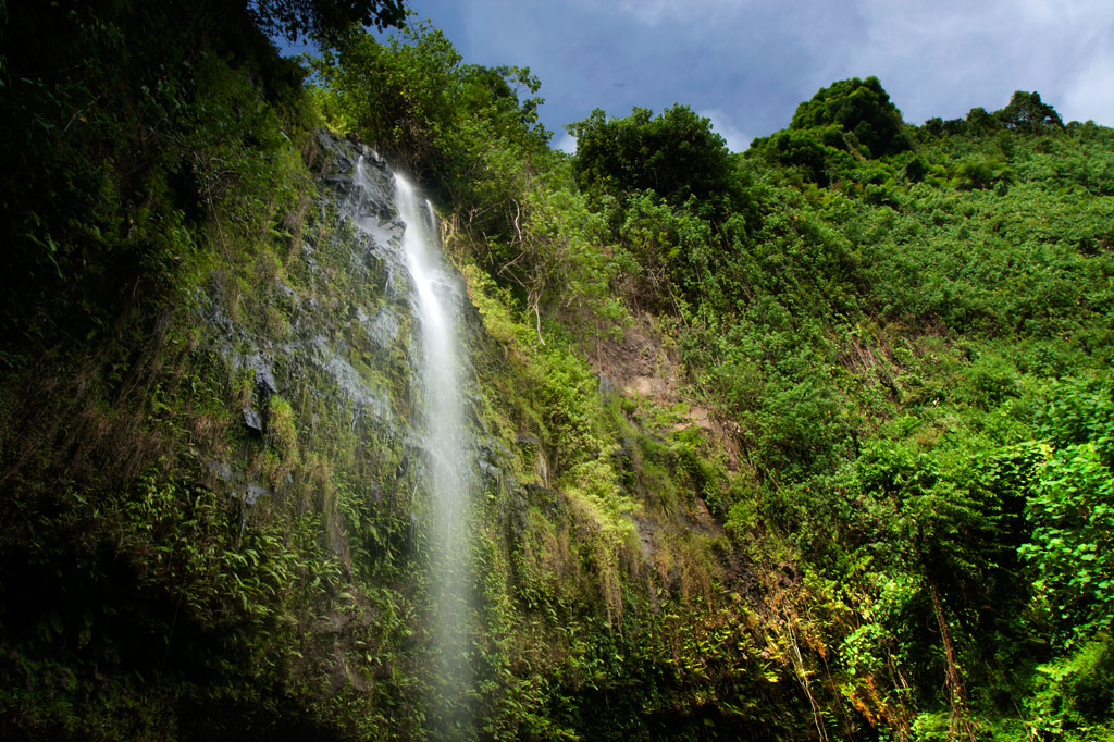
Because Pohnpei’s rainforested terrain is so challenging to move through, inexperienced hikers might think a jaunt into the wild interior of the island is out of reach. It isn’t. Almost anyone in relatively good physical condition can handle the “Six Waterfalls Hike”, which delves into the verdant forests and lush raparian environment of the remote Nanmeir Valley above Salapwuk.

The adventure begins near Salapwuk Elementary School. The early part of the hike follows a wide, mostly flat track through the trees. This is a good place to look for Asian waterbuffalo, or carabao, which some of the Salapwuk residents use as beasts of burden. The large, big-horned animals, which were brought to Pohnpei from the Philippines by the Spanish in the 1890s, may look fearsome, but are actually quite shy, gentle creatures. You might see one lolling about in a patch of mud or plodding along with a smiling child perched on its back.

Nan Emp Waterfall, Pohnpei, Federated States of Micronesia (FSM)
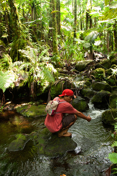
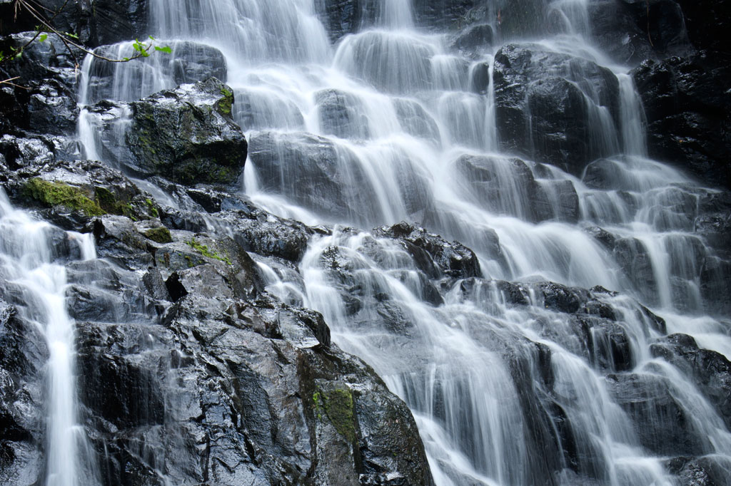
Over time the track becomes a narrow footpath and begins to roll up and down as it passes through hilly native forests. Shortly after crossing the Sihngar Stream (Pilen Sihngar), there’s a fork in the trail. Continuing straight will keep you above and west of the river, while the eastern way leads down toward the upper Lehnmesi River and Pahnairlap, a serene punchbowl falls with a great little pool beneath it.

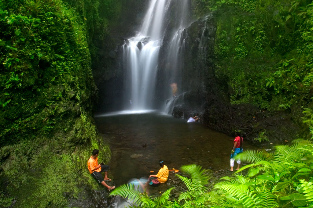
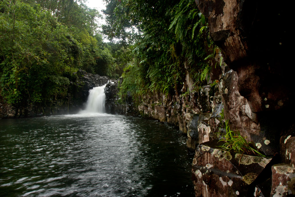
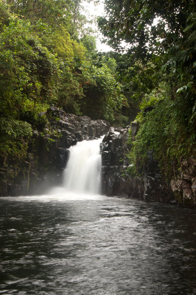
The rest of the hike follows along the banks of the river and occasionally crosses over it, stopping at four more waterfalls — Nikotoapw, Olotong, Iro, and Nan Emp — each with its own unique character. This segment is quite difficult, as hikers must traverse the round, jumbled stones that line the riverbed and its banks. Go slow, use your hands, and watch your footing.

Nikotoapw Waterfall is found a bit to the east of the river, above where the Nikotoapw Stream (Pilen Nikotoapw) joins the Lehnmesi. The site is screened by a pool with a wide “block falls” behind it, which hikers must circumvent. On the other side, the stream issues from a narrow slot. Continue through this and one comes to an enclosure mostly hidden from outside. There lies the falls and its sizable pool. If you swim under the falls and climb up on the rocks behind, you’ll find a cave.

Hikers on the Six Waterfalls route, Pohnpei, Federated States of Micronesia (FSM)
The third falls, Olotong, is found on the opposite side of the Lehnmesi from Nikotoapwpw. This is followed by plenty of hiking in the riverbed and one segment where the trail leaves the river and cuts through the forest before coming back to the watercourse. Iro and Nan Emp are both found on the west side of the river not too far apart.

The sixth falls, called Lipwentiak, is also hidden from view by the topography. At one point the river narrows and passes through a high-walled slot. Though there is a way up and around, the easiest and safest way past is to swim through the slot. On the other side, the walls open up to reveal a large pool with high walls on all sides, an island of cobbles, and beyond all that, a tiered “horsetail falls” that flows from a vaguely heart-shaped portal of dark rock. It’s very dramatic.

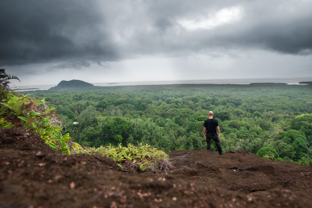
In all, the trek offers tons of great swimming and truly unreal scenery. Good footwear is a must.

  • Plan for 6-8 hours round-trip with short swim breaks at each waterfall.

The Story of the Eel of Pahdol

A long time ago, a couple from Wene came to live in a place called Iro. One day there was a great storm and the heavy rains resulted in a huge flood. Two women in the area went out to fish in the flood, and while they were fishing, a starling flew over and dropped a small stone. The women took the stone home and gave it to the couple from Wene. Later, at a place called Pahnkipar (“under the pandanus tree”), the stone broke apart and from it was hatched a tiny freshwater eel. The couple kept the eel as their pet and allowed it to live in a pool at Pahdol (“under the hill”) in Pahnais. When the eel grew up, however, it began to act in sinister ways. At night, the eel would escape from its pool and sneak into the house, where it would stare at the sleeping couple. The couple became uncomfortable and decided to kill and eat the eel, but the eel overheard their plan, came into the house, and attacked them. The couple fled into the forest and hid under a huge rock, where they believed they’d be safe. The eel discovered the hiding place and ambushed the couple, devouring them alive.

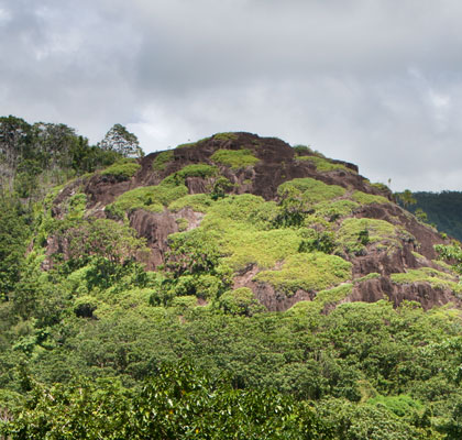
The eel then traveled into the Nanmeir Valley in Pohnpei’s interior and followed the Lehnmesi River source. There she met Kiroun Meir, a high-titled man, who brought her to live with him at his home. The two became lovers and the eel was impregnated. She was restless, however, and departed, continuing to follow the river. At Lipwentiak, the eel encountered a hunter named Kiroun Mand, killing and eating eels. Recoiling at this sight, she created a sharp turn in the river with the writhing of her body. Soon after, she gave birth to her first daughter, the matriarch of the Sounlipwentiak subclan. She had other children later who became the founders of the Lasiadohng (“eels of the dohng tree”) and Lasiakotop (“eels of the kotop palm”) subclans. After that, the eel went to live in Dauen Sapwalap, where she terrorized the local inhabitants, devouring so many that the land became mostly deserted. When the monster finally died, her body formed Dolen Nett.

Map Guides >> Western Kitti >> Six Waterfalls Hike

Pohn Pehnmen Savannah

Mallen Pohn Pehnmen

In the remote mountainous area called Pohn Pehnmen is an upland savannah similar to those on the Nihpit plateau, but smaller and at a much higher elevation. The meadow, reached by deviating west from the Enipein Powe trail to Nahnalaud, has a strong slope to it with a central hill and an open view of the ocean and lowlands. Most of the area is covered by low, spreading ferns and club moss, while giant tree ferns and endemic kotop palms (Clinostigma ponapensis) are clustered along the fringe.

Like Nihpit, the moderately difficult, but rarely steep, trail is dominated by groves of Atuna racemosa, which Pohnpeians call ais. This tree’s unusually hard wood, termite-resistant quality, and straightness makes it a popular choice for construction projects on the island. The fruit are also used medicinally and to create the red paint commonly used on Pohnpei canoe hulls. You’ll see bio-luminescent salengen eni (“ghost’s ear”) mushrooms, many types of bracket fungi, including one that has sadly been the target of poaching by visitors from at least one Asian nation, and a startling diversity of bryophitic growths on trees and logs. There are a number of small stream crossings. Birders will find a lot to look at both in the forests on the way up and around the meadow.

The hike begins at the end of the road near the FSM Telecom mobile phone tower, cuts through a grassy clearing, and enters the first. The 0.26 km (0.16 mi) to the first branch in the path is mostly flat; bear right. After that it climbs pretty steadily for 1.4 km (0.87 mi) at about a 17-18% slope. There’s another branch about 0.52 km (0.32 mi) from the top; again, bear right.

  • Plan for 5-8 hours for this hike.
  • Please visit the Local Guides & Tour Operators page for a list of experienced guides available for hikes to Mallen Pohn Pehnmen. Offer $25-50.00 for a group of five or less.

Map Guides >> Southern Kitti >> Pohn Pehnmen

Dolotomw Summit

Dolotomw is the highest peak in the region of Kitti once known as Onohnleng. Its prominence led Russian explore Fedor Lütke, in 1828, to incorrectly conclude that it was the highest point on the island. The Spanish called the peak Montesante (“saint mountain”). Pohnpeians originally called it Dolen Ne, but the name was later changed to Dolotomw (see legend below).

The challenging hike to the overgrown summit begins on the north side of an unpaved secondary road in Pahnais, west of the turn-off for Nipai Rock and climbs a total of 2.47 km (1.5 mi) to the peak, crossing an open savannah in the region of Lukeileng about half-way along. This spot, in itself, is worth visiting even if you don’t plan to continue up the mountain. There are great views and there’s plenty of space to pitch a tent, though no fresh water nearby.

At the beginning, the trail runs north for 0.3 km (0.18 mi) at a steady slope of 17% before reaching a group of residential buildings, where your guide will ask permission to proceed. The trail then angles northeast and steepens to about 20-22% for the 0.68 km to the upland meadow in Lukeileng. From the middle of the meadow to the base of the mountain is another 0.9 km (0.56 mi) with a more moderate slope of about 13%. Here, there’s a branch in the path. The eastern branch leads to a tiny cave. Stay on the northern track for the summit. At this point, the real climb begins and is quite steep and grubby much of the way (40-44%). The trail vanishes. Hikers must follow their guide more or less straight up the hillside, using natural hand and footholds — rocks, tree roots, etc. There’s a false summit about 130 m (142 yd) from the top, but trees and bushes obscure the views. The true summit is behind a knoll and is criss-crossed with WWII-era Japanese trenches.

  • Plan for 8 hours for this hike.
  • Please visit the Local Guides & Tour Operators page for a list of experienced guides available for hikes to Dolotomw. Offer $50.00 for a group of five or less.

The Story of Apology Peak

Long ago, a man named Manendolenne (“man of leg hill”) lived at the summit of what is now called Dolotomw. He had a little house there and felt secure, because he was isolated from other people who might wish to cause him harm. Now, there was a demon who lived on Penieu Island and it had a fishpond there stocked with butterfly fish. Manendolenne could see the sun glinting on the surface of the pond from the top of the mountain and became curious about it. One day, while the demon was away, he went down to Penieu and stole some fish from the pond, took them back to his home, and ate them. When the demon saw that someone had stolen his fish, he immediately suspected Manendolenne and went looking for him. Manendolenne heard that the demon was looking for him and prepared pounded taro balls with coconut cream as an offering of apology for what he’d done. When the demon arrived, Manendolenne offered the food to the demon. Ever after, the peak was known, not as Dolen Ne (“leg hill”) but as Dolotomw (“apology peak”).

Map Guides >> Southern Kitti >> Dolotomw

Nipai Rock

Nipai Rock, Pohnpei, Federated States of Micronesia (FSM)

Unlike some of the other unusual rock formations on Pohnpei, the massive rock of Nipai is easy to miss. Obscuring trees prevent it from having the prominent visibility on the Circle Island Road that would make it an eye-catcher, even though it’s only about 230 meters north of the asphalt. Never the less, this utterly huge 160 by 120 meter basalt outcropping in Enipein Powe is wholly unique, easy to access, and absolutely a must-see for any adventurer. The rounded shape of the rock and its many terraces are probably a result of erosion and may indicate that the feature is much older than other more jagged outcroppings like Pwisehn Malek and Sokehs Rock.

The unpaved turn-off on the inland side of the road is 2.2 km (1.37 mi) east of Enipein Pah Elementary School or 1.34 km (0.83 mi) east of the Semwei River bridge. From there, it’s an easy 0.37 km (0.23 mi) walk along the dirt road to the last house (9-17% slope), where a 0.2 km (0.12 mi) footpath leads east (4% slope average), crosses the small Nanwou Stream (Pilen Nanwou) and arrives at the western base of rock. View north from Nipai Rock, Pohnpei, Federated States of Micronesia (FSM)The slope is not too steep here and there is a corridor (36% slope average) where you can find your way up without much difficulty or danger. Once on top, the levels of the rock can be explored and the spectacular view enjoyed in full.

Camping

Many locations on the terraces are perfect for tent camping, and you can filter water at the Nanwou Stream (Pilen Nanwou).

The area in which the trailhead resides is known locally as “Palkalou” and belongs to the Palasko Family. The first house on the left after crossing the bridge heading to Pahntehlap is the residence of the landowners (marked on the map with a yellow star). An access fee is charged by the landowners for non-resident visitors, all visitors must ask permission at the house before hiking on or camping. 

  • Plan for 2 hours for this hike.
  • Contact: John Palasko – (691) 921-3814

Map Guides >> Southern Kitti >> Nipai Rock

Lehnpaipohn Waterfall

Lehnpaipohn Waterfall, Pohnpei, Federated States of Micronesia (FSM)

Kitti has a lot of waterfalls, but one of the most fun to visit is Lehnpaipohn between Salapwuk and Pwoaipwoai districts (at least two kousapw claim the falls area). It is neither the tallest waterfall on Pohnpei nor the most picturesque, but what Lehnpaipohn does have is the largest freshwater pool on the island (about 80 by 30 meters) and the highest jumping-off spot. The pool is leaf-shaped, very deep, and surrounded by high cliffs with a sizable island of river cobbles in the center. The water is typically quite chilly, which is a good thing after the hike. The waterfall itself is not much more than 4 meters (13 ft) tall and has a platform of rock behind it that you can stand on. Swimming to it is difficult, however, because of the strong current coming away from the falls. The best tactic is to swim along the edge and use the rocks to pull yourself forward.

The trail is only 0.53 km (0.33 mi) from the unpaved secondary road, but that road’s conditions are so bad that you’ll want to park your vehicle way down at the end of the paving 0.4 km (0.25 mi) above the Circle Island Road and walk up (5-15% slope with an average of about 7%). Look for the unmarked footpath on the left 2.18 km (1.4 mi) beyond the paving and 117 meters (128 yd) past the last visible residence on the right. The path is well-defined, relatively easy to follow, and downhill almost the whole way to the river (12% slope average). It stays under the trees and is rocky except at one point, where there’s a swampy section to cross or navigate around. About 216 meters (236 yd) along, the path branches; stay to the left. Another 200 m (219 yd) brings hikers to a small stream crossing. From this point, there’s only another 89 m (97 yd) to go. The final descent to the pool is exposed and a bit sketchy (especially when descending); make sure you have good footwear (FiveFingers are best, but good tennis shoes will work, too) and take special care on wet days.

No fees are charged and the trail is on public land. You can do this hike without a guide.

Camping

You can camp under the trees at the top of the eastern cliff — also the spot from which swimmers leap. Pack out everything you brought in and leave the site as you found it.

  • Plan for 3-4 hours for this hike including some quality time to swim and relax.

Map Guides >> Southern Kitti >> Lehnpaipohn Waterfall

Nihpit Plateau Savannahs

Mallen Nihpit & Mallen Pitetik

A stream on the path to Nihpit, Pohnpei, Federated States of Micronesia (FSM)

On the large upland plateau of Nihpit in the mountains above Mwoakot are two expansive savannahs or fern meadows. Upland savannahs of this sort usually exist because the bedrock is shallow, but they are also periodically burned by residents, inhibiting the growth of larger shrubs and trees. Hunters say that the Philippine sambar deer that live in Pohnpei’s interior — probably introduced by the Germans from the Mariana Islands — are attracted to the ash. One hunting tactic is to lie hidden at such sites and wait for the deer to creep from the forest in the early dawn (photographers might use the same method). Both of the savannahs soak up rain and feed tributaries of the Ne Stream (Pilen Ne). The northernmost and the larger of the two meadows — about a half kilometer in length — is usually referred to as Mallen Nihpit. The other savannah is Mallen Pitetik. Birders and photographers will find this a wonderful place to camp and observe fauna rarely disturbed by human activity. The palm forests around the edge provide plenty of shade, and drinking water can be filtered at the stream about 100 meters away.

Moss on the path to Nihpit, Pohnpei, Federated States of Micronesia (FSM)

The hike begins on the right side of the unpaved secondary road opposite the track leading to the Wene Latter-Day Saints Church — 0.92 km (0.57 mi) past the Nanwou Stream bridge — and leads up to a farmstead. Your guide will stop at a cluster of residential buildings to ask permission to cross the family’s land before leading you on. About 160 m beyond this is the first of two major stream crossings — one on a log and the other across a covered wooden bridge. After the second bridge, the trail climbs steadily for 1.47 km (0.9 mi) at a 25% slope average into forests full of huge Terminalia carolinensis (kehma) — found only on Pohnpei and Kosrae — and Atuna racemosa, a tall, straight hardwood locally called ais. The latter have many uses including treatment of diarrhea and dysentery. The white nut inside the ais fruit is ground and mixed with red soil to produce paint for canoes, while the extremely hard and termite-resistant lumber is a favored building material. If you hike in the evening, keep an eye out for eerie salengen eni (Filoboletus manipularis), bioluminescent mushrooms said to grow in areas where ghosts reside (the name means “ghost’s ear”). The tiny fungus often grows from rotten logs and looks like clusters of eyes in the dark. Interestingly, some Pohnpeian parents are known to control misbehaving youngers by threatening to send them to places where the mushrooms thrive. At this point, hikers have reached the edge of the plateau and the remaining 1.08 km (0.67 mi) is relatively flat with a 6% slope average. There are four small stream crossings along the hike. The first three come down from Mallen Pitetik and converge, forming a high waterfall as they drop off the plateau; follow the second stream up for 0.34 km (0.2 mi) to reach that savannah. The last stream originates in Mallen Nihpit and makes a good place to filter/purify water when camping in the area.

  • Plan for 8 hours for this hike.
  • Please visit the Local Guides & Tour Operators page for a list of experienced guides available for hikes to Nihpit. Offer $50.00 for a group of five or less.

Map Guides >> Southern Kitti >> Nihpit Plateau

Rohi Waterfall

Gel ginger in Rohi, Pohnpei, Federated States of Micronesia (FSM)

Hiking / TrekkingWaterfallSwimmingPicnicking

Rohi, the first district in Kitti after passing over the border from Madolenihmw, is host to an obscure, but beautiful, waterfall that few people — other than those who live practically at its feet and some Peace Corps volunteers stationed in the neighborhood — seem to know about. The high, sometimes wispy, falls plummets over a sheer wall hung with ferns and other climbing plants and is reminiscent of Sahwartik in Salapwuk, but with a much smaller and shallower pool and less volume overall. It’s unclear whether it has an official name; local residents mostly call it the “Rohi Waterfall” after the district within which it lies or “Nan Rohi Waterfall” after the name of the river.

Hardwood forest in Rohi, Pohnpei, Federated States of Micronesia (FSM)

To reach it, it’s best to park near the turn-off from the Circle Island Road, walk up the steep gravel secondary road, and continue to the houses at the end (bear left at the one major branch). Along the way is a stunning stand of huge hardwoods that are well-worth a good look. Once you reach the houses, you’ll want to ask permission to proceed, as the footpath crosses through several families’ front yards. The residents in the area, however, are welcoming and will likely be happy to show you to the falls or at the very least point you in the right direction. Once the path reaches the watercourse, the waterfall is evident just a bit upstream and one has merely to scramble along the rocky bank to the pool. The water is very clean and cool, and the spot is excellent for a short swim.

No fees are charged for this hike.

  • Plan for 1 hour round-trip with some swimming time at the falls.

Map Guides >> Southern Madolenihmw >> Rohi Waterfall

Nanpohnmweli Waterfall

Nanpohnmweli Waterfall, Pohnpei, Federated States of Micronesia (FSM)

Hiking / TrekkingWaterfallPicnicking

Though you can reach the top of Nanpohnmweli from Mand, the best way to access this falls (also known as “Kerenis” Waterfall) is from the Circle Island Road in Sapwehrek Kousapw. The walk begins at Benford Etse’s residence immediately south of the bridge and the sign for the Senipehn River Reserve and takes less than 10 minutes each way, following a well-trodden path that the family uses for planting sakau.

It’s hard not to be impressed by the place, even if you’ve already seen many of Pohnpei’s waterfalls. Like Kepirohi, the water tumbles over a gently sloping basalt wall rather than falling straight down over a cliff, but this falls is narrower.

Unfortunately, testing in April 2013 indicated that this site had 2.5 times more E. coli than is considered safe for swimming, so you’ll want to stay out of the water.

The Etse family doesn’t charge an access fee to visit the falls, but since you’ll need someone to show you the way through their property, offer $5.00.

  • Plan for 45 minutes round-trip with some time to admire the view of the falls.

Map Guides >> Southern Madolenihmw >> Nanpohnmweli Waterfall

The Rock of Silehu

Silehu Rock, Pohnpei, Federated States of Micronesia (FSM)

Southern Kitti’s most obvious natural feature is the Rock of Silehu — a spire of basalt rock that stabs out from the hills above Nintok. Because of its phallic shape, some have jokingly referred to the rock as the “giant’s penis,” but there is little to suggest that the idea has any basis in Pohnpei’s traditional myths, and it is more likely a transplant inspired by Kosrae’s well-known “Sleeping Lady.”

The local area has garnered some fame through its association with Luelen Bernart, the first Pohnpeian to ever pen a history of the island and probably the first Micronesian to write a book of any kind. It was a revolutionary endeavor. Pohnpei had a long tradition of story-telling and transmission of traditional knowledge through oral means, but writing things down was wholly new. Furthermore, it was believed on Pohnpei — and still is today — that a person should not share all that he knows on any subject. Bernart, born in Wene, Kitti, but educated in the same Protestant mission school as Henry Nanpei (they were close friends and his wife and Nanpei’s wife were sisters), was possibly inspired by the Western ideas he absorbed there and his exposure to the Bible, whose style and structure is similar to his writings. Bernart came from the noble class. Over his life, he acquired the title Dauk — the third-highest title on the Nahnken (talking chief) line — and became well-respected in the ceremonial arena as an orator and story-teller. This experience, combined with the skills he acquired in school, gave Bernart what he needed to tackle such a singular task. In the 1930s he began composing what would become The Book of Luelen — a sprawling collection of myths and legends, songs, chants, magical spells, plant-lore, and modern history. Though Bernart died before he could edit the work, his daughter and her husband labored to complete the manuscript, which was eventually translated and published in the 1970s. Bernart was buried in Rehntu.

The Story of Lihser

As far as oral history is concerned, Silehu is connected to a story that began in the Awak Valley of U. A spirit called Lihser dug up the ground and buried two boys in the earth at Awak. Scooping up the lumps of earth in which the boys were buried, he threw them to Silehu. The body of one boy, named Kier, formed the Peisarap hills where it fell. The spirit then built an altar called Pein Maram (“altar of the moon”) to honor the spot where the other fell. Later, the spirit met a hermit crab with a human skull for a shell. Upon searching the area, Lihser found the bones of a man. He took the bones and the crab and buried the skull-shell at a place he named Nintok. The rest of the bones were buried at another location called Antak.

Interestingly, one ethnographer reported that people from Nintok are prone to a “peculiar form of craziness” and erratic behavior that intensifies on full moons.

If you have a tough, high-clearance vehicle, you can begin your hike at the Esiel house at the end of an unpaved road that leads north from the Circle Island Road. Otherwise, it’s best to park down by the CIR and walk up, as the upper portion of the road is rough and has a grade of at least 19%. This segment is moderately difficult on foot, but treacherous by car. The hike from the house is short but steep (about 30% slope average), following a narrow footpath that the family uses regularly. The final part of the ascent is very steep and scrubby. No technical climbing is involved to reach the tiny, exposed summit, but there are some sections that might be uncomfortable for people afraid of heights. From the top, unobstructed views extend in all directions. Prominent sights include Dolotomw, Mwudok Harbor, Mwudok Island, and Nipai Rock.

  • Plan for 2 hours for this hike. For guides, ask for Wainer, Raynard, or Treveyne and offer $10.00, or call +691.320.5059 ahead of time to make arrangements.

Map Guides >> Southern Madolenihmw >> Silehu Rock

Scroll to top