Daumwoakote

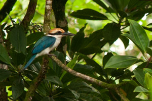
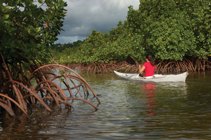
Daumwoakote, the magical 2 km (1.24 mi) mangrove passage running between Sokehs Island and Pohnpei Island, is an absolute must-see for anyone with a heart for adventure and an eye for beauty. If you launch opposite St. Peter’s Church, you can catch the tide and cruise west through the tunnel-like avenue of trees to the accompaniment of a chorus of birds. Early in the morning and late in the afternoon there are so many winged creatures around that the place feels like an aviary. The trees are also bewildering–great twisted wonders with looping prop roots and spiking pneumatophores. The mangroves propagate both by dropping dart-like propagules into the silty mud and by sending down hundreds of dangling extensions that add to the primordial atmosphere. Several species are found in the area. About two-thirds of the way through, you have the option of continuing in the main channel or deviating to one of two smaller passages just wide enough for a kayak or canoe.
Sokehs Island Circumnavigation
From the west end of Daumwoakote, roughly 10 km (6.2 mi) remain to completely encircle the island. Along the way, you’ll cross emerald reef pools in the bay, skirt dense mangrove forests, and get fantastic views of the green cliffs of Pohndollap. The “Doldrums” at APSCO makes a perfect spot for a rest, a rejuvenating swim, and a snack.
The Labyrinth

The “Labyrinth”, located southwest of Daumwoakote at the mouth of the Nankewi River, is composed of hundreds of small mangrove islets growing in a dense cluster. There is no particular route–just paddle in and let yourself wander through the myriad passageways and shallow pools, inhabited by crabs, the occasional black-tip reef shark or hunting snapper, communities of juvenile fish, and a variety of seabirds and shorebirds. The water depth ranges from a half meter to 1.5 meters.
Note that the area between the Sokehs Island Bridge and Daumwoakote is very shallow at low tide, and at high tide, you may find that branches over the water don’t give you much room to move. Most of the routes on this guide, however, should be passable during all but the most freakish of tidal fluctuations.
Paddling Distances Around Sokehs Island
| Starting | Ending | Distance (km) | Distance (mi) | |
| Sokehs Island Bridge* | —- | Daumwoakote West End | 1.97 km | 1.22 mi |
| Daumwoakote West End | —- | The “Doldrums” | 4.41 km | 2.57 mi |
| The “Doldrums” | —- | Danipei Portage Point | 2.49 km | 1.55 mi |
| Danipei Portage Point | —- | Sokehs Island Bridge | 2.91 km | 1.81 mi |
*Silted-in estuary. This segment may be difficult to traverse at low tide.

