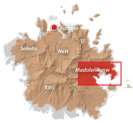
An Introduction to Madolenihmw
Madolenihmw (pronounced mä.tō.lĕn.eem) is the largest of Pohnpei’s five chiefdoms and was the first to be established in the late 1600s by Isokelekel, conqueror of the Saudeleurs and Pohnpei’s first Nahnmwarki (paramount chief). It originally included the areas that now comprise U. The name means “spaces separating the houses” and refers to the district’s history of disunity and its many conflicts and power struggles.
During the 1830s, Madolenihmw’s natural harbors became popular ports-of-call for American and English whaleships, working the Pacific, and its wide lands a haven for morally-challenged Westerners who caused all sorts of havoc and participated in more than one violent engagement. The most high-profile event centered around the visiting whaleship, Lambton, and developed into a full-blown war between the Nahnmwarki and the Wasai, a rival chief, who was supported by the whalers. The fight ended with the murder of both the Nahnmwarki and his high-titled brother, Nahnawa, and the installment of the Wasai as the new paramount chief.
In 1890, Madolenihmw again became a battleground when the Spanish colonials attempted to build a Catholic mission next to the already existing Protestant church. Fighting ranged from Ohwa to Kitamw and cost the Spaniards a great deal more than they gained.
Madolenihmw today is a relaxed, simple place and reminds one (to quote a famous author) of a time “long ago in the quiet of the world, when there was less noise and more green . . .” It is a place that one can’t help but love.
Central Madolenihmw Attractions
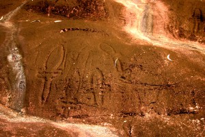
Just south of the newly renovated Sapwalap Elementary School lies one of Micronesia’s most unusual sites. More than 700 prehistoric motifs are inscribed on rocks in the area, the largest collection adorning a 60 by 25 meter naturally terraced basalt ...
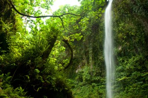
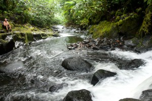
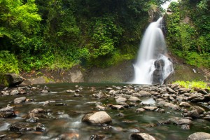
Pahnsapw, which means “beneath the land," refers to a pair of tall, majestic waterfalls which plummet off the edge of a high plateau in central Madolenihmw (it's also the name of the farmstead). Both waterfalls are found on the land ...
Dolen Merewi is a flat-topped hill that stands apart from the interior mountains to the west and is highly conspicuous when driving through northeastern Madolenihmw. During the Spanish Period (1886-1898), the hill played a pivotal role in an armed conflict ...
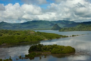
Dauen Sapwalap / Senipehn Mangrove Reserve Visit the Paddling Around Madolenihmw page for a detailed description of this location and the adventures to be had in the area. Entering the mangrove reserve requires a permit. Visit our MPA page for ...
This route passes through the gorgeous valley of Nankepinmerepw, following the upper tributaries of the Nan Riohk Stream (Pilen Nan Riohk) and eventually arriving north of Nahnalaud on an arm of the major mountain system. One guide stated that the ...
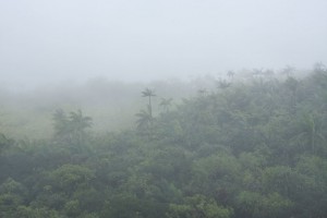
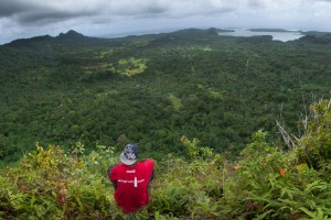
The Big Mountain The highest mountain in the Federated States of Micronesia (FSM) is called Nahnalaud (which means "big mountain") and is located almost in the exact middle of Pohnpei Island. Pohnpeians consider the mountain sacred and regard it with ...
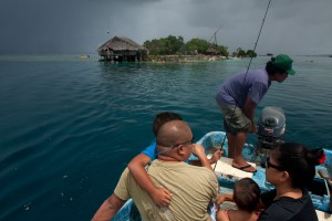
Dahu Reirei (“long channel”) is a long, narrow, man-made islet constructed on a shallow reef with several huts for picnickers and campers and lots of pleasant swimming and snorkeling nearby. The tiny place can get uncomfortably crowded on weekends and ...
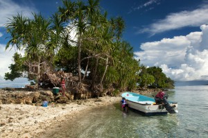
This island is claimed by the same family as Dahu Reirei and has no true name, but as it lies adjacent to the primary channel every boat in the area uses to go from Areu and Ohwa to Madolenihmw Bay, ...
Mwudokolos is found a half-kilometer (0.33 mi) northeast of Metipw and easily accessed from the coral-dredged causeway/dock found there (ask at the nearest house for permission to launch if you're paddling out). The privately owned, but uninhabited, island has prehistoric ...
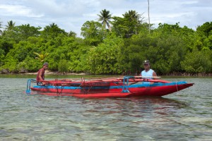
Dauen Sapwalap / Senipehn Mangrove Reserve Dauen Sapwalap is the largest drainage in Madolenihmw, a wide, meandering channel that cuts through the mangrove forests from Kitamw and eventually empties into Madolenihmw Bay. Although the Lehdau River (Pillapen Lehdau) is probably ...
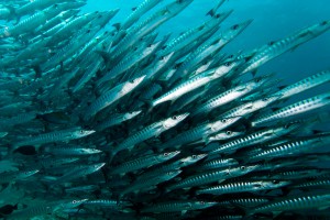
"Straight Wall" This dive is on the outer edge of the long, straight fringing reef east of Nahnningi (Joy) Island. It's a good place to see schools of tuna and barracuda hanging out beyond the wall. It's also one of ...
Downloadable GPS Data Files The following files contain all the packaged GPS data for each of the featured locations in the (Central) Madolenihmw Eco-Adventure Map Guide. Three file types are provided. KMZ and KML files are compatible with Google Earth ...
Marine Protected Areas (MPA), Sanctuaries, and Forest Reserves Pohnpei Island currently has thirteen marine protected areas, including three mangrove forest reserves and two stingray sanctuaries. Additionally, Pakin Atoll has five of its own MPAs and all of Ahnd Atoll is ...
Temwen Vicinity Pahn Nahkapw Wall The best snorkeling in the area is west of Nahkapw (island) along the edge of the reef, where a coral wall drops quickly off into Pahn Nahkapw's blue hole. Fish are abundant here and the ...
Located on the pristine Senipehn River, Pahn Sile is one of the few waterfalls well into the interior that almost anyone (even small children) can reach without the help of a guide -- as long as you keep your eyes ...

The Best Type of Bike Pohnpei is a wild place. There are no paved bike paths or bike lanes on the roads. Off-road conditions are muddy, rocky, slippery, and very rough. Potholes are everywhere. For these reasons, mountain bikes are ...
Swimming & Picnicking
When the heat gets to be too much, Madolenihmw offers plenty of places where you can take a dip and cool off. Aside from the many waterfalls (Pahn Sile, Pahnsapw, Nankep, and Nankepinmerepw) and islands (Mwudokolos, Dahu Reirei, Nahpali, Dekemwahu, Na, Nahkapw, Nahnningi, and Mall) in the general area, one of the best places to swim is at the Lehn Diadi bridge (the name is roughly translated “pool of the floating place”). There are deep pools for swimming on both sides and beneath the bridge and grassy areas on the cobbles along the bank for picnicking. Below the bridge, a portion of the old Circle Island Road still lies across the stream. Park on the side of the road near the bridge and find one of the footpaths leading down.
ACKNOWLEDGMENTS
Kalangan to Miller Benjamin, Relio Lengsi, and Danny Rosenkrans for helping to check central Madolenihmw’s place names for accuracy; Peterson Anson of Pohnpei Transportation & Infrastructure for helping to create the beautiful shaded relief on our maps; Danko Taborosi of Island Research & Education Initiative (IREI) for his considerable support and technical assistance.
Eco-Adventure Map Guides >> (Central) Madolenihmw