
Paddling Lenger & Sapwtik
![]()
![]()
![]()
![]()
As the closest lagoon islands to Kolonia and with the highest concentration of WWII historical sites anywhere around Pohnpei, Lenger and nearby Sapwtik make fantastic destinations for paddling enthusiasts. In addition to the attractions on each of the two islands, there are mangrove forests and some interesting reef environments to explore.
Around Lenger
Pahnaiau Getaway (Barbosa’s Wharf) to the Seaplane Ramp
This portion of the route is characterized by Lenger’s shallow fringe reef, a sandy, silty expanse dominated by small-scale coral growth, brilliant blue starfish, cowries, sea cucumbers of various types, and scattered beds of seagrass, which Pohnpeian’s call oaloahd. Keep an eye out for the main attraction: stingrays. They generally rest on the bottom in the sand and will shoot off when you approach. Not far beyond the wharf is the Jaluit Cistern, one of the oldest historical sites in Pohnpei State. The cistern was probably constructed in the late 1880s by German traders operating on the coast. A stone wharf originally connected it with the coast, but a few scattered stones are all that are left. Bullet holes in the masonry were caused by Allied strafing during WWII.
If you decide to make a wider arc around the island, you’ll pass over areas where the reef shelf ends and the deep part of the lagoon begins. Small sea turtles are seen on rare occasions near the reef wall. The majority of the reef fish will also be found at this natural boundary. Note, however, that the reef stretches all the way to Sapwtik in the northwest and there is no way around Lenger’s northern end without crossing it. The depth over the shelf varies from a few centimeters to a meter, depending on the time of day and the precise location. Because fragile corals and other organisms are harmed by feet or dragging keels, the northern passage should be attempted at high tide only.
The Seaplane Ramp to the Mangrove Passage
The reef on the eastern side of the island tends to be deeper than in the northwest and has denser beds of seagrass. Larger fish are found in this area, and sometimes juvenile black-tip reef sharks can be seen swishing their way around.
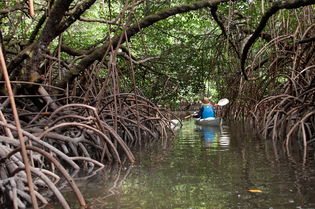
The Mangrove Passage to Barbosa’s Wharf
The tunnel-like mangrove passage winds about a third of a kilometer through a dense section of forest that mostly comprises members of the Rhizophora genus, identified by the arching prop roots that extend out of the water toward the tree trunks. It’s a nice, scenic paddle and a good place to spot shorebirds like the Pacific Reef Heron and Micronesian Kingfisher. Once out of the forest, you can follow the coastline past the ruins of the Japanese-era Kohatsu Wharf and back to Barbosa’s Wharf.
Around Sapwtik
A relatively well-preserved Japanese wharf extends southwest from Sapwtik’s coast all the way to the edge of the reef. This is a wonderful place for a picnic and swim or snorkel. There’s one large tree on the wharf, offering shade. To the west is a maze of mangrove clumps that are fun to paddle through (though they are not as extensive as Lenger’s) before reaching the western terminus of the island. North of the point is an exposed rocky place that’s a perfect pull-out spot for a snack. A little beyond that is the site of the coastal battery and nearby munitions magazine. Conditions north of Sapwtik’s coastline are very similar to Lenger’s northern sector — shallow and characterized by seagrass beds and silt. You shouldn’t try to kayak here except at mid to high tides. All along the coast, you’ll find evidence of Japanese occupation, low walls, foxholes, rifle pits, etc.
| Starting | Ending | Distance (km) | Distance (mi) | |
| St. Peter’s Church, Sokehs | —- | Pahnaiau Getaway, Lenger | 7.93 km | 4.93 mi |
| Misko Beach, Dekehtik Island | —- | Pahnaiau Getaway, Lenger | 4.52 km | 2.8 mi |
| Ice Dock, Kolonia Town | —- | Pahnaiau Getaway, Lenger | 3.53 km | 2.2 mi |
| Nett Point, Nett | —- | Pahnaiau Getaway, Lenger | 1.97 km | 1.22 mi |
| St. Peter’s Church, Sokehs | —- | Japanese Wharf, Sapwtik | 7.75 km | 4.81 mi |
| Misko Beach, Dekehtik Island | —- | Japanese Wharf, Sapwtik | 4.34 km | 2.7 mi |
| Ice Dock, Kolonia Town | —- | Japanese Wharf, Sapwtik | 4.23 km | 2.63 mi |
| Nett Point, Nett | —- | Japanese Wharf, Sapwtik | 2.95 km | 1.83 mi |
| Pahnaiau Getaway, Lenger | —- | Japanese Seaplane Ramp, Lenger* | 1.52 km | 0.95 mi |
| Japanese Seaplane Ramp, Lenger | —- | Mangrove Passage Northern Entrance, Lenger | 0.58 km | 0.36 mi |
| Mangrove Passage Northern Entrance, Lenger | —- | Kohatsu Wharf, Lenger | 0.42 km | 0.26 mi |
| Kohatsu Wharf, Lenger | —- | Pahnaiau Getaway, Lenger | 0.51 km | 0.32 mi |
| Pahnaiau Getaway, Lenger | —- | Japanese Wharf, Sapwtik | 1.29 km | 0.8 mi |
| Japanese Wharf, Sapwtik | —- | Gun Battery, Sapwtik | 0.74 km | 0.46 mi |
*Shallow reef shelf. This segment is only passable at middle to high tides.
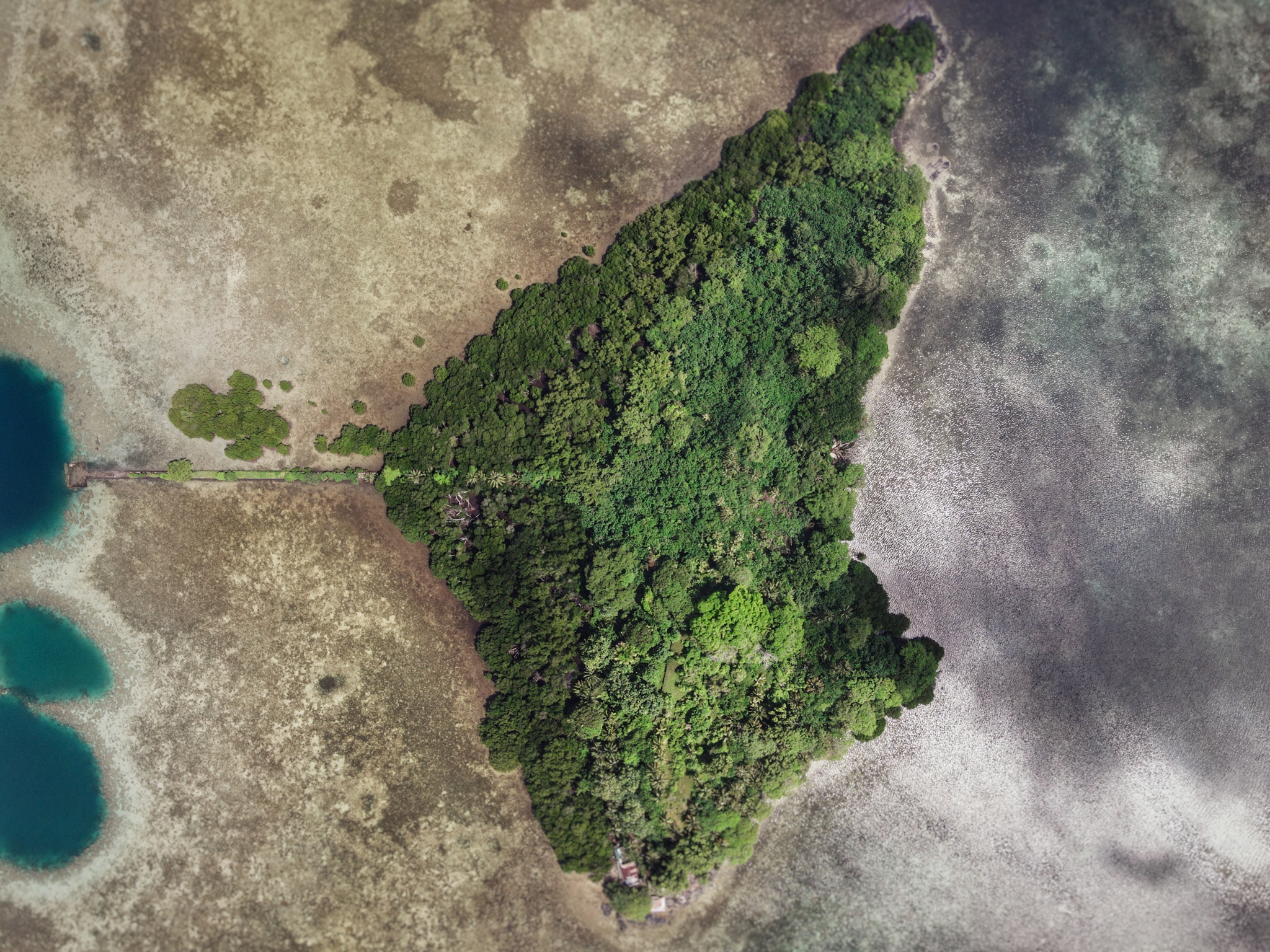
Sapwtik Island
Sapwtik, which means “small land,” is a tiny volcanic island located directly north of Kolonia and 0.5 km northwest of Lenger. Seen in profile, the island resembles a large submarine, leading some locals to nickname it “Submarine Island.” Sapwtik is jointly-owned by the Eschiet family, which has some small houses at the eastern end of island, and their in-laws, the Adams family. During the 1880s, Sapwtik was purchased by Jan Stanisław Kubary, a Polish naturalist and ethnographer, along with a large piece of land east of what is now Kolonia — a place called Mpwoampw. In 1896, after returning from an extended absence and finding his homestead in ruins and his claims on the properties questioned by the Spanish authorities, Kubary committed suicide. Mpwoampw and Sapwtik were then purchased by Dominique Escheit, a Belgian trader who had operated in the Marshall Islands before coming to Pohnpei. Between 1914 and 1945, the Japanese were in charge and a great deal of land was seized by the military for defensive purposes — including Sapwtik. Like its neighbor, Lenger, Sapwtik was fortified in the late 1930s in preparation for an Allied invasion that never came. The primary features are found on the low hilltop and at the western terminus.
Sapwtik Island Attractions

Japanese Wharf
Visitors to Sapwtik will want to make their first stop at the Japanese Wharf, a 296 meter-long (324 yd) basalt structure that juts out from the island’s southwest coast all the way to the edge of the reef. With the exception of the very end, which has sustained some damage from waves, the wharf is in excellent condition almost 80 years after it was built — a testament to the quality of Japanese construction during the colonial period (and the use of the highly stable tanizumi, or herringbone, style of stonework). The wharf connects with the coastal road, also built by the Japanese, which skirts the mangroves from one end of the island to the other. The road is built above a stone retaining wall that stabilizes it against the swampy mangrove environment. Retaining walls also run along the opposite edge to prevent erosion from the steep hillside above.
Snorkeling & Swimming
All the ocean areas around Sapwtik belong to the Sapwtik Marine Protected Area, a sanctuary protected by legislation. The snorkeling off the reef walls at the end of the wharf is quite nice with generally good visibility and lots of fish. Just start at the wharf and follow the reef wall in either direction (the further from the island, the better it gets). The best place to swim is also right off the end of the wharf. Shallow areas on either sides of the wharf are silty.
")
Command Center & Barracks
The central hill is most easily accessed from the maintained Japanese coastal road. About 60 meters east of the wharf, hikers can cut off the road and up the slope (another 60 m) to reach the summit. The Adam’s family keeps the hill extremely tidy, cutting the grass, planting flowers, and keeping the historical features free of vines and brush. The place has a manicured, park-like feel and a stunning view of everything to the south. One of the best preserved yabane-tanizumi style rock walls on Pohnpei runs the length of the hilltop on the south side with two breaks, where earthen ramps lead up to the top. Two foundations were likely a command center and a barracks for personnel stationed on the island. The northern foundation is the largest and has seven sets of steps leading up to where the floor once was. The structure itself would have been wooden, while only the support posts and the lower parts of the walls were concrete. Two large concrete cisterns are connected to the two foundations (check out the bullet holes from Allied strafing). At the north end of the complex, the hill road begins, cutting right through the hill and running all the way to the gun batteries at the northwestern end of the island. Some of the road is currently impassable due to piles of felled trees and branches, but it’s impressive none the less.
To visit the gun batteries, it’s best to return to the coastal road and hike northwest all the way to the end. The road is well-kept and easy to follow.
Magazine Complex / Shell Storage
From the cut-off point for the hilltop, it’s about 150 m (164 yd) along the road to the first point of interest, a high-walled magazine complex for heavy ordnance similar to the one at the coastal gun battery on Lenger. The surrounding basalt rock wall (also tanizumi style) runs north and then curves sharply back to the south to enclose the foundation of the magazine structure, which is about 6 meters long. On the inside of the enclosure, the walls are steeply sloped. There is no roof, but the entire feature may have been covered with canvas and camouflaged during war-time. The entrance is narrow — less than 2 meters wide — and curved.
Coastal Gun Battery
About 12 meters northwest of the magazine is the first of four 75 mm field gun stations. These are similar to the structures on Lenger, though the Sapwtik sites are more primitive with less concrete and more earthen features. No guns remain, and two of the sites may have been decoys that never had guns installed. Guns would have protected the primary entrance to Kolonia at Pweitik Passage (Kepidauen Pweitik) to the northwest. A footpath continues north past the gun emplacements and then turns southeast to follow the contour of the hill. Along this are a few stone rifle pits or machine gun emplacements. Old Japanese beer bottles litter the forest.
[info]NOTE: The ruins of a searchlight and a tunnel, cutting completely through part of the central hill, also exist on Sapwtik, but we did not have the opportunity to locate them during our brief period of fieldwork on the island. If you’re interested in seeing these features, contact Richie Adams at (+691.320.5735). The Pacific Wrecks website has photos of both.[/info]
- To obtain permission to visit, call Richie Adams (Adam’s Brothers Corporation) at +691.320.5735 or call Ace Hardware’s office at +691.320.2723.
ACKNOWLEDGMENTS
The Sapwtik Island information would not exist without the cooperation of the Adams family.
Lenger Island GPS Data
Downloadable GPS Data Files
The following files contain all the packaged GPS data for the Lenger Island Eco-Adventure Map Guide, including the island’s coastline, ocean depth info, ten meter contour lines, mangrove forests, roads and trails, land divisions, World War II features, modern features, and other points of interest.
Three file types are provided. KMZ and KML files are compatible with Google Earth. KML is compatible with Google Maps. GPX files can be imported into ArcGIS (a professional mapping application) and some hand-held GPS devices.
[info]NOTE: All files are free to the public and can be used for any purpose without permission.[/info]
Lenger Island (2016)
Coordinates
The following coordinates correspond with sites featured on the Lenger Island Eco-Adventure Map Guide. It is our dream to eventually create a Pohnpei GPS app that could be uploaded to smartphones and other devices, but for now, these points of interest can be entered manually in a hand-held GPS device as needed.
[info]NOTE: All GPS devices have a margin of error. That margin increases with interference — when there is a thick canopy of trees, during bad weather, or when mountains obstruct the satellite link. The geosynchronous satellites employed when navigating on Pohnpei are located low on the southwestern horizon, such that maintaining a strong connection while hiking on the northeast side of a given mountain range can be difficult. Coordinates on the northeastern slopes of mountains are less accurate than in other locations.[/info]
Southwestern Lenger
| Barbosa’s Wharf | —- | 6.993799° 158.228531° |
| Former Barbosa Resort Site | —- | 6.994306° 158.229159° |
| Japanese Coastal Warehouse Foundation | —- | 6.994406° 158.229708° |
| Japanese Underground Crude Oil Complex Trailhead | —- | 6.994717° 158.229517° |
| Gate 1 – Crude Oil Complex | —- | 6.995515° 158.230239° |
| Japanese Storage Caves Trailhead | —- | 6.993890° 158.230359° |
| Japanese Concrete Plant Trailhead | —- | 6.994275° 158.230646° |
| Japanese Concrete Plant Equipment | —- | 6.994502° 158.230447° |
| Ballast Hill | —- | 6.994418° 158.230380° |
| Japanese Cave 1 | —- | 6.994567° 158.231047° |
| Japanese Cave 2 | —- | 6.994792° 158.230931° |
| Japanese Cave 3 | —- | 6.994894° 158.230736° |
| Japanese Cave 4 | —- | 6.994950° 158.230661° |
| Japanese Above-Ground Oil Tank | —- | 6.993772° 158.230847° |
| Japanese Above-Ground Oil Tank Foundation | —- | 6.993894° 158.230716° |
| Path Intersection Point | —- | 6.993445° 158.230835° |
Southern Lenger
| Japanese Machine Parts | —- | 6.993100° 158.231317° |
| Japanese Square Cistern | —- | 6.993406° 158.231139° |
| Japanese Aviation Fuel Tank Trailhead | —- | 6.993896° 158.231492° |
| Japanese Aviation Fuel Tank Tunnel Gate | —- | 6.994211° 158.231342° |
| Japanese Rectangular Cistern | —- | 6.994006° 158.231840° |
| Japanese Machinery & Wheels | —- | 6.993628° 158.231561° |
Eastern Lenger
| Stream Crossing | —- | 6.995612° 158.232389° |
| Banyan Wheel | —- | 6.996089° 158.232106° |
| Dolen Lenger Trailhead (Eastern Route) | —- | 6.995896° 158.232360° |
Northeastern Lenger
| Japanese Seaplane Hangar Ruin | —- | 6.997648° 158.232069° |
| Compressor | —- | 6.997654° 158.232009° |
| Japanese Seaplane Strut | —- | 6.997610° 158.231969° |
| Japanese Seaplane Engine & Prop | —- | 6.997646° 158.231922° |
| Japanese Seaplane Carriers | —- | 6.997317° 158.231503° |
| Japanese Seaplane Ramp Trailhead | —- | 6.998005° 158.231864° |
| Japanese Seaplane Ramp | —- | 6.999088° 158.233040° |
Northern Lenger
| Well | —- | 6.998180° 158.231401° |
| Bomb Craters | —- | 6.998240° 158.230883° |
Western Lenger
| Japanese Coastal Barracks Site | —- | 6.996593° 158.228989° |
| Japanese Coastal Barracks Site | —- | 6.997418° 158.228861° |
| Dolen Lenger Trailhead Western Route A | —- | 6.997555° 158.229206° |
| Dolen Lenger Trailhead Western Route B | —- | 6.997874° 158.229242° |
Central Lenger (Hill Area)
| Intersection of Japanese Hill Roads | —- | 6.997592° 158.230367° |
| Tunnel Entrance | —- | 6.997431° 158.230122° |
| Japanese Dug-out 1 | —- | 6.997294° 158.230053° |
| Japanese Dug-out 2 | —- | 6.997325° 158.230153° |
| Japanese Gatepost | —- | 6.997197° 158.230789° |
| Dolen Lenger Japanese Cistern 1 | —- | 6.996967° 158.230894° |
| Cement Steps | —- | 6.996908° 158.230919° |
| Japanese Coastal Battery Trailhead | —- | 6.996659° 158.230743° |
| 15-cm Gun Station 3 | —- | 6.996673° 158.230400° |
| 15-cm Gun Station 4 | —- | 6.996549° 158.230341° |
| 15-cm Gun 4 | —- | 6.996589° 158.230353° |
| Japanese Heavy Ordnance Magazine | —- | 6.996374° 158.230300° |
| Japanese Searchlight Drum | —- | 6.996547° 158.230692° |
| Searchlight Mount | —- | 6.996547° 158.230644° |
| Well | —- | 6.996164° 158.230914° |
| Small Japanese Gun Station | —- | 6.996278° 158.230736° |
| Japanese Anti-Aircraft Gun Station 1 | —- | 6.996000° 158.230706° |
| Cliff-Top Viewpoint | —- | 6.995681° 158.230625° |
| Japanese Anti-Aircraft Gun Station 2 | —- | 6.995547° 158.230878° |
| Cliff-top Viewpoint | —- | 6.995256° 158.231036° |
| Dolen Lenger Summit | —- | 6.995211° 158.231133° |
| Tunnel Entrance | —- | 6.996831° 158.230875° |
| Japanese Hillslope Barracks Foundations | —- | 6.996666° 158.231196° |
| Dolen Lenger Japanese Cistern | —- | 6.996650° 158.231408° |
| Japanese Diesel Engines | —- | 6.996544° 158.231369° |
| Japanese Catchments | —- | 6.996519° 158.231397° |
Around Lenger Island
| Mangrove Channel – North End | —- | 6.994655° 158.233077° |
| Mangrove Channel – South End | —- | 6.992055° 158.232919° |
| Kohatsu Wharf Ruin | —- | 6.991614° 158.232224° |
| Jaluit Cistern | —- | 6.994608° 158.227631° |
Central Sapwtik
| Sapwtik Island Japanese Wharf | —- | 7.002000° 158.223916° |
| Coastal Path Intersection Point | —- | 7.004462° 158.224978° |
| Ascent to Dolen Sapwtik | —- | 7.004270° 158.225460° |
| Japanese Hilltop Wall | —- | 7.004401° 158.225972° |
| Dolen Sapwtik Summit | —- | 7.004317° 158.226247° |
| Japanese Hilltop Foundation 1 | —- | 7.004372° 158.226264° |
| Japanese Hilltop Foundation 2 | —- | 7.004531° 158.226044° |
| Japanese Hilltop Foundation 3 | —- | 7.004643° 158.225894° |
| Great Banyan | —- | 7.004788° 158.225917° |
| Japanese Hilltop Cistern 1 | —- | 7.004421° 158.226434° |
| Japanese Hilltop Cistern 2 | —- | 7.004567° 158.226193° |
Western Sapwtik
| Japanese Heavy Ordnance Magazine | —- | 7.005594° 158.224468° |
| Japanese Coastal Gun Station 1 | —- | 7.005850° 158.224329° |
| Japanese Coastal Gun Station 2 | —- | 7.005976° 158.224384° |
| Japanese Coastal Gun Station 3 | —- | 7.006085° 158.224460° |
| Japanese Coastal Gun Station 4 | —- | 7.006203° 158.224497° |
Northern Sapwtik
| Japanese Hillside Rifle Pit | —- | 7.005679° 158.224880° |