
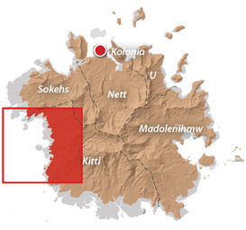
Western Kitti GPS Data
Downloadable GPS Data Files
The following files contain all the packaged GPS data for each of the featured locations in the Western Kitti Eco-Adventure Map Guide.
Three file types are provided. KMZ and KML files are compatible with Google Earth. KML is compatible with Google Maps. GPX files can be imported into ArcGIS (a professional mapping application) and some hand-held GPS devices.
[info]NOTE: All files are free to the public and can be used for any purpose without permission.[/info]
Dolen Uh Hike & Pilen Seleur Eel Pools (2015)
Sahwartik & Sahwarlap Waterfalls Hike (2015)
Six Waterfalls Hike (2015)
Coordinates
The following coordinates correspond with sites featured on the Western Kitti Eco-Adventure Map Guide. It is our dream to eventually create a Pohnpei GPS app that could be uploaded to smartphones and other devices, but for now, these points of interest can be entered manually in a hand-held GPS device as needed.
[info]NOTE: All GPS devices have a margin of error. That margin increases with interference — when there is a thick canopy of trees, during bad weather, or when mountains obstruct the satellite link. The geosynchronous satellites employed when navigating on Pohnpei are located low on the southwestern horizon, such that maintaining a strong connection while hiking on the northeast side of a given mountain range can be difficult. Coordinates on the northeastern slopes of mountains are less accurate than in other locations.[/info]
Coordinates are not yet available for this area. We’re working to get them on-line ASAP. Please check back soon!
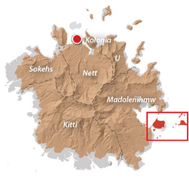
Temwen Vicinity GPS Data
Downloadable GPS Data Files
The following files contain all the packaged GPS data for each of the featured locations in the Temwen Vicinity Eco-Adventure Map Guide.
Three file types are provided. KMZ and KML files are compatible with Google Earth. KML is compatible with Google Maps. GPX files can be imported into ArcGIS (a professional mapping application) and some hand-held GPS devices.
[info]NOTE: All files are free to the public and can be used for any purpose without permission.[/info]
Temwen Island Coastline (2015)
- Temwen Coastline (2015) – temwen-island.kmz (36 kb)
- Temwen Coastline (2015) – temwen-island.gpx (143 kb)
Temwen Island Mangroves (2015)
- Temwen Mangroves (2015) – temwen-mangroves.kmz (298 kb)
- Temwen Mangroves (2015) – temwen-mangroves.gpx (1.3 mb)
Temwen Island Contour Lines (2015)
- Temwen Island Contour Lines (2015) – temwen-contour.kmz (21 kb)
- Temwen Island Contour Lines (2015) – temwen-contour.gpx (78 kb)
Temwen Island Roads (2015)
- Temwen Island Roads (2015) – temwen-roads.kmz (8 kb)
- Temwen Island Roads (2015) – temwen-roads.gpx (24 kb)
Temwen Island Trails & Routes (2015)
- Temwen Island Trails & Routes (2015) – temwen-routes.kmz (13 kb)
- Temwen Island Trails & Routes (2015) – temwen-routes.gpx (49 kb)
Temwen Island Points of Interest (2015)
- Temwen Island Points of Interest (2015) – temwen-places.kmz (33 kb)
- Temwen Island Points of Interest (2015) – temwen-places.gpx (118 kb)
Dolopwuropwur Gun Battery (2015)
Coordinates
The following coordinates correspond with sites featured on the Temwen Vicinity Eco-Adventure Map Guide. It is our dream to eventually create a Pohnpei GPS app that could be uploaded to smartphones and other devices, but for now, these points of interest can be entered manually in a hand-held GPS device as needed.
[info]NOTE: All GPS devices have a margin of error. That margin increases with interference — when there is a thick canopy of trees, during bad weather, or when mountains obstruct the satellite link. The geosynchronous satellites employed when navigating on Pohnpei are located low on the southwestern horizon, such that maintaining a strong connection while hiking on the northeast side of a given mountain range can be difficult. Coordinates on the northeastern slopes of mountains are less accurate than in other locations.[/info]
Temwen Island
| Temwen Causeway South Bridge | —- | 6.843731° 158.313411° |
| Temwen Causeway North Bridge | —- | 6.845294° 158.314911° |
| Peipas Island (Approx. location) | —- | 6.848979° 158.315855° |
| Salong Point | —- | 6.856344° 158.322675° |
| Temwen Elementary School | —- | 6.851509° 158.329239° |
| Current Nahnmwarki’s Residence | —- | 6.851064° 158.332056° |
| Japanese Wharf | —- | 6.855733° 158.332092° |
| Turn-Off to Nan Madol Trail | —- | 6.846941° 158.328562° |
| Nan Madol Trail Parking | —- | 6.845865° 158.330689° |
| Nan Madol Trailhead | —- | 6.844408° 158.330671° |
| End of Temwen Road / Beginning of Footpath | —- | 6.846342° 158.319744° |
| Causeway Store | —- | 6.845268° 158.314783° |
Nan Madol Ruins
| Nan Madol Trailhead | —- | 6.844408° 158.330671° |
| Peinkitel Perimeter Wall North Corner | —- | 6.844326° 158.331118° |
| Peinkitel Entrance | —- | 6.844018° 158.330501° |
| Peinkitel Tomb | —- | 6.844041° 158.330894° |
| Central Peidoh Islet | —- | 6.844092° 158.331846° |
| Sapwohng Islet West Corner | —- | 6.843660° 158.332228° |
| Huge Tree | —- | 6.843828° 158.333042° |
| Central Peilapalap Islet | —- | 6.842964° 158.332899° |
| Central Rasalap Islet | —- | 6.843384° 158.333474° |
| Central Pahseid Islet | —- | 6.843888° 158.333827° |
| Central Usendau Islet | —- | 6.844284° 158.334102° |
| Central Dau Islet | —- | 6.844609° 158.335067° |
| Nan Douwas Islet Entrance | —- | 6.844533° 158.335524° |
| Nan Douwas Islet Sakau Stones | —- | 6.844560° 158.335479° |
| Nan Douwas Islet Sakau Stone | —- | 6.844547° 158.335663° |
| Nan Douwas Islet Central Tomb | —- | 6.844535° 158.335799° |
| Nan Douwas Islet North Tomb | —- | 6.844698° 158.335777° |
| Nan Douwas Islet South Tomb | —- | 6.844390° 158.335724° |
| Central Pohn Douwas Islet | —- | 6.845042° 158.335810° |
| Central Kohnderek Islet | —- | 6.845558° 158.335205° |
| Central Pwalahng Islet | —- | 6.845051° 158.334678° |
| Kahnimweiso Gate (approx.) | —- | 6.843599° 158.337261° |
| Nan Mwoluhsei Sea-wall Entrance | —- | 6.844190° 158.336966° |
| Central Peikapw Sapwawas Islet | —- | 6.843553° 158.334780° |
| Central Pwilak Islet | —- | 6.843159° 158.333909° |
| Central Peinior Islet | —- | 6.842824° 158.334263° |
| Peinering Islet Entrance | —- | 6.842123° 158.333784° |
| Central Perektuhke Islet | —- | 6.841853° 158.332661° |
| Central Pahn Katau Islet | —- | 6.841491° 158.332450° |
| Central Dapahu Islet | —- | 6.842452° 158.332358° |
| Central Usennamw Islet | —- | 6.842585° 158.331411° |
| Central Peitaup Islet | —- | 6.841846° 158.331174° |
| Central Dekehtik Islet | —- | 6.841530° 158.331148° |
| Dorong Islet Perimeter Wall North Corner | —- | 6.840986° 158.329394° |
| Lehnkei (Pool) | —- | 6.840853° 158.331381° |
| Central Peikapw Islet | —- | 6.841907° 158.330170° |
| Idehd Islet Northwest Entrance | —- | 6.841308° 158.330293° |
| Dolen Idehd / Midden | —- | 6.841081° 158.330336° |
| Nan Samwol’s Hole, Idehd | —- | 6.841252° 158.330532° |
| Idehd Islet Northeast Entrance | —- | 6.841288° 158.330555° |
| Isokelekel’s Slingstones, Idehd | —- | 6.841194° 158.330428° |
| Pahn Kadira Islet Sokehs Corner | —- | 6.841195° 158.329971° |
| Pahn Kadira Islet Katau Corner | —- | 6.840766° 158.329374° |
| Pahn Kadira Islet House Foundation | —- | 6.840986° 158.329394° |
| Temple of Nankieilmwahu, Pahn Kadira | —- | 6.841427° 158.329366° |
| Saudeleur’s House Foundation, Pahn Kadira | —- | 6.841484° 158.328948° |
| Pahn Kadira Islet Southwest Entrance | —- | 6.841074° 158.329119° |
| Pahn Kadira Islet Sakau Stone | —- | 6.841186° 158.329195° |
| Pahn Kadira Islet Sakau Stone | —- | 6.841220° 158.329145° |
| Pahn Kadira Islet Sakau Stone | —- | 6.841266° 158.329161° |
| Pahn Kadira Islet Sakau Stone | —- | 6.841305° 158.329112° |
| Pahn Kadira Islet Sakau Stone | —- | 6.841333° 158.329119° |
| Pahn Kadira Islet Madolenihmw (Likapwar) Corner | —- | 6.841558° 158.328740° |
| Pahn Kadira Islet Kitti Corner | —- | 6.842035° 158.329364° |
| Saudeleur’s Bathing Area, Pahn Kadira | —- | 6.841207° 158.329844° |
| Central Pahn Kadira Islet Annex | —- | 6.841268° 158.328655° |
| Central Wasao Islet | —- | 6.841982° 158.328645° |
| Central Reitik Islet | —- | 6.841565° 158.328299° |
| Central Peilam Islet | —- | 6.840527° 158.328599° |
| Central Kelepwel Islet | —- | 6.840592° 158.329081° |
| Central Peinmwek Islet | —- | 6.840670° 158.329624° |
| Central Palakapw Islet | —- | 6.840433° 158.330480° |
| Central Pohnkeimw Islet | —- | 6.840469° 158.326021° |
| Mweiden Kitti (Opening) | —- | 6.839358° 158.327282° |
| Central Pahnmweid Islet | —- | 6.839566° 158.326991° |
| Central Mweid Islet | —- | 6.838856° 158.327817° |
| Boulder Wall, Pahnwi Islet | —- | 6.837491° 158.328793° |
| Upper Pahnwi Islet | —- | 6.838243° 158.329723° |
| Mweiden Weliwel (Opening) | —- | 6.838459° 158.330260° |
| Kepinehd Islet | —- | 6.838917° 158.330884° |
| Mweiden Nahnsapwe (Opening) | —- | 6.839264° 158.331517° |
| Pikalap Islet | —- | 6.839387° 158.331645° |
| Mweidalap (Opening) | —- | 6.839462° 158.331846° |
| Lemensai Islet | —- | 6.839657° 158.331986° |
| Namwenkau (Pool) | —- | 6.839964° 158.332334° |
| Central Lemenkau Islet & Sakau Stones | —- | 6.840380° 158.332956° |
| Lemenkau Islet West Entrance | —- | 6.840332° 158.332482° |
| Pahn Mwasangapw Burial Chamber | —- | 6.841272° 158.334303° |
| Angeir Burial Chamber | —- | 6.841597° 158.334853° |
| Sapwuhtik Burial Chamber | —- | 6.841978° 158.335596° |
| Lukepen Kerian | —- | 6.842601° 158.336477° |
| Kerian Islet Southwest Entrance | —- | 6.842727° 158.336632° |
| Kerian Islet Central Tomb | —- | 6.842821° 158.336771° |
| Kerian Islet North Tomb | —- | 6.842859° 158.336748° |
| Kerian Islet South Tomb | —- | 6.842776° 158.336799° |
| Barge Wreck, Kerian | —- | 6.842461° 158.336651° |
| Huge Sakau Stone, Kerian | —- | 6.842687° 158.336623° |
Dolopwuropwur Battery
| Turn-off to Dolopwuropwur Trailhead | —- | 6.850746° 158.329126° |
| Dolopwuropwur Trailhead | —- | 6.848025° 158.325991° |
| 15 cm Gun #1 | —- | 6.849032° 158.325672° |
| 15 cm Gun #2 | —- | 6.848915° 158.325796° |
| 15 cm Gun #3 | —- | 6.848777° 158.325841° |
| 15 cm Gun #4 | —- | 6.848569° 158.325807° |
| Northern Ammunition Magazine | —- | 6.848901° 158.325669° |
| Southern Ammunition Magazine | —- | 6.848668° 158.325755° |
| Unknown Japanese Foundation | —- | 6.848775° 158.325632° |
| Stone Tower Steps | —- | 6.848635° 158.325571° |
| Japanese Stone Tower | —- | 6.848609° 158.325540° |
| Dug-Out | —- | 6.848583° 158.325497° |
| Japanese Trench North End | —- | 6.848767° 158.325589° |
| Japanese Trench Intersection | —- | 6.848156° 158.324919° |
| Unknown Japanese Structure | —- | 6.848138° 158.325148° |
| Japanese Trench South End / Path Intersection | —- | 6.847964° 158.323712° |
| Cross Island Footpath South End | —- | 6.846107° 158.322737° |
| Cross Island Footpath North End | —- | 6.851214° 158.325296° |
| Dolopwuropwur Peak | —- | 6.848742° 158.325911° |
Around Temwen
| Pohnpei Agriculture & Trade School (PATS) | —- | 6.843103° 158.307976° |
| Marine Environmental Research Institute of Pohnpei (MERIP) | —- | 6.843932° 158.308811° |
| MERIP Apartments | —- | 6.843340° 158.308811° |
| Mwudoketik Island | —- | 6.841213° 158.319636° |
| Mwudokalap Island | —- | 6.839816° 158.317841° |
| Ulidei Island | —- | 6.841085° 158.316101° |
| Dauen Moahk (Channel) West End | —- | 6.845671° 158.314698° |
| Dauen Moahk (Channel) East End | —- | 6.840842° 158.328417° |
| Namwen Nahnningi Stingray Reserve | —- | 6.833504° 158.322414° |
| Nahnningi Island | —- | 6.831781° 158.326057° |
| Mall Island | —- | 6.829152° 158.322269° |
| Nahnningi Snorkeling Pool | —- | 6.828426° 158.326448° |
| Nahnningi Dive Site | —- | 6.826786° 158.324659° |
| Straight Wall Dive Site | —- | 6.832236° 158.334271° |
| Pahn Nahkapw Bridge Dive Site | —- | 6.840180° 158.342650° |
| Kepidauen Nahkapw (Reef Passage) | —- | 6.840793° 158.342252° |
| Nahkapw Island | —- | 6.843777° 158.344200° |
| Pahn Nahkapw Wall Dive Site & Snorkeling | —- | 6.843689° 158.342220° |
| Nipaden Nahkapw Snorkeling Spot | —- | 6.846010° 158.346045° |
| Dekehtik Island | —- | 6.848340° 158.348134° |
| Dekehtik Island Snorkeling Spot | —- | 6.847929° 158.346902° |
| Namwen Na Stingray Reserve | —- | 6.853543° 158.352856° |
| Na North Coast Camping, Swimming & Snorkeling | —- | 6.852748° 158.356608° |
| Nahpali Island | —- | 6.861427° 158.355330° |
| Dekehmwahu Island | —- | 6.860339° 158.359588° |
| Nahpali Island Snorkeling | —- | 6.860600° 158.353214° |
| Nahpali Island Searchlight Drum | —- | 6.862617° 158.356630° |
| Nahpali Island Gun Station #3 | —- | 6.862775° 158.356153° |
| Nahpali Island Gun Station #2 | —- | 6.862848° 158.355992° |
| Nahpali Island Gun Station #1 | —- | 6.862914° 158.355861° |
| Nahpali Island Japanes Coastal Foundation | —- | 6.862591° 158.355395° |
| Nahpali Island Beach | —- | 6.862192° 158.354946° |
| Nahpali Island Beach | —- | 6.863028° 158.355964° |
| Nahpali Island Japanese Coastal Foundation | —- | 6.862075° 158.354758° |
| Nahpali Island Japanese Diesel Engine | —- | 6.861961° 158.354814° |
| Nahpali Island Japanese Foundations | —- | 6.861690° 158.354699° |
| Nahpali Island Japanese Foundation | —- | 6.861393° 158.354617° |
| Nahpali Island Japanese Water Tank | —- | 6.861250° 158.354561° |
| Nahpali Island Japanese Coastal Water Tank | —- | 6.861402° 158.354411° |
| Nahpali Island Gateway Tree | —- | 6.861229° 158.354377° |
| Nahpali Island Japanese Cistern | —- | 6.861601° 158.354808° |
| Dekehmwahu Beach | —- | 6.861424° 158.359777° |
| Na Dive Site | —- | 6.846678° 158.365113° |
| Nanwap Corner Dive Site | —- | 6.871079° 158.356093° |
| Kepidauen Deleur (Reef Passage) | —- | 6.863361° 158.343756° |
| Madolenihmw Bay | —- | 6.861248° 158.306274° |
| Nahpali Surf Break | —- | 6.867134° 158.361762° |
| Nan Madol (Kepidauen Nahkapw) Surf Break | —- | 6.839137° 158.340387° |
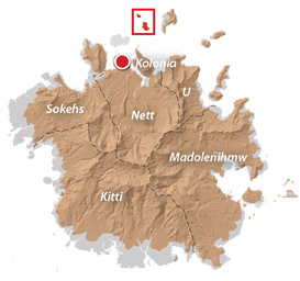
Lenger Island GPS Data
Downloadable GPS Data Files
The following files contain all the packaged GPS data for the Lenger Island Eco-Adventure Map Guide, including the island’s coastline, ocean depth info, ten meter contour lines, mangrove forests, roads and trails, land divisions, World War II features, modern features, and other points of interest.
Three file types are provided. KMZ and KML files are compatible with Google Earth. KML is compatible with Google Maps. GPX files can be imported into ArcGIS (a professional mapping application) and some hand-held GPS devices.
[info]NOTE: All files are free to the public and can be used for any purpose without permission.[/info]
Lenger Island (2016)
Coordinates
The following coordinates correspond with sites featured on the Lenger Island Eco-Adventure Map Guide. It is our dream to eventually create a Pohnpei GPS app that could be uploaded to smartphones and other devices, but for now, these points of interest can be entered manually in a hand-held GPS device as needed.
[info]NOTE: All GPS devices have a margin of error. That margin increases with interference — when there is a thick canopy of trees, during bad weather, or when mountains obstruct the satellite link. The geosynchronous satellites employed when navigating on Pohnpei are located low on the southwestern horizon, such that maintaining a strong connection while hiking on the northeast side of a given mountain range can be difficult. Coordinates on the northeastern slopes of mountains are less accurate than in other locations.[/info]
Southwestern Lenger
| Barbosa’s Wharf | —- | 6.993799° 158.228531° |
| Former Barbosa Resort Site | —- | 6.994306° 158.229159° |
| Japanese Coastal Warehouse Foundation | —- | 6.994406° 158.229708° |
| Japanese Underground Crude Oil Complex Trailhead | —- | 6.994717° 158.229517° |
| Gate 1 – Crude Oil Complex | —- | 6.995515° 158.230239° |
| Japanese Storage Caves Trailhead | —- | 6.993890° 158.230359° |
| Japanese Concrete Plant Trailhead | —- | 6.994275° 158.230646° |
| Japanese Concrete Plant Equipment | —- | 6.994502° 158.230447° |
| Ballast Hill | —- | 6.994418° 158.230380° |
| Japanese Cave 1 | —- | 6.994567° 158.231047° |
| Japanese Cave 2 | —- | 6.994792° 158.230931° |
| Japanese Cave 3 | —- | 6.994894° 158.230736° |
| Japanese Cave 4 | —- | 6.994950° 158.230661° |
| Japanese Above-Ground Oil Tank | —- | 6.993772° 158.230847° |
| Japanese Above-Ground Oil Tank Foundation | —- | 6.993894° 158.230716° |
| Path Intersection Point | —- | 6.993445° 158.230835° |
Southern Lenger
| Japanese Machine Parts | —- | 6.993100° 158.231317° |
| Japanese Square Cistern | —- | 6.993406° 158.231139° |
| Japanese Aviation Fuel Tank Trailhead | —- | 6.993896° 158.231492° |
| Japanese Aviation Fuel Tank Tunnel Gate | —- | 6.994211° 158.231342° |
| Japanese Rectangular Cistern | —- | 6.994006° 158.231840° |
| Japanese Machinery & Wheels | —- | 6.993628° 158.231561° |
Eastern Lenger
| Stream Crossing | —- | 6.995612° 158.232389° |
| Banyan Wheel | —- | 6.996089° 158.232106° |
| Dolen Lenger Trailhead (Eastern Route) | —- | 6.995896° 158.232360° |
Northeastern Lenger
| Japanese Seaplane Hangar Ruin | —- | 6.997648° 158.232069° |
| Compressor | —- | 6.997654° 158.232009° |
| Japanese Seaplane Strut | —- | 6.997610° 158.231969° |
| Japanese Seaplane Engine & Prop | —- | 6.997646° 158.231922° |
| Japanese Seaplane Carriers | —- | 6.997317° 158.231503° |
| Japanese Seaplane Ramp Trailhead | —- | 6.998005° 158.231864° |
| Japanese Seaplane Ramp | —- | 6.999088° 158.233040° |
Northern Lenger
| Well | —- | 6.998180° 158.231401° |
| Bomb Craters | —- | 6.998240° 158.230883° |
Western Lenger
| Japanese Coastal Barracks Site | —- | 6.996593° 158.228989° |
| Japanese Coastal Barracks Site | —- | 6.997418° 158.228861° |
| Dolen Lenger Trailhead Western Route A | —- | 6.997555° 158.229206° |
| Dolen Lenger Trailhead Western Route B | —- | 6.997874° 158.229242° |
Central Lenger (Hill Area)
| Intersection of Japanese Hill Roads | —- | 6.997592° 158.230367° |
| Tunnel Entrance | —- | 6.997431° 158.230122° |
| Japanese Dug-out 1 | —- | 6.997294° 158.230053° |
| Japanese Dug-out 2 | —- | 6.997325° 158.230153° |
| Japanese Gatepost | —- | 6.997197° 158.230789° |
| Dolen Lenger Japanese Cistern 1 | —- | 6.996967° 158.230894° |
| Cement Steps | —- | 6.996908° 158.230919° |
| Japanese Coastal Battery Trailhead | —- | 6.996659° 158.230743° |
| 15-cm Gun Station 3 | —- | 6.996673° 158.230400° |
| 15-cm Gun Station 4 | —- | 6.996549° 158.230341° |
| 15-cm Gun 4 | —- | 6.996589° 158.230353° |
| Japanese Heavy Ordnance Magazine | —- | 6.996374° 158.230300° |
| Japanese Searchlight Drum | —- | 6.996547° 158.230692° |
| Searchlight Mount | —- | 6.996547° 158.230644° |
| Well | —- | 6.996164° 158.230914° |
| Small Japanese Gun Station | —- | 6.996278° 158.230736° |
| Japanese Anti-Aircraft Gun Station 1 | —- | 6.996000° 158.230706° |
| Cliff-Top Viewpoint | —- | 6.995681° 158.230625° |
| Japanese Anti-Aircraft Gun Station 2 | —- | 6.995547° 158.230878° |
| Cliff-top Viewpoint | —- | 6.995256° 158.231036° |
| Dolen Lenger Summit | —- | 6.995211° 158.231133° |
| Tunnel Entrance | —- | 6.996831° 158.230875° |
| Japanese Hillslope Barracks Foundations | —- | 6.996666° 158.231196° |
| Dolen Lenger Japanese Cistern | —- | 6.996650° 158.231408° |
| Japanese Diesel Engines | —- | 6.996544° 158.231369° |
| Japanese Catchments | —- | 6.996519° 158.231397° |
Around Lenger Island
| Mangrove Channel – North End | —- | 6.994655° 158.233077° |
| Mangrove Channel – South End | —- | 6.992055° 158.232919° |
| Kohatsu Wharf Ruin | —- | 6.991614° 158.232224° |
| Jaluit Cistern | —- | 6.994608° 158.227631° |
Central Sapwtik
| Sapwtik Island Japanese Wharf | —- | 7.002000° 158.223916° |
| Coastal Path Intersection Point | —- | 7.004462° 158.224978° |
| Ascent to Dolen Sapwtik | —- | 7.004270° 158.225460° |
| Japanese Hilltop Wall | —- | 7.004401° 158.225972° |
| Dolen Sapwtik Summit | —- | 7.004317° 158.226247° |
| Japanese Hilltop Foundation 1 | —- | 7.004372° 158.226264° |
| Japanese Hilltop Foundation 2 | —- | 7.004531° 158.226044° |
| Japanese Hilltop Foundation 3 | —- | 7.004643° 158.225894° |
| Great Banyan | —- | 7.004788° 158.225917° |
| Japanese Hilltop Cistern 1 | —- | 7.004421° 158.226434° |
| Japanese Hilltop Cistern 2 | —- | 7.004567° 158.226193° |
Western Sapwtik
| Japanese Heavy Ordnance Magazine | —- | 7.005594° 158.224468° |
| Japanese Coastal Gun Station 1 | —- | 7.005850° 158.224329° |
| Japanese Coastal Gun Station 2 | —- | 7.005976° 158.224384° |
| Japanese Coastal Gun Station 3 | —- | 7.006085° 158.224460° |
| Japanese Coastal Gun Station 4 | —- | 7.006203° 158.224497° |
Northern Sapwtik
| Japanese Hillside Rifle Pit | —- | 7.005679° 158.224880° |
Sapwtakai and Other Prehistoric Cultural Sites & Ruins
Prehistoric Sites & Ruins in Kitti
[tabs]
[tab title=”Sapwtakai”]
The Fortress of Sapwtakai
Sapwtakai (“rock land”) is a 13,000 m2 stone complex that crowns a hill north of Wenik. The site was first occupied around 1250 A.D. and functioned as a political center for at least four centuries. The walls, terrace platforms, stone-paved walkways, tombs, and other features were built in three phases. The upper portion of the fortress was the residential area, while the southern part was the ceremonial center.
The wall on the north side of Sapwtakai is higher than at other points — presumably to deter enemies from that direction, while the steep slope on the east side offers natural protection. About 15 meters north of the complex perimeter is another free-standing 1.5 to 2 meter high wall that runs south and east. These defensive structures failed, however, to protect the fortress from incursions by the Dipwinpehpe clan, which took control of Pehleng and then moved south, driving out the Soukitti clan and conquering Sapwtakai. The fortress was occupied for a period of time, during which the Dipwinpehpe destroyed some of its features. Neighboring Onohnleng eventually decided that the need to regain power over the region justified open war. The main force of warriors were sent marching north from Lukoap. At the same time, a fleet of canoes was assembled off the coast. But instead of containing more fighting men, the canoes carried dummies. The Dipwinpehpe saw what Onohnleng wanted them to — two separate forces set against them. They divided their own army to deal with both the men on land and the fleet, only to find that they’d been tricked. The divided army was soon defeated by the men of Onohnleng, Sapwtakai was retaken, and the regions that now make up Kitti were united under centralized leadership for the first time.
Sapwtakai continued to be utilized for some time after the unification of Kitti, but was abandoned around 1850. Other than a meticulous archaeological survey by Joyce Bath in 1980, the ruin has mostly been left to time and nature — rarely visited and entirely unmanaged by Pohnpei State and the Historic Preservation Office. A lot of the hill has been overgrown by wild hibiscus, durien, and hellishly stickery wild yam vines with spines that will go right through the soles of booties or FiveFingers. There is still much to see, but it’s imperative that one finds a good guide who knows the site well.
Points of interest include boulder walls as tall as 2 meters beyond the northern perimeter, a platform of tabular basalt in the northern corner that rises 2 meters above the wall, several 450-year-old house platforms with central fire pits, breadfruit storage pits, a large burial complex constructed of basalt boulders and prisms and containing two openings leading to a central crypt, a contemporary Japanese slit trench, a 2-tiered platform with a central fire pit where hammer stones for pounding sakau were discovered, and seven river cobbles that are said to be magical sling stones.
[/tab]
[tab title=”Kitti Rock Area Sites”]
“Kitti Rock” Area Ruins
The cluster of ruins on the slope below Sapwtakai were referred to as “Kitti Rock” by archaeologists because a basalt stone from Nan Madol was placed in the area when Kitti was founded. There are many sites. We’ve highlighted only a few here.
Dolomar Paiei (Site 35-26)
This is a two-tiered stone platform in Sapwtakai district with terraces on two sides.
Dolomar Pailong (Site 35-14)
This is a stone platform southwest of the Sapwtakai ruins.
Peidolenmai (Site 32-8)
Peidolenmai (“stone platform of the hill of breadfruit”) is a 3 x 4.5 meter stone platform in Alauso with two breadfruit storage pits inside the enclosure. The pits and the name indicate the purpose of the site.
Peinkareraua (Site 35-17)
Peinkareraua is a stone platform with an enclosing wall 2 meters thick and two low platforms that together formed the residence of the ruler of Kepihleng and the center of state ceremonial events, located southwest of Sapwtakai ruins in Sapwtakai district.
There are many access points for these ruins. It’s possible to cut southwest from Sapwtakai and find oneself in the midst of the highest concentration of the “Kitti Rock” sites, but trails also run from Nanmand, Marahu, and Seinwar. Ask around for guides at houses in those areas.
[/tab]
[tab title=”Diadi & Wenik Sites”]
Diadi & Wenik Sites
“Dolen Samaki” (Site 30-18)
This is a stone enclosure on an 86 meter hill in Wenik district, identified by the name of the hill on which it is found. At the site is a huge magical boulder (takai wek mai) that was used in combination with a spell to ensure a good breadfruit harvest. There are also three other large boulders with special properties. The site is mentioned in the oral history of Utin Iap, the “banana of Yap”.
Pahn Kipar (Site 30-19)
Pahn Kipar is a 5 x 6 meter stone terrace platform with an extended breadfruit storage pit in Wenik district.
Peinmwas (Site 30-20)
Peinmwas (“stone platform of the worm”) is a stone platform, now mostly buried or scattered, between Wenik and Diadi districts. The site is mentioned in the Utin Iap (“banana of Yap”) oral history.
Pohn Kohla (Site 27-3)
This 13 x 15 meter rock platform and stone-paved terrace is located between Wenik and Diadi districts on the southern slope of a hill. The location has two peitehl (sakau stones) and an uhmw (rock oven) site.
The most direct access point for these sites is at Oare, but it’s also possible to reach them via trails beginning opposite the Kitti SDA Church. Ask around for guides at houses and stores in either of these locations.
[/tab]
[tab title=”Seinwar Sites”]
Seinwar Area Sites
Niahlek (Site 34-29)
This is a single 5 x 6 meter stone platform with a central pit located in Seinwar district.
Soaid (Site 34-32)
This stone burial platform is found in Seinwar district on the hillside above the Circle Island Road.
It’s possible to find people in Seinwar who can lead visitors southeast past Soaid, Niahlek, and other sites in this vicinity. Ask around at houses and stores along the main road.
[/tab]
[tab title=”Pan Pei, Alauso, Poatoapoat & Wenik Sites”]
Pan Pei, Alauso, Poatoapoat & Wenik Area Sites
Narong (Site 31-17)
This is a semi-circular stone terrace platform with a large shell midden, where a number of artifacts — including a breadfruit pounding stone, hammer stone, and coral grinding stone used to make breadfruit peelers from cowrie shells — were found. Breadfruit was prepared at this place for preservation in pits. The site is located in Poatopoat district.
Pan Pei
About 680 meters southwest of Sapwtakai and 400 meters northeast of the Kitti Municipal Office are the structures of Pan Pei. The primary feature in the group is a 169 m2 burial platform built of prismatic basalt columns and containing four crypts. The platform is about 1 meter high. At one point in the past the crypts were roofed with columns. A road 25 meters south of the Municipal Office leads up into the hills, passing several of the Poatoapoat sites and connecting with a footpath that runs north to the Pan Pei sites before ending at a residence. From the residence, another footpath goes southeast to the top of a hill where the Japanese had an anti-aircraft gun installed (the gun is not there now).
“Pilen Koaroan” (Site 35-19)
“Pilen Koaroan” consists of three stone structures, including a double vault tomb attached to a wall and a stepped platform with a central pit. It’s part of the “Pan Pei” group.
“Diadi” (Site 30-16)
This is a single 9 x 11 meter stone platform surrounded by a wall and identified by the name of the district in which it lies. The area is marshy. The wall ranges from a half meter to a meter in height and has a single entrance about a meter wide, while the central pit is little less than a square meter and a third of a meter deep. “Diadi” is also unique because the walls consist of boulders, flat stones, and oblong basalt prisms mixed together.
Site 30-17
This is a stone ruin in Diadi district just below the peak of a hill and nearby the “Diadi” ruin.
For these sites, ask at and around the Kitti Municipal Office for a guide.
[/tab]
[tab title=”Salapwuk Sites”]
Salapwuk Area Sites
Elen Eni
Elen Eni (“ghost path”) is the sacred burial site of a number of traditional high priests, called soumw. These priests were instrumental in the religious cult that thrived in Salapwuk prior to the conquest of Christian missionaries. Many Pohnpeians are afraid of the site and would never go there or consider taking a foreigner there, but there are some guides who would be willing to make a visit if certain ground-rules are followed.
Lehn Mwahmw
Lehn Mwahmw (“fish pool”) is a natural pool on the Lehnmesi River rather than a man-made site. Located in Salapwuk district, the pool is believed to be a spot that Pohnpei’s early settlers stocked with fish upon arrival.
Lehnpoudek
Lehnpoudek (“mooring pool”) is another natural pool on the Lehnmesi. Myth suggests that Pohnpei’s founder, Sapwkini, and his entourage moored their canoes at this spot.
“Rasalap” (Site 24-7)
This is a 10 x 14 meter stone complex (141 m2), consisting of boulders stacked to form two low platforms separated by a wall and enclosed in a meter high perimeter wall. Once again, the name actually refers to the area — a huge, marshy savannah and fern meadow on a hill west of Salapwuk district — rather than to the structure itself. The most unusual aspect of the site is the dual courtyards — a feature atypical in prehistoric Pohnpeian architecture. The site’s purpose is not clear.
Sokosoken Leng
In the forest off the west side of the road past Salapwuk Elementary School is a basalt boulder with a coralhead on top. Sokosoken Leng (“landing of heaven”) and its stone marks the spot where Pohnpei’s mythical founder, Sapwkini, first docked his voyaging canoe and later began to build Pohnpei on the reef, using magic to pile up rocks and earth to form an island.
Takain Pwohng
Takain Pwohng (“stone of night”) is a trio of boulders along the Lehnmesi River, where one high priest (soumw) of the Salapwuk religious cult was said to have lived in ancient times, allegedly performing human sacrifices and ritual cannibalism at a small cave under the largest rock.
The best point of contact for the Salapwuk sites is Welten Panuel. If Welten cannot take you himself, he will be able to recommend a guide for most or all of the Salapwuk area sites. Visit the Guides & Tour Operators page for contact info.
[/tab]
[/tabs]