
Sokehs Island GPS Data
Downloadable GPS Data Files
The following files contain all the packaged GPS data for each of the featured locations in Sokehs Island.
Three file types are provided. KMZ and KML files are compatible with Google Earth. KML is compatible with Google Maps. GPX files can be imported into ArcGIS (a professional mapping application) and some hand-held GPS devices.
[info]NOTE: All files are free to the public and can be used for any purpose without permission.[/info]
[warning]Google Earth imagery exhibits some scaling errors in this sector (i.e. the GPS track, which was checked multiple times with multiple devices, does not line up with the imagery for the primary road leading up Sokehs Mountain). We are confident that our data is as accurate as possible and that some of the aerial images on Google Earth are incorrectly positioned.[/warning]
Sokehs Island (2013) – All destinations and landmarks
Coordinates
The following coordinates correspond with sites featured on the Sokehs Island Eco-Adventure Map Guide. It is our dream to eventually create a Pohnpei GPS app that could be uploaded to smartphones and other devices, but for now, these points of interest can be entered manually in a hand-held GPS device as needed.
[info]NOTE: All GPS devices have a margin of error. That margin increases with interference — when there is a thick canopy of trees, during bad weather, or when mountains obstruct the satellite link. The geosynchronous satellites employed when navigating on Pohnpei are located low on the southwestern horizon, such that maintaining a strong connection while hiking on the northeast side of a given mountain range can be difficult. Coordinates on the northeastern slopes of mountains are less accurate than in other locations.[/info]
| Sokehs Ridge Trailhead / Parking A | —- | 6.961462° 158.195136° |
| Overlook / Parking B | —- | 6.967450° 158.191733° |
| Japanese Stone Wall | —- | 6.963677° 158.191191° |
| Japanese Foundation | —- | 6.963862° 158.191156° |
| Japanese Lookout Post | —- | 6.963977° 158.190538° |
| Japanese Personnel Tunnel | —- | 6.964164° 158.190475° |
| 12.7 cm Anti-Aircraft Gun 1 | —- | 6.964264° 158.190400° |
| 12.7 cm Anti-Aircraft Gun 2 | —- | 6.964161° 158.190933° |
| Japanese Command Post Entrance | —- | 6.963936° 158.190680° |
| Japanese Command Post Foundations | —- | 6.964045° 158.190628° |
| Japanese Concrete Stairs | —- | 6.963892° 158.190686° |
| Japanese Barracks Foundations | —- | 6.963401° 158.190810° |
| Japanese Stove | —- | 6.963339° 158.190848° |
| Japanese Concrete Cistern | —- | 6.963368° 158.190658° |
| 15 cm Coastal Gun & Bunker | —- | 6.962280° 158.189922° |
| Japanese Rifle Pits | —- | 6.966399° 158.189686° |
| Japanese Defensive Trench & Monument | —- | 6.969568° 158.189515° |
| Dollap Summit | —- | 6.969504° 158.189671° |
Sokehs Rock (Paipalap)
| Sokehs Rock Trailhead | —- | 6.977449° 158.193532° |
| Rock Formations / Bouldering Location | —- | 6.977236° 158.191589° |
| Tree Cliff | —- | 6.976622° 158.190800° |
| Rear Foot, Sokehs Rock | —- | 6.976828° 158.190633° |
| The Spire | —- | 6.976230° 158.190944° |
| The Adam’s Apple | —- | 6.975772° 158.190901° |
| Sokehs Rock Summit | —- | 6.978172° 158.190044° |
Kepindau & Pohn Pillap Waterfalls
| Eel Pool, Kepindau | —- | 6.976746° 158.185047° |
| Kepindau Falls Trailhead | —- | 6.976732° 158.184887° |
| Kepindau Falls | —- | 6.974786° 158.185720° |
| Pohn Pillap Falls Trailhead | —- | 6.976320° 158.183070° |
| Pohn Pillap Falls | —- | 6.975267° 158.182845° |
Around Sokehs Island
| Sokehs Municipal Office | —- | 6.958175° 158.194753° |
| Mwalok A-1 Store | —- | 6.968211° 158.196875° |
| Mwalok Community | —- | 6.968740° 158.196965° |
| Mwalok Congregationalist Church | —- | 6.969022° 158.196926° |
| Danipei Community | —- | 6.978790° 158.192938° |
| Danipei United Church of Christ | —- | 6.978364° 158.193000° |
| Historic Preservation Office Nahs | —- | 6.979906° 158.193745° |
| Portage Point | —- | 6.980388° 158.194301° |
| German Road A East End | —- | 6.979963° 158.191738° |
| German Road A West End | —- | 6.980274° 158.190965° |
| German Road B East End | —- | 6.980830° 158.189582° |
| German Road B West End | —- | 6.981042° 158.188068° |
| Nan Imwinsapw Picnic Area | —- | 6.981113° 158.188154° |
| Plateau Road North End | —- | 6.977893° 158.181932° |
| APSCO Quarry Office | —- | 6.980230° 158.181378° |
| The Doldrums Swimming Spot | —- | 6.983199° 158.176991° |
| Roie Church | —- | 6.970795° 158.176375° |
| Sokehs Pah Launch | —- | 6.969430° 158.176897° |
| Sokehs Pah Volleyball Court | —- | 6.964280° 158.183795° |
| Plateau Road South End | —- | 6.962296° 158.184584° |
| Sokehs Pah Basketball Court | —- | 6.955223° 158.189363° |
| St. Peter’s Launch | —- | 6.956975° 158.196907° |
| Sokehs Island Turn-off | —- | 6.956358° 158.198737° |
| Sokehs Island Bridge | —- | 6.957245° 158.195640° |
| Daumwoakote (Channel) East End | —- | 6.954688° 158.194789° |
| Daumwoakote (Channel) West End | —- | 6.953596° 158.181093° |
| The Labyrinth | —- | 6.951691° 158.177859° |
Kepindau & Pohn Pillap Waterfalls
![]()
![]()
![]()
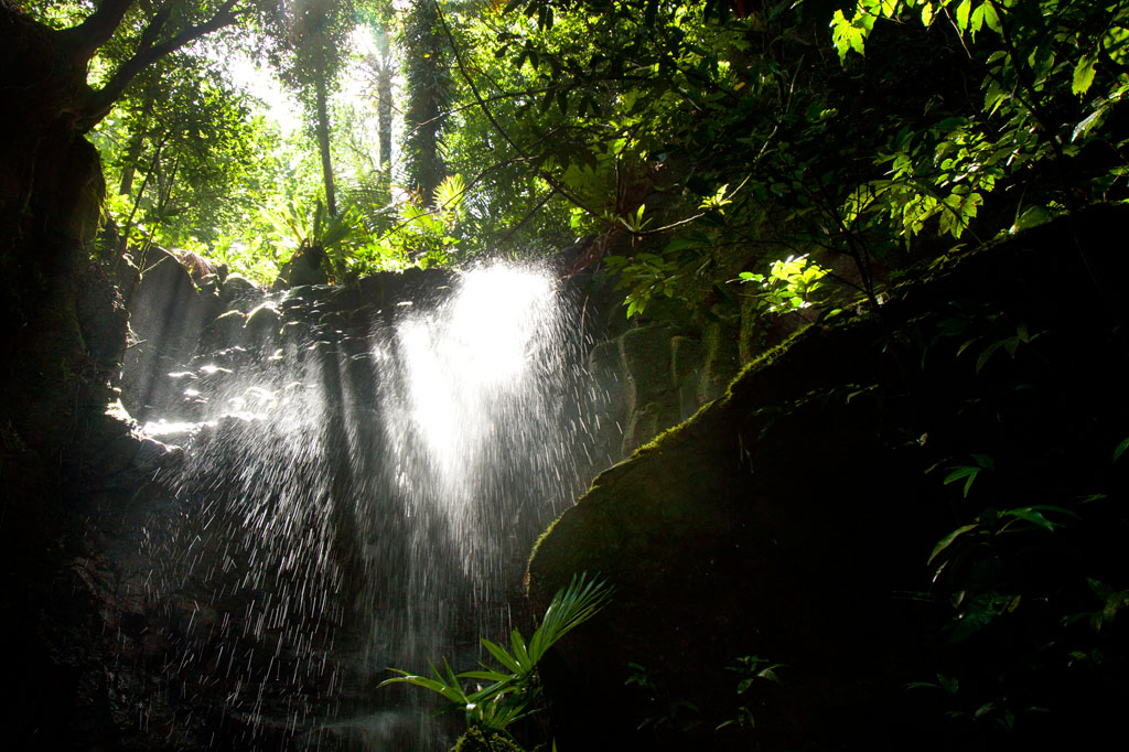
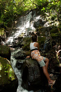
Kepindau Waterfall
The larger of two small waterfalls found on Sokehs Island (the only waterfalls not on the main island of Pohnpei) is known as Kepindau and is located in Tamwarohi Kousapw on the private land of Joe Ferdinand and Dahkar Soulik. The stream and the area around it are also called by the same name, which means “bottom of the mangrove passage”. Kepindau and Pohn Pillap, the next stream to the west, were said to have been created when a giant eel wriggled up the hillside. Freshwater short-fin eels are sacred to Pohnpeians and play a recurring role in local myths; this particular story is just one entry in a greater eel-centric epic. Eels do indeed dwell in Kepindau and are protected and fed by the Ferdinand family. There’s a small pool just below the family’s cookhouse, where the eels can be observed. Bring some canned mackerel and the family will feed the beasts for your entertainment.
The hike follows footpaths that the family members use to get around on their land, climbing more or less straight up the slope on the west side of the stream. The waterfall is in a little rocky alcove that gets some very dramatic light in the morning hours. There is a shallow pool, but the amount of water varies. The best time to visit is a day or so after a period of heavy rain.
Pohn Pillap Waterfall
The second falls, Pohn Pillap, is found just over the border of Ipwal Kousapw on the land of Tony Martin and family. The name means “over the river.” Pohn Pillap is not as visually dramatic as Kepindau, but has a certain ambiance when there’s a lot of water (though there’s no pool here). Martin, who used to work for the Office of Historic Preservation, is extremely knowledgeable about just about everything Pohnpeian and can provide you with many fascinating tidbits about this site and others on Sokehs Island and beyond. He can also arrange for one of his older children to take you up to the falls if he doesn’t feel like guiding you himself. Offer $6-10.00 per group of five people or less.