
Dolen Nett / Pohnlehr
![]()
![]()
![]()
![]()
![]()
Dolen Nett (“hill of Nett”) is a steep-sided mountain running the length of the Nett Point peninsula. Leaf-shaped, this peninsula juts north into the lagoon east of Kolonia and is said, in myth, to have been formed by the corpse of the same monster eel that founded the Lasialap clan, created Lipwentiak, and lived in the Lehdau River for many years. When the creature finally died, her carcass became Dolen Nett.
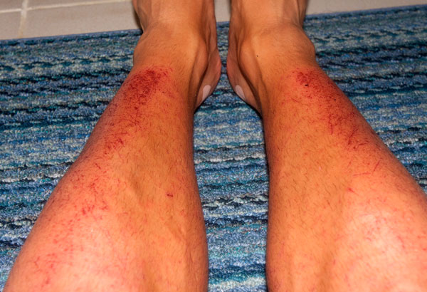
Like Sokehs Mountain, Dolen Nett is mostly flat on top, as if the peak was sliced off. From town, this plateau — known as Pohn Dolen Nett (“on the hill of Nett“) — looks like a manicured lawn, which has inspired the mistaken belief that it was once used as an airfield by the Japanese. In truth, there were only three Japanese airstrips on Pohnpei: one at Nanpohnmal, one in Palikir that never became fully operational, and the seaplane base on Lenger Island. There are hardwood forests around the edges of the plateau, but the central landscape of Pohn Dolen Nett is nearly treeless. Most of this open terrain consists of very resistant, and in many places, shoulder-high paddle grass and Dicranopteris ferns with swampy mires and sections of jagged basalt scattered throughout. It should be noted that the aforementioned ferns can be brutal on bare legs if you’re forcing your way through them for any length of time. That’s cat o’ nine tails brutal. Flay the flesh right off your shinbones brutal. We learned the hard way once, while mapping the location. One humble suggestion: hike in pants. Heat-stroke, too, can be an issue on the hill; with so little tree-cover, sunny days are blistering.
Japanese World War II Sites
As is true of all the high points around Pohnpei’s coasts, the Japanese fortified Dolen Nett in the late 1930s, anticipating an eventual attack by Allied forces (which came in the form of intense bombing raids rather than the expected surface-based assault). The most interesting war features are grouped together at the southern end near the true summit (an area called Pohnlehr) and include some steel drums, the barrel of a disassembled 75 mm canon lying in the woods, rock walls, two stone machine gun pillboxes, and a concrete and steel bunker that houses a second 75 mm gun in situ. To access the latter, which has excellent views of the bay between Nett and Awak, you have to move along a precipice, often partially or completely obscured by high grass. Let your guide go first to clear a path — unless you want to find yourself plummeting through empty space. The bunker itself can be entered, but it’s a bit of a grubby venture as the roof has partially collapsed and is now supported by the breech of the gun itself.
The other major site on the south side is a mobile radar array that sits on a low stone platform in the woods about 126 meters (138 yd) northwest of the gun bunker. The radar was mounted on a rotating turret in the center of a truck chassis (still intact) and the operator turned a wheel to position it. There are some large depressions in the surrounding forests that may be bomb craters, but none of the major features on the hill appear to have sustained direct damage from the bombing runs. More likely, these posts were simply abandoned, as they would not have been very effective against an aerial attack.
The woods pick up again on the north end of the mountain, and here, also, are some Japanese military features, including a large network of narrow defensive trenches, a few stone rifle pits, and machine gun emplacements.
Featured Routes
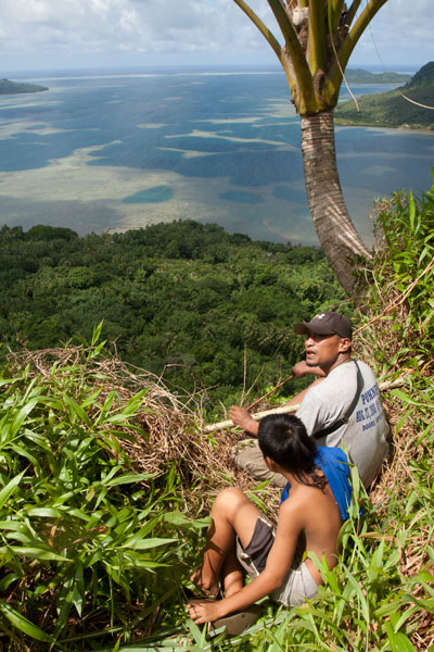
There are many ways to get to the top of Dolen Nett. We have covered four routes on the Greater Nett & Western U Eco-Adventure Map.
(1) The most practical route starts behind a house next to the road in Weipowe 1.2 km (0.75 mi) south of the Nett Point turn-off. Just ask at the houses on the inland side of the road for guides. The trail is well-maintained as far as the family’s private sakau (kava) and yam plantations on the slope. The steepest bit of the climb is at the beginning — 0.4 km / 0.26 mi, 33% slope avg. Near the top of the ridge, the trail passes the entrance to a long Japanese tunnel, well worth exploring — but bring a headlamp. From there, it continues up the forested slope and eventually comes to the open fern meadows, called nanmal (0.4 km / 0.3 mi, 22% slope avg).
(2) Another trail begins 0.6 km (0.37 mi) south of Trailhead 1 (look for a narrow concrete driveway next to a giant mango tree). This may have been the primary Japanese trail, but it is now difficult to follow above the point where farmers plant their sakau. About 0.56 km (0.35 mi) along (26% slope avg), the trail collides with an impassable basalt wall over which a thin waterfall can form after heavy rain. Here the trail turns south and continues about 0.29 km (0.18 mi) with a 17% slope avg, running parallel to the wall until it ends. Then it begins to climb again, briefly emerges in a small meadow, passes through some light forest, and emerges again at a rare grove of coconut palms (185 m / 202 yd).
(3) A third route begins at the edge of the road in Paliais 0.7 km (0.43 mi) north of the Dausokele Bridge. The route is about 0.7 km (0.43 mi) to the top with a 26% slope avg.
(4) The fourth route starts on the edge of the road 1 km (0.62 mi) south of the Nett Point turn-off. It climbs fairly straight 0.27 km (0.17 mi) with an 18% slope avg up to the ridge, which is much lower here. It then turns south and follows the ridge 0.43 km (0.27 mi) until it connects with Route 1 at the Japanese tunnel entrance.
Pohnpei Short-Eared Owl
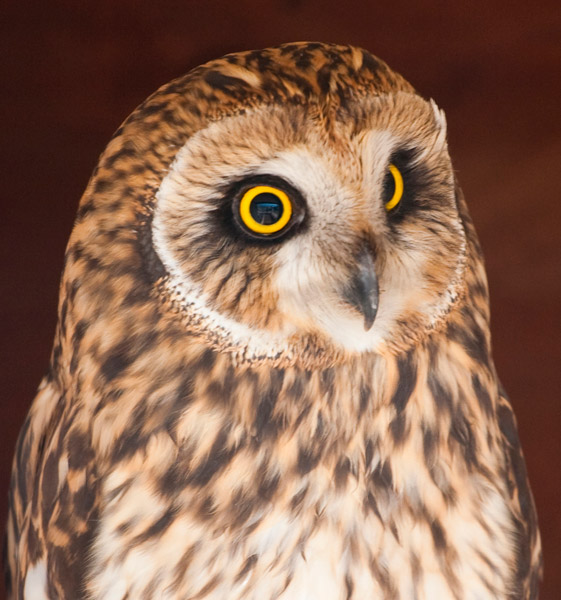
The lonely meadows and forests on the mountaintop are prime habitat for Pohnpei’s shy short-eared owl, Asio flammeus. This species has been pushed up to the mountainsides by building projects — such as the State Hospital — which destroyed its native grasslands habitat. Late afternoon is a good time to look for the large bird rising from its hidden abode as it sweeps out to hunt (we spotted it on three out of five trips).
Camping
There are many fine places to camp on Dolen Nett. The nanmal is excellent on clear nights, where you can gaze both on the star field above and the twinkling lights of Kolonia below. If you want more cover or perhaps some trees to tie a tarp or hammock to, try the forests at the southern end. Bring plenty of water — none is found on the mountaintop — and take everything you brought with you when you leave. A good campsite is one that leaves no trace.
- Plan for 6-8 hours for this hike, if you want to see all the WWII features.
- Please visit the Local Guides & Tour Operators page for a list of experienced guides available for hikes to Dolen Nett. Offer $37-50.00 for a group of five or less.
The Story of the Eel of Pahdol
A long time ago, a couple from Wene came to live in a place called Iro. One day there was a great storm and the heavy rains resulted in a huge flood. Two women in the area went out to fish in the flood, and while they were fishing, a starling flew over and dropped a small stone. The women took the stone home and gave it to the couple from Wene. Later, at a place called Pahnkipar (“under the pandanus tree”), the stone broke apart and from it was hatched a tiny freshwater eel. The couple kept the eel as their pet and allowed it to live in a pool at Pahdol (“under the hill”) in Pahnais. When the eel grew up, however, it began to act in sinister ways. At night, the eel would escape from its pool and sneak into the house, where it would stare at the sleeping couple. The couple became uncomfortable and decided to kill and eat the eel, but the eel overheard their plan, came into the house, and attacked them. The couple fled into the forest and hid under a huge rock, where they believed they’d be safe. The eel discovered the hiding place and ambushed the couple, devouring them alive.
The eel then traveled into the Nanmeir Valley in Pohnpei’s interior and followed the Lehnmesi River source. There she met Kiroun Meir, a high-titled man, who brought her to live with him at his home. The two became lovers and the eel was impregnated. She was restless, however, and departed, continuing to follow the river. At Lipwentiak, the eel encountered a hunter named Kiroun Mand, killing and eating eels. Recoiling at this sight, she created a sharp turn in the river with the writhing of her body. Soon after, she gave birth to her first daughter, the matriarch of the Sounlipwentiak subclan. She had other children later who became the founders of the Lasiadohng (“eels of the dohng tree”) and Lasiakotop (“eels of the kotop palm”) subclans. After that, the eel went to live in Dauen Sapwalap, where she terrorized the local inhabitants, devouring so many that the land became mostly deserted. When the monster finally died, her body formed Dolen Nett.