

Pahn Sile Waterfall
![]()
![]()
![]()
![]()
![]()
![]()
![]()
![]()
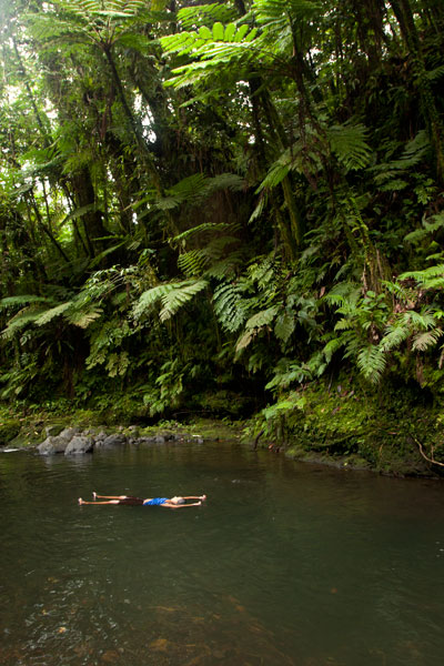
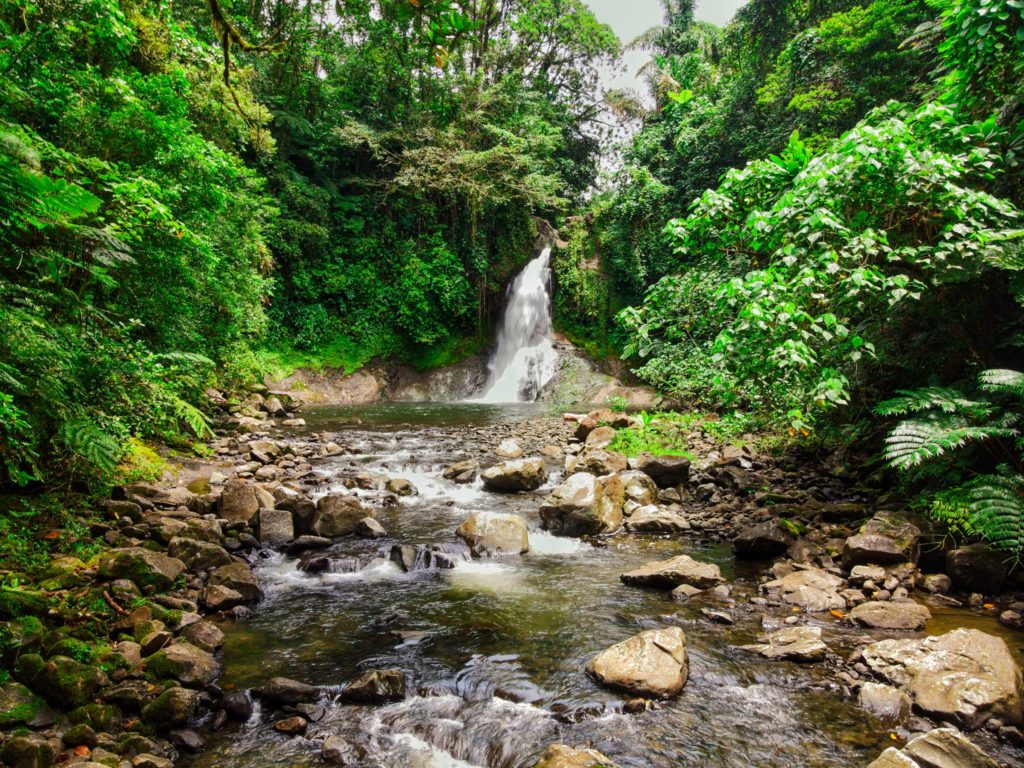
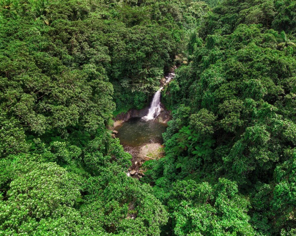
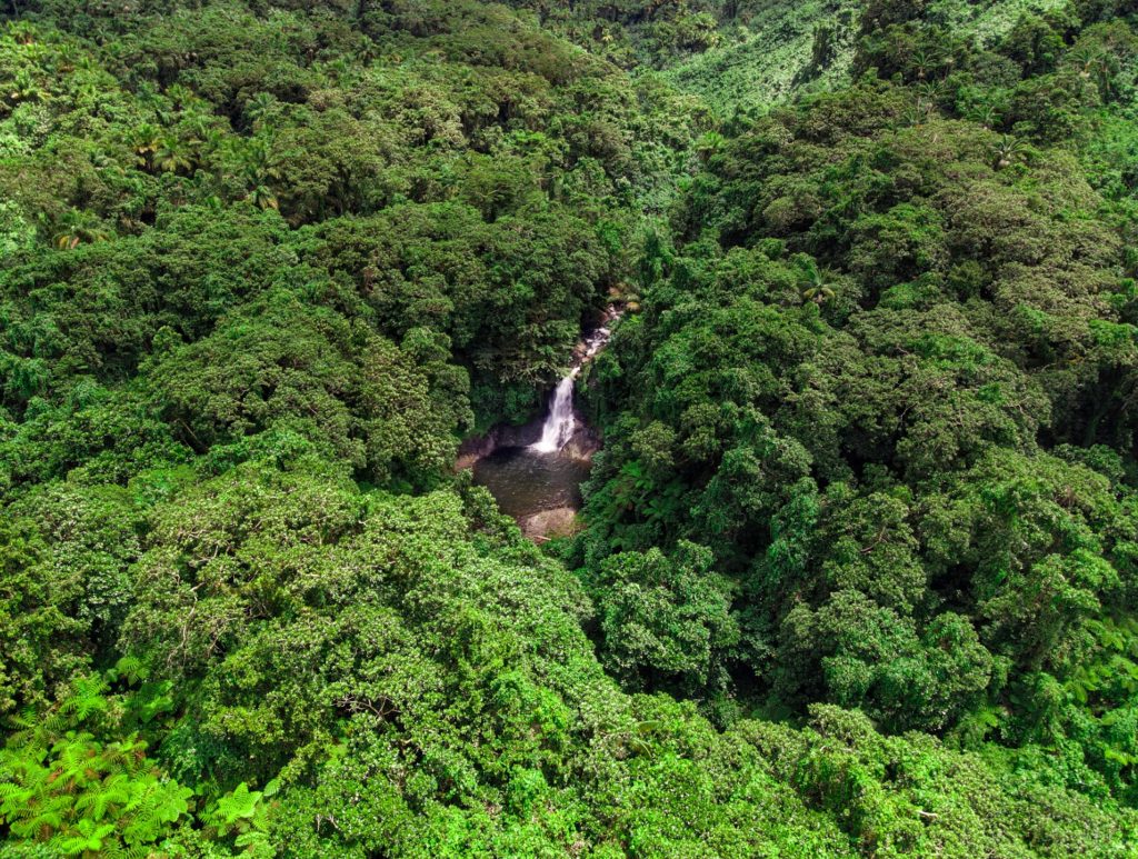
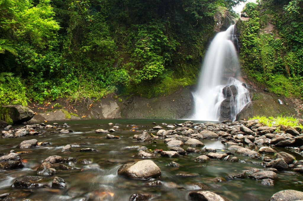
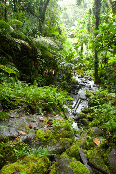
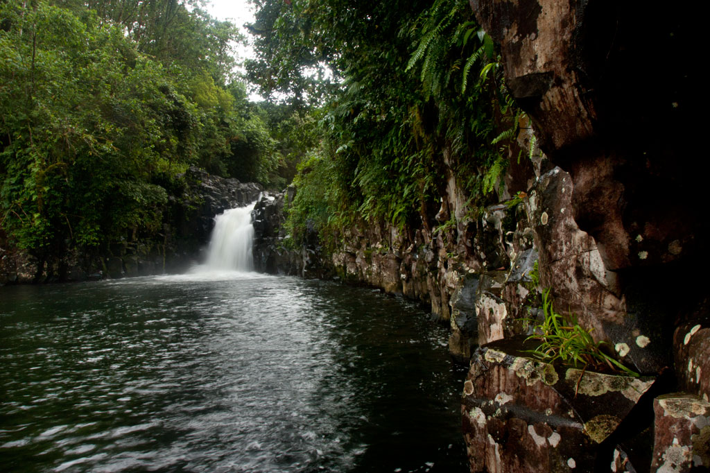
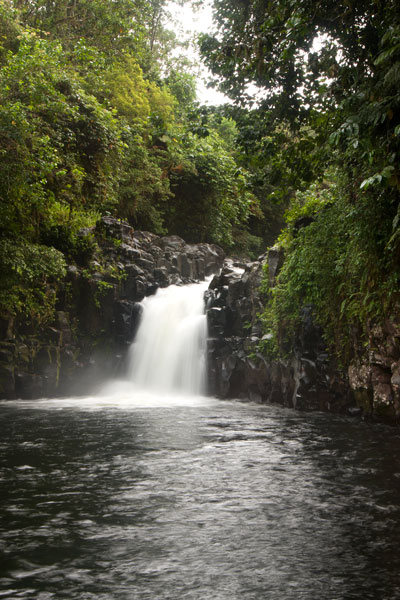
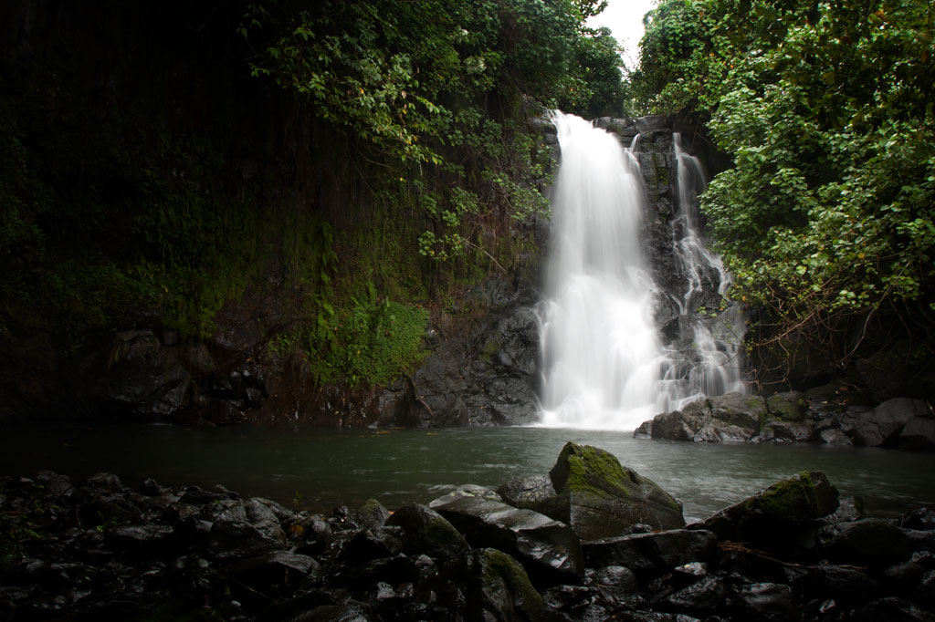
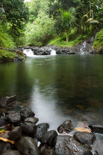
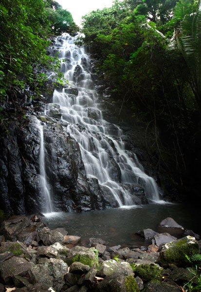
Located on the pristine Senipehn River, Pahn Sile is one of the few waterfalls well into the interior that almost anyone (even small children) can reach without the help of a guide — as long as you keep your eyes open for the branches in the path. A well-maintained trail begins at the end of the unpaved but well-graded coral and gravel road beyond Sapwalap Elementary School and opposite a concrete taxi stop. Houses are found along the path for much of the way, as well as historic rock-lined irrigation canals built by the Japanese. About 0.15 km (164 yd) before reaching the waterfall, a secondary path branches right and descends to a shallow point in the river, where you’ll cross and hug the right bank or walk in the stream as you continue to the falls just around the corner.
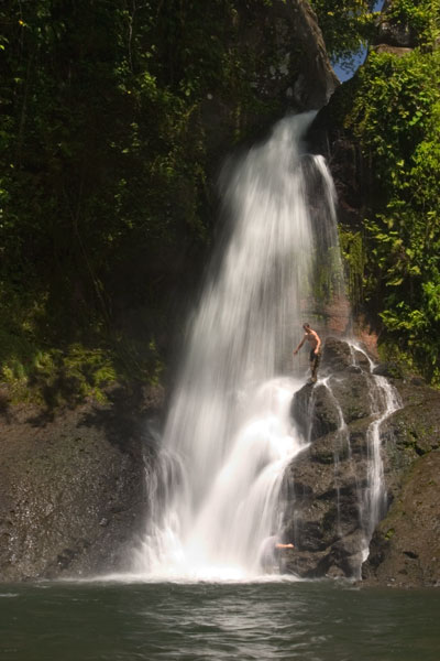
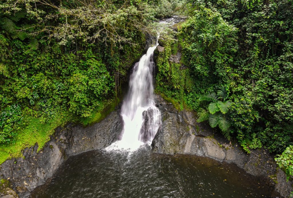
Pahn Sile‘s pool is wide and wonderfully cool, but not especially deep. The falls varies in volume depending on recent rain, gushing through a narrow portal and crashing onto rocks that form the rim of the pool. If you want a view from above the falls, bear left at the branch, proceed for 0.3 km (0.18 mi), and then cut off the trail and head straight toward the sound of the river. There is no path for this last part, but it’s easy enough to move through the forest. There are nice spots for a camp site above the falls in the forest along the path (pack out everything you packed in). In addition to the primary waterfall pool, there’s a small, deep pool just down river that is also an excellent place to swim, shaded by lush ferns and massive trees.
There are no access fees and no permission is needed to visit the falls.
If you would like a guide for the trip to the waterfall contact Raven at (+691)923-1862, he does not charge a fee but we do encourage you to tip him for his time.
- Plan for 3 hours round-trip for this excursion.
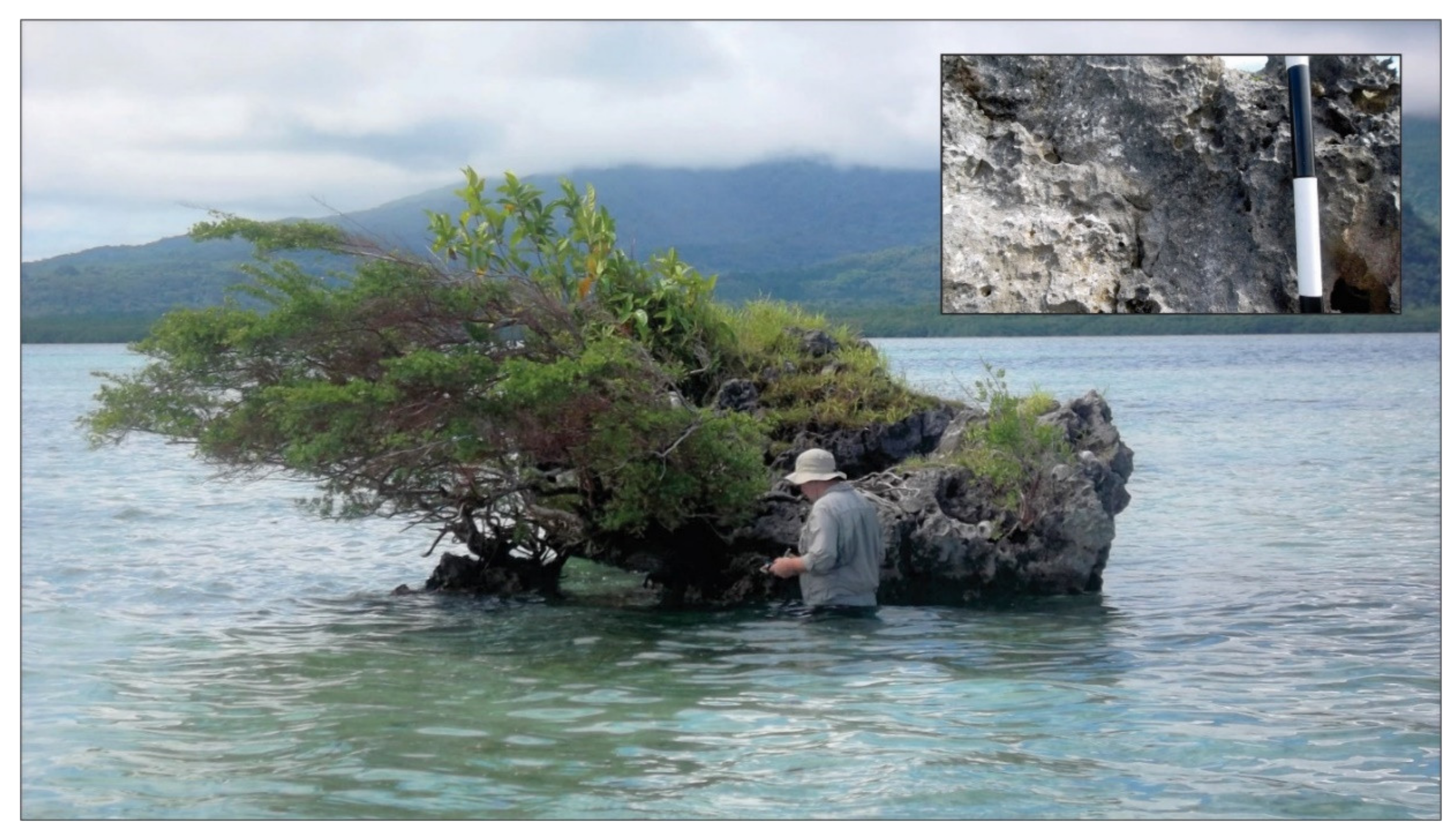
Penieu Island
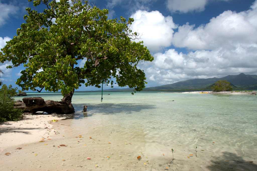
Penieu is a gorgeous reef island in the southeast next to Kepidauen Ne (pass). The island is a major rookery for a colony of noddies and other seabirds, which fill the air with raucous clamor as they swoop around the trees. The primary nesting spot is within a strip of mangroves at the north end of the island (which we’ve dubbed “Noddy City”) and should be given a wide berth to avoid disturbing the habitat of the birds. The island also has a strange, curving sandbar around the north that forms a kind of protected, shallow lagoon with a sandy bottom. This is an excellent place for wading, swimming and playing if you have your kids along, but keep an eye out for stingrays. There are also sandy beaches and good swimming and snorkeling on the west coasts. A pearl farming operation was in progress in the shallow lagoon areas nearby, and a few ramshackle huts were been built on the beach for that purpose (unfortunately, they’re untidy and don’t add much to the scenery). Currents can be quite strong around the eastern side of the island.
- Camping is possible on Penieu, which is owned by the Nahnmwarki of Kitti. Unfortunately, it’s difficult to get him or a family representative on the phone. If you’re interested in visiting, contact the Kitti Municipal Government Office at +691.320.5038, 320.5808, 320.5049, or 320.3257 and ask for assistance.
Nett & Western U GPS Data
Downloadable GPS Data Files
The following files contain all the packaged GPS data for each of the featured locations in Greater Nett & Western U.
Three file types are provided. KMZ and KML files are compatible with Google Earth. KML is compatible with Google Maps. GPX files can be imported into ArcGIS (a professional mapping application) and some hand-held GPS devices.
[info]NOTE: All files are free to the public and can be used for any purpose without permission.[/info]
Marine Parks in Awak Pah (2015)
Dolen Eirike (2015)
Dolen Nahnsapwe (2015)
Lou Rahn Cave & Waterfall (2015)
Nan Kiepw & Na Malek Cave (2015)
Nan Koropwung Cliff, Waterfall & Caverns (2015)
Dolen Nett / Pohnlehr (2015)
Nanipil Vicinity (2015)
These files include Liduduhniap, Sengnaip, Likei, Pahn Pwet, and Nan Kiepw waterfalls, the Nanipil Bird Walk, the Swimming Pond, and another popular swimming hole in the area.
Coordinates
The following coordinates correspond with sites featured on the Greater Nett & Western u Eco-Adventure Map Guide. It is our dream to eventually create a Pohnpei GPS app that could be uploaded to smartphones and other devices, but for now, these points of interest can be entered manually in a hand-held GPS device as needed.
[info]NOTE: All GPS devices have a margin of error. That margin increases with interference — when there is a thick canopy of trees, during bad weather, or when mountains obstruct the satellite link. The geosynchronous satellites employed when navigating on Pohnpei are located low on the southwestern horizon, such that maintaining a strong connection while hiking on the northeast side of a given mountain range can be difficult. Coordinates on the northeastern slopes of mountains are less accurate than in other locations.[/info]
Awak Marine Parks
| Awak Pah MP Entrance | —- | 6.965910° 158.250758° |
| Pein Ahi Entrance | —- | 6.966711° 158.251138° |
| Paieke Entrance | —- | 6.969853° 158.256294° |
| Awak Pah MP Dock | —- | 6.966470° 158.248785° |
| Pein Ahi Fish Pond | —- | 6.967572° 158.249929° |
Dolen Eirike
| Relio Lengsi’s Residence | —- | 6.926688° 158.227910° |
| Dolen Eirike Trailhead | —- | 6.919570° 158.227397° |
| Sakau Plantation | —- | 6.917106° 158.227410° |
| Japanese Trench Network | —- | 6.915589° 158.230300° |
| Dolen Eirike Summit | —- | 6.915140° 158.231599° |
| Dol Rakied Summit | —- | 6.906234° 158.237645° |
Dolen Nahnsapwe
| Dolen Nahnsapwe Trailhead – Nett Approach | —- | 6.927169° 158.246675° |
| Dolen Nahnsapwe Trailhead – U Approach | —- | 6.918897° 158.270844° |
| Dolen Nahnsapwe Summit | —- | 6.909546° 158.260936° |
| Dolen Nahnsapwe Turn-Off from Lou Rahn Trail | —- | 6.923336° 158.249283° |
Lou Rahn
| Lou Rahn Trailhead | —- | 6.927169° 158.246675° |
| Lou Rahn Cave & Waterfall | —- | 6.918551° 158.253955° |
Nan Kiepw & Na Malek
| Nan Kiepw / Na Malek / Nahnalaud Nett Trailhead | —- | 6.918179° 158.214601° |
| Stream Crossing | —- | 6.917458° 158.215238° |
| Nahnalaud Turn-Off from Nan Kiepw Trail | —- | 6.910792° 158.217769° |
| Last House along trail | —- | 6.900363° 158.214973° |
| Na Malek Loop Turn-Off from Nan Kiepw Trail | —- | 6.897523° 158.213266° |
| Na Malek Loop Turn-Off from Nan Kiepw Trail | —- | 6.895756° 158.213144° |
| Na Malek Cave | —- | 6.895878° 158.211765° |
| Kiepw Waterfall | —- | 6.889668° 158.211740° |
| Nan Kiepw Overhang & Campsite | —- | 6.889639° 158.211035° |
Nan Koropwung
| Nan Koropwung Trailhead | —- | 6.925729° 158.254909° |
| Cliff & Waterfall | —- | 6.927155° 158.259679° |
| Cave 1 | —- | 6.927513° 158.259859° |
| Cave 2 | —- | 6.927877° 158.259142° |
| Cave 3 | —- | 6.927884° 158.259038° |
Dolen Nett / Pohnlehr
| Dolen Nett Trailhead 1 | —- | 6.968282° 158.230457° |
| Dolen Nett Trailhead 2 | —- | 6.965640° 158.234757° |
| Dolen Nett Trailhead 3 | —- | 6.959650° 158.225124° |
| Dolen Nett Trailhead 4 | —- | 6.969614° 158.228438° |
| Japanese Tunnel Entrance | —- | 6.965840° 158.228329° |
| Yam Plantation | —- | 6.965248° 158.228609° |
| Japanese Defensive Position | —- | 6.964007° 158.229053° |
| Japanese Trench Network | —- | 6.963868° 158.229051° |
| Japanese Trench Network | —- | 6.963073° 158.229706° |
| Japanese Trench Network | —- | 6.963105° 158.229949° |
| Japanese Trench Network | —- | 6.963125° 158.230125° |
| Japanese Trench Network | —- | 6.963025° 158.230332° |
| Pandanus Grove | —- | 6.961883° 158.230662° |
| Coconut Palm Grove | —- | 6.961188° 158.231013° |
| 80 mm Field Gun | —- | 6.958862° 158.233030° |
| Rusted Barrels | —- | 6.958814° 158.233064° |
| 80 mm Gun in Bunker | —- | 6.958838° 158.233535° |
| Machinegun Bunker | —- | 6.958741° 158.233545° |
| Bunker | —- | 6.958765° 158.233415° |
| Pohnlehr Summit | —- | 6.958226° 158.233346° |
| Japanese Mobile Radar Array | —- | 6.958767° 158.232402° |
Sengnaip Waterfalls
| Trailhead | —- | 6.920677° 158.204421° |
| Route Intersection | —- | 6.920647° 158.201060° |
| Sengnaip Cave | —- | 6.917556° 158.200460° |
| Sengnaip Waterfalls | —- | 6.917522° 158.200383° |
Likei & Pahn Pwet Waterfalls
| Trailhead | —- | 6.920677° 158.204421° |
| Route Intersection | —- | 6.920647° 158.201060° |
| Stream Crossing | —- | 6.919559° 158.198878° |
| Log Crossing | —- | 6.916577° 158.198932° |
| Route Intersection | —- | 6.916577° 158.198932° |
| Route Intersection | —- | 6.914373° 158.199648° |
| Route Intersection | —- | 6.904178° 158.192649° |
| Route Intersection | —- | 6.904178° 158.192649° |
| Likei Waterfall | —- | 6.903375° 158.189810° |
| Pahn Pwet Waterfall | —- | 6.902343° 158.192313° |
Nan Kiepw Waterfall
| Trailhead | —- | 6.919873° 158.206230° |
| Route Intersection | —- | 6.914373° 158.199648° |
| Nan Kiepw Waterfall | —- | 6.897512° 158.206958° |
Liduduhniap Waterfalls
| Trailhead | —- | 6.919915° 158.206706° |
| Upper Pool | —- | 6.918893° 158.206592° |
| Upper Falls | —- | 6.918891° 158.206557° |
| Lower Pool | —- | 6.918564° 158.206676° |
| Lower Falls | —- | 6.918695° 158.206572° |
Nanipil Vicinity
| Nanipil Bird Walk Trailhead | —- | 6.920677° 158.204421° |
| Nanipil Bird Walk Trail End | —- | 6.919559° 158.198878° |
| Hydroelectric Building | —- | 6.918222° 158.214670° |
| Japanese Pump Station | —- | 6.918404° 158.214481° |
| Swimming Pond Trailhead | —- | 6.922461° 158.215089° |
| Swimming Pond | —- | 6.922642° 158.215955° |
| Cable Bridge Swimming Hole | —- | 6.932656° 158.216346° |
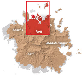
Nahnalaud — the Big Mountain
The Big Mountain
![]()
![]()
![]()
![]()
![]()
The highest mountain in the Federated States of Micronesia (FSM) is called Nahnalaud (which means “big mountain”) and is located almost in the exact middle of Pohnpei Island. Pohnpeians consider the mountain sacred and regard it with respect and reverence, though most people have never been there because of the long, difficult hike involved. Local deer hunters and upland sakau farmers are the most frequent visitors to the highland region. A limited number of foreigners also attempt the summit.
In reality, Nahnalaud is not a single mountain but rather the highest peak in Pohnpei’s contiguous central mountain system, which separates the five chiefdoms. The primary central ridge runs from west to east and then curves north toward U not far beyond Nahnalaud. Additionally, a secondary ridge runs south, leading to Pohnpei’s second highest peak, Ngihneni, and then turning sharply to the west. The two ridges fence in the long, narrow Nanmeir Valley — the most remote region on the island.
The exact elevation at the Nahnalaud summit is a matter of debate as the survey methods used in the 1970s to map the island have a significant margin of error. The official number is 772 meters (2,533 ft), but the peak may actually be higher than that — likely close to 780 m. Ngihneni (“spirit’s tooth”) is nearly the same elevation (a difference of a few meters), which has generated a long-running dispute about which is actually the highest point. Nett, Kitti, and Madolenihmw have also argued about which chiefdom can claim Nahnalaud, but according to the municipal boundary lines on the 1983 USGS map, each of these municipalities has a piece of the peak.
Hikers should be careful not to underestimate the mountain. Though the distance is not extreme, the terrain is. Experienced trekkers will find all of the approaches challenging merely because of the very rugged nature of Pohnpei’s interior mountains. The concept of switchbacks is little known on Pohnpei; trails are rough, rocky, and often go straight up the slope. Hikers who plan to tackle Nahnalaud should be prepared to walk along narrow ridges with steep slopes on either side; cross jumbles of broken, slippery rocks; ford medium-sized rivers (particularly on the Nett and Madolenihmw routes); walk in shallow, rocky riverbeds; ascend and descend slopes of 50 degrees or steeper; wade through muddy mires; cross slick logs; and push through high grass or ferns.
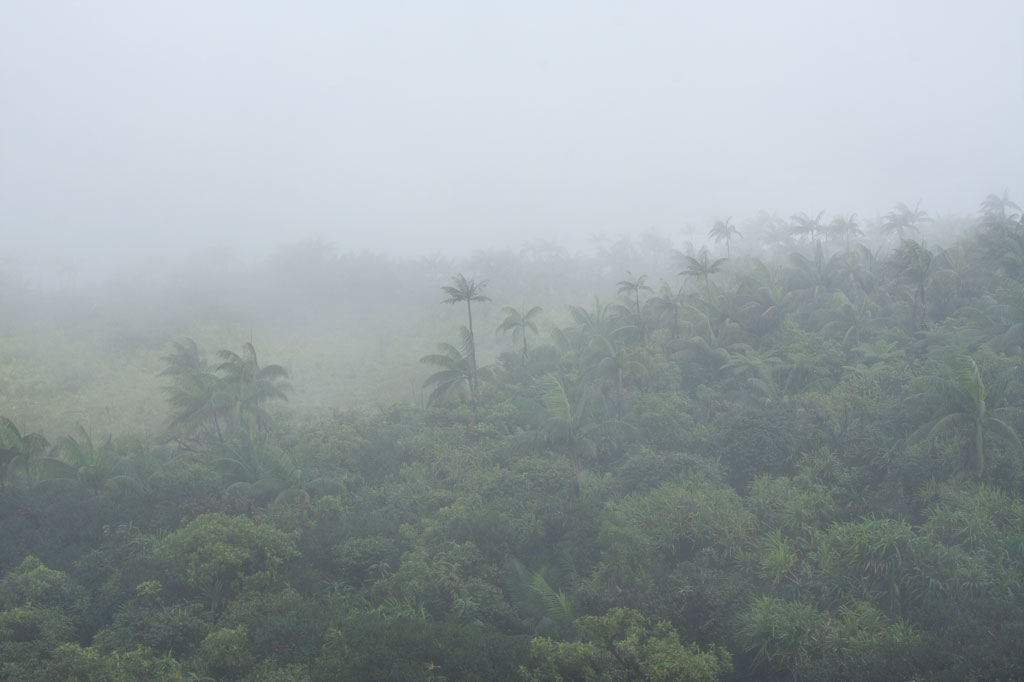
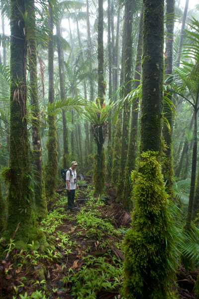
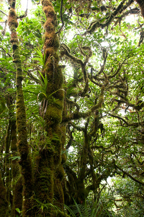
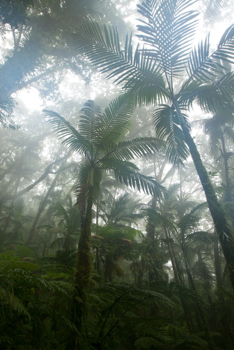
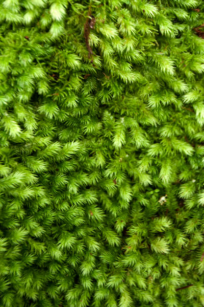
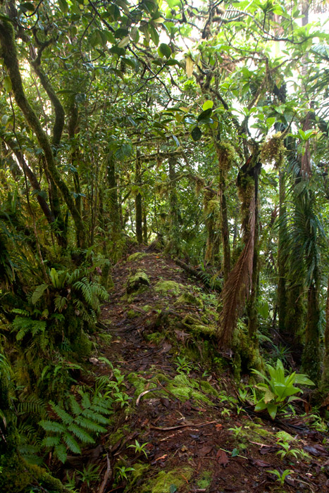
Despite the difficulty in getting to the top, the trip is well worth it. Those who have never visited a cloud forest before will be awed by the otherworldly beauty of the ridge, a perpetually dripping wonderland of stunted, hoary trees, air plants, and bryophytic growth. Virtually every surface is covered with a thick layer of spongy golden moss and the ground is composed of layer upon layer of damp, decayed matter. The area, which never dries out, gets at least 8.3 meters (325 in) of rain every year and is shrouded in thick fog much of the time, making clear views from the summit a rare occurrence.
[tabs]
[tab title=”Pehleng”]
Pehleng Approach (Western Kitti)
This well-defined trail up to the primary ridge and eventually to Nahnalaud was first promoted in 2013 by a local business calling itself Pohnpei Trailways. The idea was that this trail, starting in Pehleng, could be hiked by tourists without the assistance of a local guide. We strongly recommend that you do NOT do it that way. In fact, we think it’s a very a bad idea. Though at the time of writing (2014) the entire length of the trail was marked with pink flagging tied to tree branches, there is still plenty of potential for visitors to go astray. Furthermore, accidents or injuries without a local guide present could result in disaster. Remember that Pohnpei has no search and rescue service.
The true ascent begins after passing through a cluster of houses (ask permission) 0.95 km beyond the trailhead. After that, the trail is wide and true as it climbs steadily for 1.45 km (20% slope average) through the forest to the open fern meadow atop Dolen Salapwuk (510 m), where there are some good views in clear weather. The trail then re-enters the forest and begins to climb again for 4.6 km (13% slope average), narrowing as it comes up to the main ridge (696 m). Just before Shelter 1 (Dolmweir), there’s a 315 meter-long segment that is less than a meter wide with precipitous slopes on both sides; we’ve dubbed it the “Knife Edge.”
Shelter 1 is located at Dolmweir, where an appendage of the mountain thrusts north from the main ridge. There is no flowing water nearby. The privy is located 22 m to the north. After Shelter 1, the trail descends steeply by about 62 m on the south side of the ridge and skirts the base of a rocky cliff before climbing back to the ridge-top. From there it goes up and down for 2.94 km before reaching Mountain Shelter 2 roughly 5 minutes below the Nahnalaud summit.
- Plan for 5-7 hours from the trailhead to Shelter 1 and 3-4 hours from there to the summit.
[warning]NOTE: As of February 2014, the pandanus-thatch roofs of the two ridge shelters were in very bad shape, heavily deteriorated and leaky. Plan accordingly.[/warning]
The Origin of the Yap Banana
In the westward land of Sapani, a woman named Lienpwel (“woman of earth”) had two daughters, Lisoumokaiap and Lisoumokalang. The daughters decided to take a canoe and look for new land in the east and brought with them some “underworld yams”, banana shoots, and a stone called the Stone of Sahwar. The sisters eventually landed at a place in what is now Pwoaipwoai district (at that time the island was smaller and Pwoaipwoai lay near the coast). There they placed the stone and planted the yams. The stone was highly reflective, and when the sun would hit it, it would shine brightly (hence the name Sahwar, which means “shining” or “flashing”).
The younger of the two sisters, Lisoumokalang, eventually returned home to Sapani. On the way she visited the islands of Yap and propagated a new type of banana, which thrived and became the tallest of all banana varieties. Some time later, a Pohnpeian man who lived in a place called Loangen Kitti was looking west toward the sunset and he saw the tall banana plant in the distance. The ripe fruit were attracting many birds, so he found two starlings – one a common Micronesian starling (sioahk) and the other a Pohnpei mountain starling (sie) – and he took them up to a high mountain in Pehleng. The Micronesian starling was a lazy flier, but the mountain starling was clever and efficient. He sent both flying toward Yap. The Micronesian starling was distracted on the way and diverted from its course. Only the Pohnpei mountain starling reached its destination. It joined the other birds in eating the bananas, and while it did so, a seed became lodged in its feathers. Both birds eventually flew back to Pohnpei and landed at the peak of Pekenuht (which, appropriately, means “banana feces”). The seed carried by the mountain starling fell to the ground and propagated utin iap (the Yap banana).
[/tab]
[tab title=”Enipein Powe”]
Enipein Powe Approach (Kitti)
This route begins at the end of an unpaved road in Enipein Powe and climbs gradually on a well-defined footpath up an out-thrust from the southern ridge. At the top, the trail passes through a saddle between Nahnan Pwoaipwoai and Dolen Uhd, then descends slightly along the inside of the ridge slope, finally arriving at a massive overhanging rock known by local guides as “the cave.” The cave has nice views through the trees of the Nanmeir Valley at the Lehnmesi River source below. You can also see Nahnalaud to the northwest and make a guess at the direction of Ngihneni to the east. The cave is an excellent place to camp with a cushioned fern-lined floor (that stays dry in wet weather) and usually some dry firewood stowed by hunters in the vicinity (replace what you use).
From the cave, the trail continues along the inner slope below Ngihneni, crosses several small streams, and then climbs steeply (20% slope average) to the top of the main ridge. At this point it’s just a short walk west along the ridge path to the first open viewpoint near a USGS benchmark. The spot people typically consider to be the summit is 5-10 minutes further, and Shelter 2 is just below that.
- Plan for 6-8 hours from the trailhead to the cave and 90 minutes to 3 hours from there to the summit.
[/tab]
[tab title=”Salapwuk”]
Salapwuk Approach (Kitti)
There are many ways to Nahnalaud from Salapwuk but they all begin at the end of the road beyond Salapwuk Elementary School. The early part of the hike uses the same trail as the Six Waterfalls, but at the place where one would turn toward the river to encounter Falls #1 (Pahnairlap), one instead follows a trail going northeast. This trail stays north of the river, crossing above Iro, Nan Emp, and Lipwentiak waterfalls. The latter is the most spectacular, located where the river gets funneled into a narrow channel and makes a hairpin turn. According to legend, this feature of the river was created when the matriarch of the Great Eel Clan encountered an eel hunter and writhed violently in horror at the sight of the dead eels he was carrying. Small pools above the falls are home to Pohnpei’s endemic freshwater shrimp, which the guides might be willing to catch for dinner. After that, the trail only meets the river again twice, where it cuts through a wide loop in the watercourse. It then turns north and climbs 362 meters in elevation to the primary ridge, not far from the summit.
[/tab]
[tab title=”Nanipil”]
Nanipil Approach (Nett)
Though slightly shorter, the Nanipil approach to Nahnalaud is certainly challenging. It’s significantly steeper than the other routes (except Salapwuk) and the trail is not well-maintained once you reach the rear of the valley. The hike starts at the house next to the hydroelectric building at the end of Nanipil River Road. Immediately behind the house, hikers must cross a river and then shortly after that a small stream. An easy segment follows with a well-defined residential path leading to the last house in this part of the valley (1.39 km), where an old man lives alone.
Past the house, the route continues on a fairly well-defined path that crosses the river several times (these crossings can be tricky if there has been a lot of recent rain). In a few places, you have to walk in the river itself, which can be quite difficult given the slickness of the rocks. Finally, after 2.94 km (3% slope average), the trail begins to climb out of the valley on the east side of the river and follows a sub-ridge up from there (3.16 km with a 22% slope average).
The climb has several pitches with small, flat rest areas in between. The first stop has a conspicuous tree of gigantic proportions entwined with vines almost as massive. The second stop is frequently used as a camp site by hunters and is one of the few places on the mountain with mobile phone reception. The final segment leading to the primary ridge is steep and often muddy. In places it follows the natural pathway of small streamlets (keep an eye out for a small waterfall high up on the slope). Once reaching the main ridge (754 m elevation), it’s an easy 0.56 km walk east to Shelter 2, a typical nahs-style thatched hut that can sleep ten or so.
[warning]NOTE: As of February 2014, a large part of the roof of this shelter had rotted away, leaving the central part of the hut exposed to the elements.[/warning]
[/tab]
[tab title=”Nankepinmerepw”]
Nankepinmerepw Approach (Madolenihmw)
This route passes through the gorgeous valley of Nankepinmerepw, following the upper tributaries of the Nan Riohk Stream and eventually arriving north of Nahnalaud on an arm of the primary mountain system.
The hike begins at a rutted turn-off from the well-graded (but unpaved) road to Pahn Sile Waterfall, leads to a metal footbridge over the Senipehn River — the only bridge like it on the island — and connects with a path on the far side. From there, the trail meanders northwest not far from the Nan Riohk and more or less parallel to it.
The first kilometer or so cuts through cultivated lands. Then it begins to follow the water more closely as it passes into the wilder riverine forests. There are at least nine major stream crossings in this next segment, some of which may be difficult or impossible if there has been a lot of recent rain. Above the last major Nan Riohk tributary, where the name of the stream changes to Nankepinmerepw, hikers take to the stream bed itself, which is certainly the most challenging aspect of the route (13% slope average). The algae-slimed rocks are slick and dangerous and hikers may find that they have to go very slow and use both hands to avoid disastrous slips; it would be easy to snap an ankle or shatter a kneecap in this place. Despite the rough terrain, the scenery in this narrow valley, often fenced on both sides by high rocky walls, is terrific. At times, the trail passes along the tops of vertical prismatic basalt columns.
The first few points of interest are beautiful pools that will tempt any overheated hiker — and why resist? A bit further is a small waterfall near a prismatic basalt quarry site for Nan Madol. Abandoned prisms can be found lying in the stream bed in several places — the largest just below the falls. How exactly prisms were hauled down to the coast from this site is anyone’s guess. After a short, steep section (22% slope average), the valley terminates at a huge “horsetail” waterfall that the route crosses above (you can scramble down the eastern slope without too much difficulty for a better view from the side). The shallow pools above the falls are also an excellent place for a look at Pohnpei’s native crayfish.
Past the big waterfall, the stream narrows until it reaches a third waterfall — this one short and wide, falling over a straight lip (usually called a “block falls” or “sheet falls”) — and then diminishes to a trickle. From this point, the hike climbs west (29% slope average) and then south again as it follows the ridgeline (18% slope average) toward the Nahnalaud summit.
[/tab]
[/tabs]
How Long Will It Take?
Though it is possible to hike up and down Nahnalaud in one day, as we did during one of the many data-gathering excursions, we don’t recommend that you put yourself through that kind of torture. Hiking to Nahnalaud should be considered a 2-day affair with one night spent either at the cave, one of the mountain shelters, or somewhere else on the ridge. Inexperienced or out-of-shape hikers may need three days or more.
Hiring a Local Guide
All of the routes up to Nahnalaud require an experienced local guide.
You should offer your guide no less than $160 if there are five or less in your group and at least $220 if there are more than five (plus tips). If you do the math, you’ll see that this is quite reasonable. With five people, each hiker pays just $32 plus tips — a super bargain. If you can’t assemble a group, you’ll still only pay $80 per person with two hikers, which is less than you’d pay for two dives at virtually any SCUBA company in the world (and this is two days and one night). Obviously, if you plan to take a slower pace and do the hike over three or more days, you’ll need to pay your guide more.
Your guide is your lifeline; you will depend on him to keep you safe and on the right track throughout the duration of your hike. Guides provide other useful services as well, such as making campfires in damp weather. If you expect your guide to cook meals for the group or carry any gear for you, he should be paid extra. Agree on a price beforehand.
- Please visit the Local Guides & Tour Operators page for a list of experienced guides available for hikes to Nahnalaud.
Sapwtakai and Other Prehistoric Cultural Sites & Ruins
Prehistoric Sites & Ruins in Kitti
[tabs]
[tab title=”Sapwtakai”]
The Fortress of Sapwtakai
Sapwtakai (“rock land”) is a 13,000 m2 stone complex that crowns a hill north of Wenik. The site was first occupied around 1250 A.D. and functioned as a political center for at least four centuries. The walls, terrace platforms, stone-paved walkways, tombs, and other features were built in three phases. The upper portion of the fortress was the residential area, while the southern part was the ceremonial center.
The wall on the north side of Sapwtakai is higher than at other points — presumably to deter enemies from that direction, while the steep slope on the east side offers natural protection. About 15 meters north of the complex perimeter is another free-standing 1.5 to 2 meter high wall that runs south and east. These defensive structures failed, however, to protect the fortress from incursions by the Dipwinpehpe clan, which took control of Pehleng and then moved south, driving out the Soukitti clan and conquering Sapwtakai. The fortress was occupied for a period of time, during which the Dipwinpehpe destroyed some of its features. Neighboring Onohnleng eventually decided that the need to regain power over the region justified open war. The main force of warriors were sent marching north from Lukoap. At the same time, a fleet of canoes was assembled off the coast. But instead of containing more fighting men, the canoes carried dummies. The Dipwinpehpe saw what Onohnleng wanted them to — two separate forces set against them. They divided their own army to deal with both the men on land and the fleet, only to find that they’d been tricked. The divided army was soon defeated by the men of Onohnleng, Sapwtakai was retaken, and the regions that now make up Kitti were united under centralized leadership for the first time.
Sapwtakai continued to be utilized for some time after the unification of Kitti, but was abandoned around 1850. Other than a meticulous archaeological survey by Joyce Bath in 1980, the ruin has mostly been left to time and nature — rarely visited and entirely unmanaged by Pohnpei State and the Historic Preservation Office. A lot of the hill has been overgrown by wild hibiscus, durien, and hellishly stickery wild yam vines with spines that will go right through the soles of booties or FiveFingers. There is still much to see, but it’s imperative that one finds a good guide who knows the site well.
Points of interest include boulder walls as tall as 2 meters beyond the northern perimeter, a platform of tabular basalt in the northern corner that rises 2 meters above the wall, several 450-year-old house platforms with central fire pits, breadfruit storage pits, a large burial complex constructed of basalt boulders and prisms and containing two openings leading to a central crypt, a contemporary Japanese slit trench, a 2-tiered platform with a central fire pit where hammer stones for pounding sakau were discovered, and seven river cobbles that are said to be magical sling stones.
[/tab]
[tab title=”Kitti Rock Area Sites”]
“Kitti Rock” Area Ruins
The cluster of ruins on the slope below Sapwtakai were referred to as “Kitti Rock” by archaeologists because a basalt stone from Nan Madol was placed in the area when Kitti was founded. There are many sites. We’ve highlighted only a few here.
Dolomar Paiei (Site 35-26)
This is a two-tiered stone platform in Sapwtakai district with terraces on two sides.
Dolomar Pailong (Site 35-14)
This is a stone platform southwest of the Sapwtakai ruins.
Peidolenmai (Site 32-8)
Peidolenmai (“stone platform of the hill of breadfruit”) is a 3 x 4.5 meter stone platform in Alauso with two breadfruit storage pits inside the enclosure. The pits and the name indicate the purpose of the site.
Peinkareraua (Site 35-17)
Peinkareraua is a stone platform with an enclosing wall 2 meters thick and two low platforms that together formed the residence of the ruler of Kepihleng and the center of state ceremonial events, located southwest of Sapwtakai ruins in Sapwtakai district.
There are many access points for these ruins. It’s possible to cut southwest from Sapwtakai and find oneself in the midst of the highest concentration of the “Kitti Rock” sites, but trails also run from Nanmand, Marahu, and Seinwar. Ask around for guides at houses in those areas.
[/tab]
[tab title=”Diadi & Wenik Sites”]
Diadi & Wenik Sites
“Dolen Samaki” (Site 30-18)
This is a stone enclosure on an 86 meter hill in Wenik district, identified by the name of the hill on which it is found. At the site is a huge magical boulder (takai wek mai) that was used in combination with a spell to ensure a good breadfruit harvest. There are also three other large boulders with special properties. The site is mentioned in the oral history of Utin Iap, the “banana of Yap”.
Pahn Kipar (Site 30-19)
Pahn Kipar is a 5 x 6 meter stone terrace platform with an extended breadfruit storage pit in Wenik district.
Peinmwas (Site 30-20)
Peinmwas (“stone platform of the worm”) is a stone platform, now mostly buried or scattered, between Wenik and Diadi districts. The site is mentioned in the Utin Iap (“banana of Yap”) oral history.
Pohn Kohla (Site 27-3)
This 13 x 15 meter rock platform and stone-paved terrace is located between Wenik and Diadi districts on the southern slope of a hill. The location has two peitehl (sakau stones) and an uhmw (rock oven) site.
The most direct access point for these sites is at Oare, but it’s also possible to reach them via trails beginning opposite the Kitti SDA Church. Ask around for guides at houses and stores in either of these locations.
[/tab]
[tab title=”Seinwar Sites”]
Seinwar Area Sites
Niahlek (Site 34-29)
This is a single 5 x 6 meter stone platform with a central pit located in Seinwar district.
Soaid (Site 34-32)
This stone burial platform is found in Seinwar district on the hillside above the Circle Island Road.
It’s possible to find people in Seinwar who can lead visitors southeast past Soaid, Niahlek, and other sites in this vicinity. Ask around at houses and stores along the main road.
[/tab]
[tab title=”Pan Pei, Alauso, Poatoapoat & Wenik Sites”]
Pan Pei, Alauso, Poatoapoat & Wenik Area Sites
Narong (Site 31-17)
This is a semi-circular stone terrace platform with a large shell midden, where a number of artifacts — including a breadfruit pounding stone, hammer stone, and coral grinding stone used to make breadfruit peelers from cowrie shells — were found. Breadfruit was prepared at this place for preservation in pits. The site is located in Poatopoat district.
Pan Pei
About 680 meters southwest of Sapwtakai and 400 meters northeast of the Kitti Municipal Office are the structures of Pan Pei. The primary feature in the group is a 169 m2 burial platform built of prismatic basalt columns and containing four crypts. The platform is about 1 meter high. At one point in the past the crypts were roofed with columns. A road 25 meters south of the Municipal Office leads up into the hills, passing several of the Poatoapoat sites and connecting with a footpath that runs north to the Pan Pei sites before ending at a residence. From the residence, another footpath goes southeast to the top of a hill where the Japanese had an anti-aircraft gun installed (the gun is not there now).
“Pilen Koaroan” (Site 35-19)
“Pilen Koaroan” consists of three stone structures, including a double vault tomb attached to a wall and a stepped platform with a central pit. It’s part of the “Pan Pei” group.
“Diadi” (Site 30-16)
This is a single 9 x 11 meter stone platform surrounded by a wall and identified by the name of the district in which it lies. The area is marshy. The wall ranges from a half meter to a meter in height and has a single entrance about a meter wide, while the central pit is little less than a square meter and a third of a meter deep. “Diadi” is also unique because the walls consist of boulders, flat stones, and oblong basalt prisms mixed together.
Site 30-17
This is a stone ruin in Diadi district just below the peak of a hill and nearby the “Diadi” ruin.
For these sites, ask at and around the Kitti Municipal Office for a guide.
[/tab]
[tab title=”Salapwuk Sites”]
Salapwuk Area Sites
Elen Eni
Elen Eni (“ghost path”) is the sacred burial site of a number of traditional high priests, called soumw. These priests were instrumental in the religious cult that thrived in Salapwuk prior to the conquest of Christian missionaries. Many Pohnpeians are afraid of the site and would never go there or consider taking a foreigner there, but there are some guides who would be willing to make a visit if certain ground-rules are followed.
Lehn Mwahmw
Lehn Mwahmw (“fish pool”) is a natural pool on the Lehnmesi River rather than a man-made site. Located in Salapwuk district, the pool is believed to be a spot that Pohnpei’s early settlers stocked with fish upon arrival.
Lehnpoudek
Lehnpoudek (“mooring pool”) is another natural pool on the Lehnmesi. Myth suggests that Pohnpei’s founder, Sapwkini, and his entourage moored their canoes at this spot.
“Rasalap” (Site 24-7)
This is a 10 x 14 meter stone complex (141 m2), consisting of boulders stacked to form two low platforms separated by a wall and enclosed in a meter high perimeter wall. Once again, the name actually refers to the area — a huge, marshy savannah and fern meadow on a hill west of Salapwuk district — rather than to the structure itself. The most unusual aspect of the site is the dual courtyards — a feature atypical in prehistoric Pohnpeian architecture. The site’s purpose is not clear.
Sokosoken Leng
In the forest off the west side of the road past Salapwuk Elementary School is a basalt boulder with a coralhead on top. Sokosoken Leng (“landing of heaven”) and its stone marks the spot where Pohnpei’s mythical founder, Sapwkini, first docked his voyaging canoe and later began to build Pohnpei on the reef, using magic to pile up rocks and earth to form an island.
Takain Pwohng
Takain Pwohng (“stone of night”) is a trio of boulders along the Lehnmesi River, where one high priest (soumw) of the Salapwuk religious cult was said to have lived in ancient times, allegedly performing human sacrifices and ritual cannibalism at a small cave under the largest rock.
The best point of contact for the Salapwuk sites is Welten Panuel. If Welten cannot take you himself, he will be able to recommend a guide for most or all of the Salapwuk area sites. Visit the Guides & Tour Operators page for contact info.
[/tab]
[/tabs]
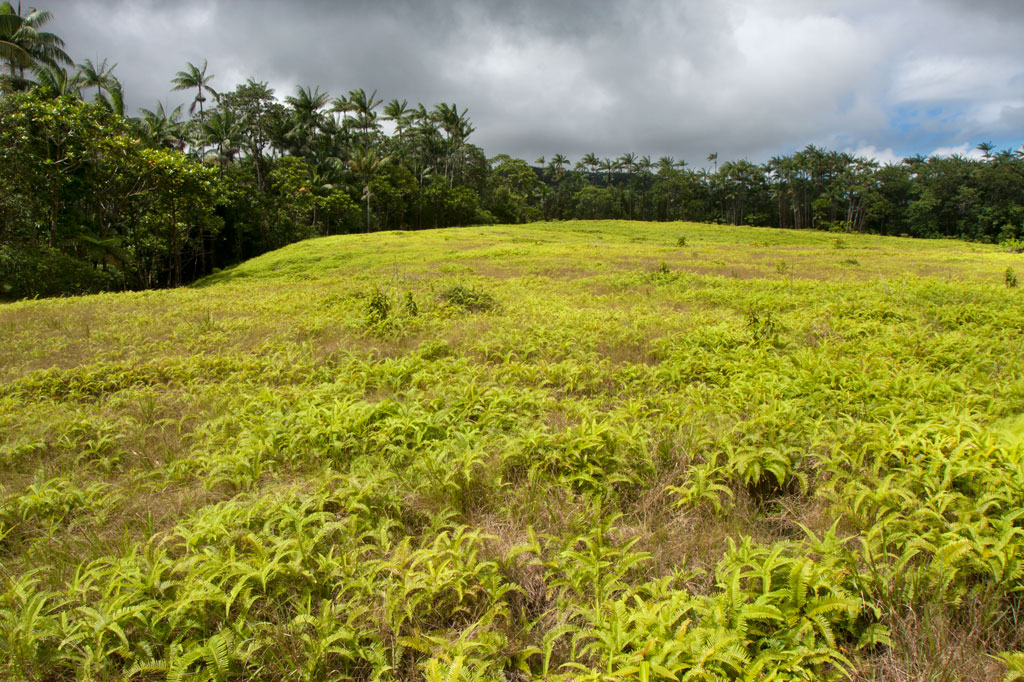
Pohn Pehnmen Savannah
Mallen Pohn Pehnmen
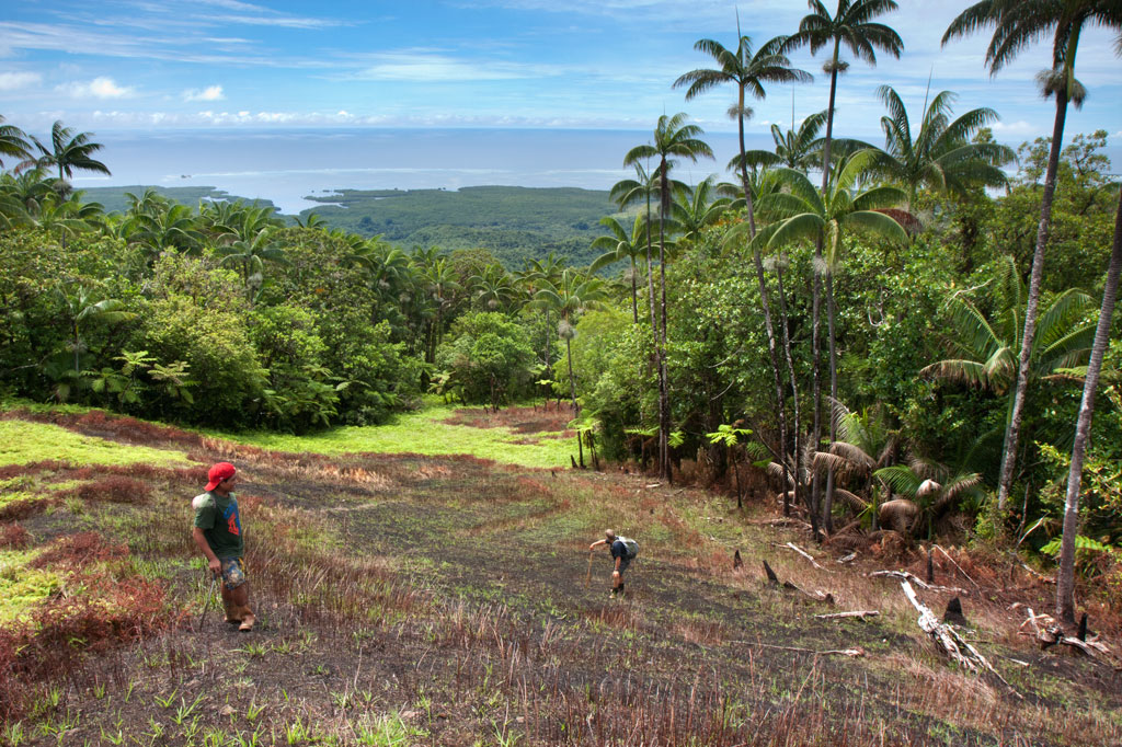
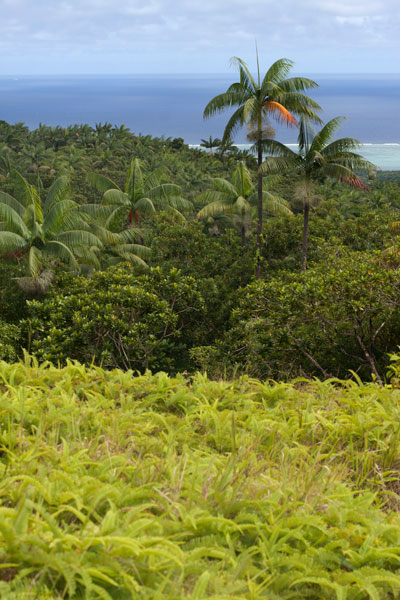
In the remote mountainous area called Pohn Pehnmen is an upland savannah similar to those on the Nihpit plateau, but smaller and at a much higher elevation. The meadow, reached by deviating west from the Enipein Powe trail to Nahnalaud, has a strong slope to it with a central hill and an open view of the ocean and lowlands. Most of the area is covered by low, spreading ferns and club moss, while giant tree ferns and endemic kotop palms (Clinostigma ponapensis) are clustered along the fringe.
Like Nihpit, the moderately difficult, but rarely steep, trail is dominated by groves of Atuna racemosa, which Pohnpeians call ais. This tree’s unusually hard wood, termite-resistant quality, and straightness makes it a popular choice for construction projects on the island. The fruit are also used medicinally and to create the red paint commonly used on Pohnpei canoe hulls. You’ll see bio-luminescent salengen eni (“ghost’s ear”) mushrooms, many types of bracket fungi, including one that has sadly been the target of poaching by visitors from at least one Asian nation, and a startling diversity of bryophitic growths on trees and logs. There are a number of small stream crossings. Birders will find a lot to look at both in the forests on the way up and around the meadow.
The hike begins at the end of the road near the FSM Telecom mobile phone tower, cuts through a grassy clearing, and enters the first. The 0.26 km (0.16 mi) to the first branch in the path is mostly flat; bear right. After that it climbs pretty steadily for 1.4 km (0.87 mi) at about a 17-18% slope. There’s another branch about 0.52 km (0.32 mi) from the top; again, bear right.
- Plan for 5-8 hours for this hike.
- Please visit the Local Guides & Tour Operators page for a list of experienced guides available for hikes to Mallen Pohn Pehnmen. Offer $25-50.00 for a group of five or less.
Lehnpaipohn Waterfall
Kitti has a lot of waterfalls, but one of the most fun to visit is Lehnpaipohn between Salapwuk and Pwoaipwoai districts (at least two kousapw claim the falls area). It is neither the tallest waterfall on Pohnpei nor the most picturesque, but what Lehnpaipohn does have is the largest freshwater pool on the island (about 80 by 30 meters) and the highest jumping-off spot. The pool is leaf-shaped, very deep, and surrounded by high cliffs with a sizable island of river cobbles in the center. The water is typically quite chilly, which is a good thing after the hike. The waterfall itself is not much more than 4 meters (13 ft) tall and has a platform of rock behind it that you can stand on. Swimming to it is difficult, however, because of the strong current coming away from the falls. The best tactic is to swim along the edge and use the rocks to pull yourself forward.
The trail is only 0.53 km (0.33 mi) from the unpaved secondary road, but that road’s conditions are so bad that you’ll want to park your vehicle way down at the end of the paving 0.4 km (0.25 mi) above the Circle Island Road and walk up (5-15% slope with an average of about 7%). Look for the unmarked footpath on the left 2.18 km (1.4 mi) beyond the paving and 117 meters (128 yd) past the last visible residence on the right. The path is well-defined, relatively easy to follow, and downhill almost the whole way to the river (12% slope average). It stays under the trees and is rocky except at one point, where there’s a swampy section to cross or navigate around. About 216 meters (236 yd) along, the path branches; stay to the left. Another 200 m (219 yd) brings hikers to a small stream crossing. From this point, there’s only another 89 m (97 yd) to go. The final descent to the pool is exposed and a bit sketchy (especially when descending); make sure you have good footwear (FiveFingers are best, but good tennis shoes will work, too) and take special care on wet days.
No fees are charged and the trail is on public land. You can do this hike without a guide.
Camping
You can camp under the trees at the top of the eastern cliff — also the spot from which swimmers leap. Pack out everything you brought in and leave the site as you found it.
- Plan for 3-4 hours for this hike including some quality time to swim and relax.
Nihpit Plateau Savannahs
Mallen Nihpit & Mallen Pitetik
On the large upland plateau of Nihpit in the mountains above Mwoakot are two expansive savannahs or fern meadows. Upland savannahs of this sort usually exist because the bedrock is shallow, but they are also periodically burned by residents, inhibiting the growth of larger shrubs and trees. Hunters say that the Philippine sambar deer that live in Pohnpei’s interior — probably introduced by the Germans from the Mariana Islands — are attracted to the ash. One hunting tactic is to lie hidden at such sites and wait for the deer to creep from the forest in the early dawn (photographers might use the same method). Both of the savannahs soak up rain and feed tributaries of the Ne Stream (Pilen Ne). The northernmost and the larger of the two meadows — about a half kilometer in length — is usually referred to as Mallen Nihpit. The other savannah is Mallen Pitetik. Birders and photographers will find this a wonderful place to camp and observe fauna rarely disturbed by human activity. The palm forests around the edge provide plenty of shade, and drinking water can be filtered at the stream about 100 meters away.
The hike begins on the right side of the unpaved secondary road opposite the track leading to the Wene Latter-Day Saints Church — 0.92 km (0.57 mi) past the Nanwou Stream bridge — and leads up to a farmstead. Your guide will stop at a cluster of residential buildings to ask permission to cross the family’s land before leading you on. About 160 m beyond this is the first of two major stream crossings — one on a log and the other across a covered wooden bridge. After the second bridge, the trail climbs steadily for 1.47 km (0.9 mi) at a 25% slope average into forests full of huge Terminalia carolinensis (kehma) — found only on Pohnpei and Kosrae — and Atuna racemosa, a tall, straight hardwood locally called ais. The latter have many uses including treatment of diarrhea and dysentery. The white nut inside the ais fruit is ground and mixed with red soil to produce paint for canoes, while the extremely hard and termite-resistant lumber is a favored building material. If you hike in the evening, keep an eye out for eerie salengen eni (Filoboletus manipularis), bioluminescent mushrooms said to grow in areas where ghosts reside (the name means “ghost’s ear”). The tiny fungus often grows from rotten logs and looks like clusters of eyes in the dark. Interestingly, some Pohnpeian parents are known to control misbehaving youngers by threatening to send them to places where the mushrooms thrive. At this point, hikers have reached the edge of the plateau and the remaining 1.08 km (0.67 mi) is relatively flat with a 6% slope average. There are four small stream crossings along the hike. The first three come down from Mallen Pitetik and converge, forming a high waterfall as they drop off the plateau; follow the second stream up for 0.34 km (0.2 mi) to reach that savannah. The last stream originates in Mallen Nihpit and makes a good place to filter/purify water when camping in the area.
- Plan for 8 hours for this hike.
- Please visit the Local Guides & Tour Operators page for a list of experienced guides available for hikes to Nihpit. Offer $50.00 for a group of five or less.
Mand Area Attractions
![]()
![]()
![]()
![]()
![]()
Mand is a little community of Pingelapese people who were given a parcel of land by the Nahnmwarki of Madolenihmw in Pohnpei’s modern past. You can’t call it a town, but it feels more connected than many of the island’s Pohnpeian communities. In addition to the Pingelapese who live in Mand Proper, there’s a small village to the north inhabited by Kapingamarangi islanders, who settled in the area very recently (Kapingamarangi is a distant atoll that is culturally and linguistically Polynesian but politically a part of Pohnpei State). The center of Mand consists of the elementary school and church. Next to the church is a monument which lists the names of the first settlers from Pingelap Atoll — the founding members of the community.
Kokomaru Waterfall
Most local people outside of Mand have never heard of Kokomaru, which is strange, because it is a gorgeous spot and worth visiting. The route to the waterfall, which lies just downstream from the Mand community, begins at the end of an unpaved road next to the Latter-Day Saints (LDS) Church, passes through a plot of private land, and then cuts through the forest to the river. The trail tends to be overgrown, as the falls is rarely visited except by an odd kid or two from the community. Once at the riverbed, you can get a good look at the waterfall, which is similar visually to Liduduhniap. Some of the kids in the area will tell you that the rock behind the falls looks like a heart from certain angles (we didn’t see it). The cliff on the south side of the waterfall pool is the nesting site for a huge colony of Caroline Islands swiftlets which seem to fill the air when they leave their nests.
[warning]Despite Kokomaru’s charms, you can’t swim here — riverside pig pens in Mand have severely contaminated the stream. Testing in April 2013 indicated that the water below Piladad had five times more E. coli than is considered safe for swimming. Don’t be fooled by the clarity of the stream; this is sadly in the top ten most polluted watercourses on Pohnpei Island. Even the Mand kids don’t swim there.[/warning]
- Plan for 45 minutes round-trip for this excursion.
Piladad Pool
There is only one place you can safely swim in the Mand area and that’s at a sweet little pond known as Piladad, which lies up-stream from the last inhabited house and pigpen. The pool, which was once a gauging station for the watershed (the gauge apparatus is still there), is large and pristine with enough depth in the middle for the fun rope swing that dangles from an overhanging tree. There are also two small waterfalls. Piladad is a great place to go on hot days; the spot is close to the feet of the mountains and the water tends to be quite chilly. This also means there’s some potential for flash floods, so it would be wise to avoid the spot when rain clouds lie over the mountains. A narrow, but well-used, 0.4 km footpath to the pool begins on the south bank of the river next to Mand Elementary School. At the one branch in the path, bear toward the river.
Almost any kid you see in the area can guide you to either location. Offer $10 for a group of five or less.
- The hike takes about 10 minutes each way.
Nanpohnmweli (“Kerenis”) Waterfall
This very tall waterfall on the Sapwehrek stream can be reached by following the unpaved road 1.24 km (0.77 mi) north and east from Mand through a tidy Kapingamarangi settlement to the next stream over. The problem with visiting the falls from this access point, however, is that you end up at the top, where you can’t really see much. The rocks are treacherously slippery and there’s a long — certainly fatal — fall for anyone who makes a mistake. A local girl was killed when she fell from this spot a few years back. The nickname of the waterfall is derived from the Kapingamarangi pronunciation of the English word “Greenwich”, which is what sailors called Kapingamarangi Atoll during the whaling period. To visit this waterfall from the bottom, visit the Nanpohnmweli Waterfall page.
- This walk takes 15-20 minutes each way.
Wou Kutoahr
![]()
![]()
![]()
Today, the name Wou Kutoahr is used to refer to a large area of upland fern meadows, palm forests, giant tree fern stands, and denser hardwood forests, though it actually means “kingfisher valley” and originally referenced a specific feature nearby. There’s a little bit of everything here for hikers and birders. Most of the birding is to be had in the forests below the Nan Peienlam meadow. All of the common species can be seen, as well as rarer birds like the Micronesian pigeon, ground dove, crimson-crowned fruit dove, and long-billed white-eye. There are also some interesting species of plants to be found in the same spots, including native mace (Myristica fragrans), which produces walnut-sized seeds covered by a rubbery bright-red skin. These trees were introduced from Sulawesi by the Japanese in the 1920s. Pohnpei’s endemic palm, called kotop, is common around the fringes of the meadows and on some of the nearby slopes.
You can begin your hike wherever necessary along the unpaved road leading up from the FSM-Chinese Pilot Farm near the Circle Island Road, though most vehicles will need to park further down due to the extremely poor condition of the track. Wherever you start, follow the road up until it narrows to a footpath. This path climbs gradually with an 9-10% slope and to the first savannah. If you walk out among the ferns to the south, you can get some decent views on a clear day. The path continues to climb at the same rate from there, passing into a section of forest dominated by giant tree ferns and beautiful hardwoods. This the key place for birders. In the middle of the forest segment, the trail levels off to about a 4% slope, eventually leaves the forest, and arrives at the second set of fern meadows. A knoll to the south offers excellent views of the lower forests and ocean. Other trails continue 0.74 km from Nan Peienlam to Dolekole (363 m) and 0.67 km to the Mese Stream (Pilen Mese) from the middle of the forested section.
Camping
The kotop (Clinostigma ponapensis) stand on the edge of the upper meadow is a wonderful place to camp with amazing scenery all around and some protection from wind. The nearest fresh water is at Pilen Mese (purify or filter it) about 1.2 km north. Leave the area exactly as you found it and pack out everything you brought in.
No fees are charged for this hike. You can do this hike without a guide.
- Plan for 4 hours round-trip for this hike.