
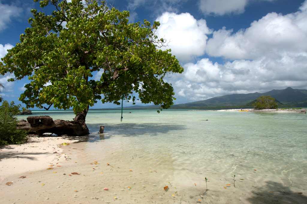
Penieu Island
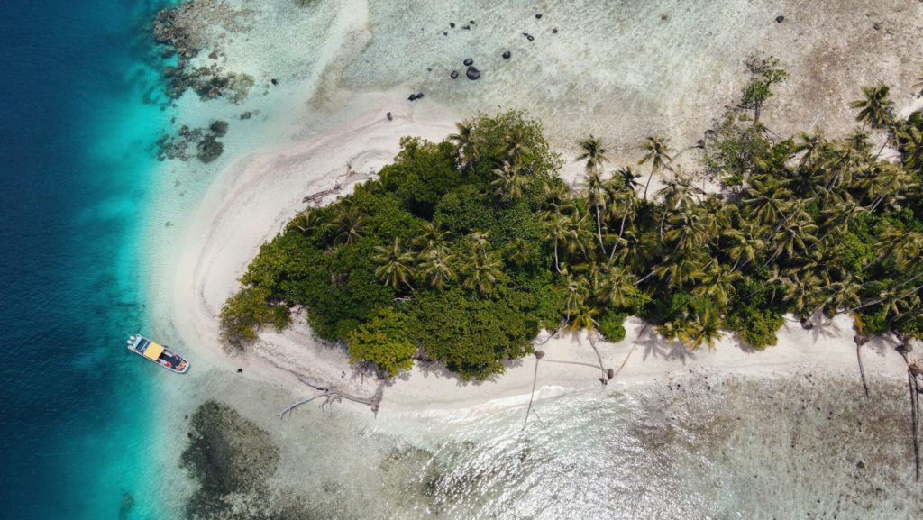
Penieu is a gorgeous reef island in the southeast next to Kepidauen Ne (pass). The island is a major rookery for a colony of noddies and other seabirds, which fill the air with raucous clamor as they swoop around the trees. The primary nesting spot is within a strip of mangroves at the north end of the island (which we’ve dubbed “Noddy City”) and should be given a wide berth to avoid disturbing the habitat of the birds. The island also has a strange, curving sandbar around the north that forms a kind of protected, shallow lagoon with a sandy bottom. This is an excellent place for wading, swimming and playing if you have your kids along, but keep an eye out for stingrays. There are also sandy beaches and good swimming and snorkeling on the west coasts. A pearl farming operation was in progress in the shallow lagoon areas nearby, and a few ramshackle huts were been built on the beach for that purpose (unfortunately, they’re untidy and don’t add much to the scenery). Currents can be quite strong around the eastern side of the island.
- Camping is possible on Penieu, which is owned by the Nahnmwarki of Kitti. Unfortunately, it’s difficult to get him or a family representative on the phone. If you’re interested in visiting, contact the Kitti Municipal Government Office at +691.320.5038, 320.5808, 320.5049, or 320.3257 and ask for assistance.
Nahkapw Island
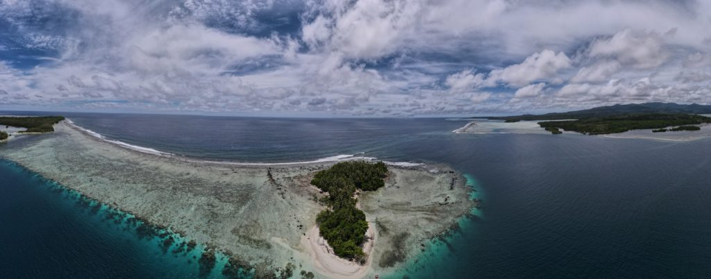
Nahkapw is the island directly across from Nan Madol, and if you want to stay overnight and explore the ruins over a couple of days, this is the place to camp. The island is composed of coral rubble and thickly forested. Sandy beaches lie around the north and northeast coasts and there’s a nice protected, shallow place to swim on the west coast inside the boulder break-wall. The latter is believed to have been constructed during the Nan Madol Period or perhaps even before. Legends speak of two ancient stone cities that pre-dated Nan Madol; one of these is said to lie beneath or beyond Nahkapw. Some archaeologists have proposed that the island itself is man-made, but though much of the western and northern coastlines are surrounded by gigantic basalt boulders that are certainly not natural to the area, there doesn’t seem to be any columnar basalt around Nahkapw. The island has an irregular shape. The best swimming is off the north end, where the beach drops straight off into the deeps of Pahn Nahkapw — a huge “blue hole”. The snorkeling and SCUBA diving around the west edge of the reef wall (next to the boulder line) and to the northeast is excellent.
- To obtain permission for overnight stays, call Hentrick Etse at +691.320.8782.

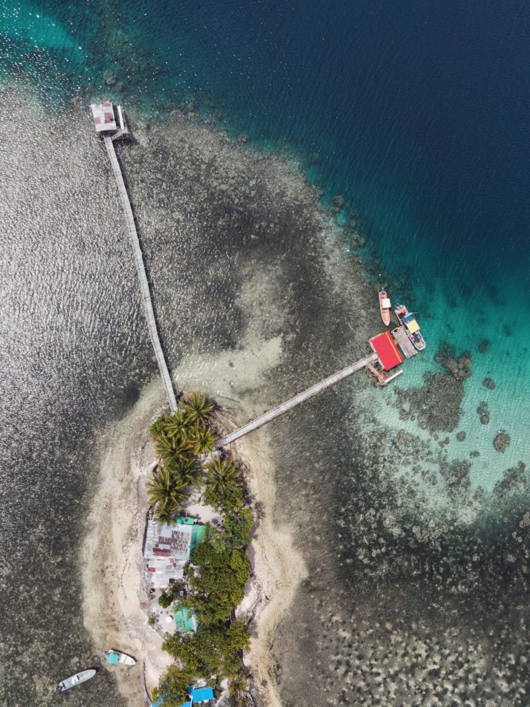
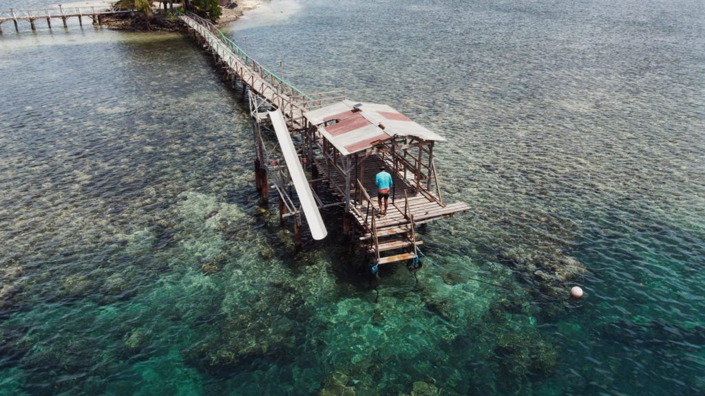
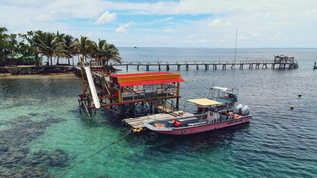
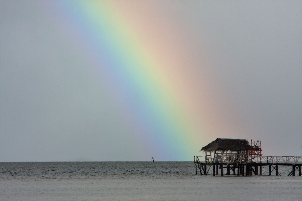
Nahlap Island
")
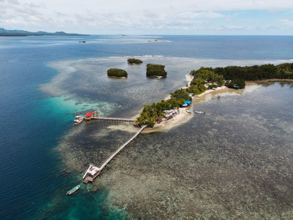
Nahlap remains one of Pohnpei’s most accessible and popular lagoon getaways, but visitors should be aware of the facilities and island conditions.
Many of the huts have basic amenities, but water access varies. Some huts, including the nahs (traditional meeting houses), currently have limited water systems. Toilets in the nahs are bucket-flush only, and there is no shower water available at those locations. Showers are available at some of the other huts, where water tanks are still functional. The larger green and blue huts appear to be the most maintained, with the blue hut offering the best bathroom facilities (still bucket-flush, but with a larger tank).
The boat service to Nahlap is typical of local lagoon transport — reliable enough but basic, without luxury features and not always the most comfortable ride. Travelers looking for a faster or more comfortable experience might consider working with a tour company or arranging a private charter.
Currently, major reinvestment in the property appears limited. However, Nahlap’s natural beauty still offers plenty for visitors to enjoy. The north end of the island, beyond the small church, feels particularly untouched and peaceful, with dense tropical plant life and mature trees providing shade and a true sense of isolation.
Key Points for Visitors:
• Bring extra drinking water and be prepared for limited freshwater availability.
• Facilities are basic: bucket-flush toilets, limited or no shower water in some huts.
• Boat transport is local-standard; tour companies or private charters may offer alternatives.
• Best suited for travelers seeking a rustic, nature-focused island experience.
Getting there:
Launch at Sekeren Iap in Rohnkitti (~21 km southwest of Kolonia). Continue past the Henry Nanpei Memorial and Rohnkitti Church to the end of the road.
Reservations and Boat Arrangements:
To make reservations or arrange for a boat taxi from Sekeren Iap in Rohnkitti, call +691 925 9797
Or contact the Kitti Municipal Government Office: (+691)320-5038 / 320-5808 / 320-5049 / 320-3257
Marine Attractions GPS Data
Marine Attractions GPS Data
Downloadable GPS Data Files
The following files contain all the packaged GPS data for each feature or attraction on the Marine Attractions guide.
Three file types are provided. KMZ and KML files are compatible with Google Earth. KML is compatible with Google Maps. GPX files can be imported into ArcGIS (a professional mapping application) and some hand-held GPS devices.
[info]NOTE: All files are free to the public and can be used for any purpose without permission.[/info]
Coastline
These lines were drawn during the course of this project from existing aerial photography and satellite imagery.
- Pohnpei Island Coastline (2013) – KMZ format (284 kb)
- Pohnpei Island Coastline (2013) – KML format (753 kb)
- Pohnpei Island Coastline (2013) – GPX format (1.1 mb)
Mangroves
Including all mangrove forests around Pohnpei Island and its lagoon islands; these lines were drawn during the course of this project from existing aerial photography and satellite imagery.
- Mangrove Forests (2014) – KML format (5.3 mb)
- Mangrove Forests (2014) – KMZ format (1.8 mb)
- Mangrove Forests (2014) – GPX format (7.8 mb)
Reefs
These lines were drawn during the course of this project from existing aerial photography and satellite imagery.
- Pohnpei Island Reef System (2014) – KMZ format (3.2 mb)
- Pohnpei Island Reef System (2014) – KML format (9.1 mb)
- Pohnpei Island Reef System (2014) – GPX format (13.3 mb)
Surf Breaks
Locations were marked based on data provided Pohnpei Surf Club.
- Pohnpei Surf Break Locations (2015) – KMZ format (5 kb)
- Pohnpei Surf Break Locations (2015) – KML format (17 kb)
- Pohnpei Surf Break Locations (2015) – GPX format (11 kb)
SCUBA Diving & Snorkeling
Locations were marked based on data provided by knowledgeable local diving guides and our own on-the-ground data gathering experiences.
- Pohnpei SCUBA Diving & Snorkeling (2014) – KMZ format (50 kb)
- Pohnpei SCUBA Diving & Snorkeling (2014) – KML format (188 kb)
- Pohnpei SCUBA Diving & Snorkeling (2014) – GPX format (179 kb)
Swimming Spots
Locations where poor water quality or environmental contamination make them unsafe for swimming have not been included here. This includes all of the watercourses around Mand, Madolenihmw Municipality (with one exception) and almost everything in Sokehs Municipality. Locations are GPS-verified.
- Swimming Spots (2014) – KMZ format (5 kb)
- Swimming Spots (2014) – KML format (40 kb)
- Swimming Spots (2014) – GPX format (8 kb)
Paddling (Suggested Kayaking, Canoeing & Paddleboarding Routes)
All data was gathered first-hand during this project (all of these routes were paddled); routes are GPS-verified.
- Kayaking & Paddleboarding Routes (2014) – KMZ format (539 kb)
- Kayaking & Paddleboarding Routes (2014) – KML format (1.6 mb)
- Kayaking & Paddleboarding Routes (2014) – GPX format (2.2 mb)
Marine Parks in Awak Pah (2015)
Marine Protected Areas, Mangrove Forest Reserves, and Sanctuaries
Shapes are approximations based on data and maps provided by Conservation Society of Pohnpei (CSP) and were not GPS-verified in the course of this project.
- Pohnpei Marine Protected Areas (2013) – KMZ format (17 kb)
- Pohnpei Marine Protected Areas (2013) – KML format (57 kb)
- Pohnpei Marine Protected Areas (2013) – GPX format (65 kb)
Coordinates
The following coordinates correspond with sites featured on the Marine Attractions Eco-Adventure Map Guide. It is our dream to eventually create a Pohnpei GPS app that could be uploaded to smartphones and other devices, but for now, these points of interest can be entered manually in a hand-held GPS device as needed.
[info]NOTE: All GPS devices have a margin of error. That margin increases with interference — when there is a thick canopy of trees, during bad weather, or when mountains obstruct the satellite link.[/info]
Awak Marine Parks
| Awak Pah MP Entrance | —- | 6.965910° 158.250758° |
| Pein Ahi Entrance | —- | 6.966711° 158.251138° |
| Paieke Entrance | —- | 6.969853° 158.256294° |
| Awak Pah MP Dock | —- | 6.966470° 158.248785° |
| Pein Ahi Fish Pond | —- | 6.967572° 158.249929° |