
Timwen Men, Dolakapw & Pohn Tehnmei
North Madolenihmw Hikes
![]()
![]()
![]()
![]()
![]()
The northernmost section of Madolenihmw is separated from the rest of the municipality by a range of low mountains that run east-west from Mesihsou to Alohkapw. This range was fortified by the Japanese army during World War II because it was easily accessible and commanded excellent views of lands both to the north and the south. The hills are riddled with tunnels and man-made caves, and a ridge path runs from the east end and connects with the primary mountain system in the central part of the island. There was a time when Japanese soldiers could travel from Mesihsou all the way to Kupwuriso without ever leaving the mountains. Small 75-80 mm guns were also installed at hidden spots among the hills.
There are many potential hikes one could do in these interesting mountains, but we’ve chosen to focus on three routes leading to small peaks along the ridge: Timwen Men, Dolakapw, and Pohn Tehnmei. All three cross private land.
Timwen Men
The name of this small peak at the western end of the ridge means “beak of the bird,” a reference to the many brown noddies that can be seen flying around the summit. The hike begins at the houses near the end of the road, belonging to the extended family of Eiber Rosario, and passes through the family’s sakau plantation on the slope. Any semblance of a trail vanishes at the foot of the hill, where you have to clamber up the steep, muddy hillside. At the top, there’s an extensive network of Japanese defensive trenches. The Japanese ridge path goes east as far as Mesihsou and west to Kupwuriso, but the problem with hiking the entire distance in one go is that the mountain range is broken up into a number of private parcels owned by different (and sometimes competing) families. The trail is easy to follow as it goes west toward the Timwen Men summit (331 m / 1,086 ft). Along the way, you’ll pass several impressive tunnels that bore into the hill and connect with the trench system. Two circular pits seem to have been either small caliber gun stations (possibly 80 mm) or rifle positions. No guns are found there now. The summit is a little overgrown, but still affords nice views of the valley.
- The hike takes about 3 hours round-trip.
- To arrange for a guide, ask for the colorful Eiber Rosario at the houses near the end of the road. You may also be able to locate Eiber by calling his son-in-law, Colton, at +691.923.6941. Offer $20.
Dolakapw (Edienleng)
This hike starts at the main road opposite a small store, passes through a group of houses, and follows a well-traveled footpath, climbing steadily but never steeply to Dolakapw (“new hill”), a peak in Edienleng. The trail ends at a plantation of sakau and other agroforestry crops. From there the route curves around the south side of the hill (with views of the Sapwalap plain), where two large Japanese tunnels burrow into the slope. The lower one is partially collapsed, the steel rails for a mining car still jutting out of the hole. The roof here is unstable, so it would be unwise to venture inside. The tunnel is about 15 meters long. The second tunnel, a little higher up the hill, is in better shape with U-shaped steel supports holding up the rocky roof. Bats and Caroline Islands swiftlets nest at the rear. The landowner believes that the Japanese intended to connect the two tunnels, but abandoned the project once the Allied bombing campaign began. The semi-open Dolakapw summit (305 m / 1,001 ft) is just above.
- The hike takes about 3 hours round-trip.
- To find a guide, visit the small store on the coastal side of the road and ask for Isaac Fred. Offer $20.
Pohn Tehnmei
This short, strenuous hike begins at the home of brothers Atsent and Romeo Welcher at the end of an intermittently paved road west of Nan Pailong. There isn’t much of a trail; the route just goes straight up the slope behind the house along an eroded track used to drag huge sakau pounding stones, called peitehl, down from the mountaintop. The first thing encountered at the top is the quarry site itself — a collection of pits from which the stones have been dug. There was a time when people came from all over the island to get peitehl at this spot. Currently, the state forbids the practice, but you may get the distinct impression that it’s still going on nonetheless. Not far from the top of the hill, a gigantic peitehl marks the spot where the brothers Olsihpa and Olsohpa looked down and first laid eyes on Sounahleng, the place where they would eventually begin the building of Nan Madol (there’s no view from here now, unfortunately). Also, a trio of large stones slightly to the west are said to have been formed from the bodies of a man, his wife, and their child. From there you can continue west along the ridge to the Pohn Tehnmei summit (347 m / 1,138 ft). The tree cover on the ridge, however, obscures any good views of the lowlands.
- Plan for about 2 to 3 hours round-trip for this adventure.
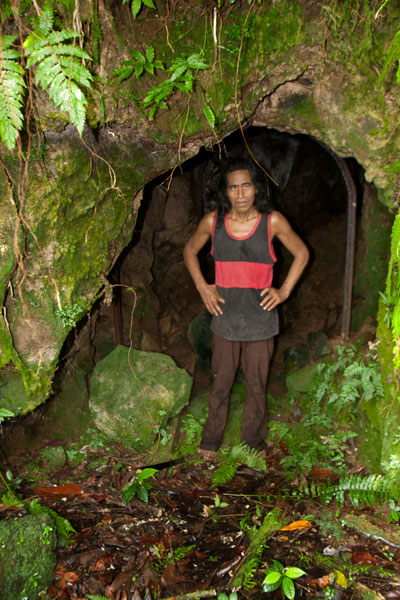
Japanese Tunnel
At the base of the hill on the Welcher farmstead is a 14 meter-long curving Japanese tunnel. Mining car rails lie along the floor, and though the mouth of the cave is partially collapsed, the rest is supported by U-shaped steel supports. You can enter carefully and walk to the end (bring a headlamp or flashlight and expect some bats).
- Either Atsent or Romeo Welcher (+691.925.8075) can be hired as guides, though Romeo’s English is better. If you can’t get them by phone, just go to the house and ask one of them to take you up. Offer $20.