
Sokehs Japanese Sites & Parpwu Waterfall
Historical Sites in Mainland Sokehs
![]()
![]()
![]()
![]()
![]()
![]()
![]()
“Military Road” Hike / Bike Tour
One of the most rewarding routes for Japanese World War II-era historical sites follows a road 0.46 km (0.29 mi) northeast of the turn-off to the FSM capital. This track was built by the Japanese in the 1930s to access the many military sites in the area and remains unpaved. Whether it is public or private, however, seems to be a matter of some debate. FSM Telecom, which maintains a mobile phone tower near “Radar Station Hill” and uses the road often, says that the road and the areas immediately alongside it belong to the municipality and that people living beyond the Thomas residence are squatters without legal land claims. Even so, a family living on the south side of the road about 1 km (0.62 mi) from the Circle Island Road insists that everything beyond their house is private. There are two ways for visitors to deal with this issue: either (1) hire a knowledgeable local guide to escort you on your hike (you’ll likely find more with them anyway) or (2) visit the house in question and ask permission yourself. During our fieldwork, we used both options successfully. The road, though unpaved, is in pretty good condition, and as it doesn’t climb much, it’s a great choice for either hiking or biking. You can park your vehicle at the beginning near the Circle Island Road and go from there.
")
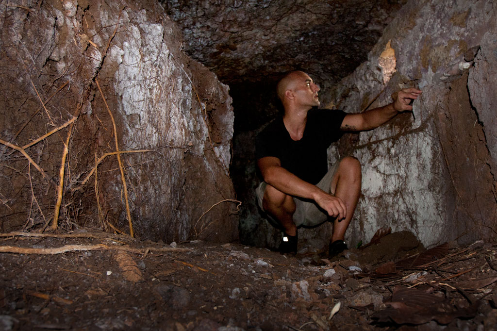
“Bunker Hill”
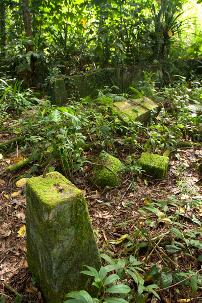
About 100 m (109 yd) from the starting point, you can cut off the road to the right and climb up the grassy hill, making your way toward the landowner’s house about 200 m (219 yd) to the northeast. This is the place to ask for permission to explore in detail. There are several points of interest worth looking into. At the southwest and northeast ends of the hill, there are bunker-like observation stations that consist of curved tunnels with domed concrete roofs and several gun ports. The southern bunker site is well-hidden with the entrance near the base of a large tree that has grown up in recent years. Entering is a dirty job, but once you’re inside, the structure becomes quite roomy. The gun ports allow light inside. The northern site is close to a large cassava plantation and is kept cleared. You can enter easily from either end. These structures were likely manned by a few riflemen and intended to protect the roads on both sides of the hill. In view of the landowner’s house you can also find a zigzag trench and two gun sites, one of which was probably a medium-sized anti-aircraft gun. No guns remain now. Some people believe a gun at this location shot down the American bomber “Love Bug”. Others say it was one on Dolen Pahniepw.
Paul Thomas’s Hill
Another 277 m (303 yd) further down the road, one comes to the residence of a friendly West Virginian native, Paul Thomas, and his local wife. Thomas enjoys a good chat, and if you ask politely, will happily point you in the direction of several interesting sites on the hill above his house. Easily found are two pairs of bunkers similar to those mentioned already, and between these, three small gun sites and several foxholes. Thomas keeps the hill trimmed and neat; all but one of the sites (the first set of bunkers) lie along the crest of the hill over a distance of about 125 m (137 yd). The hill commands sweeping views of the Palikir valley to the west.
- If you want to make arrangements ahead of time, call Paul Thomas at +691.320.4562.
")
Dolen Pahniepw
The next stop is Dolen Pahniepw. An overgrown trail begins off the right side of the road 0.56 km (0.35 mi) past Thomas’s driveway and runs 0.43 km (0.27 mi) to the summit of the hill. About 300 m (328 yd) along the trail, one comes to the ruins of an army barracks, which consists of concrete house posts,
foundations, and a bombed-out cistern. Sets of concrete steps led to the entrances of the wooden buildings. Some scrounging in the jungle around the site should yield some old Japanese beer bottles. At the end of the trail is a large anti-aircraft gun site, which probably housed a medium-sized gun similar to those on Lenger Island. On the northeast side of the hill, you may be able to locate the foundation of a radio tower, some tunnels, and the chassis of a truck.
At the southern end of the hill near the road, you can scramble up the bank and find a pair of unfinished small gun emplacements, some trenches in the woods, and a defused bomb.
“Radar Station Hill”
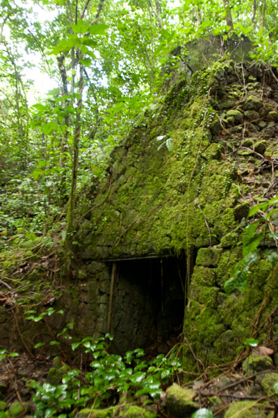
The road ends near the FSM Telecom cellular phone tower at the summit of a hill. A footpath continues west to a cement platform for a Japanese radar array, two foxholes, and two circular gun sites. A large bomb crater south of the road makes an excellent tent site for campers with unobstructed views of the whole of mainland Sokehs. Back east down the road, an L-shaped cutting leads to a path and eventually to the site of a generator station with a concrete storage alcove built into the embankment and a rusting motor.
- Plan for a half day to full day for this hike/ride, depending on how many sites you want to explore.
- No guide is necessary for the Military Road sites as long as you ask permission wherever private land is an issue. However, you are likely to discover much more of interest with a guide who knows the sites. Please visit the Local Guides & Tour Operators page for a list of experienced guides available for hikes around Sokehs, if desired. Offer $25-50 for a group of five or less.
PBJ-H1 “Love Bug” Bomber Ruins
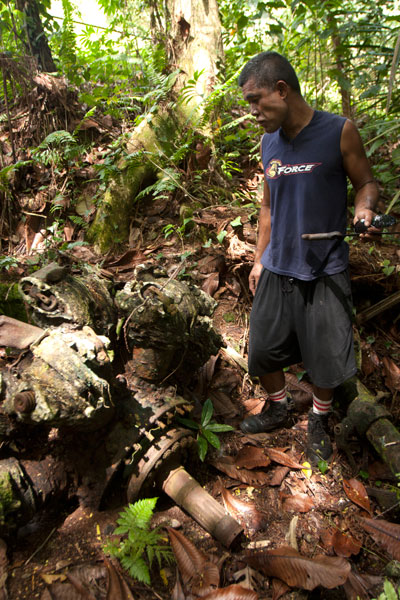
Throughout 1944 and early 1945, the U.S. carried out a brutal bombing campaign of Japanese fortifications on Pohnpei. The only bomber ever shot down was a PBJ-1H (the U.S. Marines version of the Airforce B-25H) nicknamed “Love Bug” and piloted by First Lieutenant William J. Love. On February 6, 1945, while on a mission to destroy targets at the nearby Palikir airfield, the Love Bug was picked out of the sky by an anti-aircraft gun on one of the nearby hills (possibly “Bunker Hill”, Paul Thomas’s hill, or Dolen Pahniepw). The plane burst into flames upon impact, killing the entire crew. After the crash, Japanese soldiers collected the bodies and buried them in a marked grave near the crash site. A monument to the crew used to be found at the burial site, but it was taken apart by looters in the 1980s.
The crew was disinterred and reburied several times during the American Period before coming to rest at Jefferson Barracks National Cemetery in the U.S. — all except Sgt. David Snider, whose whereabouts were unknown until 1948. The wreckage was not positively identified until 2001, when two aviation archaeologists surveyed the area. The tail section and rudder were still visible in the forest in the 1980s, but the site has been heavily looted since and only a few large pieces remain — the port engine (sans prop), landing gear and wheel, and a portion of a stabilizer. Bits of wreckage are strewn across an area of some 7,000 square meters. Three defused bombs are also said to be in the vicinity, but we were unable to locate them during our visits.
It’s easiest to visit the site from the unpaved water tank road behind the FSM presidential housing facility. No guide is necessary, but you’ll have to ask the officer at the security check-point to let you through. The wreck is found on the forested slope a few meters off the north edge of the road before the water tank.
- Plan for 1 hour for this hike. No guide is necessary, but you will need to ask the security guard on the road to let you through.
Nankewi River Vicinity
Ethanol Manufacturing Site
On the banks of Pillapen Nankewi (Nankewi River) the remnants of Japanese industry can still be seen. Neat stone retaining walls frame the river and trenches and pipes form a grid on the north bank. On the south bank are three large fermentation tanks, a variety of other distilling gear, brick ovens built into the hillside, a huge press, a crank, and other rusting machinery. The equipment was likely used to distill ethanol from sugar cane for fuel and other industrial purposes. A great deal of Japanese beer and liquor bottles litter the spot.
Parpwu Waterfall
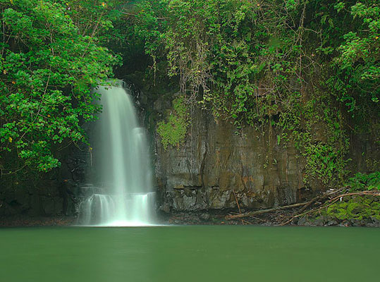
The rather flat terrain in greater Sokehs doesn’t make for a lot of waterfalls, but Parpwu (a.k.a. “Nan Lohlo” or “Nankewi”) — located on the Nankewi River just behind the now deserted Sokehs Shopping Center — is unusual because it’s so close to the coast, almost in the mangroves. In fact, during very high tides, you can kayak all the way from Sokehs Bay to the falls. The waterfall is a beautiful sight, but unfortunately, upstream piggeries have polluted the watercourse and swimming is ill-advised (even though you’ll see local kids from the area doing just that). Photo courtesy of Bill Jaynes.
- Plan for 1 hour for this hike. Its easy to find someone to guide you down to the falls and/or distillery site. Just ask in the area. Offer $6.00.
Madolenihmw Bay Area
![]()
![]()
![]()
![]()
![]()
![]()
![]()
![]()
![]()
![]()
![]()
![]()
![]()
![]()
![]()
Dauen Sapwalap / Senipehn Mangrove Reserve
- Visit the Paddling Around Madolenihmw page for a detailed description of this location and the adventures to be had in the area.
- Entering the mangrove reserve requires a permit. Visit our MPA page for details.
Kamau Pwoungapwoung
Though we didn’t map the hike to this destination as part of the eco-adventure map series (for lack of time), it would, never the less, be an exciting adventure to consider. Kamau Pwoungapwoung refers to a freshwater pool and waterfall at the headwaters of the Dipwilap Stream (Pilen Dipwilap), one of the tributaries of the Senipehn River (Pillapen Senipehn). The place is significant as the location where the last battle between the Saudeleur‘s warriors and Isokelekel’s men was fought. Upon being defeated by Isokelekel, the Saudeleur transformed himself into a small blue fish, that inhabits the pool to this day, and leaped into the waterfall. The hike would be a long one from the area around Pahn Sile. The closest access point would probably be from the direction of Nihpit fern meadow (reached from eastern Kitti).
- The absolute best choice for a guide is Relio Lengsi. Give him a call at +691.924.2580 and discuss the best route options and access points for this location. Offer $50.00 for a full-day hike.
Nanpahlap Peak
The 137 m (449 ft) hill to the east of Takaiuh looks as if its top has been lopped off — which fits in with the story about its creation (see Takaiuh below). Though steep in places and somewhat overgrown, the ascent isn’t too strenuous. At the summit are the tumbled ruins of a prehistoric stone structure and a breath-taking view. The whole area around the southern foot of the hill is criss-crossed with Japanese trenches and dotted with tunnels, including at least one very long one leading into the hill. The grid of paddies and irrigation canals where the Japanese successfully cultivated rice (despite Pohnpei’s challenging climate conditions) are found on both sides of the unpaved access road, though you can get closest to the bulk of these fields from another road to the west.
Everything is private land, but no official access fees are charged.
- To hire a guide, ask at the houses in the area or contact Hanke Albert at +691.320.4047. Offer $25.00 for Nanpahlap or a half-day of exploration in the area.
Nanwap Marine Protected Area (MPA)
Nanwap Marine Protected Area is a 3.05 km2 (305 hectare) section of the barrier reef and adjacent lagoon areas on the north side of Kepidauen Deleur (passage). The sanctuary was founded by community members from Metipw and Lukop and their respective chiefs and gained legal status in 2010. It became the first of Pohnpei’s MPAs to have its own formal community-created management plan with the support of the Pohnpei MPA Executive Management Network and the state offices of the Department of Land and Natural Resources, Division of Fish and Wildlife, Office of Fisheries and Aquaculture, and Environmental Protection Agency. Nanwap is a “no-take zone,” which means no fishing or gathering of any kind is allowed within the boundaries. It is regarded as the “most biologically diverse and best preserved spawning and aggregation site” for many of Pohnpei’s core reef fish species. Snorkelers should seek out the protected blue holes on the west side of the reef, while SCUBA divers will want to do a drift dive on the southern wall of the reef during an in-coming tide.
- Entering the MPA requires a permit. Visit our MPA page for details.
Pahn Dieinuh
- Visit the Paddling Around Madolenihmw page for a detailed description of this location.
Peiai
Peiai is a small populated place near the turn-off for Pahn Sile waterfall. During the battle between the warriors of Isokelekel and the army of the last Saudeleur, Peiai was the place where the tide of battle turned dramatically (hence, the name references a situation where the runner-up in a race pulls ahead of the leader — loosely translated “the battle is reversed”). Isokelekel’s men were being beaten down by the forces of Nan Madol when one of the conqueror’s greatest fighting men pinned his own foot to the ground with his spear, refusing to retreat and declaring that he would kill any man who tried to run away from the fight. Isokelekel’s men rallied behind this show of bravery and pushed back the Saudeleur‘s warriors, chasing them up the Senipehn River and eventually to Kamau Pwoungapwoung, a waterfall at the headwaters of the Dipwilap Stream, where the Saudeleur was finally defeated.
Sapwalap
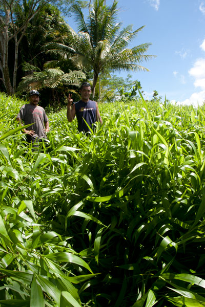
Sapwalap (“large land”) is an expansive region of mostly flat ground that makes up a sizable chunk of central Madolenihmw. The Japanese recognized Sapwalap‘s potential as a site of large-scale agriculture. During the thirty years leading up to World War II, sugarcane was cultivated and processed at a facility near Kitamw (the tower is still partly visible in the jungle off the road) and rice was grown in a patchwork of paddies fed by irrigation canals. Strangely, no one is growing rice these days, but the paddies are still there opposite the gleaming LDS Church. Other fields are found as far east as Lukop.

Tahio
Tahio, on the south side of Nanpahlap, is another place where the Japanese were active. The access road was built by them and the coastal area is full of trenches, rifle pits, dugouts, and tunnels. Everything is overgrown, but anyone who pokes around will be rewarded with interesting finds. Bring a local resident along.
Takaiuh Peak
You can’t visit Madolenihmw without being arrested by the sight of Takaiuh, a 160 m (525 ft) peak shaped like a traffic cone that stands on the north side of the bay and seems to guard the entrance to the Sapwalap estuary. The mythical origin-story of the hill — which bears a striking resemblance to the Biblical tale of the tower of Babel — involves Mwohnmur and Sarapwau, two wily brothers who enter into many Pohnpeian legends (they also created the Sahwar Valley and the rock of Pohnpaip).
How Takaiuh Came to Be
Long ago, two boys named Mwohnmur and Sarapwau were born in Salapwuk (Kitti) to a woman named Lienlama. The boys were always involved in clever schemes and mischief and traveled far and wide doing great works. Once, the brothers took a piece of stone, and using it like a canoe, paddled to Pohndolen Imwinsapw near what is now Tahio in Madolenihmw. There, Mwohnmur and Sarapwau amused themselves by piling up rocks until they had formed a large hill. A local demi-god named Lapongo saw what they were doing and wasn’t pleased, so he threw a stone at their hill and destroyed it. He then challenged the brothers to a competition to see who could build a mountain the fastest. The three set to work, but it soon became apparent that the boys were winning. Their mountain was so tall it had reached the sky. Being a poor loser, Lapongo became enraged. He picked up a stone and threw it at the new mountain, which broke into six pieces. The base of the mountain that remained standing was named Takaiuh (“standing stone”).
This was not the end of the conflicts between the brothers and Lapongo, however. Lapongo mocked and ridiculed the boys whenever he could, and they did not like it. Now, the brothers liked to play at a place called Pahnlikes, below the spot where they had settled on Likes peak west of modern-day Sapwalap. There was a steep slope there that they would slide down for fun, sitting upon the leaf sheaths of the kotop palm (Clinostigma ponapensis). The boys knew that Lapongo had been watching them and was aware of their play place, so they decided to trick him. Lapongo was invited to slide down the slope with the boys, but they chose a spot where the slope ended at the waterside (possibly the southern tributary of Pilen Kitamw). All three began sliding down the hill. When Mwohnmur and Sarapwau reached the bottom, they leaped off their sheaths and dived to safety, but Lapongo went straight and fell into the water. He sank down into the depths, and the brothers threw rocks on top of him to keep him from resurfacing.
Takaiuh is actually an island separated from the coast by a strip of mangrove forest. It was once inhabited, but is no longer. Though the hill is climbable, the ascent is extremely dangerous, characterized by very steep slopes and cliffs prone to rockslides with little or nothing solid to hold on to. For this reason we strongly advise visitors to enjoy Takaiuh from below rather than trying for the summit. Hikers who insist on seeking the summit, do so at their own risk. Distant views of the peak are found along the Circle Island Road, but the best close-up view from land is from the old Japanese road in Kepine. According to residents living in the area, the Japanese abandoned an attempt to build a trail all the way to the top of the hill. Some of the low wall can still be seen on the lower slope.
Timwen Men, Dolakapw & Pohn Tehnmei
North Madolenihmw Hikes
![]()
![]()
![]()
![]()
![]()
The northernmost section of Madolenihmw is separated from the rest of the municipality by a range of low mountains that run east-west from Mesihsou to Alohkapw. This range was fortified by the Japanese army during World War II because it was easily accessible and commanded excellent views of lands both to the north and the south. The hills are riddled with tunnels and man-made caves, and a ridge path runs from the east end and connects with the primary mountain system in the central part of the island. There was a time when Japanese soldiers could travel from Mesihsou all the way to Kupwuriso without ever leaving the mountains. Small 75-80 mm guns were also installed at hidden spots among the hills.
There are many potential hikes one could do in these interesting mountains, but we’ve chosen to focus on three routes leading to small peaks along the ridge: Timwen Men, Dolakapw, and Pohn Tehnmei. All three cross private land.
Timwen Men
The name of this small peak at the western end of the ridge means “beak of the bird,” a reference to the many brown noddies that can be seen flying around the summit. The hike begins at the houses near the end of the road, belonging to the extended family of Eiber Rosario, and passes through the family’s sakau plantation on the slope. Any semblance of a trail vanishes at the foot of the hill, where you have to clamber up the steep, muddy hillside. At the top, there’s an extensive network of Japanese defensive trenches. The Japanese ridge path goes east as far as Mesihsou and west to Kupwuriso, but the problem with hiking the entire distance in one go is that the mountain range is broken up into a number of private parcels owned by different (and sometimes competing) families. The trail is easy to follow as it goes west toward the Timwen Men summit (331 m / 1,086 ft). Along the way, you’ll pass several impressive tunnels that bore into the hill and connect with the trench system. Two circular pits seem to have been either small caliber gun stations (possibly 80 mm) or rifle positions. No guns are found there now. The summit is a little overgrown, but still affords nice views of the valley.
- The hike takes about 3 hours round-trip.
- To arrange for a guide, ask for the colorful Eiber Rosario at the houses near the end of the road. You may also be able to locate Eiber by calling his son-in-law, Colton, at +691.923.6941. Offer $20.
Dolakapw (Edienleng)
This hike starts at the main road opposite a small store, passes through a group of houses, and follows a well-traveled footpath, climbing steadily but never steeply to Dolakapw (“new hill”), a peak in Edienleng. The trail ends at a plantation of sakau and other agroforestry crops. From there the route curves around the south side of the hill (with views of the Sapwalap plain), where two large Japanese tunnels burrow into the slope. The lower one is partially collapsed, the steel rails for a mining car still jutting out of the hole. The roof here is unstable, so it would be unwise to venture inside. The tunnel is about 15 meters long. The second tunnel, a little higher up the hill, is in better shape with U-shaped steel supports holding up the rocky roof. Bats and Caroline Islands swiftlets nest at the rear. The landowner believes that the Japanese intended to connect the two tunnels, but abandoned the project once the Allied bombing campaign began. The semi-open Dolakapw summit (305 m / 1,001 ft) is just above.
- The hike takes about 3 hours round-trip.
- To find a guide, visit the small store on the coastal side of the road and ask for Isaac Fred. Offer $20.
Pohn Tehnmei
This short, strenuous hike begins at the home of brothers Atsent and Romeo Welcher at the end of an intermittently paved road west of Nan Pailong. There isn’t much of a trail; the route just goes straight up the slope behind the house along an eroded track used to drag huge sakau pounding stones, called peitehl, down from the mountaintop. The first thing encountered at the top is the quarry site itself — a collection of pits from which the stones have been dug. There was a time when people came from all over the island to get peitehl at this spot. Currently, the state forbids the practice, but you may get the distinct impression that it’s still going on nonetheless. Not far from the top of the hill, a gigantic peitehl marks the spot where the brothers Olsihpa and Olsohpa looked down and first laid eyes on Sounahleng, the place where they would eventually begin the building of Nan Madol (there’s no view from here now, unfortunately). Also, a trio of large stones slightly to the west are said to have been formed from the bodies of a man, his wife, and their child. From there you can continue west along the ridge to the Pohn Tehnmei summit (347 m / 1,138 ft). The tree cover on the ridge, however, obscures any good views of the lowlands.
- Plan for about 2 to 3 hours round-trip for this adventure.
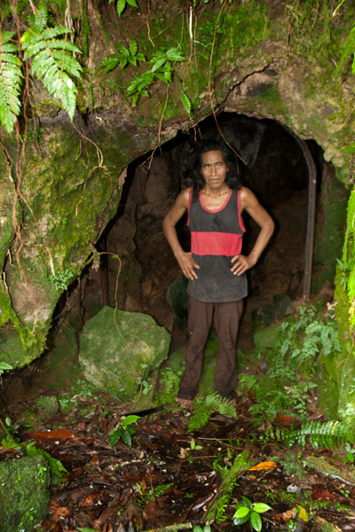
Japanese Tunnel
At the base of the hill on the Welcher farmstead is a 14 meter-long curving Japanese tunnel. Mining car rails lie along the floor, and though the mouth of the cave is partially collapsed, the rest is supported by U-shaped steel supports. You can enter carefully and walk to the end (bring a headlamp or flashlight and expect some bats).
- Either Atsent or Romeo Welcher (+691.925.8075) can be hired as guides, though Romeo’s English is better. If you can’t get them by phone, just go to the house and ask one of them to take you up. Offer $20.