

Pahn Sile Waterfall
![]()
![]()
![]()
![]()
![]()
![]()
![]()
![]()
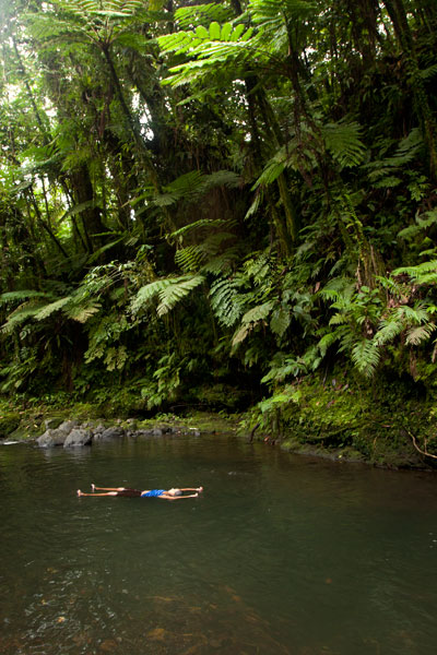
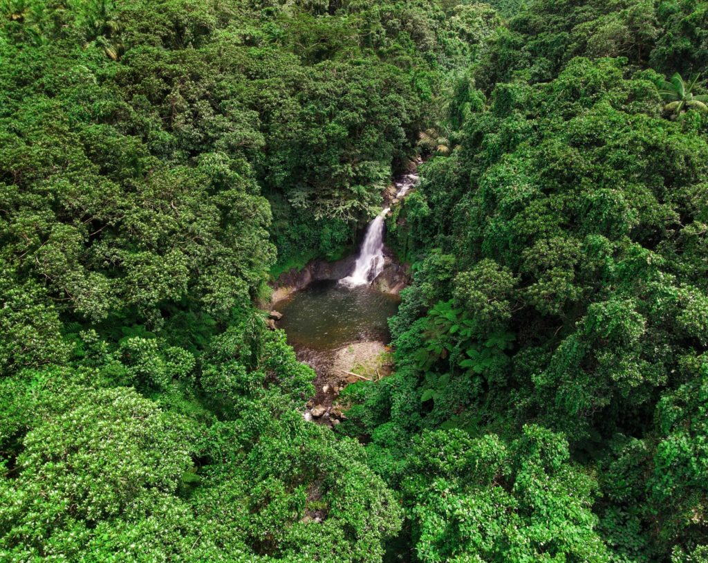
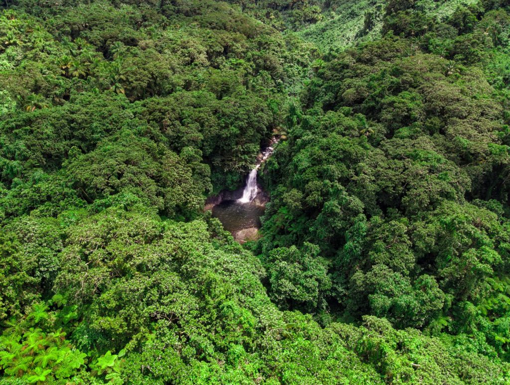
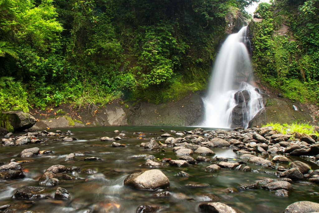
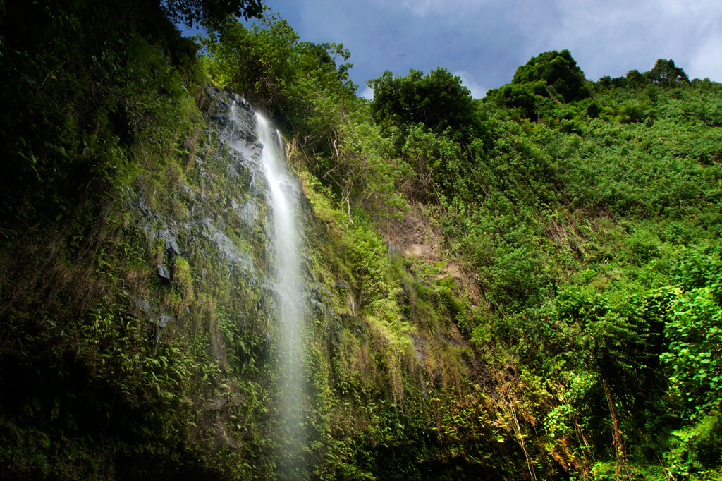
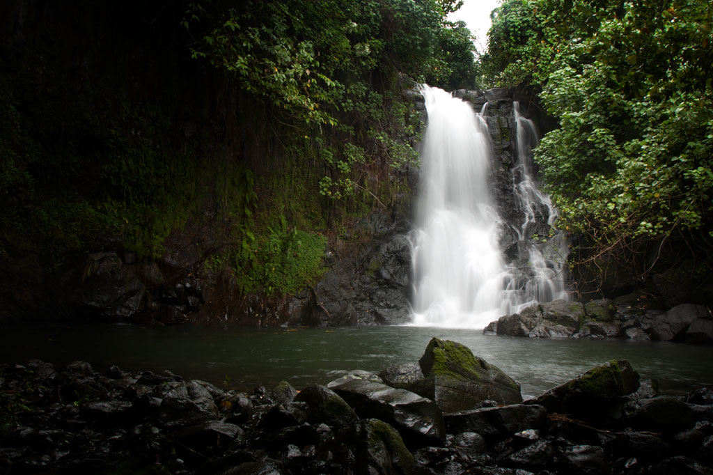
Located on the pristine Senipehn River, Pahn Sile is one of the few waterfalls well into the interior that almost anyone (even small children) can reach without the help of a guide — as long as you keep your eyes open for the branches in the path. A well-maintained trail begins at the end of the unpaved but well-graded coral and gravel road beyond Sapwalap Elementary School and opposite a concrete taxi stop. Houses are found along the path for much of the way, as well as historic rock-lined irrigation canals built by the Japanese. About 0.15 km (164 yd) before reaching the waterfall, a secondary path branches right and descends to a shallow point in the river, where you’ll cross and hug the right bank or walk in the stream as you continue to the falls just around the corner.
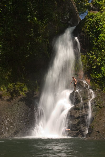
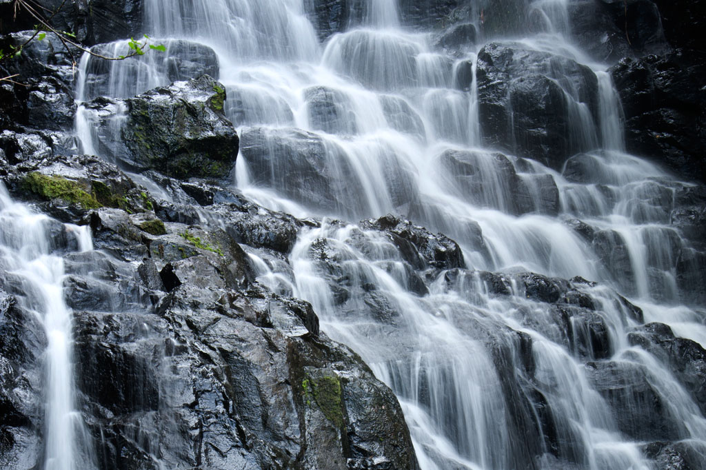
Pahn Sile‘s pool is wide and wonderfully cool, but not especially deep. The falls varies in volume depending on recent rain, gushing through a narrow portal and crashing onto rocks that form the rim of the pool. If you want a view from above the falls, bear left at the branch, proceed for 0.3 km (0.18 mi), and then cut off the trail and head straight toward the sound of the river. There is no path for this last part, but it’s easy enough to move through the forest. There are nice spots for a camp site above the falls in the forest along the path (pack out everything you packed in). In addition to the primary waterfall pool, there’s a small, deep pool just down river that is also an excellent place to swim, shaded by lush ferns and massive trees.
There are no access fees and no permission is needed to visit the falls.
If you would like a guide for the trip to the waterfall contact Raven at (+691)923-1862, he does not charge a fee but we do encourage you to tip him for his time.
- Plan for 3 hours round-trip for this excursion.
(Central) Madolenihmw GPS Data
Downloadable GPS Data Files
The following files contain all the packaged GPS data for each of the featured locations in the (Central) Madolenihmw Eco-Adventure Map Guide.
Three file types are provided. KMZ and KML files are compatible with Google Earth. KML is compatible with Google Maps. GPX files can be imported into ArcGIS (a professional mapping application) and some hand-held GPS devices.
[info]NOTE: All files are free to the public and can be used for any purpose without permission.[/info]
Dolen Merewi Hike (2015)
Madolenihmw Bay Area Attractions (2015)
Nankep Waterfall Hike (2015)
Pahnsapw Waterfalls Hike (2015)
Pahn Sile Waterfall Hike (2015)
Pohnpaip Petroglyphs (2015)
Coordinates
The following coordinates correspond with sites featured on the (Central) Madolenihmw Eco-Adventure Map Guide. It is our dream to eventually create a Pohnpei GPS app that could be uploaded to smartphones and other devices, but for now, these points of interest can be entered manually in a hand-held GPS device as needed.
[info]NOTE: All GPS devices have a margin of error. That margin increases with interference — when there is a thick canopy of trees, during bad weather, or when mountains obstruct the satellite link. The geosynchronous satellites employed when navigating on Pohnpei are located low on the southwestern horizon, such that maintaining a strong connection while hiking on the northeast side of a given mountain range can be difficult. Coordinates on the northeastern slopes of mountains are less accurate than in other locations.[/info]
Dolen Merewi
| Dolen Merewi Turn-Off | —- | 6.882208° 158.290005° |
| Road Branching – bear left | —- | 6.881983° 158.278225° |
| Dolen Merewi Trailhead | —- | 6.880292° 158.274669° |
| Private Residence | —- | 6.880442° 158.274156° |
| Look-Out Point | —- | 6.883006° 158.270929° |
| Dolen Merewi True Summit | —- | 6.882815° 158.270869° |
Madolenihmw Bay Area
| Lukop, Metipw & Kepine Turn-Off | —- | 6.898141° 158.315994° |
| Road Branching – bear left for Lukop and Metipw; bear right for Kepine and Takaiuh | —- | 6.889728° 158.314120° |
| Bridge | —- | 6.884719° 158.313625° |
| Japanese Agricultural Plots | —- | 6.886711° 158.311515° |
| Nanpahlap Trailhead | —- | 6.876366° 158.318225° |
| Nanpahlap Summit | —- | 6.875491° 158.315744° |
| Tahio Trailhead | —- | 6.874010° 158.317018° |
| Japanese Dug-Out | —- | 6.873007° 158.316122° |
| Japanese Trench | —- | 6.872754° 158.315133° |
| Japanese Tunnel | —- | 6.873264° 158.314119° |
| Abandoned Community Hut (nahs) | —- | 6.872849° 158.314316° |
| Takaiuh Summit | —- | 6.872128° 158.310713° |
| Rocky Hill | —- | 6.874429° 158.308532° |
| Dauen Sapwalap Entrance | —- | 6.876938° 158.308196° |
| Japanese Rice Paddies Turn-Off | —- | 6.888314° 158.296764° |
| Japanese Rice Paddies & Irrigation Canals | —- | 6.887325° 158.303652° |
| Metipw Causeway / Launch | —- | 6.878051° 158.333074° |
| Mwudokolos Island | —- | 6.883576° 158.336525° |
| Dahu Reirei Island | —- | 6.888759° 158.344288° |
| “Channel Island” | —- | 6.899494° 158.342153° |
| Nanwap Marine Protected Area | —- | 6.872988° 158.353673° |
| Nahpali Island Dock | —- | 6.861877° 158.354457° |
| Salong Point, Temwen Island | —- | 6.856468° 158.322737° |
| MERIP Boathouse | —- | 6.844010° 158.308539° |
| Madolenihmw Ice Dock | —- | 6.849520° 158.302712° |
| Madolenihmw Bay Scenic Point | —- | 6.855273° 158.295686° |
Nankep Waterfall
| Nankep Waterfall Turn-Off | —- | 6.858738° 158.291440° |
| Bridge | —- | 6.858789° 158.291453° |
| Nankep Waterfall Trailhead | —- | 6.859867° 158.286390° |
| Nankep Waterfall | —- | 6.859335° 158.283177° |
Nankepinmerepw Valley
| Nankepinmerepw Turn-Off | —- | 6.873704° 158.286552° |
| Nankepinmerepw Trailhead | —- | 6.875185° 158.273305° |
| Senipehn Footbridge | —- | 6.876110° 158.271732° |
| Private Residence | —- | 6.877294° 158.263737° |
| Small Falls & Swimming Pool | —- | 6.877911° 158.242150° |
| Prismatic Basalt Quarry Site / Falls | —- | 6.878689° 158.240613° |
| Nankepinmerepw Waterfall | —- | 6.880498° 158.239370° |
| Block Waterfall | —- | 6.882766° 158.238850° |
| Trail Branching – bear right for Nahnalaud; bear left for “The Cave.” | —- | 6.888859° 158.288880° |
| “The Cave” | —- | 6.866427° 158.230917° |
| USGS Benchmark | —- | 6.874333° 158.230076° |
| Nahnalaud Look-Out Point #2 | —- | 6.874333° 158.230076° |
| Nahnalaud Look-Out Point #1 / Observed Summit | —- | 6.873876° 158.228524° |
| Nahnalaud True Summit | —- | 6.873323° 158.228724° |
| Nahnalaud Mountain Shelter | —- | 6.874001° 158.227374° |
Pahnsapw Waterfalls
| Pahnsapw Waterfall Turn-Off | —- | 6.871427° 158.285654° |
| Sakau Market | —- | 6.871839° 158.285500° |
| Sakau Market | —- | 6.871234° 158.285637° |
| Road Branching – bear right | —- | 6.870202° 158.282381° |
| Bridge | —- | 6.870052° 158.280071° |
| Road Branching – bear right | —- | 6.870060° 158.280108° |
| Road Branching – bear left | —- | 6.869425° 158.278666° |
| Pahnsapw Trailhead | —- | 6.868207° 158.278527° |
| Silbanuz Residence | —- | 6.867969° 158.278513° |
| Pahnsapw Lower Falls | —- | 6.865171° 158.277289° |
| Hidden Pool | —- | 6.865183° 158.277071° |
| Pahnsapw Upper Falls | —- | 6.864683° 158.277100° |
Pahn Sile Waterfall
| Pahn Sile Waterfall Turn-Off | —- | 6.873704° 158.286552° |
| Taxi Stop | —- | 6.873691° 158.286771° |
| Bridge | —- | 6.873629° 158.286431° |
| Road Branching – bear left | —- | 6.875588° 158.281340° |
| Road Branching – bear left | —- | 6.875802° 158.276411° |
| Road Branching – bear left | —- | 6.875179° 158.273294° |
| Pahn Sile Trailhead | —- | 6.873597° 158.269375° |
| Trail Branching – bear right | —- | 6.873598° 158.269382° |
| Trail Branching – bear left | —- | 6.873662° 158.269032° |
| Japanese Irrigation Canal | —- | 6.871403° 158.266674° |
| Japanese Irrigation Canal | —- | 6.870612° 158.265405° |
| Stream Crossing | —- | 6.866702° 158.264493° |
| Trail Branching – Bear right for waterfall & pool; left to see the falls from above | —- | 6.866048° 158.264342° |
| Senipehn River Crossing | —- | 6.865499° 158.263650° |
| Pahn Sile Waterfall Pool | —- | 6.864499° 158.263151° |
| Pahn Sile Waterfall | —- | 6.864467° 158.263028° |
| Break north From trail to see the falls from above | —- | 6.864209° 158.262860° |
Pohnpaip Petroglyphs
| Pohnpaip Petroglyphs Turn-Off | —- | 6.886941° 158.291017° |
| Bridge | —- | 6.886789° 158.290910° |
| Pohnpaip Trailhead | —- | 6.888161° 158.289097° |
| Herson Residence | —- | 6.887435° 158.288495° |
| Pohnpaip Outcropping | —- | 6.887621° 158.288259° |
| Magical Door of Pohnpaip | —- | 6.887551° 158.288181° |
| Takain Pahsu | —- | 6.888396° 158.288694° |
| “Hindquarters Rock” | —- | 6.888665° 158.288933° |
| “Enveloped Cross Rock” | —- | 6.888859° 158.288880° |
U & Northern Madolenihmw GPS
Downloadable GPS Data Files
The following files contain all the packaged GPS data for each of the featured locations in U & Northern Madolenihmw.
Three file types are provided. KMZ and KML files are compatible with Google Earth. KML is compatible with Google Maps. GPX files can be imported into ArcGIS (a professional mapping application) and some hand-held GPS devices.
[info]NOTE: All files are free to the public and can be used for any purpose without permission.[/info]
Dolen Nahnsapwe Hike (2015)
Kupwuriso Mountain & Japanese Gun Battery Hike (2015)
Marine Parks in Awak Pah (2015)
Pahntakai Caves & Waterfall Hike (2015)
Timwen Men, Dolakapw & Pohn Tehnmei Hikes (2015)
Coordinates
The following coordinates correspond with sites featured on the Greater Nett & Western u Eco-Adventure Map Guide. It is our dream to eventually create a Pohnpei GPS app that could be uploaded to smartphones and other devices, but for now, these points of interest can be entered manually in a hand-held GPS device as needed.
[info]NOTE: All GPS devices have a margin of error. That margin increases with interference — when there is a thick canopy of trees, during bad weather, or when mountains obstruct the satellite link. The geosynchronous satellites employed when navigating on Pohnpei are located low on the southwestern horizon, such that maintaining a strong connection while hiking on the northeast side of a given mountain range can be difficult. Coordinates on the northeastern slopes of mountains are less accurate than in other locations.[/info]
Awak Marine Parks
| Awak Pah MP Entrance | —- | 6.965910° 158.250758° |
| Pein Ahi Entrance | —- | 6.966711° 158.251138° |
| Paieke Entrance | —- | 6.969853° 158.256294° |
| Awak Pah MP Dock | —- | 6.966470° 158.248785° |
| Pein Ahi Fish Pond | —- | 6.967572° 158.249929° |
Dolen Nahnsapwe
| Dolen Nahnsapwe Trailhead – Nett Approach | —- | 6.927169° 158.246675° |
| Dolen Nahnsapwe Trailhead – U Approach | —- | 6.918897° 158.270844° |
| Dolen Nahnsapwe Summit | —- | 6.909546° 158.260936° |
| Dolen Nahnsapwe Turn-Off from Lou Rahn Trail | —- | 6.923336° 158.249283° |
Temwen Vicinity Paddling
![]()
![]()
![]()
![]()
![]()
![]()
![]()
![]()
![]()
![]()
![]()
")
If Nan Madol is your primary destination, the southern route around Temwen is the shortest, following the tranquil passage of Dauen Moahk (a meditative way to begin or end the day). Note, however, that east-bound passage under the two bridges at Temwen Causeway is extremely difficult or impossible when the tide is coming in. The current flowing into the bay can be as powerful as a river.
Temwen Island Circumnavigation
For people that want an upper-body workout, the 8.9 km (5.3 mi) paddle around Temwen is an interesting journey with a variety of different sights along the way. Be informed on the tides before starting as the reefs on the northeast and northwest sides are only inches deep at low tide.
Heading north, there are wonderful views of scenic (but murky) Madolenihmw Bay and nearby Takaiuh and Nahnpahlap hills. Peipas Island, a man-made basalt burial structure that is probably related to Nan Madol, is hidden among the mangroves of Temwen’s western coast. ") Further on, stony Salong Point juts north almost to the edge of the channel. Unusual eroded rock formations and a complete lack of mangroves make the place visually unique and worth a look. There’s also a small sea-cave and a portal in the topography that frames conical Takaiuh. Depending on tides and recent rain, the sheltered bay east of the point is sometimes a nice place for a dip, though there isn’t enough coral in the area for snorkeling.
Further on, stony Salong Point juts north almost to the edge of the channel. Unusual eroded rock formations and a complete lack of mangroves make the place visually unique and worth a look. There’s also a small sea-cave and a portal in the topography that frames conical Takaiuh. Depending on tides and recent rain, the sheltered bay east of the point is sometimes a nice place for a dip, though there isn’t enough coral in the area for snorkeling.
The segment between Salong Point and the Japanese Wharf can be a challenging paddle as Kepidauen Deleur is known for its rough water. This is apparently due to two seamounts in the area, called Mwudokendil and Mwudokensepehl. From the Japanese Wharf, it’s another 1.4 km (0.87 mi) to Nan Douwas. Enter the ruins from the north between Temwen and Peniot.
On the southern side of Temwen, you have the choice of several different channels through the mangroves, though all except Dauen Moahk are heavily silted in and impassable at low tide. The two largest islands between Temwen and Pohnpei — Mwudokalap and Mwudoketik — both host prehistoric stone structures related to Nan Madol. The former was the place where Isokelekel first encountered his estranged son, Nahlepenien, who would eventually become the first Nahnken and later the Nahnmwarki of U.
")
Nahnningi & Mall Islands
South of Temwen are Nahnningi (believed to be a man-made island from the Nan Madol era) and Mall islands. The latter has a stone tomb at the northern end. The Namwen Nahnningi Stingray Sanctuary lies northwest of the islands.
- Visit the Islands page for more information about these locations.
Other Islands
Five islands are found northeast of Temwen at the edge of the massive reef shelf called Mad Pahra. Nahpali is littered with Japanese-era historical sites and has a couple of nice sandy beaches. Little Dekehmwahu also has a nice, secluded beach, but to get to it, you’ll have to paddle around Nahpali’s southern side. Na island’s nicest coasts are on the north side. The same is true of Dekehtik. Nahkapw is a little apart from the others with easy access to the best snorkeling in the area.
- Visit the Islands page for more information about these locations.
Pahn Nahkapw & Kahnimweiso
The deep water between Nan Madol and Nahkapw at first appears to be a wide channel leading to the open ocean, but may in fact be something called a “blue hole.” It has been hypothesized that this trench is actually a collapsed portion of the reef shelf. Pohnpei oral histories speak of another stone city, called Kahnimweiso, that pre-dated Nan Madol and was said to lie where Pahn Nakapw is now. One theory proposes that the weight of the basalt constructions coupled with the undermining of the limestone reef shelf by freshwater run-off, could have caused a collapse and sent Kahnimweiso plummeting 65 meters to the bottom. When you see how the sandy shore at Nahkapw’s north end drops straight off into deep blue or experience the odd currents in the area, it’s not hard to believe that the site is special. To date, the theories have not been properly tested and Pahn Nahkapw has retained its secrets and its eerie feel.
")
Nan Madol
If coming from the south, enter the ruins through Dauen Moahk, the first mangrove channel encountered (high tide only). The first stops include Pahn Kadira and Kelepwel islets. From there, you can venture northeast up the canal to Peikapw, Idehd, Dorong, and Peneiring. Further north, notable sites include Kerian, Peikapw Sapwawas, Dau, Pahn Douwas, Pohn Douwas, Nan Douwas, and Konderek. On the return trip south, catch Lemenkau and adjacent Namwenkau (pool) and the huge boulder wall of Pahnwi at the southwest corner. The upper portion of Mweiden Kitti is silted in and nearly closed off by encroaching mangrove trees; it’s impassable even at high tide. All of the entrances on Madol Pah‘s southwest perimeter are now dead-ends, but provide nice sandy spots to picnic.
From the north, it’s easiest to enter Nan Madol at Dauen Nankieilmwahu between Temwen and Peniot islet — especially when surge and choppy seas in Pahn Nahkapw make the narrow gap at Nan Mwoluhsei too risky.
Paddling Distances Around Temwen Island
| Starting | Ending | Distance (km) | Distance (mi) | |
| MERIP | —- | Temwen Causeway | 0.59 km | 0.37 mi |
| Temwen Causeway | —- | Pahn Kadira islet* | 1.7 km | 1.0 mi |
| Dauen Moahk | —- | Pahnwi islet | 0.89 km | 0.55 mi |
| Pahnwi islet | —- | Lemenkau islet* | 0.58 km | 0.36 mi |
| Lemenkau islet | —- | Dorong islet* | 0.62 km | 0.39 mi |
| Lemenkau islet | —- | Peinering islet* | 0.39 km | 0.25 mi |
| Peinering islet | —- | Kerian islet* | 0.42 km | 0.26 mi |
| Peinering islet | —- | Nan Douwas islet* | 0.41 km | 0.25 mi |
| MERIP | —- | Salong Point | 2.2 km | 1.37 mi |
| Salong Point | —- | Japanese Wharf | 1.0 km | 0.64 mi |
| Japanese Wharf | —- | Nan Douwas islet* | 1.4 km | 0.87 mi |
| Japanese Wharf | —- | Nahpali Island | 2.63 km | 1.63 mi |
| Nahpali Island | —- | Dekehmwahu Island | 2.00 km | 1.5 mi |
| Kerian islet | —- | Nahkapw Island | 0.89 km | 0.55 mi |
| Nahkapw Island | —- | Dekehtik Island | 0.52 km | 0.32 mi |
| Dekehtik Island | —- | Northern Na Island | 2.9 km | 1.8 mi |
| Northern Na Island | —- | Dekehmwahu Island | 0.77 km | 0.48 mi |
| Mweiden Kitti | —- | Nahnningi Island | 0.69 km | 0.43 mi |
| Nahnningi Island | —- | Mall Island | 0.42 km | 0.26 mi |
*Silted-in estuary. This segment may be difficult or impossible to traverse at low tide.
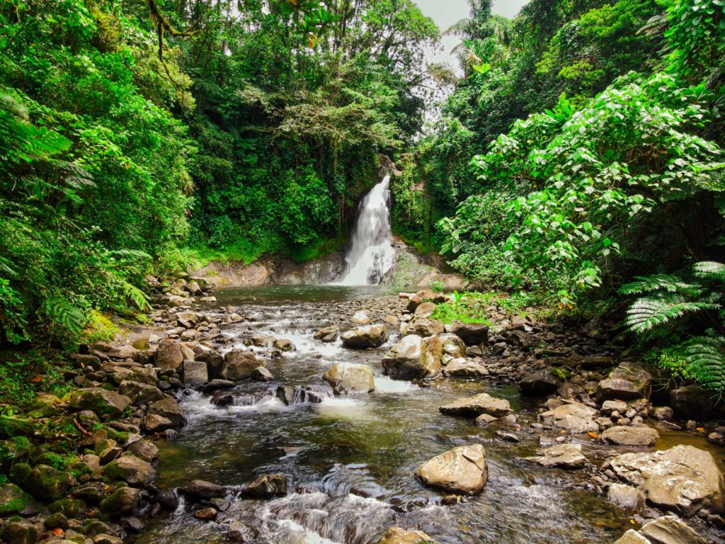
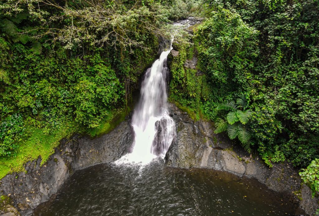
Paddling Around Central Madolenihmw
![]()
![]()
![]()
![]()
![]()
![]()
![]()
![]()
![]()
![]()
![]()
Dauen Sapwalap / Senipehn Mangrove Reserve
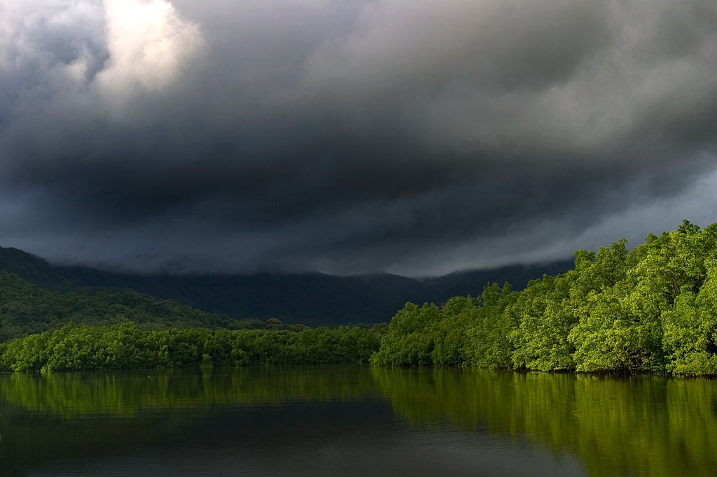
Dauen Sapwalap is the largest drainage in Madolenihmw, a wide, meandering channel that cuts through the mangrove forests from Kitamw and eventually empties into Madolenihmw Bay. Although the Lehdau River (Pillapen Lehdau) is probably the largest contributor to this major estuary, the two are not synonymous; the channel is also fed by three other watercourses, including the Kitamw Stream (Pilen Kitamw), Pwadapwad Stream (Pilen Pwadapwad), and River of Sekere Riau (Pillapen Sekere Riau). According to legend, a powerful demi-god named Lapongo — the same character involved in the story of Takaiuh peak — dug out the channel with his penis. The matriarch of the Lasialap Clan — a great eel responsible for the creation of Lipwentiak in Kitti and whose tail formed the great mountain in Nett, Pohnlehr — was also said to have dwelt in this channel for many years, terrorizing the local inhabitants.
During the 1889-1890 wars between the Spanish and Pohnpeians, which began in Ohwa and concluded in Kitamw, two contingents of Spanish troops were dispatched at the mouth of Dauen Sapwalap and attempted to move up both banks of the Pillapen Lehdau (Lehdau River) to reach a small half-finished fort built on a low hill by the Pohnpeian fighters. The first group of soldiers got terribly lost in the tangled forests and happened upon the fort only by mere chance. The second group was forced off-route by a seemingly supernatural flood and also ended up lost, camping overnight at Elieliwi before joining the fray. The assault cost the Spanish 21 men, and in the end the Pohnpeians merely withdrew and yielded a position that had meant little to them from the beginning.
In the last decade, the estuary became part of the Senipehn Mangrove Forest Reserve and afforded some environmental protections; tree-cutting, fishing, and gathering of other natural resources in the area is prohibited in most circumstances. Paddlers can explore the 2.6 km (1.62 mi) primary channel and its side passages by launching near the Lehdau River bridge, at the end of the road near Tahio, at the Madolenihmw “Ice Dock”, or at the MERIP boathouse.
- Entering the mangrove reserve requires a permit. Visit our MPA page for details.

Takaiuh Peak
While Sokehs Rock is the stand-out natural feature in the north, in Madolenihmw that title certainly goes to Takaiuh (“standing rock”), a majestic conical hill-island on the north side of the bay. Westerners called this feature “Sugarloaf” after the molded cones of sugar that were popular in Western Europe as early as 1470, but the local name and its story are much more interesting (see Madolenihmw Bay Area page for more).
Paddlers can get right up close to the iconic hill for a view from the water that is better than from anywhere on land. There’s also good fun to be had noodling around in the mangrove forests on the eastern shore (at high tide). A sweet spot to stop for a picnic lunch is the top of an exposed rocky rise 0.36 km (0.22 mi) northwest of the peak (no mangroves skirt this bit of the shore).
Pahn Dieinuh
Pahn Dieinuh, the southern point of the Dolopwail peninsula, is significant historically for the 1836 conflict that began there between the visiting British whaleship Falcon and two rival Pohnpeian chiefs — Luhk en Kesik ( the Nahnmwarki) and the Wasai, the first and second ranking men in the royal line, respectively. Things got ugly when the Nahnmwarki made a move to seize the ship and its cargo. When the ship attempted to flee, it ran up on the reef. The cargo was transferred to Nahpali Island and then stolen a month later by the Nahnmwarki‘s brother, Nahnawa. A battle ensued on Nahpali between Nahnawa‘s party and the whalers, ending in the deaths of the ship’s captain and three other sailors. The Wasai, who had been challenging the Nahnmwarki‘s authority for some time, seized this opportunity to rid the land of his enemy by joining the crews of other whaleships in hunting down both Nahnawa and the Nahnmwarki. Fighting continued for several days until the Nahnmwarki was shot and Nahnawa captured and hanged from the yardarm of the whaleship Lambton. Both bodies were buried at Pahn Dieinuh, and the Wasai assumed the position of the Nahnmwarki. There isn’t much of anything to see at Pahn Dieinuh now, but it’s a good spot for a break mid-route. The closest launch points are MERIP boathouse, the “Ice Dock”, and the Metipw launch.
Mwudokolos Island
In addition to the seven islands (Nahpali, Dekemwahu, Na, Dehketik, Nahkapw, Nahnningi, and Mall) found around Temwen, there are three small islands to the north that shouldn’t be missed. The first of these — Mwudokolos — is found a half-kilometer (0.33 mi) northeast of Metipw and easily accessed from the coral-dredged causeway/dock found there (ask at the nearest house for permission to launch). Archaeologist Arthur Saxe believed that the island was tied to Nan Madol in some way and that it might even be a man-made island, but Japanese archaeologists working on the island in recent years have found no hard evidence to support that idea. They did discover prehistoric stone structures and a house platform that dates to the Nahnmwarki Period of Nan Madol (post-1700). Glass beads, sherds, and clay pipes were also found, suggesting that Mwudokolos was occupied by foreign traders in the late 1800s. The island is privately owned, but unoccupied.
- To obtain permission for day visits or overnight stays, call Sesuko Hadley at +691.320.2540.
Dahu Reirei Island
From Mwudokolos, paddlers can continue 1.8 km (1.13 mi) further north through the easternmost of two dredged reef channels to reach Dahu Reirei (“long channel”), a narrow, man-made islet with huts for picnickers and campers and lots of pleasant swimming and snorkeling. When we say this island is narrow, we mean narrow (10 meters wide). Unless you like being crammed together elbow-to-elbow, avoid the place on weekends and holidays. It’s also not a place to be on intensely hot days (there are no trees large enough to provide shade) or during bad weather (the island is hardly a meter above sea level at high tide). On partly-cloudy weekdays, however, it can be heavenly. The surrounding water is generally crystal-clear and the reefs, which consist mainly of varieties of staghorn coral, are surprisingly healthy and relatively well-populated with reef fish. Small thatched huts along the length of the strip can be rented for the day or overnight.
- To make reservations for day visits or overnight stays and to arrange boat transport, call Joseph Helgenberger at +691.320.2229.
Lepin Dau (“Channel Island”)
The final island covered in this sector (it’s just off the edge of the Central Madolenihmw map, but appears on the U & Northern Madolenihmw map) is claimed by the same family as Dahu Reirei and has no official name, but as it lies adjacent to the primary channel every boat in the area uses to go from Areu and Ohwa to Madolenihmw Bay, it’s known as Lepin Dau or “Channel Island.” This island is larger and higher than Dahu Reirei and has some welcoming tree-cover (mostly pandanus). The channel on the west side is a nice spot to snorkel at slack tide, but at other times, the current can be so strong that snorkelers and swimmers run a strong risk of being swept away. A better spot for snorkeling is in the blue holes around the southeast side — well out of the path of the current. Here you can find beautiful coral grottoes, huge schools of needlefish, barracuda, cuttlefish, trumpetfish, angelfish, and parrotfish, an odd seasnake (the latter are venomous, but so passive that they pose little danger to snorkelers), and from time to time even eagle rays and small green turtles. It’s a fantastic picnic destination for paddlers.
- You don’t really need to get permission to make day visits to “Channel Island,” but overnighters should call Joseph Helgenberger at +691.320.2229.
Nanwap Marine Protected Area
The reefs on the north side of Kepidauen Deleur make up the Nanwap Marine Protected Area (MPA), a marine reserve with excellent snorkeling and diving. The best place to snorkel is about 1.3 km east of Metipw in a protected reef hole, but watch for strong currents.
- Visit the Madolenihmw Bay Area page for a detailed description of this location.
- Entering the MPA requires a permit. Visit our MPA page for details.
Paddling Distances Around Central Madolenihmw
| Starting | Ending | Distance (km) | Distance (mi) | |
| “Ice Dock” | —- | Tahio* | 3.12 km | 1.94 mi |
| “Ice Dock” | —- | Sekeren Senipehn | 2.5 km | 1.6 mi |
| Sekeren Senipehn | —- | Dauen Wetiak | 1.7 km | 1.0 mi |
| Dauen Wetiak | —- | Dauen Sapwalap | 1.3 km | 0.8 mi |
| Dauen Sapwalap | —- | Pilen Kitamw (Kitamw Stream) Bridge | 2.6 km | 1.6 mi |
| “Ice Dock” | —- | Takaiuh Shore* | 2.45 km | 1.5 mi |
| “Ice Dock” | —- | Pahn Dieinuh* | 2.6 km | 1.62 mi |
| Takaiuh Shore* | —- | Diadi | 3.44 km | 2.1 mi |
| Japanese Wharf, Temwen Is. | —- | Diadi | 0.99 km | 0.61 mi |
| MERIP* | —- | Pahn Dieinuh | 2.48 km | 1.54 mi |
| MERIP* | —- | Salong Point, Temwen Is. | 2.2 km | 1.4 mi |
| Salong Point, Temwen Is. | —- | Japanese Wharf, Temwen Is. | 1.0 km | 0.64 mi |
| Japanese Wharf, Temwen Is. | —- | Nahpali Island | 2.63 km | 1.63 mi |
| Nahpali Island | —- | Metipw Launch | 2.59 km | 1.61 mi |
| Diadi | —- | Metipw Launch | 2.8 km | 1.75 mi |
| Kepidauen Deleur | —- | Nanwap Marine Protected Area (MPA) | 1.24 km | 0.77 mi |
| Metipw Launch | —- | Mwudokolos Is. Circumnavigation | 1.4 km | 0.9 mi |
| Metipw Launch | —- | Dahu Reirei Is. | 1.86 km | 1.2 mi |
| Dahu Reirei Is. | —- | “Channel Island” (see U Municipality & Northern Madolenihmw guide) | 1.53 km | 0.95 mi |
| Metipw Launch | —- | Pilen Semwei | 2.61 km | 1.62 mi |
*Silted-in reef. This segment may be difficult or impossible to traverse at low tide.
Paddling in Nett, U & Northern Madolenihmw
Dausokele Estuary
As paddling goes in the Nett region, Dausokele estuary (“channel of the dwarves”) is the crown jewel, a long, gorgeous inlet that lies between Kolonia and the leaf-shaped Nett Peninsula and serves as the mouth of a number of high-volume rivers and streams. The scenery is stunning, especially on days where rain threatens, with high, sheer cliffs to the east, the heights of Dolen Nett in the north, and the pyramid-like peak of Dolen Eirike in the south. Depending on where you begin, you can go as far as 4.5 km (2.8 miles) inland before having to turn around. Most of the way, mangrove forests skirt the coast, so there’s nowhere to land and get out. The final 0.7 km (0.4 mi) follows meandering, narrow natural channels through the swamp forests, where you’re liable to meet locals and traditional outrigger canoes and young kids having a swim. The route tends to be well-protected from both currents and wind, so it’s a nice, leisurely paddle, allowing plenty of time to soak up the scenery. There are multiple places to launch on the Airport Causeway as well as the “Ice Dock” near the Kolonia Public Market building, and next to the PAMI building.
Nett Point
Another great paddling destination is Nett Point, Kolonia’s best swimming spot and the closest thing to a beach Pohnpei Island has to offer. Lidakika Launch point on the Airport Causeway is the most practical place to begin.
- Visit the Nett Point page for detailed information about this location.
Dolen Nett Peninsula Circumnavigation
If you want to try something a little longer and more challenging, you can continue past Nett Point, explore the east coast of the peninsula (which includes one of the locations where the mythical builders of Nan Madol were said to have briefly settled), and then cross the beautiful little bay to the quaint picnic and swimming area at Awak Pah Marine Park. Note that strong winds can be a problem along the eastern coastal section. If you’re plan is a there-and-back-again, you’re looking at around 17 km (10.6 mi) round-trip.
Lenger & Sapwtik Islands
Two of the most interesting islands on Pohnpei are found directly north of Kolonia and can be reached quite easily via paddle-power. Both islands offer a wealth of Japanese fortifications from WWII and earlier, as well as other historical sites, swimming, and snorkeling.
- The islands are covered in detail on the Lenger Island & Sapwtik paddling page.
Parem Island
The largest island in the northern lagoon is Parem, which is large enough to have its own elementary school. Like nearby Lenger and Sapwtik, the Japanese fortified the island prior to WWII. In fact, the coastal gun on Sokehs Mountain may have once been positioned at the top of Dolen Parem before being moved to its present location.
With the exception of a portion of the eastern coast, Parem is completely surrounded by mangrove forests — some of them quite extensive. There are two good channels to explore on the west side where the mangroves are at their widest — one 0.7 km (0.4 mi) long and the other 0.4 km (0.25 mi). Both reach all the way to solid ground at high tide and are beautiful places to scope out the local birds. You can also do a complete circumnavigation of the island, which is 7.9 km (4.9 mi) in total. On the east coast there’s a long stone wharf jutting out from the shore, suitable for a little break, a snack and a dip.
Paddling Distances Around Nett, U & Northern Madolenihmw
| Starting | Ending | Distance (km) | Distance (mi) | |
| Lidakika Launch Point | —- | Causeway Tunnel | 1.5 km | 0.9 mi |
| Causeway Tunnel | —- | Dausokele Bridge | 2.4 km | 1.5 mi |
| Dausokele Bridge | —- | Inlet Terminus | 2.24 km | 1.4 mi |
| Causeway Tunnel | —- | Nett Point | 2.3 km | 1.4 mi |
| Nett Point, Nett | —- | Awak Pah Marine Park (along the coast) | 4.75 km | 3 mi |
| Nett Point, Nett | —- | Awak Pah Marine Park (as the crow flies) | 2.8 km | 1.7 mi |
| Lidakika Launch Point | —- | Awak Pah Marine Park | 17 km | 10.6 mi |
| Misko Beach, Dekehtik Island | —- | Barbosa’s Wharf, Lenger | 4.52 km | 2.8 mi |
| Ice Dock, Kolonia Town | —- | Barbosa’s Wharf, Lenger | 3.53 km | 2.2 mi |
| Nett Point, Nett | —- | Barbosa’s Wharf, Lenger | 1.97 km | 1.22 mi |
| Nett Point, Nett | —- | South Point, Parem | 2.5 km | 1.6 mi |
| South Point, Parem | —- | South Point, Parem (Loop) | 7.9 km | 4.9 mi |
*Silted-in reef. This segment may be difficult or impossible to traverse at low tide.
Nihpit Plateau Savannahs
Mallen Nihpit & Mallen Pitetik
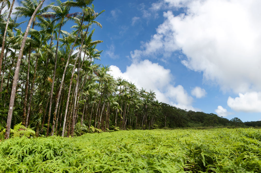
On the large upland plateau of Nihpit in the mountains above Mwoakot are two expansive savannahs or fern meadows. Upland savannahs of this sort usually exist because the bedrock is shallow, but they are also periodically burned by residents, inhibiting the growth of larger shrubs and trees. Hunters say that the Philippine sambar deer that live in Pohnpei’s interior — probably introduced by the Germans from the Mariana Islands — are attracted to the ash. One hunting tactic is to lie hidden at such sites and wait for the deer to creep from the forest in the early dawn (photographers might use the same method). Both of the savannahs soak up rain and feed tributaries of the Ne Stream (Pilen Ne). The northernmost and the larger of the two meadows — about a half kilometer in length — is usually referred to as Mallen Nihpit. The other savannah is Mallen Pitetik. Birders and photographers will find this a wonderful place to camp and observe fauna rarely disturbed by human activity. The palm forests around the edge provide plenty of shade, and drinking water can be filtered at the stream about 100 meters away.
The hike begins on the right side of the unpaved secondary road opposite the track leading to the Wene Latter-Day Saints Church — 0.92 km (0.57 mi) past the Nanwou Stream bridge — and leads up to a farmstead. Your guide will stop at a cluster of residential buildings to ask permission to cross the family’s land before leading you on. About 160 m beyond this is the first of two major stream crossings — one on a log and the other across a covered wooden bridge. After the second bridge, the trail climbs steadily for 1.47 km (0.9 mi) at a 25% slope average into forests full of huge Terminalia carolinensis (kehma) — found only on Pohnpei and Kosrae — and Atuna racemosa, a tall, straight hardwood locally called ais. The latter have many uses including treatment of diarrhea and dysentery. The white nut inside the ais fruit is ground and mixed with red soil to produce paint for canoes, while the extremely hard and termite-resistant lumber is a favored building material. If you hike in the evening, keep an eye out for eerie salengen eni (Filoboletus manipularis), bioluminescent mushrooms said to grow in areas where ghosts reside (the name means “ghost’s ear”). The tiny fungus often grows from rotten logs and looks like clusters of eyes in the dark. Interestingly, some Pohnpeian parents are known to control misbehaving youngers by threatening to send them to places where the mushrooms thrive. At this point, hikers have reached the edge of the plateau and the remaining 1.08 km (0.67 mi) is relatively flat with a 6% slope average. There are four small stream crossings along the hike. The first three come down from Mallen Pitetik and converge, forming a high waterfall as they drop off the plateau; follow the second stream up for 0.34 km (0.2 mi) to reach that savannah. The last stream originates in Mallen Nihpit and makes a good place to filter/purify water when camping in the area.
- Plan for 8 hours for this hike.
- Please visit the Local Guides & Tour Operators page for a list of experienced guides available for hikes to Nihpit. Offer $50.00 for a group of five or less.
Woaloahmw Waterfall (Rohi)
![]()
![]()
![]()
![]()
Rohi, the first district in Kitti after passing over the border from Madolenihmw, is host to an obscure, but beautiful, waterfall that few people — other than those who live practically at its feet and some Peace Corps volunteers stationed in the neighborhood — seem to know about. The high, sometimes wispy, falls plummets over a sheer wall hung with ferns and other climbing plants and is reminiscent of Sahwartik in Salapwuk, but with a much smaller and shallower pool and less volume overall. It’s unclear whether it has an official name; local residents mostly call it the “Rohi Waterfall” after the district within which it lies or “Nan Rohi Waterfall”, after the name of the river, or “Woaloahmw Waterfall”.
To reach it, it’s best to park near the turn-off from the Circle Island Road, walk up the steep gravel secondary road, and continue to the houses at the end (bear left at the one major branch). Along the way is a stunning stand of huge hardwoods that are well-worth a good look. Once you reach the houses, you’ll want to ask permission to proceed, as the footpath crosses through several families’ front yards. The residents in the area, however, are welcoming and will likely be happy to show you to the falls or at the very least point you in the right direction. Once the path reaches the watercourse, the waterfall is evident just a bit upstream and one has merely to scramble along the rocky bank to the pool. The water is very clean and cool, and the spot is excellent for a short swim.
No fees are charged for this hike.
- Plan for 1 hour round-trip with some swimming time at the falls.

Nanpohnmweli Waterfall
")
![]()
![]()
![]()
Though you can reach the top of Nanpohnmweli from Mand, the best way to access this falls (also known as “Kerenis” Waterfall) is from the Circle Island Road in Sapwehrek Kousapw. The walk begins at Benford Etse’s residence immediately south of the bridge and the sign for the Senipehn River Reserve and takes less than 10 minutes each way, following a well-trodden path that the family uses for planting sakau.
It’s hard not to be impressed by the place, even if you’ve already seen many of Pohnpei’s waterfalls. Like Kepirohi, the water tumbles over a gently sloping basalt wall rather than falling straight down over a cliff, but this falls is narrower.
[warning]Unfortunately, testing in April 2013 indicated that this site had 2.5 times more E. coli than is considered safe for swimming, so you’ll want to stay out of the water.[/warning]
The Etse family doesn’t charge an access fee to visit the falls, but since you’ll need someone to show you the way through their property, offer $5.00.
- Plan for 45 minutes round-trip with some time to admire the view of the falls.
Mand Area Attractions
![]()
![]()
![]()
![]()
![]()
Mand is a little community of Pingelapese people who were given a parcel of land by the Nahnmwarki of Madolenihmw in Pohnpei’s modern past. You can’t call it a town, but it feels more connected than many of the island’s Pohnpeian communities. In addition to the Pingelapese who live in Mand Proper, there’s a small village to the north inhabited by Kapingamarangi islanders, who settled in the area very recently (Kapingamarangi is a distant atoll that is culturally and linguistically Polynesian but politically a part of Pohnpei State). The center of Mand consists of the elementary school and church. Next to the church is a monument which lists the names of the first settlers from Pingelap Atoll — the founding members of the community.
Kokomaru Waterfall
Most local people outside of Mand have never heard of Kokomaru, which is strange, because it is a gorgeous spot and worth visiting. The route to the waterfall, which lies just downstream from the Mand community, begins at the end of an unpaved road next to the Latter-Day Saints (LDS) Church, passes through a plot of private land, and then cuts through the forest to the river. The trail tends to be overgrown, as the falls is rarely visited except by an odd kid or two from the community. Once at the riverbed, you can get a good look at the waterfall, which is similar visually to Liduduhniap. Some of the kids in the area will tell you that the rock behind the falls looks like a heart from certain angles (we didn’t see it). The cliff on the south side of the waterfall pool is the nesting site for a huge colony of Caroline Islands swiftlets which seem to fill the air when they leave their nests.
[warning]Despite Kokomaru’s charms, you can’t swim here — riverside pig pens in Mand have severely contaminated the stream. Testing in April 2013 indicated that the water below Piladad had five times more E. coli than is considered safe for swimming. Don’t be fooled by the clarity of the stream; this is sadly in the top ten most polluted watercourses on Pohnpei Island. Even the Mand kids don’t swim there.[/warning]
- Plan for 45 minutes round-trip for this excursion.
Piladad Pool
There is only one place you can safely swim in the Mand area and that’s at a sweet little pond known as Piladad, which lies up-stream from the last inhabited house and pigpen. The pool, which was once a gauging station for the watershed (the gauge apparatus is still there), is large and pristine with enough depth in the middle for the fun rope swing that dangles from an overhanging tree. There are also two small waterfalls. Piladad is a great place to go on hot days; the spot is close to the feet of the mountains and the water tends to be quite chilly. This also means there’s some potential for flash floods, so it would be wise to avoid the spot when rain clouds lie over the mountains. A narrow, but well-used, 0.4 km footpath to the pool begins on the south bank of the river next to Mand Elementary School. At the one branch in the path, bear toward the river.
Almost any kid you see in the area can guide you to either location. Offer $10 for a group of five or less.
- The hike takes about 10 minutes each way.
Nanpohnmweli (“Kerenis”) Waterfall
This very tall waterfall on the Sapwehrek stream can be reached by following the unpaved road 1.24 km (0.77 mi) north and east from Mand through a tidy Kapingamarangi settlement to the next stream over. The problem with visiting the falls from this access point, however, is that you end up at the top, where you can’t really see much. The rocks are treacherously slippery and there’s a long — certainly fatal — fall for anyone who makes a mistake. A local girl was killed when she fell from this spot a few years back. The nickname of the waterfall is derived from the Kapingamarangi pronunciation of the English word “Greenwich”, which is what sailors called Kapingamarangi Atoll during the whaling period. To visit this waterfall from the bottom, visit the Nanpohnmweli Waterfall page.
- This walk takes 15-20 minutes each way.