
Liduduhniap Waterfall, Nanipil & Nan Madap Attractions
![]()
![]()
![]()
![]()
![]()
![]()
![]()
Liduduhniap Waterfalls
The easiest waterfalls to visit on Pohnpei (no hiking required) are the tiered “horse-tail” falls, Liduhduhniap, just a few kilometers from Kolonia. When the Greater Nett Eco-Adventure Guide was published in 2015, we wrote of Liduduhniap:
“Some might consider accessibility to be a red flag and assume that a location so close to town would be completely spoiled by a constant flow of visitors and thoughtless development. That’s not the case here.”
Unfortunately, things have changed recently (2017). Under the direction of Pohnpei’s new tourism department, the landowners at Liduduhniap have chosen to severely undermine the natural integrity of the site by replacing the dirt path to the lower falls with an unsightly series of concrete steps and a concrete hut near the edge of the pool. Toilets have also been built on the site. For those of us who knew the place before this “development”, it will never be quite the same again, but Liduduhniap is still a beautiful spot — not just the two waterfalls themselves, but the greater area, which is lush, rugged, and often partially enshrouded in thick mists that drift down from the steep mountains. The population around the site is relatively sparse, and it is hoped that most of the land will remain as it has for decades — green and wild.
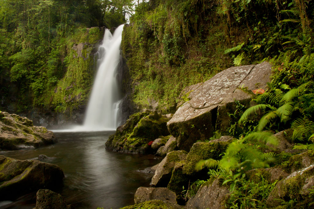
The Liduduhniap Waterfalls lie on a portion of the Nanipil River (Pillapen Nanipil) located right at the feet of the mountains and fed by a great deal of rain (the primary dam and reservoir that supplies the town with water is just a bit upstream). The upper falls cascades 4 meters (13 ft) into a deep basalt plunge pool with a jaw-dropping elevated view of the river valley and the slopes of the mountains. From there it spills over the lip and plummets another 8 meters or so (26 ft) into a larger, but shallower pool. Swimming is excellent at both pools, though the first is more difficult to get in and out of. Most people simply opt to take a flying leap off the rocks, but you can also carefully cross the river above the falls and climb down to the pool from the far side without too much trouble (go barefoot or wear five-fingers to avoid losing your flip-flops in the swampy sections). The water is crystal clear — except immediately after heavy rains — and always on the chilly side, making it a great escape for oppressively hot and humid Pohnpei days. The deep, narrow valley funnels air along so that there’s always a bit of a breeze, too, which keeps the ferns waving hypnotically and the temps down. No one is quite sure how deep the upper pool is, but it’s deep — deeper than you’ll ever sink after a jump. However, one must still take care to scan the water before leaping; flash floods sometimes wash tree trunks and other debris down from the mountains and these can become wedged in the pool below the surface. Depending on how high the river is, you may be able to swim up and get behind the falls, where there’s a small depression in the rock. There’s also a large cavern on the eastern side of the pool. The lower pool is too shallow for jumping.
The well-manicured and landscaped gravel trail to the site begins left of a large nahs (community hut) near the unpaved road and opposite the landowners’ house, meandering past blossoming hibiscus shrubs, plumeria trees, and ginger until it reaches a couple of ramshackle huts above the river. These make nice spots for a picnic lunch, while in the evenings the family uses them for pounding and drinking Pohnpei’s dizzying ceremonial drink, sakau (kava). Turn right by the huts and scramble down to the river to visit the upper falls. Note the mortar holes on the north side of the pool rim, where sakau was pounded in ancient times. To reach the lower pool and waterfall, continue along the main trail and down a series of concrete steps. The family charges an access fee of $1.00 per person to visit the falls. Occasionally they may ask you for $5.00 if it looks like you plan to take a lot of photos of the site.
[warning]Be advised that there have been many injuries and several fatalities at Liduduhniap! The spot is extremely prone to flash floods. In 1999, two Pohnpeians were swept away by a flash flood and carried over both falls to their deaths. In 2002, three visiting Palauan athletes were also killed by a flash flood; there’s a monument to them next to the trailhead. Danger from slips and falls is another issue. In 2012, an American educational volunteer fell to her death from the upper falls, which prompted the landowners to install a dodgy rope ladder on one side of the upper pool. Read the Safety Considerations in the right column and BE CAREFUL.[/warning]
- Plan for 30 min – 2 hours to enjoy the waterfalls.
Upper Nanipil Bird Walk
If you continue up the road from Liduduhniap, you’ll soon pass the dam and reservoir on the left. Just beyond this, also on the left, a footpath leads into the forest and runs through the woods above the stream for 1.1 km (0.68 mi). Among birders, this scenic walk is second only to Sokehs Mountain in terms of the variety and prevalence of species that can be seen. It’s easy to get to and doesn’t require any huffing and puffing, and the forests are rich and unspoiled and full of birds. There are no houses along the trail, which means that traffic and noise are at a minimum. You can see many species on the walk, but highlights include the Pohnpei Cicadabird (Coracina insperata), Pohnpei Fantail (Rhipidura kubaryi), Pohnpei Flycatcher (Myiagra pluto), and Crimson-Crowned Fruit Dove (Ptilinopus porphyraceus). We suggest you hire a local birding guide and bring a pair of binoculars. Stick to the path to avoid damaging this pristine watershed.
- Plan for 2-3 hours for this walk.
- Visit our Birding page to learn how to find birding guides.
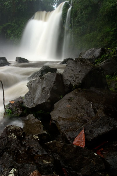
Sengnaip Waterfall
This little-known two-tiered waterfall is located about 400 m (0.25 mi) south of the Nanipil Bird Walk described above. If you cut off the path and continue down the slope for about 170 m (186 yd), you’ll hit the main stream, which you can follow up for another 144 m (157 yd). At this point, you reach a large basalt pool that narrows on the far side and disappears into a rocky slot. You can get a great view and wonderful pictures of the falls from the rocks on the east side of the pool, but there’s no easy way to go further without swimming. If you do the latter, you’ll end up in a small plunge pool enclosed on three sides by high rock walls. There’s a cave just above the water level on the east side. The spot is unbelievably peaceful and has been seen by very few people. Treat it with utmost respect.
[warning]Like Liduduhniap downstream, this location has extreme flash flood potential. Read the Safety Considerations in the right column.[/warning]
- Plan for 2-3 hours for this excursion.
- Visit our Guides & Tour Operators page for a list of guides who can be hired for this hike.
Likei & Pahn Pwet Waterfalls
If you hire a knowledgeable guide and continue hiking south at the conclusion of the Nanipil Bird Walk (where the trail crosses a stream on a large log), you’ll soon strike the main river again. The route stays with the watercourse for 1.5 km (0.93 mi) with very gentle elevation gain (4% slope avg). At the end of this segment, the river is joined by another stream coming from the southeast. Following either course for about a third of a kilometer will lead you to a waterfall. The western route continues 0.37 km (0.23 mi) up a slope, where the hike steepens to about a 25% slope average before coming to Likei Waterfall. The eastern course leads 0.23 km (0.14 mi) with a 18% slope average to Pahn Pwet Waterfall. The two waterfalls are quite dramatic and little-known both by visitors and by local people. This area, called Nan Madap, is actually disputed territory; both Sokehs and Kitti claim it, though the municipal boundaries as they are typically drawn seem to place the location within Sokehs.
- Plan for 5-7 hours for this hike.
- Visit our Guides & Tour Operators page for a list of guides who can be hired for this hike.
Nan Kiepw Waterfall
Also with a local guide, a third falls can be accessed from a completely different route, beginning just west of the community hut by the Liduduhniap trailhead. This hike climbs up the mountain slopes fairly steadily for 3 km (1.86 mi). The first two thirds of the distance is relatively easy with a slope average of about 12%, but then the slope steepens considerably to about 41%. Nan Kiepw Waterfall is high up at about 500 meters of elevation (it may be one of the highest falls on the island), just below the summit of Dolen Nanikep and off the east side of the trail. Sometimes you can see this falls from the lagoon after heavy rain.
Serious trekkers have the option of continuing past the waterfall, up to Dolen Kiepw (610 m), and on to Dolmweir (735 m), where a thatched shelter was built for hikers in 2013 (note that the roof of the hut was already deteriorating when we visited only six months or so after it was constructed). This is an admittedly tough hike with slopes ranging from 25% to 40% and very rough terrain. The shelter is 1.5 km (0.93 mi) beyond Nan Kiepw falls. From the shelter, trails run west to Pekenuht (705 m) and down into Pehleng or east to Nahnalaud (772 m).
- Plan for 5-7 hours for this hike.
- Visit our Guides & Tour Operators page for a list of guides who can be hired for this hike.
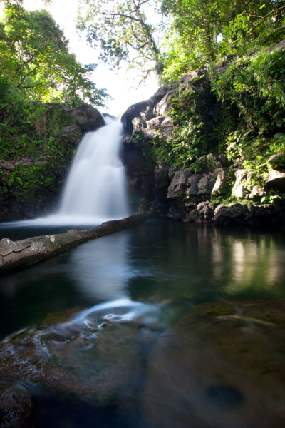
Nanipil River Swimming Holes
“Cable Bridge Hole”
This is by far the most popular swimming spot on the Nanipil River located 4 km (2.5 mi) from downtown Kolonia, where the watercourse turns sharply away from the Nanipil River Road and forms two deep, placid pools. There used to be a cable footbridge that crossed this portion of the stream, but now all that remains are a couple rusting cables strung high above the water. The water at the site is clean and quite cool — an excellent place to freshen up on a sweltering afternoon. Avoid the site, however, during or immediately after heavy rain, as the water gets muddy from all the sediment washing into the valley upstream. Cars can be parked on the opposite side of the road.
“The Swimming Pond”
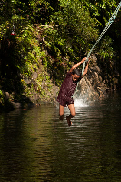
This is a favorite with young kids in the area, located 5.3 km (3.3 mi) from downtown Kolonia. A short walk from the Nanipil River Road leads to a long, deep pool with a steep slope on the far bank. Rope swings are often strung up on both sides of the pool, and there are some grassy spots to picnic and a tiny hut or two. The landowners, who live in a house on the side of the road opposite the trailhead, charge visitors $1.00 per person.
[warning]Flash floods are an issue at both sites, due to Nanipil Valley’s narrowness and the volume of rain that can fall in a short period of time in the steep mountains to the rear. Be wary.[/warning]
Dolen Nett / Pohnlehr
![]()
![]()
![]()
![]()
![]()
Dolen Nett (“hill of Nett”) is a steep-sided mountain running the length of the Nett Point peninsula. Leaf-shaped, this peninsula juts north into the lagoon east of Kolonia and is said, in myth, to have been formed by the corpse of the same monster eel that founded the Lasialap clan, created Lipwentiak, and lived in the Lehdau River for many years. When the creature finally died, her carcass became Dolen Nett.
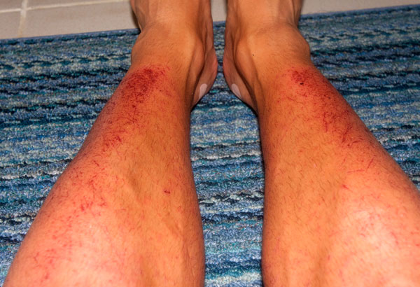
Like Sokehs Mountain, Dolen Nett is mostly flat on top, as if the peak was sliced off. From town, this plateau — known as Pohn Dolen Nett (“on the hill of Nett“) — looks like a manicured lawn, which has inspired the mistaken belief that it was once used as an airfield by the Japanese. In truth, there were only three Japanese airstrips on Pohnpei: one at Nanpohnmal, one in Palikir that never became fully operational, and the seaplane base on Lenger Island. There are hardwood forests around the edges of the plateau, but the central landscape of Pohn Dolen Nett is nearly treeless. Most of this open terrain consists of very resistant, and in many places, shoulder-high paddle grass and Dicranopteris ferns with swampy mires and sections of jagged basalt scattered throughout. It should be noted that the aforementioned ferns can be brutal on bare legs if you’re forcing your way through them for any length of time. That’s cat o’ nine tails brutal. Flay the flesh right off your shinbones brutal. We learned the hard way once, while mapping the location. One humble suggestion: hike in pants. Heat-stroke, too, can be an issue on the hill; with so little tree-cover, sunny days are blistering.
Japanese World War II Sites
As is true of all the high points around Pohnpei’s coasts, the Japanese fortified Dolen Nett in the late 1930s, anticipating an eventual attack by Allied forces (which came in the form of intense bombing raids rather than the expected surface-based assault). The most interesting war features are grouped together at the southern end near the true summit (an area called Pohnlehr) and include some steel drums, the barrel of a disassembled 75 mm canon lying in the woods, rock walls, two stone machine gun pillboxes, and a concrete and steel bunker that houses a second 75 mm gun in situ. To access the latter, which has excellent views of the bay between Nett and Awak, you have to move along a precipice, often partially or completely obscured by high grass. Let your guide go first to clear a path — unless you want to find yourself plummeting through empty space. The bunker itself can be entered, but it’s a bit of a grubby venture as the roof has partially collapsed and is now supported by the breech of the gun itself.
The other major site on the south side is a mobile radar array that sits on a low stone platform in the woods about 126 meters (138 yd) northwest of the gun bunker. The radar was mounted on a rotating turret in the center of a truck chassis (still intact) and the operator turned a wheel to position it. There are some large depressions in the surrounding forests that may be bomb craters, but none of the major features on the hill appear to have sustained direct damage from the bombing runs. More likely, these posts were simply abandoned, as they would not have been very effective against an aerial attack.
The woods pick up again on the north end of the mountain, and here, also, are some Japanese military features, including a large network of narrow defensive trenches, a few stone rifle pits, and machine gun emplacements.
Featured Routes
There are many ways to get to the top of Dolen Nett. We have covered four routes on the Greater Nett & Western U Eco-Adventure Map.
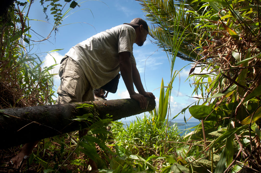
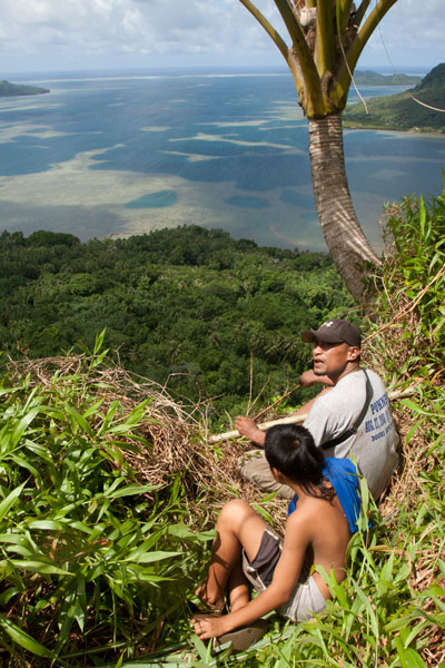
(1) The most practical route starts behind a house next to the road in Weipowe 1.2 km (0.75 mi) south of the Nett Point turn-off. Just ask at the houses on the inland side of the road for guides. The trail is well-maintained as far as the family’s private sakau (kava) and yam plantations on the slope. The steepest bit of the climb is at the beginning — 0.4 km / 0.26 mi, 33% slope avg. Near the top of the ridge, the trail passes the entrance to a long Japanese tunnel, well worth exploring — but bring a headlamp. From there, it continues up the forested slope and eventually comes to the open fern meadows, called nanmal (0.4 km / 0.3 mi, 22% slope avg).
(2) Another trail begins 0.6 km (0.37 mi) south of Trailhead 1 (look for a narrow concrete driveway next to a giant mango tree). This may have been the primary Japanese trail, but it is now difficult to follow above the point where farmers plant their sakau. About 0.56 km (0.35 mi) along (26% slope avg), the trail collides with an impassable basalt wall over which a thin waterfall can form after heavy rain. Here the trail turns south and continues about 0.29 km (0.18 mi) with a 17% slope avg, running parallel to the wall until it ends. Then it begins to climb again, briefly emerges in a small meadow, passes through some light forest, and emerges again at a rare grove of coconut palms (185 m / 202 yd).
(3) A third route begins at the edge of the road in Paliais 0.7 km (0.43 mi) north of the Dausokele Bridge. The route is about 0.7 km (0.43 mi) to the top with a 26% slope avg.
(4) The fourth route starts on the edge of the road 1 km (0.62 mi) south of the Nett Point turn-off. It climbs fairly straight 0.27 km (0.17 mi) with an 18% slope avg up to the ridge, which is much lower here. It then turns south and follows the ridge 0.43 km (0.27 mi) until it connects with Route 1 at the Japanese tunnel entrance.
Pohnpei Short-Eared Owl

The lonely meadows and forests on the mountaintop are prime habitat for Pohnpei’s shy short-eared owl, Asio flammeus. This species has been pushed up to the mountainsides by building projects — such as the State Hospital — which destroyed its native grasslands habitat. Late afternoon is a good time to look for the large bird rising from its hidden abode as it sweeps out to hunt (we spotted it on three out of five trips).
Camping
There are many fine places to camp on Dolen Nett. The nanmal is excellent on clear nights, where you can gaze both on the star field above and the twinkling lights of Kolonia below. If you want more cover or perhaps some trees to tie a tarp or hammock to, try the forests at the southern end. Bring plenty of water — none is found on the mountaintop — and take everything you brought with you when you leave. A good campsite is one that leaves no trace.
- Plan for 6-8 hours for this hike, if you want to see all the WWII features.
- Please visit the Local Guides & Tour Operators page for a list of experienced guides available for hikes to Dolen Nett. Offer $37-50.00 for a group of five or less.
The Story of the Eel of Pahdol
A long time ago, a couple from Wene came to live in a place called Iro. One day there was a great storm and the heavy rains resulted in a huge flood. Two women in the area went out to fish in the flood, and while they were fishing, a starling flew over and dropped a small stone. The women took the stone home and gave it to the couple from Wene. Later, at a place called Pahnkipar (“under the pandanus tree”), the stone broke apart and from it was hatched a tiny freshwater eel. The couple kept the eel as their pet and allowed it to live in a pool at Pahdol (“under the hill”) in Pahnais. When the eel grew up, however, it began to act in sinister ways. At night, the eel would escape from its pool and sneak into the house, where it would stare at the sleeping couple. The couple became uncomfortable and decided to kill and eat the eel, but the eel overheard their plan, came into the house, and attacked them. The couple fled into the forest and hid under a huge rock, where they believed they’d be safe. The eel discovered the hiding place and ambushed the couple, devouring them alive.
The eel then traveled into the Nanmeir Valley in Pohnpei’s interior and followed the Lehnmesi River source. There she met Kiroun Meir, a high-titled man, who brought her to live with him at his home. The two became lovers and the eel was impregnated. She was restless, however, and departed, continuing to follow the river. At Lipwentiak, the eel encountered a hunter named Kiroun Mand, killing and eating eels. Recoiling at this sight, she created a sharp turn in the river with the writhing of her body. Soon after, she gave birth to her first daughter, the matriarch of the Sounlipwentiak subclan. She had other children later who became the founders of the Lasiadohng (“eels of the dohng tree”) and Lasiakotop (“eels of the kotop palm”) subclans. After that, the eel went to live in Dauen Sapwalap, where she terrorized the local inhabitants, devouring so many that the land became mostly deserted. When the monster finally died, her body formed Dolen Nett.