
Nahnalaud — the Big Mountain
The Big Mountain
![]()
![]()
![]()
![]()
![]()
The highest mountain in the Federated States of Micronesia (FSM) is called Nahnalaud (which means “big mountain”) and is located almost in the exact middle of Pohnpei Island. Pohnpeians consider the mountain sacred and regard it with respect and reverence, though most people have never been there because of the long, difficult hike involved. Local deer hunters and upland sakau farmers are the most frequent visitors to the highland region. A limited number of foreigners also attempt the summit.
In reality, Nahnalaud is not a single mountain but rather the highest peak in Pohnpei’s contiguous central mountain system, which separates the five chiefdoms. The primary central ridge runs from west to east and then curves north toward U not far beyond Nahnalaud. Additionally, a secondary ridge runs south, leading to Pohnpei’s second highest peak, Ngihneni, and then turning sharply to the west. The two ridges fence in the long, narrow Nanmeir Valley — the most remote region on the island.
The exact elevation at the Nahnalaud summit is a matter of debate as the survey methods used in the 1970s to map the island have a significant margin of error. The official number is 772 meters (2,533 ft), but the peak may actually be higher than that — likely close to 780 m. Ngihneni (“spirit’s tooth”) is nearly the same elevation (a difference of a few meters), which has generated a long-running dispute about which is actually the highest point. Nett, Kitti, and Madolenihmw have also argued about which chiefdom can claim Nahnalaud, but according to the municipal boundary lines on the 1983 USGS map, each of these municipalities has a piece of the peak.
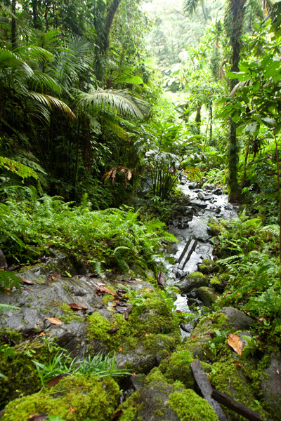
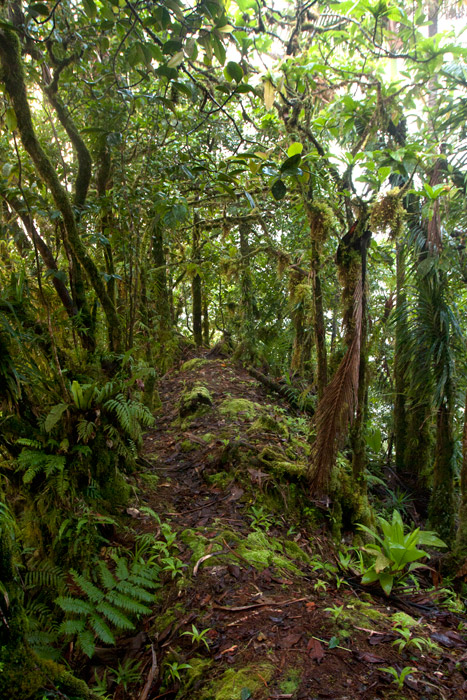
Hikers should be careful not to underestimate the mountain. Though the distance is not extreme, the terrain is. Experienced trekkers will find all of the approaches challenging merely because of the very rugged nature of Pohnpei’s interior mountains. The concept of switchbacks is little known on Pohnpei; trails are rough, rocky, and often go straight up the slope. Hikers who plan to tackle Nahnalaud should be prepared to walk along narrow ridges with steep slopes on either side; cross jumbles of broken, slippery rocks; ford medium-sized rivers (particularly on the Nett and Madolenihmw routes); walk in shallow, rocky riverbeds; ascend and descend slopes of 50 degrees or steeper; wade through muddy mires; cross slick logs; and push through high grass or ferns.
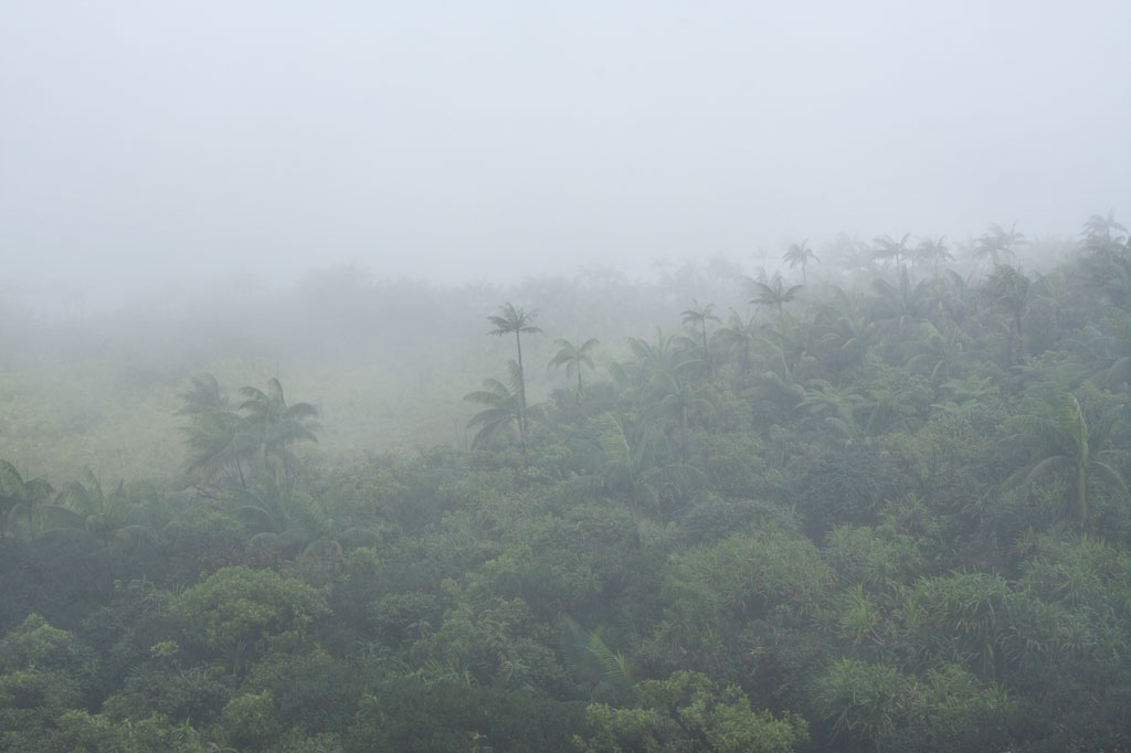
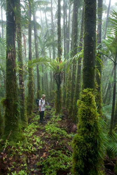
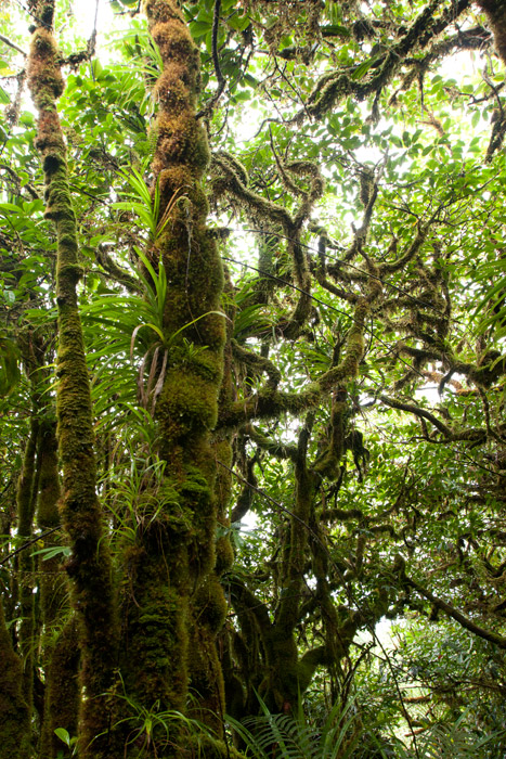
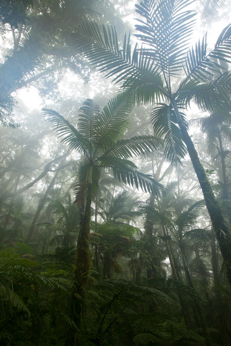
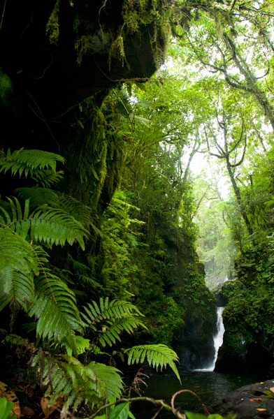
Despite the difficulty in getting to the top, the trip is well worth it. Those who have never visited a cloud forest before will be awed by the otherworldly beauty of the ridge, a perpetually dripping wonderland of stunted, hoary trees, air plants, and bryophytic growth. Virtually every surface is covered with a thick layer of spongy golden moss and the ground is composed of layer upon layer of damp, decayed matter. The area, which never dries out, gets at least 8.3 meters (325 in) of rain every year and is shrouded in thick fog much of the time, making clear views from the summit a rare occurrence.
[tabs]
[tab title=”Pehleng”]
Pehleng Approach (Western Kitti)
This well-defined trail up to the primary ridge and eventually to Nahnalaud was first promoted in 2013 by a local business calling itself Pohnpei Trailways. The idea was that this trail, starting in Pehleng, could be hiked by tourists without the assistance of a local guide. We strongly recommend that you do NOT do it that way. In fact, we think it’s a very a bad idea. Though at the time of writing (2014) the entire length of the trail was marked with pink flagging tied to tree branches, there is still plenty of potential for visitors to go astray. Furthermore, accidents or injuries without a local guide present could result in disaster. Remember that Pohnpei has no search and rescue service.
The true ascent begins after passing through a cluster of houses (ask permission) 0.95 km beyond the trailhead. After that, the trail is wide and true as it climbs steadily for 1.45 km (20% slope average) through the forest to the open fern meadow atop Dolen Salapwuk (510 m), where there are some good views in clear weather. The trail then re-enters the forest and begins to climb again for 4.6 km (13% slope average), narrowing as it comes up to the main ridge (696 m). Just before Shelter 1 (Dolmweir), there’s a 315 meter-long segment that is less than a meter wide with precipitous slopes on both sides; we’ve dubbed it the “Knife Edge.”
Shelter 1 is located at Dolmweir, where an appendage of the mountain thrusts north from the main ridge. There is no flowing water nearby. The privy is located 22 m to the north. After Shelter 1, the trail descends steeply by about 62 m on the south side of the ridge and skirts the base of a rocky cliff before climbing back to the ridge-top. From there it goes up and down for 2.94 km before reaching Mountain Shelter 2 roughly 5 minutes below the Nahnalaud summit.
- Plan for 5-7 hours from the trailhead to Shelter 1 and 3-4 hours from there to the summit.
[warning]NOTE: As of February 2014, the pandanus-thatch roofs of the two ridge shelters were in very bad shape, heavily deteriorated and leaky. Plan accordingly.[/warning]
The Origin of the Yap Banana
In the westward land of Sapani, a woman named Lienpwel (“woman of earth”) had two daughters, Lisoumokaiap and Lisoumokalang. The daughters decided to take a canoe and look for new land in the east and brought with them some “underworld yams”, banana shoots, and a stone called the Stone of Sahwar. The sisters eventually landed at a place in what is now Pwoaipwoai district (at that time the island was smaller and Pwoaipwoai lay near the coast). There they placed the stone and planted the yams. The stone was highly reflective, and when the sun would hit it, it would shine brightly (hence the name Sahwar, which means “shining” or “flashing”).
The younger of the two sisters, Lisoumokalang, eventually returned home to Sapani. On the way she visited the islands of Yap and propagated a new type of banana, which thrived and became the tallest of all banana varieties. Some time later, a Pohnpeian man who lived in a place called Loangen Kitti was looking west toward the sunset and he saw the tall banana plant in the distance. The ripe fruit were attracting many birds, so he found two starlings – one a common Micronesian starling (sioahk) and the other a Pohnpei mountain starling (sie) – and he took them up to a high mountain in Pehleng. The Micronesian starling was a lazy flier, but the mountain starling was clever and efficient. He sent both flying toward Yap. The Micronesian starling was distracted on the way and diverted from its course. Only the Pohnpei mountain starling reached its destination. It joined the other birds in eating the bananas, and while it did so, a seed became lodged in its feathers. Both birds eventually flew back to Pohnpei and landed at the peak of Pekenuht (which, appropriately, means “banana feces”). The seed carried by the mountain starling fell to the ground and propagated utin iap (the Yap banana).
[/tab]
[tab title=”Enipein Powe”]
Enipein Powe Approach (Kitti)
This route begins at the end of an unpaved road in Enipein Powe and climbs gradually on a well-defined footpath up an out-thrust from the southern ridge. At the top, the trail passes through a saddle between Nahnan Pwoaipwoai and Dolen Uhd, then descends slightly along the inside of the ridge slope, finally arriving at a massive overhanging rock known by local guides as “the cave.” The cave has nice views through the trees of the Nanmeir Valley at the Lehnmesi River source below. You can also see Nahnalaud to the northwest and make a guess at the direction of Ngihneni to the east. The cave is an excellent place to camp with a cushioned fern-lined floor (that stays dry in wet weather) and usually some dry firewood stowed by hunters in the vicinity (replace what you use).
From the cave, the trail continues along the inner slope below Ngihneni, crosses several small streams, and then climbs steeply (20% slope average) to the top of the main ridge. At this point it’s just a short walk west along the ridge path to the first open viewpoint near a USGS benchmark. The spot people typically consider to be the summit is 5-10 minutes further, and Shelter 2 is just below that.
- Plan for 6-8 hours from the trailhead to the cave and 90 minutes to 3 hours from there to the summit.
[/tab]
[tab title=”Salapwuk”]
Salapwuk Approach (Kitti)
There are many ways to Nahnalaud from Salapwuk but they all begin at the end of the road beyond Salapwuk Elementary School. The early part of the hike uses the same trail as the Six Waterfalls, but at the place where one would turn toward the river to encounter Falls #1 (Pahnairlap), one instead follows a trail going northeast. This trail stays north of the river, crossing above Iro, Nan Emp, and Lipwentiak waterfalls. The latter is the most spectacular, located where the river gets funneled into a narrow channel and makes a hairpin turn. According to legend, this feature of the river was created when the matriarch of the Great Eel Clan encountered an eel hunter and writhed violently in horror at the sight of the dead eels he was carrying. Small pools above the falls are home to Pohnpei’s endemic freshwater shrimp, which the guides might be willing to catch for dinner. After that, the trail only meets the river again twice, where it cuts through a wide loop in the watercourse. It then turns north and climbs 362 meters in elevation to the primary ridge, not far from the summit.
[/tab]
[tab title=”Nanipil”]
Nanipil Approach (Nett)
Though slightly shorter, the Nanipil approach to Nahnalaud is certainly challenging. It’s significantly steeper than the other routes (except Salapwuk) and the trail is not well-maintained once you reach the rear of the valley. The hike starts at the house next to the hydroelectric building at the end of Nanipil River Road. Immediately behind the house, hikers must cross a river and then shortly after that a small stream. An easy segment follows with a well-defined residential path leading to the last house in this part of the valley (1.39 km), where an old man lives alone.
Past the house, the route continues on a fairly well-defined path that crosses the river several times (these crossings can be tricky if there has been a lot of recent rain). In a few places, you have to walk in the river itself, which can be quite difficult given the slickness of the rocks. Finally, after 2.94 km (3% slope average), the trail begins to climb out of the valley on the east side of the river and follows a sub-ridge up from there (3.16 km with a 22% slope average).
The climb has several pitches with small, flat rest areas in between. The first stop has a conspicuous tree of gigantic proportions entwined with vines almost as massive. The second stop is frequently used as a camp site by hunters and is one of the few places on the mountain with mobile phone reception. The final segment leading to the primary ridge is steep and often muddy. In places it follows the natural pathway of small streamlets (keep an eye out for a small waterfall high up on the slope). Once reaching the main ridge (754 m elevation), it’s an easy 0.56 km walk east to Shelter 2, a typical nahs-style thatched hut that can sleep ten or so.
[warning]NOTE: As of February 2014, a large part of the roof of this shelter had rotted away, leaving the central part of the hut exposed to the elements.[/warning]
[/tab]
[tab title=”Nankepinmerepw”]
Nankepinmerepw Approach (Madolenihmw)
This route passes through the gorgeous valley of Nankepinmerepw, following the upper tributaries of the Nan Riohk Stream and eventually arriving north of Nahnalaud on an arm of the primary mountain system.
The hike begins at a rutted turn-off from the well-graded (but unpaved) road to Pahn Sile Waterfall, leads to a metal footbridge over the Senipehn River — the only bridge like it on the island — and connects with a path on the far side. From there, the trail meanders northwest not far from the Nan Riohk and more or less parallel to it.
The first kilometer or so cuts through cultivated lands. Then it begins to follow the water more closely as it passes into the wilder riverine forests. There are at least nine major stream crossings in this next segment, some of which may be difficult or impossible if there has been a lot of recent rain. Above the last major Nan Riohk tributary, where the name of the stream changes to Nankepinmerepw, hikers take to the stream bed itself, which is certainly the most challenging aspect of the route (13% slope average). The algae-slimed rocks are slick and dangerous and hikers may find that they have to go very slow and use both hands to avoid disastrous slips; it would be easy to snap an ankle or shatter a kneecap in this place. Despite the rough terrain, the scenery in this narrow valley, often fenced on both sides by high rocky walls, is terrific. At times, the trail passes along the tops of vertical prismatic basalt columns.
The first few points of interest are beautiful pools that will tempt any overheated hiker — and why resist? A bit further is a small waterfall near a prismatic basalt quarry site for Nan Madol. Abandoned prisms can be found lying in the stream bed in several places — the largest just below the falls. How exactly prisms were hauled down to the coast from this site is anyone’s guess. After a short, steep section (22% slope average), the valley terminates at a huge “horsetail” waterfall that the route crosses above (you can scramble down the eastern slope without too much difficulty for a better view from the side). The shallow pools above the falls are also an excellent place for a look at Pohnpei’s native crayfish.
Past the big waterfall, the stream narrows until it reaches a third waterfall — this one short and wide, falling over a straight lip (usually called a “block falls” or “sheet falls”) — and then diminishes to a trickle. From this point, the hike climbs west (29% slope average) and then south again as it follows the ridgeline (18% slope average) toward the Nahnalaud summit.
[/tab]
[/tabs]
How Long Will It Take?
Though it is possible to hike up and down Nahnalaud in one day, as we did during one of the many data-gathering excursions, we don’t recommend that you put yourself through that kind of torture. Hiking to Nahnalaud should be considered a 2-day affair with one night spent either at the cave, one of the mountain shelters, or somewhere else on the ridge. Inexperienced or out-of-shape hikers may need three days or more.
Hiring a Local Guide
All of the routes up to Nahnalaud require an experienced local guide.
You should offer your guide no less than $160 if there are five or less in your group and at least $220 if there are more than five (plus tips). If you do the math, you’ll see that this is quite reasonable. With five people, each hiker pays just $32 plus tips — a super bargain. If you can’t assemble a group, you’ll still only pay $80 per person with two hikers, which is less than you’d pay for two dives at virtually any SCUBA company in the world (and this is two days and one night). Obviously, if you plan to take a slower pace and do the hike over three or more days, you’ll need to pay your guide more.
Your guide is your lifeline; you will depend on him to keep you safe and on the right track throughout the duration of your hike. Guides provide other useful services as well, such as making campfires in damp weather. If you expect your guide to cook meals for the group or carry any gear for you, he should be paid extra. Agree on a price beforehand.
- Please visit the Local Guides & Tour Operators page for a list of experienced guides available for hikes to Nahnalaud.
Liduduhniap Waterfall, Nanipil & Nan Madap Attractions
![]()
![]()
![]()
![]()
![]()
![]()
![]()
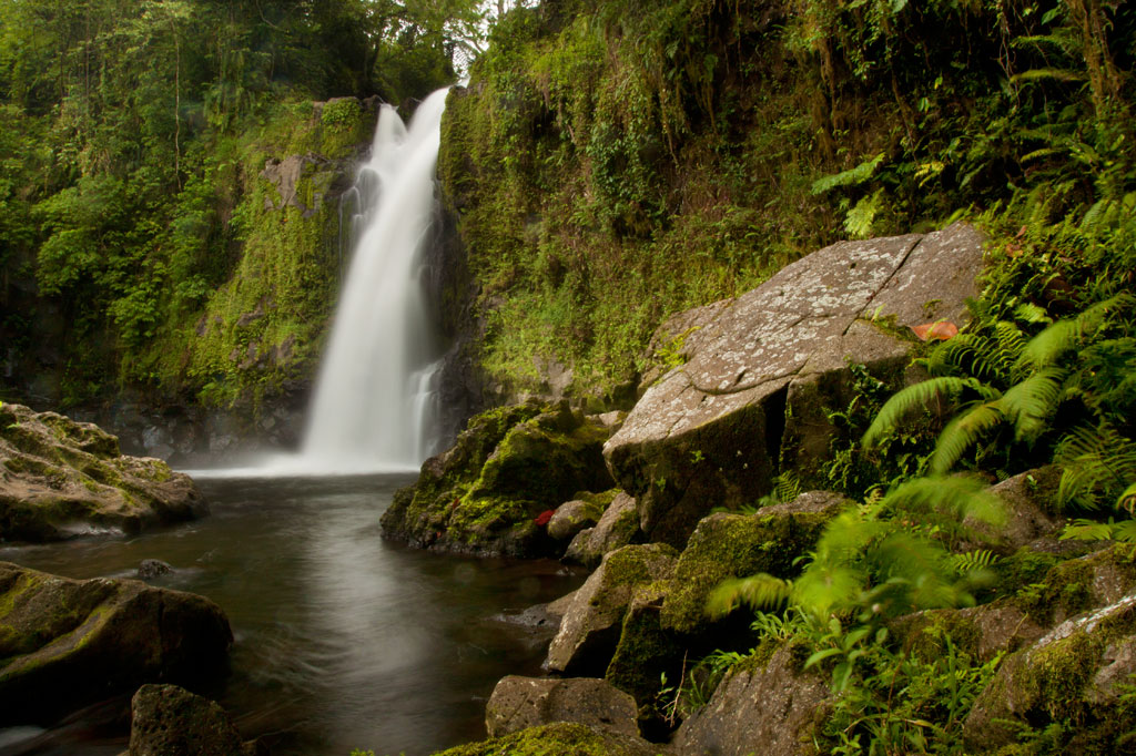
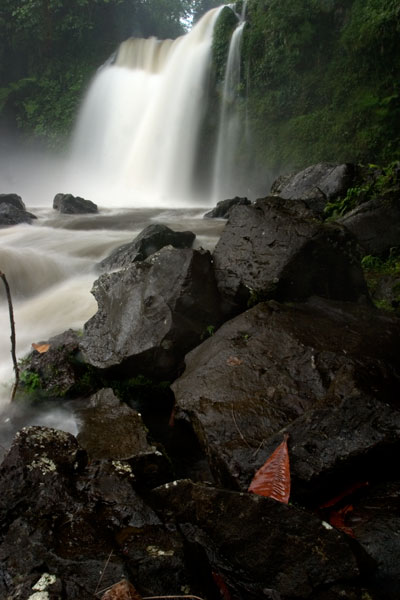
Liduduhniap Waterfalls
The easiest waterfalls to visit on Pohnpei (no hiking required) are the tiered “horse-tail” falls, Liduhduhniap, just a few kilometers from Kolonia. When the Greater Nett Eco-Adventure Guide was published in 2015, we wrote of Liduduhniap:
“Some might consider accessibility to be a red flag and assume that a location so close to town would be completely spoiled by a constant flow of visitors and thoughtless development. That’s not the case here.”
Unfortunately, things have changed recently (2017). Under the direction of Pohnpei’s new tourism department, the landowners at Liduduhniap have chosen to severely undermine the natural integrity of the site by replacing the dirt path to the lower falls with an unsightly series of concrete steps and a concrete hut near the edge of the pool. Toilets have also been built on the site. For those of us who knew the place before this “development”, it will never be quite the same again, but Liduduhniap is still a beautiful spot — not just the two waterfalls themselves, but the greater area, which is lush, rugged, and often partially enshrouded in thick mists that drift down from the steep mountains. The population around the site is relatively sparse, and it is hoped that most of the land will remain as it has for decades — green and wild.
The Liduduhniap Waterfalls lie on a portion of the Nanipil River (Pillapen Nanipil) located right at the feet of the mountains and fed by a great deal of rain (the primary dam and reservoir that supplies the town with water is just a bit upstream). The upper falls cascades 4 meters (13 ft) into a deep basalt plunge pool with a jaw-dropping elevated view of the river valley and the slopes of the mountains. From there it spills over the lip and plummets another 8 meters or so (26 ft) into a larger, but shallower pool. Swimming is excellent at both pools, though the first is more difficult to get in and out of. Most people simply opt to take a flying leap off the rocks, but you can also carefully cross the river above the falls and climb down to the pool from the far side without too much trouble (go barefoot or wear five-fingers to avoid losing your flip-flops in the swampy sections). The water is crystal clear — except immediately after heavy rains — and always on the chilly side, making it a great escape for oppressively hot and humid Pohnpei days. The deep, narrow valley funnels air along so that there’s always a bit of a breeze, too, which keeps the ferns waving hypnotically and the temps down. No one is quite sure how deep the upper pool is, but it’s deep — deeper than you’ll ever sink after a jump. However, one must still take care to scan the water before leaping; flash floods sometimes wash tree trunks and other debris down from the mountains and these can become wedged in the pool below the surface. Depending on how high the river is, you may be able to swim up and get behind the falls, where there’s a small depression in the rock. There’s also a large cavern on the eastern side of the pool. The lower pool is too shallow for jumping.
The well-manicured and landscaped gravel trail to the site begins left of a large nahs (community hut) near the unpaved road and opposite the landowners’ house, meandering past blossoming hibiscus shrubs, plumeria trees, and ginger until it reaches a couple of ramshackle huts above the river. These make nice spots for a picnic lunch, while in the evenings the family uses them for pounding and drinking Pohnpei’s dizzying ceremonial drink, sakau (kava). Turn right by the huts and scramble down to the river to visit the upper falls. Note the mortar holes on the north side of the pool rim, where sakau was pounded in ancient times. To reach the lower pool and waterfall, continue along the main trail and down a series of concrete steps. The family charges an access fee of $1.00 per person to visit the falls. Occasionally they may ask you for $5.00 if it looks like you plan to take a lot of photos of the site.
[warning]Be advised that there have been many injuries and several fatalities at Liduduhniap! The spot is extremely prone to flash floods. In 1999, two Pohnpeians were swept away by a flash flood and carried over both falls to their deaths. In 2002, three visiting Palauan athletes were also killed by a flash flood; there’s a monument to them next to the trailhead. Danger from slips and falls is another issue. In 2012, an American educational volunteer fell to her death from the upper falls, which prompted the landowners to install a dodgy rope ladder on one side of the upper pool. Read the Safety Considerations in the right column and BE CAREFUL.[/warning]
- Plan for 30 min – 2 hours to enjoy the waterfalls.
Upper Nanipil Bird Walk
If you continue up the road from Liduduhniap, you’ll soon pass the dam and reservoir on the left. Just beyond this, also on the left, a footpath leads into the forest and runs through the woods above the stream for 1.1 km (0.68 mi). Among birders, this scenic walk is second only to Sokehs Mountain in terms of the variety and prevalence of species that can be seen. It’s easy to get to and doesn’t require any huffing and puffing, and the forests are rich and unspoiled and full of birds. There are no houses along the trail, which means that traffic and noise are at a minimum. You can see many species on the walk, but highlights include the Pohnpei Cicadabird (Coracina insperata), Pohnpei Fantail (Rhipidura kubaryi), Pohnpei Flycatcher (Myiagra pluto), and Crimson-Crowned Fruit Dove (Ptilinopus porphyraceus). We suggest you hire a local birding guide and bring a pair of binoculars. Stick to the path to avoid damaging this pristine watershed.
- Plan for 2-3 hours for this walk.
- Visit our Birding page to learn how to find birding guides.
Sengnaip Waterfall
This little-known two-tiered waterfall is located about 400 m (0.25 mi) south of the Nanipil Bird Walk described above. If you cut off the path and continue down the slope for about 170 m (186 yd), you’ll hit the main stream, which you can follow up for another 144 m (157 yd). At this point, you reach a large basalt pool that narrows on the far side and disappears into a rocky slot. You can get a great view and wonderful pictures of the falls from the rocks on the east side of the pool, but there’s no easy way to go further without swimming. If you do the latter, you’ll end up in a small plunge pool enclosed on three sides by high rock walls. There’s a cave just above the water level on the east side. The spot is unbelievably peaceful and has been seen by very few people. Treat it with utmost respect.
[warning]Like Liduduhniap downstream, this location has extreme flash flood potential. Read the Safety Considerations in the right column.[/warning]
- Plan for 2-3 hours for this excursion.
- Visit our Guides & Tour Operators page for a list of guides who can be hired for this hike.
Likei & Pahn Pwet Waterfalls
If you hire a knowledgeable guide and continue hiking south at the conclusion of the Nanipil Bird Walk (where the trail crosses a stream on a large log), you’ll soon strike the main river again. The route stays with the watercourse for 1.5 km (0.93 mi) with very gentle elevation gain (4% slope avg). At the end of this segment, the river is joined by another stream coming from the southeast. Following either course for about a third of a kilometer will lead you to a waterfall. The western route continues 0.37 km (0.23 mi) up a slope, where the hike steepens to about a 25% slope average before coming to Likei Waterfall. The eastern course leads 0.23 km (0.14 mi) with a 18% slope average to Pahn Pwet Waterfall. The two waterfalls are quite dramatic and little-known both by visitors and by local people. This area, called Nan Madap, is actually disputed territory; both Sokehs and Kitti claim it, though the municipal boundaries as they are typically drawn seem to place the location within Sokehs.
- Plan for 5-7 hours for this hike.
- Visit our Guides & Tour Operators page for a list of guides who can be hired for this hike.
Nan Kiepw Waterfall
Also with a local guide, a third falls can be accessed from a completely different route, beginning just west of the community hut by the Liduduhniap trailhead. This hike climbs up the mountain slopes fairly steadily for 3 km (1.86 mi). The first two thirds of the distance is relatively easy with a slope average of about 12%, but then the slope steepens considerably to about 41%. Nan Kiepw Waterfall is high up at about 500 meters of elevation (it may be one of the highest falls on the island), just below the summit of Dolen Nanikep and off the east side of the trail. Sometimes you can see this falls from the lagoon after heavy rain.
Serious trekkers have the option of continuing past the waterfall, up to Dolen Kiepw (610 m), and on to Dolmweir (735 m), where a thatched shelter was built for hikers in 2013 (note that the roof of the hut was already deteriorating when we visited only six months or so after it was constructed). This is an admittedly tough hike with slopes ranging from 25% to 40% and very rough terrain. The shelter is 1.5 km (0.93 mi) beyond Nan Kiepw falls. From the shelter, trails run west to Pekenuht (705 m) and down into Pehleng or east to Nahnalaud (772 m).
- Plan for 5-7 hours for this hike.
- Visit our Guides & Tour Operators page for a list of guides who can be hired for this hike.
Nanipil River Swimming Holes
“Cable Bridge Hole”
This is by far the most popular swimming spot on the Nanipil River located 4 km (2.5 mi) from downtown Kolonia, where the watercourse turns sharply away from the Nanipil River Road and forms two deep, placid pools. There used to be a cable footbridge that crossed this portion of the stream, but now all that remains are a couple rusting cables strung high above the water. The water at the site is clean and quite cool — an excellent place to freshen up on a sweltering afternoon. Avoid the site, however, during or immediately after heavy rain, as the water gets muddy from all the sediment washing into the valley upstream. Cars can be parked on the opposite side of the road.
“The Swimming Pond”
This is a favorite with young kids in the area, located 5.3 km (3.3 mi) from downtown Kolonia. A short walk from the Nanipil River Road leads to a long, deep pool with a steep slope on the far bank. Rope swings are often strung up on both sides of the pool, and there are some grassy spots to picnic and a tiny hut or two. The landowners, who live in a house on the side of the road opposite the trailhead, charge visitors $1.00 per person.
[warning]Flash floods are an issue at both sites, due to Nanipil Valley’s narrowness and the volume of rain that can fall in a short period of time in the steep mountains to the rear. Be wary.[/warning]