
Nahpali Island
![]()
![]()
![]()
![]()
![]()
![]()
![]()
![]()
![]()
![]()
![]()
![]()
![]()
Nahpali is a long, narrow reef island running roughly northeast-southwest and located northeast of Temwen Island in Madolenihmw Municipality. The island is privately owned by the Senda family and has remained largely undeveloped. In 1836, a war that erupted between the crew of a visiting British whaleship, the Nahnmwarki (paramount chief of Madolenihmw), and a rival chief (the Wasai), spilled over onto the island. After the whaleship ran aground, its cargo was transferred to Nahpali, where it was later stolen by the brother of the Nahnmwarki, called Nahnawa. The whalers and Nahnawa’s men fought on the island, where Nahnawa temporarily got the upper hand and killed the captain of the ship and three others. Eventually however, with the help of the Wasai, who was based on Na Island and coveted the Nahnmwarki title, the whalers overcame the Nahnmwarki and his brother and murdered them. During the 1930s, Nahpali was occupied by the Japanese military, which operated a gun battery and searchlight station near the northern end. Today, the island is forested and scattered with the remains of the gun stations and other Japanese structures, including water storage tanks and steps that once led up to an elevated wooden barracks (now long gone). All of the suitable camping areas lie on the western and northern coasts and the swimming and snorkeling is all along the reef wall west of the island, while the eastern side descends into impassable mangrove swamps.
Attractions
110 cm Searchlight
As part of their fortification of Nahpali, the Japanese mounted a 110 cm searchlight at the northeast end of the island, closest to the channel opening. They probably intended to use the light to spot enemy ships attempting to pass inside the reef, but it seems unlikely that they ever got to use it in battle. The May Day bombardment of Pohnpei by American warships focused primarily on the targets of highest import — Kolonia Town, Sokehs Mountain, and Lenger Island — and it’s doubtful that American vessels were anywhere near Nahpali. Allied bombers, however, may have played a part in the destruction of this piece of hardware. The searchlight drum now rests in the sandy shoals north of the concrete platform where it was originally installed. The platform is broken into several pieces, but it’s not clear whether the damage was caused by a bomb blast or just the action of tides, waves, and erosion over nearly 70 years. Other bits of the light are scattered around in the water nearby.
8 cm Gun Stations
Duane Denfeld’s 1979 archaeological overview of Pohnpei’s historical sites indicates four 8 cm gun stations on Nahpali (based on American intelligence gathered through aerial photography rather than an actual visit to the island). During our quick survey of Nahpali, we were only able to locate three of the stations and one of them was severely deteriorated. No guns remain, but the concrete defensive structures are still there — albeit very overgrown.
Other Japanese Structures
Most of the other structures found on the island are clustered around the west side. There’s a series of foundations that might have belonged to a barracks, several hulking cisterns of various types, and a diesel engine.
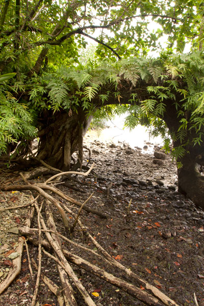
“Gateway Tree”
On the shore just south of the last Japanese structure is a huge tree shaped like an arched gateway. A portion of the tree seems to have bent over and made contact with the ground, where it put down more roots, forming an amazing piece of natural architecture.
Sandy Beaches
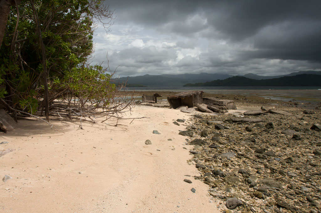
Beautiful stretches of fine copper sand are found on Nahpali’s northwestern and northern coasts. The beaches, however, do not extend all the way out to deep water, giving way instead to shoals of coral rubble and seagrass. The best beach is found where the coastline turns to the east near a pile of concrete slabs that might have been part of a wharf or coastal pillbox. Other ruined structures are scattered along the shore below the high-tide level. There is another smaller beach on the western coast at the southern end of the island.
Surfing
One of two surfable reef-breaks in the area lies on the edge of Kepidauen Deleur, northwest of Nahpali. Visit our surfing page for more details.
- To obtain permission for overnight stays, call McKenzie Senda at +691.320.8682 / 7147 / 4062.
Temwen Vicinity GPS Data
Downloadable GPS Data Files
The following files contain all the packaged GPS data for each of the featured locations in the Temwen Vicinity Eco-Adventure Map Guide.
Three file types are provided. KMZ and KML files are compatible with Google Earth. KML is compatible with Google Maps. GPX files can be imported into ArcGIS (a professional mapping application) and some hand-held GPS devices.
[info]NOTE: All files are free to the public and can be used for any purpose without permission.[/info]
Temwen Island Coastline (2015)
- Temwen Coastline (2015) – temwen-island.kmz (36 kb)
- Temwen Coastline (2015) – temwen-island.gpx (143 kb)
Temwen Island Mangroves (2015)
- Temwen Mangroves (2015) – temwen-mangroves.kmz (298 kb)
- Temwen Mangroves (2015) – temwen-mangroves.gpx (1.3 mb)
Temwen Island Contour Lines (2015)
- Temwen Island Contour Lines (2015) – temwen-contour.kmz (21 kb)
- Temwen Island Contour Lines (2015) – temwen-contour.gpx (78 kb)
Temwen Island Roads (2015)
- Temwen Island Roads (2015) – temwen-roads.kmz (8 kb)
- Temwen Island Roads (2015) – temwen-roads.gpx (24 kb)
Temwen Island Trails & Routes (2015)
- Temwen Island Trails & Routes (2015) – temwen-routes.kmz (13 kb)
- Temwen Island Trails & Routes (2015) – temwen-routes.gpx (49 kb)
Temwen Island Points of Interest (2015)
- Temwen Island Points of Interest (2015) – temwen-places.kmz (33 kb)
- Temwen Island Points of Interest (2015) – temwen-places.gpx (118 kb)
Dolopwuropwur Gun Battery (2015)
Coordinates
The following coordinates correspond with sites featured on the Temwen Vicinity Eco-Adventure Map Guide. It is our dream to eventually create a Pohnpei GPS app that could be uploaded to smartphones and other devices, but for now, these points of interest can be entered manually in a hand-held GPS device as needed.
[info]NOTE: All GPS devices have a margin of error. That margin increases with interference — when there is a thick canopy of trees, during bad weather, or when mountains obstruct the satellite link. The geosynchronous satellites employed when navigating on Pohnpei are located low on the southwestern horizon, such that maintaining a strong connection while hiking on the northeast side of a given mountain range can be difficult. Coordinates on the northeastern slopes of mountains are less accurate than in other locations.[/info]
Temwen Island
| Temwen Causeway South Bridge | —- | 6.843731° 158.313411° |
| Temwen Causeway North Bridge | —- | 6.845294° 158.314911° |
| Peipas Island (Approx. location) | —- | 6.848979° 158.315855° |
| Salong Point | —- | 6.856344° 158.322675° |
| Temwen Elementary School | —- | 6.851509° 158.329239° |
| Current Nahnmwarki’s Residence | —- | 6.851064° 158.332056° |
| Japanese Wharf | —- | 6.855733° 158.332092° |
| Turn-Off to Nan Madol Trail | —- | 6.846941° 158.328562° |
| Nan Madol Trail Parking | —- | 6.845865° 158.330689° |
| Nan Madol Trailhead | —- | 6.844408° 158.330671° |
| End of Temwen Road / Beginning of Footpath | —- | 6.846342° 158.319744° |
| Causeway Store | —- | 6.845268° 158.314783° |
Nan Madol Ruins
| Nan Madol Trailhead | —- | 6.844408° 158.330671° |
| Peinkitel Perimeter Wall North Corner | —- | 6.844326° 158.331118° |
| Peinkitel Entrance | —- | 6.844018° 158.330501° |
| Peinkitel Tomb | —- | 6.844041° 158.330894° |
| Central Peidoh Islet | —- | 6.844092° 158.331846° |
| Sapwohng Islet West Corner | —- | 6.843660° 158.332228° |
| Huge Tree | —- | 6.843828° 158.333042° |
| Central Peilapalap Islet | —- | 6.842964° 158.332899° |
| Central Rasalap Islet | —- | 6.843384° 158.333474° |
| Central Pahseid Islet | —- | 6.843888° 158.333827° |
| Central Usendau Islet | —- | 6.844284° 158.334102° |
| Central Dau Islet | —- | 6.844609° 158.335067° |
| Nan Douwas Islet Entrance | —- | 6.844533° 158.335524° |
| Nan Douwas Islet Sakau Stones | —- | 6.844560° 158.335479° |
| Nan Douwas Islet Sakau Stone | —- | 6.844547° 158.335663° |
| Nan Douwas Islet Central Tomb | —- | 6.844535° 158.335799° |
| Nan Douwas Islet North Tomb | —- | 6.844698° 158.335777° |
| Nan Douwas Islet South Tomb | —- | 6.844390° 158.335724° |
| Central Pohn Douwas Islet | —- | 6.845042° 158.335810° |
| Central Kohnderek Islet | —- | 6.845558° 158.335205° |
| Central Pwalahng Islet | —- | 6.845051° 158.334678° |
| Kahnimweiso Gate (approx.) | —- | 6.843599° 158.337261° |
| Nan Mwoluhsei Sea-wall Entrance | —- | 6.844190° 158.336966° |
| Central Peikapw Sapwawas Islet | —- | 6.843553° 158.334780° |
| Central Pwilak Islet | —- | 6.843159° 158.333909° |
| Central Peinior Islet | —- | 6.842824° 158.334263° |
| Peinering Islet Entrance | —- | 6.842123° 158.333784° |
| Central Perektuhke Islet | —- | 6.841853° 158.332661° |
| Central Pahn Katau Islet | —- | 6.841491° 158.332450° |
| Central Dapahu Islet | —- | 6.842452° 158.332358° |
| Central Usennamw Islet | —- | 6.842585° 158.331411° |
| Central Peitaup Islet | —- | 6.841846° 158.331174° |
| Central Dekehtik Islet | —- | 6.841530° 158.331148° |
| Dorong Islet Perimeter Wall North Corner | —- | 6.840986° 158.329394° |
| Lehnkei (Pool) | —- | 6.840853° 158.331381° |
| Central Peikapw Islet | —- | 6.841907° 158.330170° |
| Idehd Islet Northwest Entrance | —- | 6.841308° 158.330293° |
| Dolen Idehd / Midden | —- | 6.841081° 158.330336° |
| Nan Samwol’s Hole, Idehd | —- | 6.841252° 158.330532° |
| Idehd Islet Northeast Entrance | —- | 6.841288° 158.330555° |
| Isokelekel’s Slingstones, Idehd | —- | 6.841194° 158.330428° |
| Pahn Kadira Islet Sokehs Corner | —- | 6.841195° 158.329971° |
| Pahn Kadira Islet Katau Corner | —- | 6.840766° 158.329374° |
| Pahn Kadira Islet House Foundation | —- | 6.840986° 158.329394° |
| Temple of Nankieilmwahu, Pahn Kadira | —- | 6.841427° 158.329366° |
| Saudeleur’s House Foundation, Pahn Kadira | —- | 6.841484° 158.328948° |
| Pahn Kadira Islet Southwest Entrance | —- | 6.841074° 158.329119° |
| Pahn Kadira Islet Sakau Stone | —- | 6.841186° 158.329195° |
| Pahn Kadira Islet Sakau Stone | —- | 6.841220° 158.329145° |
| Pahn Kadira Islet Sakau Stone | —- | 6.841266° 158.329161° |
| Pahn Kadira Islet Sakau Stone | —- | 6.841305° 158.329112° |
| Pahn Kadira Islet Sakau Stone | —- | 6.841333° 158.329119° |
| Pahn Kadira Islet Madolenihmw (Likapwar) Corner | —- | 6.841558° 158.328740° |
| Pahn Kadira Islet Kitti Corner | —- | 6.842035° 158.329364° |
| Saudeleur’s Bathing Area, Pahn Kadira | —- | 6.841207° 158.329844° |
| Central Pahn Kadira Islet Annex | —- | 6.841268° 158.328655° |
| Central Wasao Islet | —- | 6.841982° 158.328645° |
| Central Reitik Islet | —- | 6.841565° 158.328299° |
| Central Peilam Islet | —- | 6.840527° 158.328599° |
| Central Kelepwel Islet | —- | 6.840592° 158.329081° |
| Central Peinmwek Islet | —- | 6.840670° 158.329624° |
| Central Palakapw Islet | —- | 6.840433° 158.330480° |
| Central Pohnkeimw Islet | —- | 6.840469° 158.326021° |
| Mweiden Kitti (Opening) | —- | 6.839358° 158.327282° |
| Central Pahnmweid Islet | —- | 6.839566° 158.326991° |
| Central Mweid Islet | —- | 6.838856° 158.327817° |
| Boulder Wall, Pahnwi Islet | —- | 6.837491° 158.328793° |
| Upper Pahnwi Islet | —- | 6.838243° 158.329723° |
| Mweiden Weliwel (Opening) | —- | 6.838459° 158.330260° |
| Kepinehd Islet | —- | 6.838917° 158.330884° |
| Mweiden Nahnsapwe (Opening) | —- | 6.839264° 158.331517° |
| Pikalap Islet | —- | 6.839387° 158.331645° |
| Mweidalap (Opening) | —- | 6.839462° 158.331846° |
| Lemensai Islet | —- | 6.839657° 158.331986° |
| Namwenkau (Pool) | —- | 6.839964° 158.332334° |
| Central Lemenkau Islet & Sakau Stones | —- | 6.840380° 158.332956° |
| Lemenkau Islet West Entrance | —- | 6.840332° 158.332482° |
| Pahn Mwasangapw Burial Chamber | —- | 6.841272° 158.334303° |
| Angeir Burial Chamber | —- | 6.841597° 158.334853° |
| Sapwuhtik Burial Chamber | —- | 6.841978° 158.335596° |
| Lukepen Kerian | —- | 6.842601° 158.336477° |
| Kerian Islet Southwest Entrance | —- | 6.842727° 158.336632° |
| Kerian Islet Central Tomb | —- | 6.842821° 158.336771° |
| Kerian Islet North Tomb | —- | 6.842859° 158.336748° |
| Kerian Islet South Tomb | —- | 6.842776° 158.336799° |
| Barge Wreck, Kerian | —- | 6.842461° 158.336651° |
| Huge Sakau Stone, Kerian | —- | 6.842687° 158.336623° |
Dolopwuropwur Battery
| Turn-off to Dolopwuropwur Trailhead | —- | 6.850746° 158.329126° |
| Dolopwuropwur Trailhead | —- | 6.848025° 158.325991° |
| 15 cm Gun #1 | —- | 6.849032° 158.325672° |
| 15 cm Gun #2 | —- | 6.848915° 158.325796° |
| 15 cm Gun #3 | —- | 6.848777° 158.325841° |
| 15 cm Gun #4 | —- | 6.848569° 158.325807° |
| Northern Ammunition Magazine | —- | 6.848901° 158.325669° |
| Southern Ammunition Magazine | —- | 6.848668° 158.325755° |
| Unknown Japanese Foundation | —- | 6.848775° 158.325632° |
| Stone Tower Steps | —- | 6.848635° 158.325571° |
| Japanese Stone Tower | —- | 6.848609° 158.325540° |
| Dug-Out | —- | 6.848583° 158.325497° |
| Japanese Trench North End | —- | 6.848767° 158.325589° |
| Japanese Trench Intersection | —- | 6.848156° 158.324919° |
| Unknown Japanese Structure | —- | 6.848138° 158.325148° |
| Japanese Trench South End / Path Intersection | —- | 6.847964° 158.323712° |
| Cross Island Footpath South End | —- | 6.846107° 158.322737° |
| Cross Island Footpath North End | —- | 6.851214° 158.325296° |
| Dolopwuropwur Peak | —- | 6.848742° 158.325911° |
Around Temwen
| Pohnpei Agriculture & Trade School (PATS) | —- | 6.843103° 158.307976° |
| Marine Environmental Research Institute of Pohnpei (MERIP) | —- | 6.843932° 158.308811° |
| MERIP Apartments | —- | 6.843340° 158.308811° |
| Mwudoketik Island | —- | 6.841213° 158.319636° |
| Mwudokalap Island | —- | 6.839816° 158.317841° |
| Ulidei Island | —- | 6.841085° 158.316101° |
| Dauen Moahk (Channel) West End | —- | 6.845671° 158.314698° |
| Dauen Moahk (Channel) East End | —- | 6.840842° 158.328417° |
| Namwen Nahnningi Stingray Reserve | —- | 6.833504° 158.322414° |
| Nahnningi Island | —- | 6.831781° 158.326057° |
| Mall Island | —- | 6.829152° 158.322269° |
| Nahnningi Snorkeling Pool | —- | 6.828426° 158.326448° |
| Nahnningi Dive Site | —- | 6.826786° 158.324659° |
| Straight Wall Dive Site | —- | 6.832236° 158.334271° |
| Pahn Nahkapw Bridge Dive Site | —- | 6.840180° 158.342650° |
| Kepidauen Nahkapw (Reef Passage) | —- | 6.840793° 158.342252° |
| Nahkapw Island | —- | 6.843777° 158.344200° |
| Pahn Nahkapw Wall Dive Site & Snorkeling | —- | 6.843689° 158.342220° |
| Nipaden Nahkapw Snorkeling Spot | —- | 6.846010° 158.346045° |
| Dekehtik Island | —- | 6.848340° 158.348134° |
| Dekehtik Island Snorkeling Spot | —- | 6.847929° 158.346902° |
| Namwen Na Stingray Reserve | —- | 6.853543° 158.352856° |
| Na North Coast Camping, Swimming & Snorkeling | —- | 6.852748° 158.356608° |
| Nahpali Island | —- | 6.861427° 158.355330° |
| Dekehmwahu Island | —- | 6.860339° 158.359588° |
| Nahpali Island Snorkeling | —- | 6.860600° 158.353214° |
| Nahpali Island Searchlight Drum | —- | 6.862617° 158.356630° |
| Nahpali Island Gun Station #3 | —- | 6.862775° 158.356153° |
| Nahpali Island Gun Station #2 | —- | 6.862848° 158.355992° |
| Nahpali Island Gun Station #1 | —- | 6.862914° 158.355861° |
| Nahpali Island Japanes Coastal Foundation | —- | 6.862591° 158.355395° |
| Nahpali Island Beach | —- | 6.862192° 158.354946° |
| Nahpali Island Beach | —- | 6.863028° 158.355964° |
| Nahpali Island Japanese Coastal Foundation | —- | 6.862075° 158.354758° |
| Nahpali Island Japanese Diesel Engine | —- | 6.861961° 158.354814° |
| Nahpali Island Japanese Foundations | —- | 6.861690° 158.354699° |
| Nahpali Island Japanese Foundation | —- | 6.861393° 158.354617° |
| Nahpali Island Japanese Water Tank | —- | 6.861250° 158.354561° |
| Nahpali Island Japanese Coastal Water Tank | —- | 6.861402° 158.354411° |
| Nahpali Island Gateway Tree | —- | 6.861229° 158.354377° |
| Nahpali Island Japanese Cistern | —- | 6.861601° 158.354808° |
| Dekehmwahu Beach | —- | 6.861424° 158.359777° |
| Na Dive Site | —- | 6.846678° 158.365113° |
| Nanwap Corner Dive Site | —- | 6.871079° 158.356093° |
| Kepidauen Deleur (Reef Passage) | —- | 6.863361° 158.343756° |
| Madolenihmw Bay | —- | 6.861248° 158.306274° |
| Nahpali Surf Break | —- | 6.867134° 158.361762° |
| Nan Madol (Kepidauen Nahkapw) Surf Break | —- | 6.839137° 158.340387° |