

Pahn Sile Waterfall
![]()
![]()
![]()
![]()
![]()
![]()
![]()
![]()
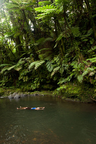
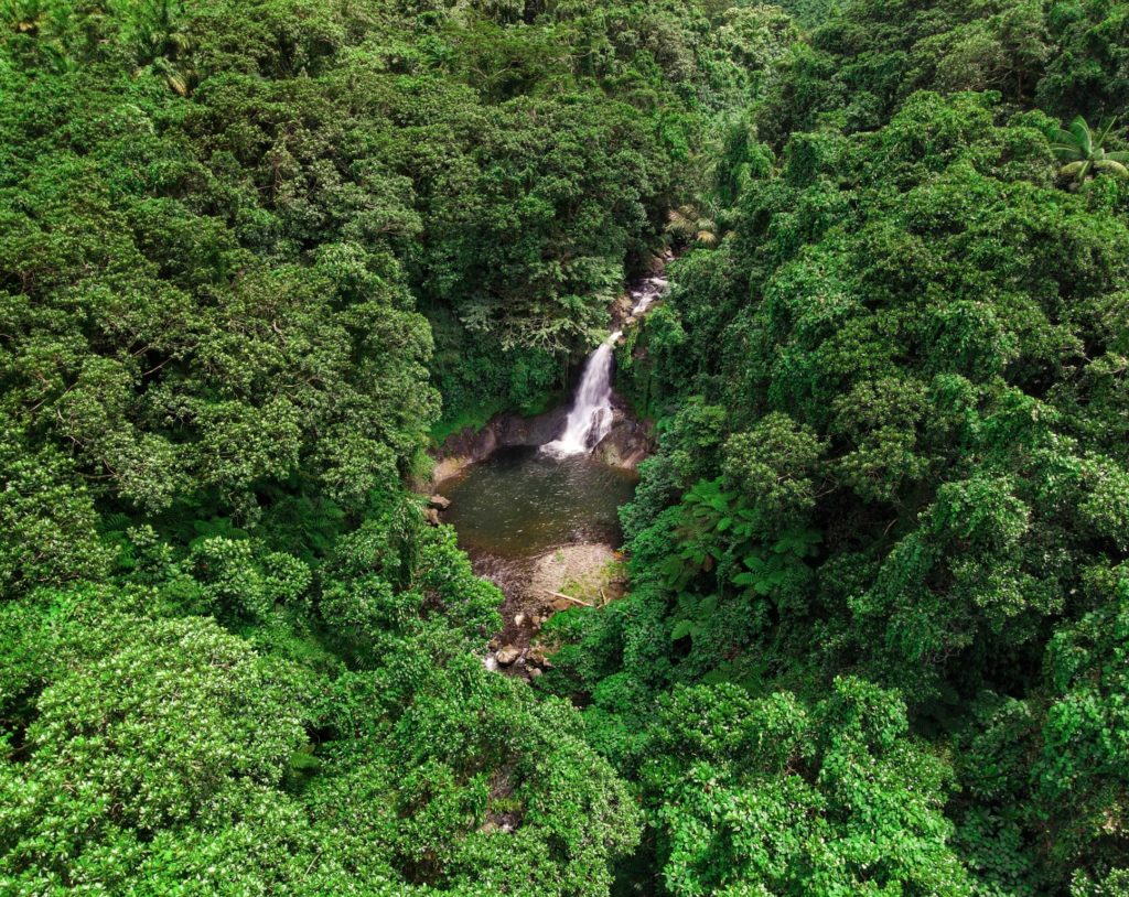
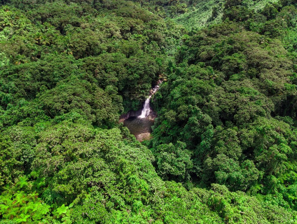
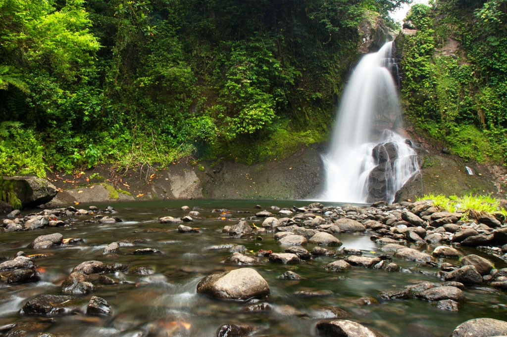
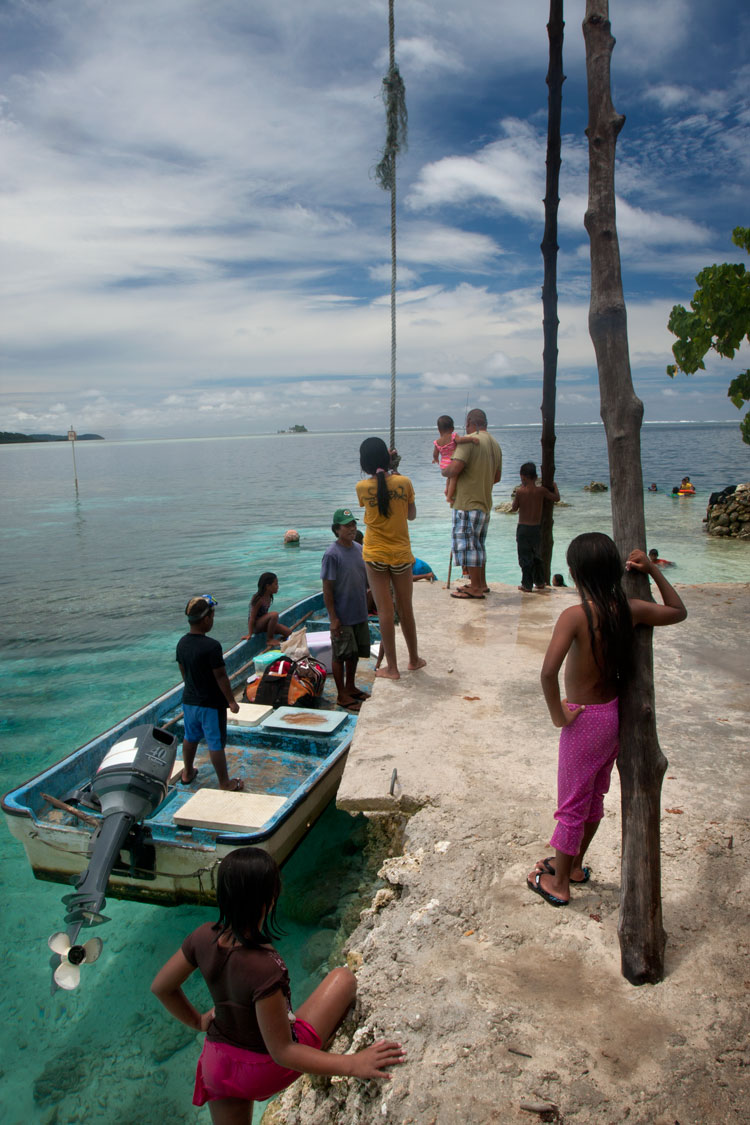
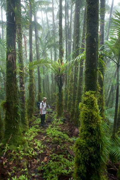
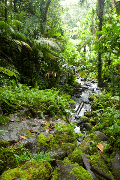
Located on the pristine Senipehn River, Pahn Sile is one of the few waterfalls well into the interior that almost anyone (even small children) can reach without the help of a guide — as long as you keep your eyes open for the branches in the path. A well-maintained trail begins at the end of the unpaved but well-graded coral and gravel road beyond Sapwalap Elementary School and opposite a concrete taxi stop. Houses are found along the path for much of the way, as well as historic rock-lined irrigation canals built by the Japanese. About 0.15 km (164 yd) before reaching the waterfall, a secondary path branches right and descends to a shallow point in the river, where you’ll cross and hug the right bank or walk in the stream as you continue to the falls just around the corner.
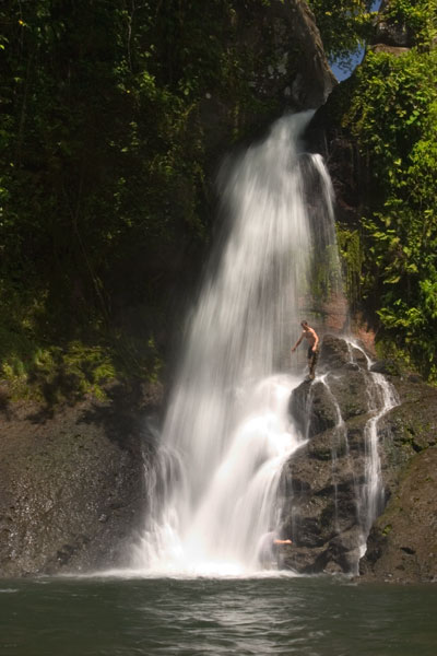
Pahn Sile‘s pool is wide and wonderfully cool, but not especially deep. The falls varies in volume depending on recent rain, gushing through a narrow portal and crashing onto rocks that form the rim of the pool. If you want a view from above the falls, bear left at the branch, proceed for 0.3 km (0.18 mi), and then cut off the trail and head straight toward the sound of the river. There is no path for this last part, but it’s easy enough to move through the forest. There are nice spots for a camp site above the falls in the forest along the path (pack out everything you packed in). In addition to the primary waterfall pool, there’s a small, deep pool just down river that is also an excellent place to swim, shaded by lush ferns and massive trees.
There are no access fees and no permission is needed to visit the falls.
If you would like a guide for the trip to the waterfall contact Raven at (+691)923-1862, he does not charge a fee but we do encourage you to tip him for his time.
- Plan for 3 hours round-trip for this excursion.
Snorkeling Pohnpei’s East Side
![]()
![]()
![]()
![]()
Temwen Vicinity
Pahn Nahkapw Wall
The best snorkeling in the area is west of Nahkapw (island) along the edge of the reef, where a coral wall drops quickly off into Pahn Nahkapw‘s blue hole. Fish are abundant here and the coral is thriving. Start at the north tip of Nahkapw and follow the reef around. To the east you’ll see the massive basalt boulders that make up the island’s Nan Madol-era breakwall.
Kepindausiso
The reef walls north, west, and south of Dekehtik (island), at the northeast end of Pahn Nahkapw, offer plenty of nice underwater views and crystal-clear water. This portion of the hole is referred to as Kepindausiso –“below the noble’s channel”.
Namwen Na Stingray Sanctuary
This reserve lies between Nahpali, Dekehmwahu, and Na (islands). It’s a moderately deep pool in the middle of shallow, sandy reef flats populated by a large number of stingrays (we saw more than fifteen in under an hour). You can swim out to the western edge from the southern tip of Nahpali or explore the eastern side from Na. There can be some strong currents coming from the northeast, so be alert.
Northern Na Island Coast
Na‘s northern coast offers narrow sandy beaches and a swath of beautiful, crystal-clear water over a sandy bottom. Further out, the floor turns to beds of seagrass. There are plenty of stingrays to see in the area. When walking in the shallows, be alert and shuffle your feet to avoid potentially serious accidents.
- Visit our Island page for more about this location.
Nahpali Island
Nahpali‘s underwater sights are all around the west side and most easily accessed from the Japanese Wharf at the edge of the reef.
- Visit our Island page for more about this location.
“Nan Madol”
The water around the northeastern perimeter of Nan Madol is usually too rough and/or murky for sub-surface exploration, but the reef pool southeast of Lemenkau can be nice on calm days and at mid to high tides. At other times, it’s either difficult to reach or has waves breaking over it.
Namwen Nahnningi Stingray Sanctuary
Similar to the reserve near Na, this marine protected area consists of several deep pools in the middle of the reef shelf with sandy bottoms, good visibility, and healthy coral populations around the edge. Stingrays are abundant and reef fish diverse. The pools are a short swim from Nahnningi (island) (a.k.a. “Joy”).
Joy / Nahnningi / Para Nuii
Southeast of Nahnningi is a circular pool on the edge of the fringing reef. There’s a narrow opening on the ocean side that allows water and fish to flow in. Depending on the tides, this place can have amazing numbers of reef fish, but it’s too rough for snorkeling when the Northeasterlies are blowing during the winter. You can snorkel to the pool from Nahnningi.
Nahpali Island
![]()
![]()
![]()
![]()
![]()
![]()
![]()
![]()
![]()
![]()
![]()
![]()
![]()
Nahpali is a long, narrow reef island running roughly northeast-southwest and located northeast of Temwen Island in Madolenihmw Municipality. The island is privately owned by the Senda family and has remained largely undeveloped. In 1836, a war that erupted between the crew of a visiting British whaleship, the Nahnmwarki (paramount chief of Madolenihmw), and a rival chief (the Wasai), spilled over onto the island. After the whaleship ran aground, its cargo was transferred to Nahpali, where it was later stolen by the brother of the Nahnmwarki, called Nahnawa. The whalers and Nahnawa’s men fought on the island, where Nahnawa temporarily got the upper hand and killed the captain of the ship and three others. Eventually however, with the help of the Wasai, who was based on Na Island and coveted the Nahnmwarki title, the whalers overcame the Nahnmwarki and his brother and murdered them. During the 1930s, Nahpali was occupied by the Japanese military, which operated a gun battery and searchlight station near the northern end. Today, the island is forested and scattered with the remains of the gun stations and other Japanese structures, including water storage tanks and steps that once led up to an elevated wooden barracks (now long gone). All of the suitable camping areas lie on the western and northern coasts and the swimming and snorkeling is all along the reef wall west of the island, while the eastern side descends into impassable mangrove swamps.
Attractions
110 cm Searchlight
As part of their fortification of Nahpali, the Japanese mounted a 110 cm searchlight at the northeast end of the island, closest to the channel opening. They probably intended to use the light to spot enemy ships attempting to pass inside the reef, but it seems unlikely that they ever got to use it in battle. The May Day bombardment of Pohnpei by American warships focused primarily on the targets of highest import — Kolonia Town, Sokehs Mountain, and Lenger Island — and it’s doubtful that American vessels were anywhere near Nahpali. Allied bombers, however, may have played a part in the destruction of this piece of hardware. The searchlight drum now rests in the sandy shoals north of the concrete platform where it was originally installed. The platform is broken into several pieces, but it’s not clear whether the damage was caused by a bomb blast or just the action of tides, waves, and erosion over nearly 70 years. Other bits of the light are scattered around in the water nearby.
8 cm Gun Stations
Duane Denfeld’s 1979 archaeological overview of Pohnpei’s historical sites indicates four 8 cm gun stations on Nahpali (based on American intelligence gathered through aerial photography rather than an actual visit to the island). During our quick survey of Nahpali, we were only able to locate three of the stations and one of them was severely deteriorated. No guns remain, but the concrete defensive structures are still there — albeit very overgrown.
Other Japanese Structures
Most of the other structures found on the island are clustered around the west side. There’s a series of foundations that might have belonged to a barracks, several hulking cisterns of various types, and a diesel engine.
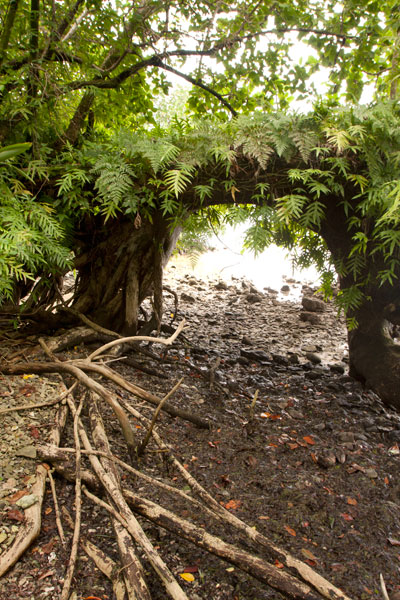
“Gateway Tree”
On the shore just south of the last Japanese structure is a huge tree shaped like an arched gateway. A portion of the tree seems to have bent over and made contact with the ground, where it put down more roots, forming an amazing piece of natural architecture.
Sandy Beaches
Beautiful stretches of fine copper sand are found on Nahpali’s northwestern and northern coasts. The beaches, however, do not extend all the way out to deep water, giving way instead to shoals of coral rubble and seagrass. The best beach is found where the coastline turns to the east near a pile of concrete slabs that might have been part of a wharf or coastal pillbox. Other ruined structures are scattered along the shore below the high-tide level. There is another smaller beach on the western coast at the southern end of the island.
Surfing
One of two surfable reef-breaks in the area lies on the edge of Kepidauen Deleur, northwest of Nahpali. Visit our surfing page for more details.
- To obtain permission for overnight stays, call McKenzie Senda at +691.320.8682 / 7147 / 4062.
(Central) Madolenihmw GPS Data
Downloadable GPS Data Files
The following files contain all the packaged GPS data for each of the featured locations in the (Central) Madolenihmw Eco-Adventure Map Guide.
Three file types are provided. KMZ and KML files are compatible with Google Earth. KML is compatible with Google Maps. GPX files can be imported into ArcGIS (a professional mapping application) and some hand-held GPS devices.
[info]NOTE: All files are free to the public and can be used for any purpose without permission.[/info]
Dolen Merewi Hike (2015)
Madolenihmw Bay Area Attractions (2015)
Nankep Waterfall Hike (2015)
Pahnsapw Waterfalls Hike (2015)
Pahn Sile Waterfall Hike (2015)
Pohnpaip Petroglyphs (2015)
Coordinates
The following coordinates correspond with sites featured on the (Central) Madolenihmw Eco-Adventure Map Guide. It is our dream to eventually create a Pohnpei GPS app that could be uploaded to smartphones and other devices, but for now, these points of interest can be entered manually in a hand-held GPS device as needed.
[info]NOTE: All GPS devices have a margin of error. That margin increases with interference — when there is a thick canopy of trees, during bad weather, or when mountains obstruct the satellite link. The geosynchronous satellites employed when navigating on Pohnpei are located low on the southwestern horizon, such that maintaining a strong connection while hiking on the northeast side of a given mountain range can be difficult. Coordinates on the northeastern slopes of mountains are less accurate than in other locations.[/info]
Dolen Merewi
| Dolen Merewi Turn-Off | —- | 6.882208° 158.290005° |
| Road Branching – bear left | —- | 6.881983° 158.278225° |
| Dolen Merewi Trailhead | —- | 6.880292° 158.274669° |
| Private Residence | —- | 6.880442° 158.274156° |
| Look-Out Point | —- | 6.883006° 158.270929° |
| Dolen Merewi True Summit | —- | 6.882815° 158.270869° |
Madolenihmw Bay Area
| Lukop, Metipw & Kepine Turn-Off | —- | 6.898141° 158.315994° |
| Road Branching – bear left for Lukop and Metipw; bear right for Kepine and Takaiuh | —- | 6.889728° 158.314120° |
| Bridge | —- | 6.884719° 158.313625° |
| Japanese Agricultural Plots | —- | 6.886711° 158.311515° |
| Nanpahlap Trailhead | —- | 6.876366° 158.318225° |
| Nanpahlap Summit | —- | 6.875491° 158.315744° |
| Tahio Trailhead | —- | 6.874010° 158.317018° |
| Japanese Dug-Out | —- | 6.873007° 158.316122° |
| Japanese Trench | —- | 6.872754° 158.315133° |
| Japanese Tunnel | —- | 6.873264° 158.314119° |
| Abandoned Community Hut (nahs) | —- | 6.872849° 158.314316° |
| Takaiuh Summit | —- | 6.872128° 158.310713° |
| Rocky Hill | —- | 6.874429° 158.308532° |
| Dauen Sapwalap Entrance | —- | 6.876938° 158.308196° |
| Japanese Rice Paddies Turn-Off | —- | 6.888314° 158.296764° |
| Japanese Rice Paddies & Irrigation Canals | —- | 6.887325° 158.303652° |
| Metipw Causeway / Launch | —- | 6.878051° 158.333074° |
| Mwudokolos Island | —- | 6.883576° 158.336525° |
| Dahu Reirei Island | —- | 6.888759° 158.344288° |
| “Channel Island” | —- | 6.899494° 158.342153° |
| Nanwap Marine Protected Area | —- | 6.872988° 158.353673° |
| Nahpali Island Dock | —- | 6.861877° 158.354457° |
| Salong Point, Temwen Island | —- | 6.856468° 158.322737° |
| MERIP Boathouse | —- | 6.844010° 158.308539° |
| Madolenihmw Ice Dock | —- | 6.849520° 158.302712° |
| Madolenihmw Bay Scenic Point | —- | 6.855273° 158.295686° |
Nankep Waterfall
| Nankep Waterfall Turn-Off | —- | 6.858738° 158.291440° |
| Bridge | —- | 6.858789° 158.291453° |
| Nankep Waterfall Trailhead | —- | 6.859867° 158.286390° |
| Nankep Waterfall | —- | 6.859335° 158.283177° |
Nankepinmerepw Valley
| Nankepinmerepw Turn-Off | —- | 6.873704° 158.286552° |
| Nankepinmerepw Trailhead | —- | 6.875185° 158.273305° |
| Senipehn Footbridge | —- | 6.876110° 158.271732° |
| Private Residence | —- | 6.877294° 158.263737° |
| Small Falls & Swimming Pool | —- | 6.877911° 158.242150° |
| Prismatic Basalt Quarry Site / Falls | —- | 6.878689° 158.240613° |
| Nankepinmerepw Waterfall | —- | 6.880498° 158.239370° |
| Block Waterfall | —- | 6.882766° 158.238850° |
| Trail Branching – bear right for Nahnalaud; bear left for “The Cave.” | —- | 6.888859° 158.288880° |
| “The Cave” | —- | 6.866427° 158.230917° |
| USGS Benchmark | —- | 6.874333° 158.230076° |
| Nahnalaud Look-Out Point #2 | —- | 6.874333° 158.230076° |
| Nahnalaud Look-Out Point #1 / Observed Summit | —- | 6.873876° 158.228524° |
| Nahnalaud True Summit | —- | 6.873323° 158.228724° |
| Nahnalaud Mountain Shelter | —- | 6.874001° 158.227374° |
Pahnsapw Waterfalls
| Pahnsapw Waterfall Turn-Off | —- | 6.871427° 158.285654° |
| Sakau Market | —- | 6.871839° 158.285500° |
| Sakau Market | —- | 6.871234° 158.285637° |
| Road Branching – bear right | —- | 6.870202° 158.282381° |
| Bridge | —- | 6.870052° 158.280071° |
| Road Branching – bear right | —- | 6.870060° 158.280108° |
| Road Branching – bear left | —- | 6.869425° 158.278666° |
| Pahnsapw Trailhead | —- | 6.868207° 158.278527° |
| Silbanuz Residence | —- | 6.867969° 158.278513° |
| Pahnsapw Lower Falls | —- | 6.865171° 158.277289° |
| Hidden Pool | —- | 6.865183° 158.277071° |
| Pahnsapw Upper Falls | —- | 6.864683° 158.277100° |
Pahn Sile Waterfall
| Pahn Sile Waterfall Turn-Off | —- | 6.873704° 158.286552° |
| Taxi Stop | —- | 6.873691° 158.286771° |
| Bridge | —- | 6.873629° 158.286431° |
| Road Branching – bear left | —- | 6.875588° 158.281340° |
| Road Branching – bear left | —- | 6.875802° 158.276411° |
| Road Branching – bear left | —- | 6.875179° 158.273294° |
| Pahn Sile Trailhead | —- | 6.873597° 158.269375° |
| Trail Branching – bear right | —- | 6.873598° 158.269382° |
| Trail Branching – bear left | —- | 6.873662° 158.269032° |
| Japanese Irrigation Canal | —- | 6.871403° 158.266674° |
| Japanese Irrigation Canal | —- | 6.870612° 158.265405° |
| Stream Crossing | —- | 6.866702° 158.264493° |
| Trail Branching – Bear right for waterfall & pool; left to see the falls from above | —- | 6.866048° 158.264342° |
| Senipehn River Crossing | —- | 6.865499° 158.263650° |
| Pahn Sile Waterfall Pool | —- | 6.864499° 158.263151° |
| Pahn Sile Waterfall | —- | 6.864467° 158.263028° |
| Break north From trail to see the falls from above | —- | 6.864209° 158.262860° |
Pohnpaip Petroglyphs
| Pohnpaip Petroglyphs Turn-Off | —- | 6.886941° 158.291017° |
| Bridge | —- | 6.886789° 158.290910° |
| Pohnpaip Trailhead | —- | 6.888161° 158.289097° |
| Herson Residence | —- | 6.887435° 158.288495° |
| Pohnpaip Outcropping | —- | 6.887621° 158.288259° |
| Magical Door of Pohnpaip | —- | 6.887551° 158.288181° |
| Takain Pahsu | —- | 6.888396° 158.288694° |
| “Hindquarters Rock” | —- | 6.888665° 158.288933° |
| “Enveloped Cross Rock” | —- | 6.888859° 158.288880° |
Pohnpei Diving – East Side Sites
“Straight Wall”
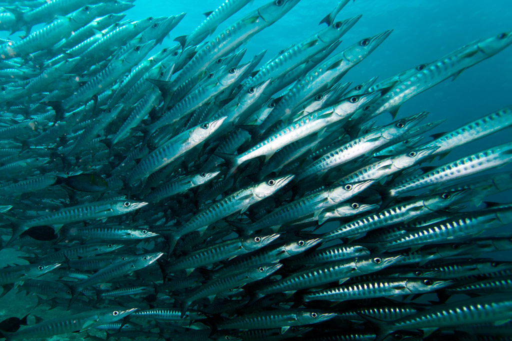
This dive is on the outer edge of the long, straight fringing reef east of Nahnningi (Joy) Island. It’s a good place to see schools of tuna and barracuda hanging out beyond the wall. It’s also one of the few places you might spot sea turtles. This side of the island is very exposed to winds, so summer is the best bet for good conditions. 1-37 meters. Advanced.
“Joy / Nahnningi”
This spot is known by most people as “Joy,” which used to be the name of the island nearby (the local name of the island is Nahnningi). The dive is actually in the small bay-like channel south of Nahnningi on the outer edge of the barrier reef. One informant reported seeing huge mantas here, larger than any at “Manta Road” or “Ros”. Other sights include schools of barracuda and the occasional sea turtle. 1-37 meters. Intermediate.
“Nan Madol” (Kahnimweiso)
This is spot, east of the ruins of Nan Madol (not far beyond Kerian islet), garnered fame when divers apparently discovered a line of pillars on the bottom that they believed were related to the story of Kahnimweiso — a fabled stone city that is said to have pre-dated Nan Madol. The pillars were later proved to be natural coral formations, but the site is still intriguing. Anemones, pipefish, hydroids, and a whole lot of other reef fish can be found in the area. The problem is that the visibility is often terrible and the water can be very rough. 3-21 meters. Best at 18-21 meters. Advanced.
“Pahn Nahkapw”
This dive begins in front of the boulder break-wall off Nahkapw‘s western shore and follows the steep reef wall as it curves around to the east toward Kepidauen Nahkapw. Water clarity at this spot can be absolutely incredible and the reef is alive with fish of many types. Shark sightings are a strong possibility in this incredibly deep blue hole — especially below 18 meters. 2-30 meters. Any tide. Novice.
“Na”
This wall dive is located east of Na on the outer slope of the reef. Staghorn and elkhorn coral, sting rays, sharks, manta rays, and the usual gamut of reef fish are what to look for. The water can be very rough in this area as it’s directly exposed to the northeasterlies, so winter diving is out of the question. 2-29 meters. Advanced.
“Nanwap Corner”
This wall dive in the Nanwap Marine Protected Area is located on the north side of Kepidauen Deleur, on the opposite side of the pass from Nahpali. This is a great place for sharks and rays, but it’s also one of the healthiest spawning sites for reef fish in Pohnpei. However, the pass (and the general area) has a reputation for rough water, and the currents can be intense. Mid-summer diving, when winds are minimal, is the safest. Best on an in-coming tide. Advanced.
There’s also good diving and snorkeling around the blue holes in the inner reef, where you’re more protected from waves and current. The coral is nice here and there are usually plenty of fish around. Best at slack-tide. Intermediate.
- Entering the MPA requires a permit. Visit our MPA page for details.
“Areu North / South” (Kepidauen Alohkapw)
Drift-dives can be done on either the north or south edges of Alohkapw Pass (Kepidauen Alohkapw), beginning along the outer barrier reef walls and moving in to the inner reef. There have been reports of large of schools of reef sharks below 30 meters. Best on an in-coming tide. Advanced.
“Areu Wall”
Located along the wall of one of the inner reefs west of Kepidauen Alohkapw, this site is about the little creatures — invertebrates, small reef fish, sponges, tunicates, anemones, and soft coral. You can also find sea fans (18-24 meters), sea whips, white-tip reef sharks, and barracuda here. 2-34 meters. Currents can be strong at times. Best at 6-18 meters on an in-coming tide. Novice-Intermediate.
“Areu Avenue”
This is another inner lagoon wall-dive similar to “Areu Wall” but in a different location nearer to Kepidauen Alohkapw. Many of the same sights can be found, including sea fans at depth. 2-30 meters. Currents can be strong at times. Best at 6-18 meters on an in-coming tide. Intermediate.
ACKNOWLEDGMENTS
We’d like to extend a big kalahngan to Mike Viti, John Ranahan, and Karino Olpet for sharing their in-depth, first-hand knowledge about SCUBA diving on Pohnpei — without which this page could not have been created. Images licensed from www.shutterstock.com.
Paddling Around Central Madolenihmw
![]()
![]()
![]()
![]()
![]()
![]()
![]()
![]()
![]()
![]()
![]()
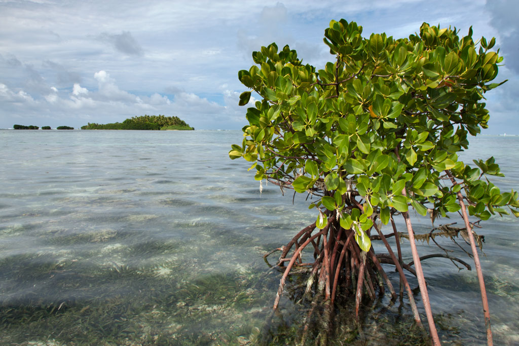
Dauen Sapwalap / Senipehn Mangrove Reserve
Dauen Sapwalap is the largest drainage in Madolenihmw, a wide, meandering channel that cuts through the mangrove forests from Kitamw and eventually empties into Madolenihmw Bay. Although the Lehdau River (Pillapen Lehdau) is probably the largest contributor to this major estuary, the two are not synonymous; the channel is also fed by three other watercourses, including the Kitamw Stream (Pilen Kitamw), Pwadapwad Stream (Pilen Pwadapwad), and River of Sekere Riau (Pillapen Sekere Riau). According to legend, a powerful demi-god named Lapongo — the same character involved in the story of Takaiuh peak — dug out the channel with his penis. The matriarch of the Lasialap Clan — a great eel responsible for the creation of Lipwentiak in Kitti and whose tail formed the great mountain in Nett, Pohnlehr — was also said to have dwelt in this channel for many years, terrorizing the local inhabitants.
During the 1889-1890 wars between the Spanish and Pohnpeians, which began in Ohwa and concluded in Kitamw, two contingents of Spanish troops were dispatched at the mouth of Dauen Sapwalap and attempted to move up both banks of the Pillapen Lehdau (Lehdau River) to reach a small half-finished fort built on a low hill by the Pohnpeian fighters. The first group of soldiers got terribly lost in the tangled forests and happened upon the fort only by mere chance. The second group was forced off-route by a seemingly supernatural flood and also ended up lost, camping overnight at Elieliwi before joining the fray. The assault cost the Spanish 21 men, and in the end the Pohnpeians merely withdrew and yielded a position that had meant little to them from the beginning.
In the last decade, the estuary became part of the Senipehn Mangrove Forest Reserve and afforded some environmental protections; tree-cutting, fishing, and gathering of other natural resources in the area is prohibited in most circumstances. Paddlers can explore the 2.6 km (1.62 mi) primary channel and its side passages by launching near the Lehdau River bridge, at the end of the road near Tahio, at the Madolenihmw “Ice Dock”, or at the MERIP boathouse.
- Entering the mangrove reserve requires a permit. Visit our MPA page for details.

Takaiuh Peak
While Sokehs Rock is the stand-out natural feature in the north, in Madolenihmw that title certainly goes to Takaiuh (“standing rock”), a majestic conical hill-island on the north side of the bay. Westerners called this feature “Sugarloaf” after the molded cones of sugar that were popular in Western Europe as early as 1470, but the local name and its story are much more interesting (see Madolenihmw Bay Area page for more).
Paddlers can get right up close to the iconic hill for a view from the water that is better than from anywhere on land. There’s also good fun to be had noodling around in the mangrove forests on the eastern shore (at high tide). A sweet spot to stop for a picnic lunch is the top of an exposed rocky rise 0.36 km (0.22 mi) northwest of the peak (no mangroves skirt this bit of the shore).
Pahn Dieinuh
Pahn Dieinuh, the southern point of the Dolopwail peninsula, is significant historically for the 1836 conflict that began there between the visiting British whaleship Falcon and two rival Pohnpeian chiefs — Luhk en Kesik ( the Nahnmwarki) and the Wasai, the first and second ranking men in the royal line, respectively. Things got ugly when the Nahnmwarki made a move to seize the ship and its cargo. When the ship attempted to flee, it ran up on the reef. The cargo was transferred to Nahpali Island and then stolen a month later by the Nahnmwarki‘s brother, Nahnawa. A battle ensued on Nahpali between Nahnawa‘s party and the whalers, ending in the deaths of the ship’s captain and three other sailors. The Wasai, who had been challenging the Nahnmwarki‘s authority for some time, seized this opportunity to rid the land of his enemy by joining the crews of other whaleships in hunting down both Nahnawa and the Nahnmwarki. Fighting continued for several days until the Nahnmwarki was shot and Nahnawa captured and hanged from the yardarm of the whaleship Lambton. Both bodies were buried at Pahn Dieinuh, and the Wasai assumed the position of the Nahnmwarki. There isn’t much of anything to see at Pahn Dieinuh now, but it’s a good spot for a break mid-route. The closest launch points are MERIP boathouse, the “Ice Dock”, and the Metipw launch.
Mwudokolos Island
In addition to the seven islands (Nahpali, Dekemwahu, Na, Dehketik, Nahkapw, Nahnningi, and Mall) found around Temwen, there are three small islands to the north that shouldn’t be missed. The first of these — Mwudokolos — is found a half-kilometer (0.33 mi) northeast of Metipw and easily accessed from the coral-dredged causeway/dock found there (ask at the nearest house for permission to launch). Archaeologist Arthur Saxe believed that the island was tied to Nan Madol in some way and that it might even be a man-made island, but Japanese archaeologists working on the island in recent years have found no hard evidence to support that idea. They did discover prehistoric stone structures and a house platform that dates to the Nahnmwarki Period of Nan Madol (post-1700). Glass beads, sherds, and clay pipes were also found, suggesting that Mwudokolos was occupied by foreign traders in the late 1800s. The island is privately owned, but unoccupied.
- To obtain permission for day visits or overnight stays, call Sesuko Hadley at +691.320.2540.
Dahu Reirei Island
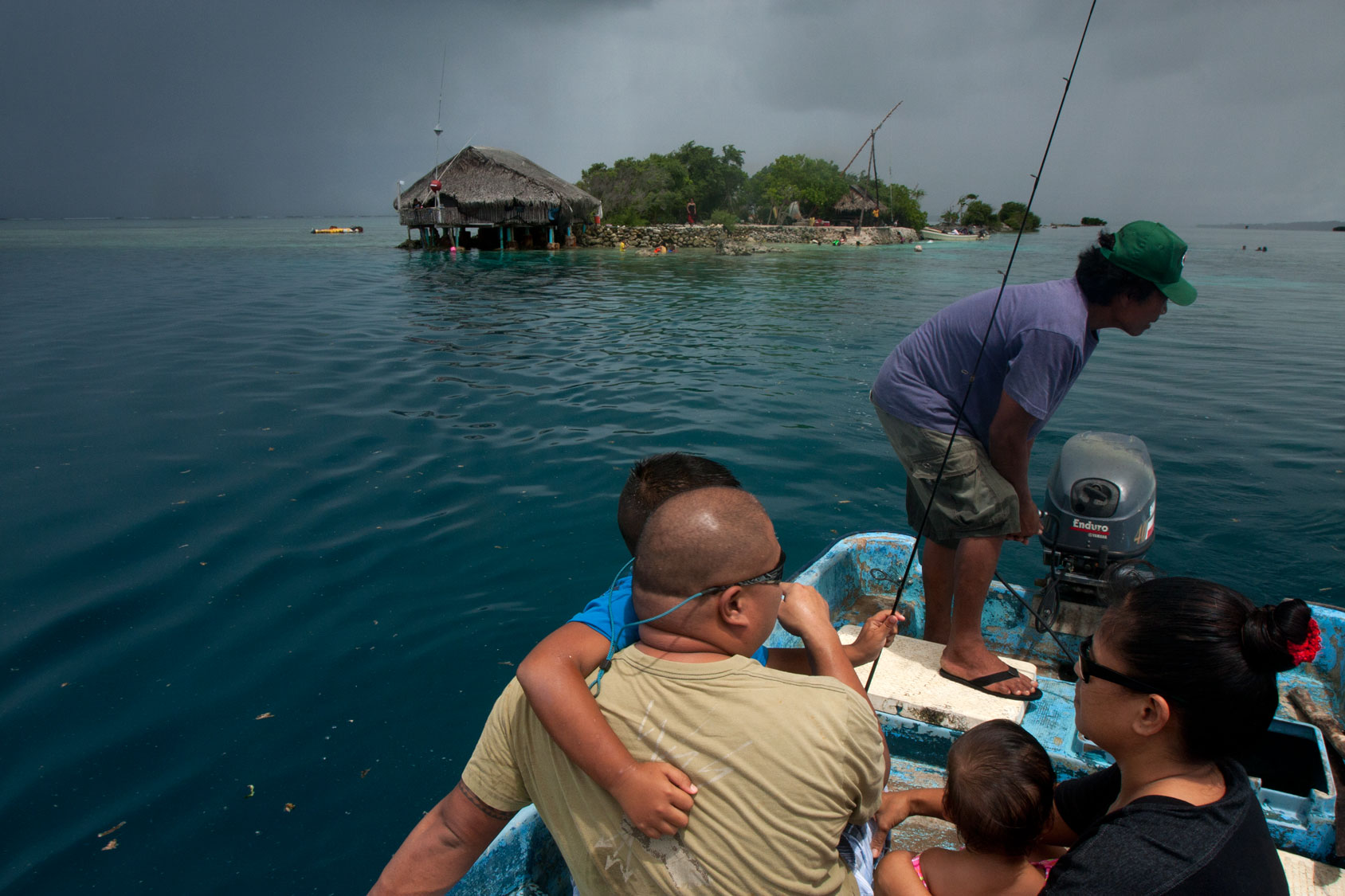
From Mwudokolos, paddlers can continue 1.8 km (1.13 mi) further north through the easternmost of two dredged reef channels to reach Dahu Reirei (“long channel”), a narrow, man-made islet with huts for picnickers and campers and lots of pleasant swimming and snorkeling. When we say this island is narrow, we mean narrow (10 meters wide). Unless you like being crammed together elbow-to-elbow, avoid the place on weekends and holidays. It’s also not a place to be on intensely hot days (there are no trees large enough to provide shade) or during bad weather (the island is hardly a meter above sea level at high tide). On partly-cloudy weekdays, however, it can be heavenly. The surrounding water is generally crystal-clear and the reefs, which consist mainly of varieties of staghorn coral, are surprisingly healthy and relatively well-populated with reef fish. Small thatched huts along the length of the strip can be rented for the day or overnight.
- To make reservations for day visits or overnight stays and to arrange boat transport, call Joseph Helgenberger at +691.320.2229.
Lepin Dau (“Channel Island”)
The final island covered in this sector (it’s just off the edge of the Central Madolenihmw map, but appears on the U & Northern Madolenihmw map) is claimed by the same family as Dahu Reirei and has no official name, but as it lies adjacent to the primary channel every boat in the area uses to go from Areu and Ohwa to Madolenihmw Bay, it’s known as Lepin Dau or “Channel Island.” This island is larger and higher than Dahu Reirei and has some welcoming tree-cover (mostly pandanus). The channel on the west side is a nice spot to snorkel at slack tide, but at other times, the current can be so strong that snorkelers and swimmers run a strong risk of being swept away. A better spot for snorkeling is in the blue holes around the southeast side — well out of the path of the current. Here you can find beautiful coral grottoes, huge schools of needlefish, barracuda, cuttlefish, trumpetfish, angelfish, and parrotfish, an odd seasnake (the latter are venomous, but so passive that they pose little danger to snorkelers), and from time to time even eagle rays and small green turtles. It’s a fantastic picnic destination for paddlers.
- You don’t really need to get permission to make day visits to “Channel Island,” but overnighters should call Joseph Helgenberger at +691.320.2229.
Nanwap Marine Protected Area
The reefs on the north side of Kepidauen Deleur make up the Nanwap Marine Protected Area (MPA), a marine reserve with excellent snorkeling and diving. The best place to snorkel is about 1.3 km east of Metipw in a protected reef hole, but watch for strong currents.
- Visit the Madolenihmw Bay Area page for a detailed description of this location.
- Entering the MPA requires a permit. Visit our MPA page for details.
Paddling Distances Around Central Madolenihmw
| Starting | Ending | Distance (km) | Distance (mi) | |
| “Ice Dock” | —- | Tahio* | 3.12 km | 1.94 mi |
| “Ice Dock” | —- | Sekeren Senipehn | 2.5 km | 1.6 mi |
| Sekeren Senipehn | —- | Dauen Wetiak | 1.7 km | 1.0 mi |
| Dauen Wetiak | —- | Dauen Sapwalap | 1.3 km | 0.8 mi |
| Dauen Sapwalap | —- | Pilen Kitamw (Kitamw Stream) Bridge | 2.6 km | 1.6 mi |
| “Ice Dock” | —- | Takaiuh Shore* | 2.45 km | 1.5 mi |
| “Ice Dock” | —- | Pahn Dieinuh* | 2.6 km | 1.62 mi |
| Takaiuh Shore* | —- | Diadi | 3.44 km | 2.1 mi |
| Japanese Wharf, Temwen Is. | —- | Diadi | 0.99 km | 0.61 mi |
| MERIP* | —- | Pahn Dieinuh | 2.48 km | 1.54 mi |
| MERIP* | —- | Salong Point, Temwen Is. | 2.2 km | 1.4 mi |
| Salong Point, Temwen Is. | —- | Japanese Wharf, Temwen Is. | 1.0 km | 0.64 mi |
| Japanese Wharf, Temwen Is. | —- | Nahpali Island | 2.63 km | 1.63 mi |
| Nahpali Island | —- | Metipw Launch | 2.59 km | 1.61 mi |
| Diadi | —- | Metipw Launch | 2.8 km | 1.75 mi |
| Kepidauen Deleur | —- | Nanwap Marine Protected Area (MPA) | 1.24 km | 0.77 mi |
| Metipw Launch | —- | Mwudokolos Is. Circumnavigation | 1.4 km | 0.9 mi |
| Metipw Launch | —- | Dahu Reirei Is. | 1.86 km | 1.2 mi |
| Dahu Reirei Is. | —- | “Channel Island” (see U Municipality & Northern Madolenihmw guide) | 1.53 km | 0.95 mi |
| Metipw Launch | —- | Pilen Semwei | 2.61 km | 1.62 mi |
*Silted-in reef. This segment may be difficult or impossible to traverse at low tide.
Mwudokolos Island
Mwudokolos is found a half-kilometer (0.33 mi) northeast of Metipw and easily accessed from the coral-dredged causeway/dock found there (ask at the nearest house for permission to launch if you’re paddling out). The privately owned, but uninhabited, island has prehistoric stone structures that date to the Nahnmwarki Period of Nan Madol (post-1700). Glass beads, sherds, and clay pipes have also been found there by archaeologists, suggesting that Mwudokolos was occupied by foreign traders in the late 1800s. There’s some nice swimming and snorkeling northeast of the island.
Dekehmwahu Island
Uninhabited little Dekehmwahu (“good island”) is located just east of Nahpali in Madolenihmw Municipality. It’s a rough oval with a couple of small, sandy beaches and a few places to pitch a tent. The best beach is at the northwestern end, while the most practical camp site is on the southeast coast. Mangroves skirt most of the western coast. With a few exceptions, the surrounding ocean is shallow and covered with beds of seagrass, but good snorkeling can be found not far to the south at the Namwen Na Stingray Sanctuary (a short swim away). Surrounding shallow reefs make the island difficult to reach by boat, except at the highest tides, but it’s a great place for kayakers to visit. Currents can be extremely strong in the area at certain times.
- To obtain permission for overnight stays, call McKenzie Senda at +691.320.8682 / 7147 / 4062.
Dau Reirei Island
Dahu Reirei (“long channel”) is a long, narrow, man-made islet constructed on a shallow reef with several huts for picnickers and campers and lots of pleasant swimming and snorkeling nearby. The tiny place can get uncomfortably crowded on weekends and holidays, but is wonderful at other times. One of Dahu Reirei‘s biggest draws is its namesake — the crystal-clear channel along the west side, which is host to many varieties of staghorn coral and swarms of reef fish; it’s a magical place to swim. The reef walls north of the island, however, are better for snorkeling (follow the reef as it curves east and north). Note that Dahu Reirei is really about being IN the water as the island itself isn’t much of anything. And in the water is exactly where you’ll want to be when the temperatures soar (there is little shade) and when the land shrinks at high tide (the island is hardly a meter above sea level). The family of the owner lives in a stilt-hut at the north end of the island.
- To make reservations for day visits or overnight stays and to arrange boat transport from Ninleu, call +691.924.2229. There is an admission fee for the island so be sure to ask for quote if you would like to book a trip.
Nahnalaud — the Big Mountain
The Big Mountain
![]()
![]()
![]()
![]()
![]()
The highest mountain in the Federated States of Micronesia (FSM) is called Nahnalaud (which means “big mountain”) and is located almost in the exact middle of Pohnpei Island. Pohnpeians consider the mountain sacred and regard it with respect and reverence, though most people have never been there because of the long, difficult hike involved. Local deer hunters and upland sakau farmers are the most frequent visitors to the highland region. A limited number of foreigners also attempt the summit.
In reality, Nahnalaud is not a single mountain but rather the highest peak in Pohnpei’s contiguous central mountain system, which separates the five chiefdoms. The primary central ridge runs from west to east and then curves north toward U not far beyond Nahnalaud. Additionally, a secondary ridge runs south, leading to Pohnpei’s second highest peak, Ngihneni, and then turning sharply to the west. The two ridges fence in the long, narrow Nanmeir Valley — the most remote region on the island.
The exact elevation at the Nahnalaud summit is a matter of debate as the survey methods used in the 1970s to map the island have a significant margin of error. The official number is 772 meters (2,533 ft), but the peak may actually be higher than that — likely close to 780 m. Ngihneni (“spirit’s tooth”) is nearly the same elevation (a difference of a few meters), which has generated a long-running dispute about which is actually the highest point. Nett, Kitti, and Madolenihmw have also argued about which chiefdom can claim Nahnalaud, but according to the municipal boundary lines on the 1983 USGS map, each of these municipalities has a piece of the peak.
Hikers should be careful not to underestimate the mountain. Though the distance is not extreme, the terrain is. Experienced trekkers will find all of the approaches challenging merely because of the very rugged nature of Pohnpei’s interior mountains. The concept of switchbacks is little known on Pohnpei; trails are rough, rocky, and often go straight up the slope. Hikers who plan to tackle Nahnalaud should be prepared to walk along narrow ridges with steep slopes on either side; cross jumbles of broken, slippery rocks; ford medium-sized rivers (particularly on the Nett and Madolenihmw routes); walk in shallow, rocky riverbeds; ascend and descend slopes of 50 degrees or steeper; wade through muddy mires; cross slick logs; and push through high grass or ferns.
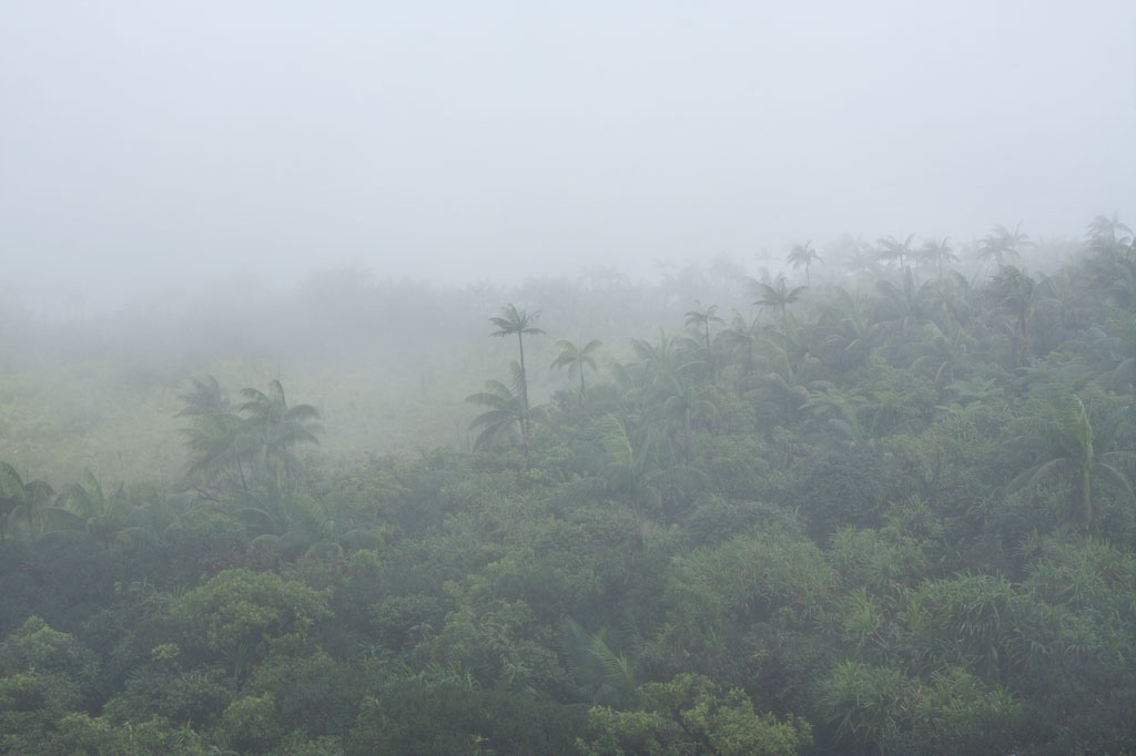
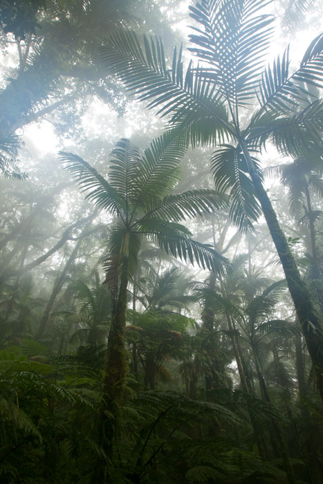
Despite the difficulty in getting to the top, the trip is well worth it. Those who have never visited a cloud forest before will be awed by the otherworldly beauty of the ridge, a perpetually dripping wonderland of stunted, hoary trees, air plants, and bryophytic growth. Virtually every surface is covered with a thick layer of spongy golden moss and the ground is composed of layer upon layer of damp, decayed matter. The area, which never dries out, gets at least 8.3 meters (325 in) of rain every year and is shrouded in thick fog much of the time, making clear views from the summit a rare occurrence.
[tabs]
[tab title=”Pehleng”]
Pehleng Approach (Western Kitti)
This well-defined trail up to the primary ridge and eventually to Nahnalaud was first promoted in 2013 by a local business calling itself Pohnpei Trailways. The idea was that this trail, starting in Pehleng, could be hiked by tourists without the assistance of a local guide. We strongly recommend that you do NOT do it that way. In fact, we think it’s a very a bad idea. Though at the time of writing (2014) the entire length of the trail was marked with pink flagging tied to tree branches, there is still plenty of potential for visitors to go astray. Furthermore, accidents or injuries without a local guide present could result in disaster. Remember that Pohnpei has no search and rescue service.
The true ascent begins after passing through a cluster of houses (ask permission) 0.95 km beyond the trailhead. After that, the trail is wide and true as it climbs steadily for 1.45 km (20% slope average) through the forest to the open fern meadow atop Dolen Salapwuk (510 m), where there are some good views in clear weather. The trail then re-enters the forest and begins to climb again for 4.6 km (13% slope average), narrowing as it comes up to the main ridge (696 m). Just before Shelter 1 (Dolmweir), there’s a 315 meter-long segment that is less than a meter wide with precipitous slopes on both sides; we’ve dubbed it the “Knife Edge.”
Shelter 1 is located at Dolmweir, where an appendage of the mountain thrusts north from the main ridge. There is no flowing water nearby. The privy is located 22 m to the north. After Shelter 1, the trail descends steeply by about 62 m on the south side of the ridge and skirts the base of a rocky cliff before climbing back to the ridge-top. From there it goes up and down for 2.94 km before reaching Mountain Shelter 2 roughly 5 minutes below the Nahnalaud summit.
- Plan for 5-7 hours from the trailhead to Shelter 1 and 3-4 hours from there to the summit.
[warning]NOTE: As of February 2014, the pandanus-thatch roofs of the two ridge shelters were in very bad shape, heavily deteriorated and leaky. Plan accordingly.[/warning]
The Origin of the Yap Banana
In the westward land of Sapani, a woman named Lienpwel (“woman of earth”) had two daughters, Lisoumokaiap and Lisoumokalang. The daughters decided to take a canoe and look for new land in the east and brought with them some “underworld yams”, banana shoots, and a stone called the Stone of Sahwar. The sisters eventually landed at a place in what is now Pwoaipwoai district (at that time the island was smaller and Pwoaipwoai lay near the coast). There they placed the stone and planted the yams. The stone was highly reflective, and when the sun would hit it, it would shine brightly (hence the name Sahwar, which means “shining” or “flashing”).
The younger of the two sisters, Lisoumokalang, eventually returned home to Sapani. On the way she visited the islands of Yap and propagated a new type of banana, which thrived and became the tallest of all banana varieties. Some time later, a Pohnpeian man who lived in a place called Loangen Kitti was looking west toward the sunset and he saw the tall banana plant in the distance. The ripe fruit were attracting many birds, so he found two starlings – one a common Micronesian starling (sioahk) and the other a Pohnpei mountain starling (sie) – and he took them up to a high mountain in Pehleng. The Micronesian starling was a lazy flier, but the mountain starling was clever and efficient. He sent both flying toward Yap. The Micronesian starling was distracted on the way and diverted from its course. Only the Pohnpei mountain starling reached its destination. It joined the other birds in eating the bananas, and while it did so, a seed became lodged in its feathers. Both birds eventually flew back to Pohnpei and landed at the peak of Pekenuht (which, appropriately, means “banana feces”). The seed carried by the mountain starling fell to the ground and propagated utin iap (the Yap banana).
[/tab]
[tab title=”Enipein Powe”]
Enipein Powe Approach (Kitti)
This route begins at the end of an unpaved road in Enipein Powe and climbs gradually on a well-defined footpath up an out-thrust from the southern ridge. At the top, the trail passes through a saddle between Nahnan Pwoaipwoai and Dolen Uhd, then descends slightly along the inside of the ridge slope, finally arriving at a massive overhanging rock known by local guides as “the cave.” The cave has nice views through the trees of the Nanmeir Valley at the Lehnmesi River source below. You can also see Nahnalaud to the northwest and make a guess at the direction of Ngihneni to the east. The cave is an excellent place to camp with a cushioned fern-lined floor (that stays dry in wet weather) and usually some dry firewood stowed by hunters in the vicinity (replace what you use).
From the cave, the trail continues along the inner slope below Ngihneni, crosses several small streams, and then climbs steeply (20% slope average) to the top of the main ridge. At this point it’s just a short walk west along the ridge path to the first open viewpoint near a USGS benchmark. The spot people typically consider to be the summit is 5-10 minutes further, and Shelter 2 is just below that.
- Plan for 6-8 hours from the trailhead to the cave and 90 minutes to 3 hours from there to the summit.
[/tab]
[tab title=”Salapwuk”]
Salapwuk Approach (Kitti)
There are many ways to Nahnalaud from Salapwuk but they all begin at the end of the road beyond Salapwuk Elementary School. The early part of the hike uses the same trail as the Six Waterfalls, but at the place where one would turn toward the river to encounter Falls #1 (Pahnairlap), one instead follows a trail going northeast. This trail stays north of the river, crossing above Iro, Nan Emp, and Lipwentiak waterfalls. The latter is the most spectacular, located where the river gets funneled into a narrow channel and makes a hairpin turn. According to legend, this feature of the river was created when the matriarch of the Great Eel Clan encountered an eel hunter and writhed violently in horror at the sight of the dead eels he was carrying. Small pools above the falls are home to Pohnpei’s endemic freshwater shrimp, which the guides might be willing to catch for dinner. After that, the trail only meets the river again twice, where it cuts through a wide loop in the watercourse. It then turns north and climbs 362 meters in elevation to the primary ridge, not far from the summit.
[/tab]
[tab title=”Nanipil”]
Nanipil Approach (Nett)
Though slightly shorter, the Nanipil approach to Nahnalaud is certainly challenging. It’s significantly steeper than the other routes (except Salapwuk) and the trail is not well-maintained once you reach the rear of the valley. The hike starts at the house next to the hydroelectric building at the end of Nanipil River Road. Immediately behind the house, hikers must cross a river and then shortly after that a small stream. An easy segment follows with a well-defined residential path leading to the last house in this part of the valley (1.39 km), where an old man lives alone.
Past the house, the route continues on a fairly well-defined path that crosses the river several times (these crossings can be tricky if there has been a lot of recent rain). In a few places, you have to walk in the river itself, which can be quite difficult given the slickness of the rocks. Finally, after 2.94 km (3% slope average), the trail begins to climb out of the valley on the east side of the river and follows a sub-ridge up from there (3.16 km with a 22% slope average).
The climb has several pitches with small, flat rest areas in between. The first stop has a conspicuous tree of gigantic proportions entwined with vines almost as massive. The second stop is frequently used as a camp site by hunters and is one of the few places on the mountain with mobile phone reception. The final segment leading to the primary ridge is steep and often muddy. In places it follows the natural pathway of small streamlets (keep an eye out for a small waterfall high up on the slope). Once reaching the main ridge (754 m elevation), it’s an easy 0.56 km walk east to Shelter 2, a typical nahs-style thatched hut that can sleep ten or so.
[warning]NOTE: As of February 2014, a large part of the roof of this shelter had rotted away, leaving the central part of the hut exposed to the elements.[/warning]
[/tab]
[tab title=”Nankepinmerepw”]
Nankepinmerepw Approach (Madolenihmw)
This route passes through the gorgeous valley of Nankepinmerepw, following the upper tributaries of the Nan Riohk Stream and eventually arriving north of Nahnalaud on an arm of the primary mountain system.
The hike begins at a rutted turn-off from the well-graded (but unpaved) road to Pahn Sile Waterfall, leads to a metal footbridge over the Senipehn River — the only bridge like it on the island — and connects with a path on the far side. From there, the trail meanders northwest not far from the Nan Riohk and more or less parallel to it.
The first kilometer or so cuts through cultivated lands. Then it begins to follow the water more closely as it passes into the wilder riverine forests. There are at least nine major stream crossings in this next segment, some of which may be difficult or impossible if there has been a lot of recent rain. Above the last major Nan Riohk tributary, where the name of the stream changes to Nankepinmerepw, hikers take to the stream bed itself, which is certainly the most challenging aspect of the route (13% slope average). The algae-slimed rocks are slick and dangerous and hikers may find that they have to go very slow and use both hands to avoid disastrous slips; it would be easy to snap an ankle or shatter a kneecap in this place. Despite the rough terrain, the scenery in this narrow valley, often fenced on both sides by high rocky walls, is terrific. At times, the trail passes along the tops of vertical prismatic basalt columns.
The first few points of interest are beautiful pools that will tempt any overheated hiker — and why resist? A bit further is a small waterfall near a prismatic basalt quarry site for Nan Madol. Abandoned prisms can be found lying in the stream bed in several places — the largest just below the falls. How exactly prisms were hauled down to the coast from this site is anyone’s guess. After a short, steep section (22% slope average), the valley terminates at a huge “horsetail” waterfall that the route crosses above (you can scramble down the eastern slope without too much difficulty for a better view from the side). The shallow pools above the falls are also an excellent place for a look at Pohnpei’s native crayfish.
Past the big waterfall, the stream narrows until it reaches a third waterfall — this one short and wide, falling over a straight lip (usually called a “block falls” or “sheet falls”) — and then diminishes to a trickle. From this point, the hike climbs west (29% slope average) and then south again as it follows the ridgeline (18% slope average) toward the Nahnalaud summit.
[/tab]
[/tabs]
How Long Will It Take?
Though it is possible to hike up and down Nahnalaud in one day, as we did during one of the many data-gathering excursions, we don’t recommend that you put yourself through that kind of torture. Hiking to Nahnalaud should be considered a 2-day affair with one night spent either at the cave, one of the mountain shelters, or somewhere else on the ridge. Inexperienced or out-of-shape hikers may need three days or more.
Hiring a Local Guide
All of the routes up to Nahnalaud require an experienced local guide.
You should offer your guide no less than $160 if there are five or less in your group and at least $220 if there are more than five (plus tips). If you do the math, you’ll see that this is quite reasonable. With five people, each hiker pays just $32 plus tips — a super bargain. If you can’t assemble a group, you’ll still only pay $80 per person with two hikers, which is less than you’d pay for two dives at virtually any SCUBA company in the world (and this is two days and one night). Obviously, if you plan to take a slower pace and do the hike over three or more days, you’ll need to pay your guide more.
Your guide is your lifeline; you will depend on him to keep you safe and on the right track throughout the duration of your hike. Guides provide other useful services as well, such as making campfires in damp weather. If you expect your guide to cook meals for the group or carry any gear for you, he should be paid extra. Agree on a price beforehand.
- Please visit the Local Guides & Tour Operators page for a list of experienced guides available for hikes to Nahnalaud.