
Temwen Vicinity GPS Data
Downloadable GPS Data Files
The following files contain all the packaged GPS data for each of the featured locations in the Temwen Vicinity Eco-Adventure Map Guide.
Three file types are provided. KMZ and KML files are compatible with Google Earth. KML is compatible with Google Maps. GPX files can be imported into ArcGIS (a professional mapping application) and some hand-held GPS devices.
[info]NOTE: All files are free to the public and can be used for any purpose without permission.[/info]
Temwen Island Coastline (2015)
- Temwen Coastline (2015) – temwen-island.kmz (36 kb)
- Temwen Coastline (2015) – temwen-island.gpx (143 kb)
Temwen Island Mangroves (2015)
- Temwen Mangroves (2015) – temwen-mangroves.kmz (298 kb)
- Temwen Mangroves (2015) – temwen-mangroves.gpx (1.3 mb)
Temwen Island Contour Lines (2015)
- Temwen Island Contour Lines (2015) – temwen-contour.kmz (21 kb)
- Temwen Island Contour Lines (2015) – temwen-contour.gpx (78 kb)
Temwen Island Roads (2015)
- Temwen Island Roads (2015) – temwen-roads.kmz (8 kb)
- Temwen Island Roads (2015) – temwen-roads.gpx (24 kb)
Temwen Island Trails & Routes (2015)
- Temwen Island Trails & Routes (2015) – temwen-routes.kmz (13 kb)
- Temwen Island Trails & Routes (2015) – temwen-routes.gpx (49 kb)
Temwen Island Points of Interest (2015)
- Temwen Island Points of Interest (2015) – temwen-places.kmz (33 kb)
- Temwen Island Points of Interest (2015) – temwen-places.gpx (118 kb)
Dolopwuropwur Gun Battery (2015)
Coordinates
The following coordinates correspond with sites featured on the Temwen Vicinity Eco-Adventure Map Guide. It is our dream to eventually create a Pohnpei GPS app that could be uploaded to smartphones and other devices, but for now, these points of interest can be entered manually in a hand-held GPS device as needed.
[info]NOTE: All GPS devices have a margin of error. That margin increases with interference — when there is a thick canopy of trees, during bad weather, or when mountains obstruct the satellite link. The geosynchronous satellites employed when navigating on Pohnpei are located low on the southwestern horizon, such that maintaining a strong connection while hiking on the northeast side of a given mountain range can be difficult. Coordinates on the northeastern slopes of mountains are less accurate than in other locations.[/info]
Temwen Island
| Temwen Causeway South Bridge | —- | 6.843731° 158.313411° |
| Temwen Causeway North Bridge | —- | 6.845294° 158.314911° |
| Peipas Island (Approx. location) | —- | 6.848979° 158.315855° |
| Salong Point | —- | 6.856344° 158.322675° |
| Temwen Elementary School | —- | 6.851509° 158.329239° |
| Current Nahnmwarki’s Residence | —- | 6.851064° 158.332056° |
| Japanese Wharf | —- | 6.855733° 158.332092° |
| Turn-Off to Nan Madol Trail | —- | 6.846941° 158.328562° |
| Nan Madol Trail Parking | —- | 6.845865° 158.330689° |
| Nan Madol Trailhead | —- | 6.844408° 158.330671° |
| End of Temwen Road / Beginning of Footpath | —- | 6.846342° 158.319744° |
| Causeway Store | —- | 6.845268° 158.314783° |
Nan Madol Ruins
| Nan Madol Trailhead | —- | 6.844408° 158.330671° |
| Peinkitel Perimeter Wall North Corner | —- | 6.844326° 158.331118° |
| Peinkitel Entrance | —- | 6.844018° 158.330501° |
| Peinkitel Tomb | —- | 6.844041° 158.330894° |
| Central Peidoh Islet | —- | 6.844092° 158.331846° |
| Sapwohng Islet West Corner | —- | 6.843660° 158.332228° |
| Huge Tree | —- | 6.843828° 158.333042° |
| Central Peilapalap Islet | —- | 6.842964° 158.332899° |
| Central Rasalap Islet | —- | 6.843384° 158.333474° |
| Central Pahseid Islet | —- | 6.843888° 158.333827° |
| Central Usendau Islet | —- | 6.844284° 158.334102° |
| Central Dau Islet | —- | 6.844609° 158.335067° |
| Nan Douwas Islet Entrance | —- | 6.844533° 158.335524° |
| Nan Douwas Islet Sakau Stones | —- | 6.844560° 158.335479° |
| Nan Douwas Islet Sakau Stone | —- | 6.844547° 158.335663° |
| Nan Douwas Islet Central Tomb | —- | 6.844535° 158.335799° |
| Nan Douwas Islet North Tomb | —- | 6.844698° 158.335777° |
| Nan Douwas Islet South Tomb | —- | 6.844390° 158.335724° |
| Central Pohn Douwas Islet | —- | 6.845042° 158.335810° |
| Central Kohnderek Islet | —- | 6.845558° 158.335205° |
| Central Pwalahng Islet | —- | 6.845051° 158.334678° |
| Kahnimweiso Gate (approx.) | —- | 6.843599° 158.337261° |
| Nan Mwoluhsei Sea-wall Entrance | —- | 6.844190° 158.336966° |
| Central Peikapw Sapwawas Islet | —- | 6.843553° 158.334780° |
| Central Pwilak Islet | —- | 6.843159° 158.333909° |
| Central Peinior Islet | —- | 6.842824° 158.334263° |
| Peinering Islet Entrance | —- | 6.842123° 158.333784° |
| Central Perektuhke Islet | —- | 6.841853° 158.332661° |
| Central Pahn Katau Islet | —- | 6.841491° 158.332450° |
| Central Dapahu Islet | —- | 6.842452° 158.332358° |
| Central Usennamw Islet | —- | 6.842585° 158.331411° |
| Central Peitaup Islet | —- | 6.841846° 158.331174° |
| Central Dekehtik Islet | —- | 6.841530° 158.331148° |
| Dorong Islet Perimeter Wall North Corner | —- | 6.840986° 158.329394° |
| Lehnkei (Pool) | —- | 6.840853° 158.331381° |
| Central Peikapw Islet | —- | 6.841907° 158.330170° |
| Idehd Islet Northwest Entrance | —- | 6.841308° 158.330293° |
| Dolen Idehd / Midden | —- | 6.841081° 158.330336° |
| Nan Samwol’s Hole, Idehd | —- | 6.841252° 158.330532° |
| Idehd Islet Northeast Entrance | —- | 6.841288° 158.330555° |
| Isokelekel’s Slingstones, Idehd | —- | 6.841194° 158.330428° |
| Pahn Kadira Islet Sokehs Corner | —- | 6.841195° 158.329971° |
| Pahn Kadira Islet Katau Corner | —- | 6.840766° 158.329374° |
| Pahn Kadira Islet House Foundation | —- | 6.840986° 158.329394° |
| Temple of Nankieilmwahu, Pahn Kadira | —- | 6.841427° 158.329366° |
| Saudeleur’s House Foundation, Pahn Kadira | —- | 6.841484° 158.328948° |
| Pahn Kadira Islet Southwest Entrance | —- | 6.841074° 158.329119° |
| Pahn Kadira Islet Sakau Stone | —- | 6.841186° 158.329195° |
| Pahn Kadira Islet Sakau Stone | —- | 6.841220° 158.329145° |
| Pahn Kadira Islet Sakau Stone | —- | 6.841266° 158.329161° |
| Pahn Kadira Islet Sakau Stone | —- | 6.841305° 158.329112° |
| Pahn Kadira Islet Sakau Stone | —- | 6.841333° 158.329119° |
| Pahn Kadira Islet Madolenihmw (Likapwar) Corner | —- | 6.841558° 158.328740° |
| Pahn Kadira Islet Kitti Corner | —- | 6.842035° 158.329364° |
| Saudeleur’s Bathing Area, Pahn Kadira | —- | 6.841207° 158.329844° |
| Central Pahn Kadira Islet Annex | —- | 6.841268° 158.328655° |
| Central Wasao Islet | —- | 6.841982° 158.328645° |
| Central Reitik Islet | —- | 6.841565° 158.328299° |
| Central Peilam Islet | —- | 6.840527° 158.328599° |
| Central Kelepwel Islet | —- | 6.840592° 158.329081° |
| Central Peinmwek Islet | —- | 6.840670° 158.329624° |
| Central Palakapw Islet | —- | 6.840433° 158.330480° |
| Central Pohnkeimw Islet | —- | 6.840469° 158.326021° |
| Mweiden Kitti (Opening) | —- | 6.839358° 158.327282° |
| Central Pahnmweid Islet | —- | 6.839566° 158.326991° |
| Central Mweid Islet | —- | 6.838856° 158.327817° |
| Boulder Wall, Pahnwi Islet | —- | 6.837491° 158.328793° |
| Upper Pahnwi Islet | —- | 6.838243° 158.329723° |
| Mweiden Weliwel (Opening) | —- | 6.838459° 158.330260° |
| Kepinehd Islet | —- | 6.838917° 158.330884° |
| Mweiden Nahnsapwe (Opening) | —- | 6.839264° 158.331517° |
| Pikalap Islet | —- | 6.839387° 158.331645° |
| Mweidalap (Opening) | —- | 6.839462° 158.331846° |
| Lemensai Islet | —- | 6.839657° 158.331986° |
| Namwenkau (Pool) | —- | 6.839964° 158.332334° |
| Central Lemenkau Islet & Sakau Stones | —- | 6.840380° 158.332956° |
| Lemenkau Islet West Entrance | —- | 6.840332° 158.332482° |
| Pahn Mwasangapw Burial Chamber | —- | 6.841272° 158.334303° |
| Angeir Burial Chamber | —- | 6.841597° 158.334853° |
| Sapwuhtik Burial Chamber | —- | 6.841978° 158.335596° |
| Lukepen Kerian | —- | 6.842601° 158.336477° |
| Kerian Islet Southwest Entrance | —- | 6.842727° 158.336632° |
| Kerian Islet Central Tomb | —- | 6.842821° 158.336771° |
| Kerian Islet North Tomb | —- | 6.842859° 158.336748° |
| Kerian Islet South Tomb | —- | 6.842776° 158.336799° |
| Barge Wreck, Kerian | —- | 6.842461° 158.336651° |
| Huge Sakau Stone, Kerian | —- | 6.842687° 158.336623° |
Dolopwuropwur Battery
| Turn-off to Dolopwuropwur Trailhead | —- | 6.850746° 158.329126° |
| Dolopwuropwur Trailhead | —- | 6.848025° 158.325991° |
| 15 cm Gun #1 | —- | 6.849032° 158.325672° |
| 15 cm Gun #2 | —- | 6.848915° 158.325796° |
| 15 cm Gun #3 | —- | 6.848777° 158.325841° |
| 15 cm Gun #4 | —- | 6.848569° 158.325807° |
| Northern Ammunition Magazine | —- | 6.848901° 158.325669° |
| Southern Ammunition Magazine | —- | 6.848668° 158.325755° |
| Unknown Japanese Foundation | —- | 6.848775° 158.325632° |
| Stone Tower Steps | —- | 6.848635° 158.325571° |
| Japanese Stone Tower | —- | 6.848609° 158.325540° |
| Dug-Out | —- | 6.848583° 158.325497° |
| Japanese Trench North End | —- | 6.848767° 158.325589° |
| Japanese Trench Intersection | —- | 6.848156° 158.324919° |
| Unknown Japanese Structure | —- | 6.848138° 158.325148° |
| Japanese Trench South End / Path Intersection | —- | 6.847964° 158.323712° |
| Cross Island Footpath South End | —- | 6.846107° 158.322737° |
| Cross Island Footpath North End | —- | 6.851214° 158.325296° |
| Dolopwuropwur Peak | —- | 6.848742° 158.325911° |
Around Temwen
| Pohnpei Agriculture & Trade School (PATS) | —- | 6.843103° 158.307976° |
| Marine Environmental Research Institute of Pohnpei (MERIP) | —- | 6.843932° 158.308811° |
| MERIP Apartments | —- | 6.843340° 158.308811° |
| Mwudoketik Island | —- | 6.841213° 158.319636° |
| Mwudokalap Island | —- | 6.839816° 158.317841° |
| Ulidei Island | —- | 6.841085° 158.316101° |
| Dauen Moahk (Channel) West End | —- | 6.845671° 158.314698° |
| Dauen Moahk (Channel) East End | —- | 6.840842° 158.328417° |
| Namwen Nahnningi Stingray Reserve | —- | 6.833504° 158.322414° |
| Nahnningi Island | —- | 6.831781° 158.326057° |
| Mall Island | —- | 6.829152° 158.322269° |
| Nahnningi Snorkeling Pool | —- | 6.828426° 158.326448° |
| Nahnningi Dive Site | —- | 6.826786° 158.324659° |
| Straight Wall Dive Site | —- | 6.832236° 158.334271° |
| Pahn Nahkapw Bridge Dive Site | —- | 6.840180° 158.342650° |
| Kepidauen Nahkapw (Reef Passage) | —- | 6.840793° 158.342252° |
| Nahkapw Island | —- | 6.843777° 158.344200° |
| Pahn Nahkapw Wall Dive Site & Snorkeling | —- | 6.843689° 158.342220° |
| Nipaden Nahkapw Snorkeling Spot | —- | 6.846010° 158.346045° |
| Dekehtik Island | —- | 6.848340° 158.348134° |
| Dekehtik Island Snorkeling Spot | —- | 6.847929° 158.346902° |
| Namwen Na Stingray Reserve | —- | 6.853543° 158.352856° |
| Na North Coast Camping, Swimming & Snorkeling | —- | 6.852748° 158.356608° |
| Nahpali Island | —- | 6.861427° 158.355330° |
| Dekehmwahu Island | —- | 6.860339° 158.359588° |
| Nahpali Island Snorkeling | —- | 6.860600° 158.353214° |
| Nahpali Island Searchlight Drum | —- | 6.862617° 158.356630° |
| Nahpali Island Gun Station #3 | —- | 6.862775° 158.356153° |
| Nahpali Island Gun Station #2 | —- | 6.862848° 158.355992° |
| Nahpali Island Gun Station #1 | —- | 6.862914° 158.355861° |
| Nahpali Island Japanes Coastal Foundation | —- | 6.862591° 158.355395° |
| Nahpali Island Beach | —- | 6.862192° 158.354946° |
| Nahpali Island Beach | —- | 6.863028° 158.355964° |
| Nahpali Island Japanese Coastal Foundation | —- | 6.862075° 158.354758° |
| Nahpali Island Japanese Diesel Engine | —- | 6.861961° 158.354814° |
| Nahpali Island Japanese Foundations | —- | 6.861690° 158.354699° |
| Nahpali Island Japanese Foundation | —- | 6.861393° 158.354617° |
| Nahpali Island Japanese Water Tank | —- | 6.861250° 158.354561° |
| Nahpali Island Japanese Coastal Water Tank | —- | 6.861402° 158.354411° |
| Nahpali Island Gateway Tree | —- | 6.861229° 158.354377° |
| Nahpali Island Japanese Cistern | —- | 6.861601° 158.354808° |
| Dekehmwahu Beach | —- | 6.861424° 158.359777° |
| Na Dive Site | —- | 6.846678° 158.365113° |
| Nanwap Corner Dive Site | —- | 6.871079° 158.356093° |
| Kepidauen Deleur (Reef Passage) | —- | 6.863361° 158.343756° |
| Madolenihmw Bay | —- | 6.861248° 158.306274° |
| Nahpali Surf Break | —- | 6.867134° 158.361762° |
| Nan Madol (Kepidauen Nahkapw) Surf Break | —- | 6.839137° 158.340387° |
Dolopwuropwur Gun Battery
![]()
![]()
![]()
![]()
![]()
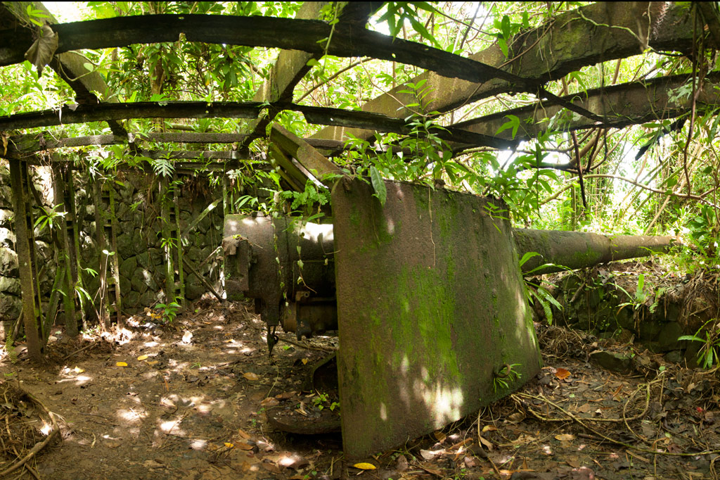
The most extensive Japanese gun battery on Pohnpei lies on Temwen’s rounded central hill, Nindol, perched at its 60 meter peak, Dolopwuropwur.
Gun Stations
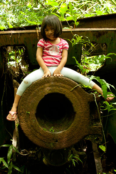
The four guns at the summit are identical to the one on Sokehs Mountain — British-made 15 cm Armstrong Whitworth naval canons manufactured in 1905. The guns are arranged in pairs with a concrete ammunition magazine between each set of stations. The semi-circular emplacements are constructed of concrete and local stone. There are also stone retaining walls along the corridors that lead to the stations. Steel girders running over Stations 1 and 4 are evidence that these two guns, at the very least, were covered to make them difficult to identify from the air. All of the stations are in relatively good condition, though the embankment around Station 3 has slipped down and partially buried the walls. Guns 1 and 4 point north and southeast, respectively, while Guns 2 and 3 point northeast. In combination, they would have had firing coverage of around 250 degrees. At the time of operation the hill was probably relatively clear of trees, providing an unobstructed view of the area islands and the two possible points of entry into the lagoon at Kepidauen Deleur and Kepidauen Nahkapw.
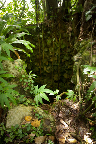
Stone Tower
West of Station 4 is a stone tower (possibly a look-out for targeting or even a searchlight emplacement). Presumably, the tower was crowned with a platform of wood or metal, but that is no longer present. Now a flight of twenty-odd steps lead to the edge of a gaping hole as deep as the tower is high. We didn’t find a searchlight, but it may lie hidden somewhere in the surrounding area.
Trench Network
A narrow 0.27 km-long (0.17 mi) trench begins at the tower base and meanders down the hill with short deviations going to a dug-out under the tower itself and a magazine-like structure built into the hillside and currently occupied by a colony of small insectivorous bats. The latter is almost large enough to park a jeep inside, but there’s no evidence of a road leading to it. It was probably additional storage for munitions. It’s possible to climb down into the trench and follow it until it connects with one of the well-trodden footpaths in the Temwen interior.
The 0.3 km (0.19 mi) trail to the battery begins not far from the end of a muddy residential road opposite Temwen Elementary School and can be easily followed without a guide.
The family at the last house on the road charges $3.00 per person to visit Dolopwuropwur.
- Plan for 1-2 hours to fully explore the area and 1 hour (each way) for the drive.