
(Central) Madolenihmw GPS Data
Downloadable GPS Data Files
The following files contain all the packaged GPS data for each of the featured locations in the (Central) Madolenihmw Eco-Adventure Map Guide.
Three file types are provided. KMZ and KML files are compatible with Google Earth. KML is compatible with Google Maps. GPX files can be imported into ArcGIS (a professional mapping application) and some hand-held GPS devices.
[info]NOTE: All files are free to the public and can be used for any purpose without permission.[/info]
Dolen Merewi Hike (2015)
Madolenihmw Bay Area Attractions (2015)
Nankep Waterfall Hike (2015)
Pahnsapw Waterfalls Hike (2015)
Pahn Sile Waterfall Hike (2015)
Pohnpaip Petroglyphs (2015)
Coordinates
The following coordinates correspond with sites featured on the (Central) Madolenihmw Eco-Adventure Map Guide. It is our dream to eventually create a Pohnpei GPS app that could be uploaded to smartphones and other devices, but for now, these points of interest can be entered manually in a hand-held GPS device as needed.
[info]NOTE: All GPS devices have a margin of error. That margin increases with interference — when there is a thick canopy of trees, during bad weather, or when mountains obstruct the satellite link. The geosynchronous satellites employed when navigating on Pohnpei are located low on the southwestern horizon, such that maintaining a strong connection while hiking on the northeast side of a given mountain range can be difficult. Coordinates on the northeastern slopes of mountains are less accurate than in other locations.[/info]
Dolen Merewi
| Dolen Merewi Turn-Off | —- | 6.882208° 158.290005° |
| Road Branching – bear left | —- | 6.881983° 158.278225° |
| Dolen Merewi Trailhead | —- | 6.880292° 158.274669° |
| Private Residence | —- | 6.880442° 158.274156° |
| Look-Out Point | —- | 6.883006° 158.270929° |
| Dolen Merewi True Summit | —- | 6.882815° 158.270869° |
Madolenihmw Bay Area
| Lukop, Metipw & Kepine Turn-Off | —- | 6.898141° 158.315994° |
| Road Branching – bear left for Lukop and Metipw; bear right for Kepine and Takaiuh | —- | 6.889728° 158.314120° |
| Bridge | —- | 6.884719° 158.313625° |
| Japanese Agricultural Plots | —- | 6.886711° 158.311515° |
| Nanpahlap Trailhead | —- | 6.876366° 158.318225° |
| Nanpahlap Summit | —- | 6.875491° 158.315744° |
| Tahio Trailhead | —- | 6.874010° 158.317018° |
| Japanese Dug-Out | —- | 6.873007° 158.316122° |
| Japanese Trench | —- | 6.872754° 158.315133° |
| Japanese Tunnel | —- | 6.873264° 158.314119° |
| Abandoned Community Hut (nahs) | —- | 6.872849° 158.314316° |
| Takaiuh Summit | —- | 6.872128° 158.310713° |
| Rocky Hill | —- | 6.874429° 158.308532° |
| Dauen Sapwalap Entrance | —- | 6.876938° 158.308196° |
| Japanese Rice Paddies Turn-Off | —- | 6.888314° 158.296764° |
| Japanese Rice Paddies & Irrigation Canals | —- | 6.887325° 158.303652° |
| Metipw Causeway / Launch | —- | 6.878051° 158.333074° |
| Mwudokolos Island | —- | 6.883576° 158.336525° |
| Dahu Reirei Island | —- | 6.888759° 158.344288° |
| “Channel Island” | —- | 6.899494° 158.342153° |
| Nanwap Marine Protected Area | —- | 6.872988° 158.353673° |
| Nahpali Island Dock | —- | 6.861877° 158.354457° |
| Salong Point, Temwen Island | —- | 6.856468° 158.322737° |
| MERIP Boathouse | —- | 6.844010° 158.308539° |
| Madolenihmw Ice Dock | —- | 6.849520° 158.302712° |
| Madolenihmw Bay Scenic Point | —- | 6.855273° 158.295686° |
Nankep Waterfall
| Nankep Waterfall Turn-Off | —- | 6.858738° 158.291440° |
| Bridge | —- | 6.858789° 158.291453° |
| Nankep Waterfall Trailhead | —- | 6.859867° 158.286390° |
| Nankep Waterfall | —- | 6.859335° 158.283177° |
Nankepinmerepw Valley
| Nankepinmerepw Turn-Off | —- | 6.873704° 158.286552° |
| Nankepinmerepw Trailhead | —- | 6.875185° 158.273305° |
| Senipehn Footbridge | —- | 6.876110° 158.271732° |
| Private Residence | —- | 6.877294° 158.263737° |
| Small Falls & Swimming Pool | —- | 6.877911° 158.242150° |
| Prismatic Basalt Quarry Site / Falls | —- | 6.878689° 158.240613° |
| Nankepinmerepw Waterfall | —- | 6.880498° 158.239370° |
| Block Waterfall | —- | 6.882766° 158.238850° |
| Trail Branching – bear right for Nahnalaud; bear left for “The Cave.” | —- | 6.888859° 158.288880° |
| “The Cave” | —- | 6.866427° 158.230917° |
| USGS Benchmark | —- | 6.874333° 158.230076° |
| Nahnalaud Look-Out Point #2 | —- | 6.874333° 158.230076° |
| Nahnalaud Look-Out Point #1 / Observed Summit | —- | 6.873876° 158.228524° |
| Nahnalaud True Summit | —- | 6.873323° 158.228724° |
| Nahnalaud Mountain Shelter | —- | 6.874001° 158.227374° |
Pahnsapw Waterfalls
| Pahnsapw Waterfall Turn-Off | —- | 6.871427° 158.285654° |
| Sakau Market | —- | 6.871839° 158.285500° |
| Sakau Market | —- | 6.871234° 158.285637° |
| Road Branching – bear right | —- | 6.870202° 158.282381° |
| Bridge | —- | 6.870052° 158.280071° |
| Road Branching – bear right | —- | 6.870060° 158.280108° |
| Road Branching – bear left | —- | 6.869425° 158.278666° |
| Pahnsapw Trailhead | —- | 6.868207° 158.278527° |
| Silbanuz Residence | —- | 6.867969° 158.278513° |
| Pahnsapw Lower Falls | —- | 6.865171° 158.277289° |
| Hidden Pool | —- | 6.865183° 158.277071° |
| Pahnsapw Upper Falls | —- | 6.864683° 158.277100° |
Pahn Sile Waterfall
| Pahn Sile Waterfall Turn-Off | —- | 6.873704° 158.286552° |
| Taxi Stop | —- | 6.873691° 158.286771° |
| Bridge | —- | 6.873629° 158.286431° |
| Road Branching – bear left | —- | 6.875588° 158.281340° |
| Road Branching – bear left | —- | 6.875802° 158.276411° |
| Road Branching – bear left | —- | 6.875179° 158.273294° |
| Pahn Sile Trailhead | —- | 6.873597° 158.269375° |
| Trail Branching – bear right | —- | 6.873598° 158.269382° |
| Trail Branching – bear left | —- | 6.873662° 158.269032° |
| Japanese Irrigation Canal | —- | 6.871403° 158.266674° |
| Japanese Irrigation Canal | —- | 6.870612° 158.265405° |
| Stream Crossing | —- | 6.866702° 158.264493° |
| Trail Branching – Bear right for waterfall & pool; left to see the falls from above | —- | 6.866048° 158.264342° |
| Senipehn River Crossing | —- | 6.865499° 158.263650° |
| Pahn Sile Waterfall Pool | —- | 6.864499° 158.263151° |
| Pahn Sile Waterfall | —- | 6.864467° 158.263028° |
| Break north From trail to see the falls from above | —- | 6.864209° 158.262860° |
Pohnpaip Petroglyphs
| Pohnpaip Petroglyphs Turn-Off | —- | 6.886941° 158.291017° |
| Bridge | —- | 6.886789° 158.290910° |
| Pohnpaip Trailhead | —- | 6.888161° 158.289097° |
| Herson Residence | —- | 6.887435° 158.288495° |
| Pohnpaip Outcropping | —- | 6.887621° 158.288259° |
| Magical Door of Pohnpaip | —- | 6.887551° 158.288181° |
| Takain Pahsu | —- | 6.888396° 158.288694° |
| “Hindquarters Rock” | —- | 6.888665° 158.288933° |
| “Enveloped Cross Rock” | —- | 6.888859° 158.288880° |
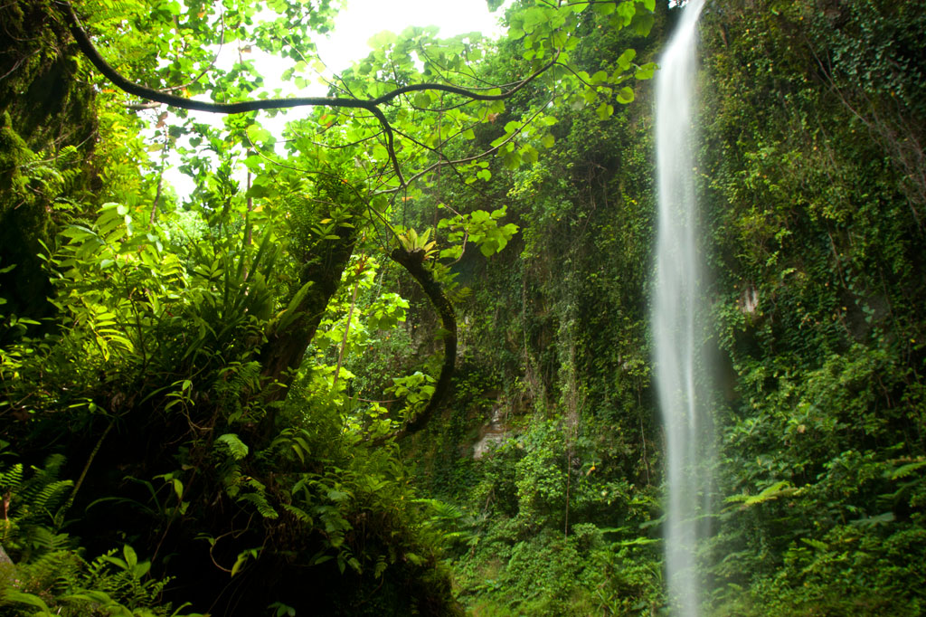
Pahnsapw & Nankep Waterfalls
![]()
![]()
![]()
![]()
![]()
")
Pahnsapw, which means “beneath the land,” refers to a pair of tall, majestic waterfalls which plummet off the edge of a high plateau in central Madolenihmw (it’s also the name of the farmstead). Both waterfalls are found on the land of the Silbanuz family (relatives of the people at the Nan Madol trailhead) — the smaller falls is lower down and hidden from view until you get up-stream, but the upper falls can be seen from the Circle Island Road.
The hike starts at the end of an unpaved road and criss-crosses the stream or runs along the bank up to the first falls, which is about 4 to 6 meters (13-20 ft) high and has a beautiful shallow pool at the base, excellent for a quick, cool swim. Unless you’re in good physical condition and don’t mind getting dirty, this is where you should stop.
")
To reach the second falls, the route climbs straight up an extremely steep (and sometimes muddy) slope to the right of the lower waterfall with little to hold on to, turns horizontally across the slope face, and then returns to the river, where there’s a secluded pool in a shady nook. It might be a good idea to bring a length of rope and have the guide secure it to something at the top of the slope prior to scrambling up. Five minutes up-stream is the second waterfall, which is about 18 meters (60 ft) tall and falls into a large, deep pool. The water at both waterfalls is cool and very clean.
The Silbanuz family charges an access fee of $2.00 per person. Any of the teenagers around the house can be hired as guides. Offer $12.00.
- Plan for 2 hours round-trip with some leisure time at both of the waterfall pools.
Nankep Waterfall
The next waterfall going south is known as Nankep. People living in the area say the name means “inlet” or “in the cup” (depending on who you talk to). The latter seems logical, except that the Pohnpeian word kep is a loaner from English and wouldn’t date back beyond the early 1800s. The site may have had a different name prior to that time or it has picked up new meaning over the years. The road to this trailhead is steeper and more rutted than the one to Pahnsapw, so it’s best to park at the bottom near the Circle Island Road and walk to the end, where the trail begins on Waltis Herdinand’s land — an area referred to as Elilpei. The hike is short and relatively easy, concluding in a hidden nook with a small plunge pool. The best time to visit Nankep is after a period of heavy rain as it can be nothing more than a tiny ribbon of water at other times. Some people believe that the falls will be dry if all the members of the visiting group are male, so mix it up.
No official access fee is charged.
- Plan for 90 minutes round-trip with time to swim at the falls.
- To hire a guide, ask at the houses in the area, contact Hanke Albert at +691.320.4047, or call the owner of the land around the falls, Waltis Herdinand, at +691.320.2909. Offer $12.00.