
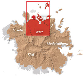
Nett & Western U GPS Data
Downloadable GPS Data Files
The following files contain all the packaged GPS data for each of the featured locations in Greater Nett & Western U.
Three file types are provided. KMZ and KML files are compatible with Google Earth. KML is compatible with Google Maps. GPX files can be imported into ArcGIS (a professional mapping application) and some hand-held GPS devices.
[info]NOTE: All files are free to the public and can be used for any purpose without permission.[/info]
Marine Parks in Awak Pah (2015)
Dolen Eirike (2015)
Dolen Nahnsapwe (2015)
Lou Rahn Cave & Waterfall (2015)
Nan Kiepw & Na Malek Cave (2015)
Nan Koropwung Cliff, Waterfall & Caverns (2015)
Dolen Nett / Pohnlehr (2015)
Nanipil Vicinity (2015)
These files include Liduduhniap, Sengnaip, Likei, Pahn Pwet, and Nan Kiepw waterfalls, the Nanipil Bird Walk, the Swimming Pond, and another popular swimming hole in the area.
Coordinates
The following coordinates correspond with sites featured on the Greater Nett & Western u Eco-Adventure Map Guide. It is our dream to eventually create a Pohnpei GPS app that could be uploaded to smartphones and other devices, but for now, these points of interest can be entered manually in a hand-held GPS device as needed.
[info]NOTE: All GPS devices have a margin of error. That margin increases with interference — when there is a thick canopy of trees, during bad weather, or when mountains obstruct the satellite link. The geosynchronous satellites employed when navigating on Pohnpei are located low on the southwestern horizon, such that maintaining a strong connection while hiking on the northeast side of a given mountain range can be difficult. Coordinates on the northeastern slopes of mountains are less accurate than in other locations.[/info]
Awak Marine Parks
| Awak Pah MP Entrance | —- | 6.965910° 158.250758° |
| Pein Ahi Entrance | —- | 6.966711° 158.251138° |
| Paieke Entrance | —- | 6.969853° 158.256294° |
| Awak Pah MP Dock | —- | 6.966470° 158.248785° |
| Pein Ahi Fish Pond | —- | 6.967572° 158.249929° |
Dolen Eirike
| Relio Lengsi’s Residence | —- | 6.926688° 158.227910° |
| Dolen Eirike Trailhead | —- | 6.919570° 158.227397° |
| Sakau Plantation | —- | 6.917106° 158.227410° |
| Japanese Trench Network | —- | 6.915589° 158.230300° |
| Dolen Eirike Summit | —- | 6.915140° 158.231599° |
| Dol Rakied Summit | —- | 6.906234° 158.237645° |
Dolen Nahnsapwe
| Dolen Nahnsapwe Trailhead – Nett Approach | —- | 6.927169° 158.246675° |
| Dolen Nahnsapwe Trailhead – U Approach | —- | 6.918897° 158.270844° |
| Dolen Nahnsapwe Summit | —- | 6.909546° 158.260936° |
| Dolen Nahnsapwe Turn-Off from Lou Rahn Trail | —- | 6.923336° 158.249283° |
Lou Rahn
| Lou Rahn Trailhead | —- | 6.927169° 158.246675° |
| Lou Rahn Cave & Waterfall | —- | 6.918551° 158.253955° |
Nan Kiepw & Na Malek
| Nan Kiepw / Na Malek / Nahnalaud Nett Trailhead | —- | 6.918179° 158.214601° |
| Stream Crossing | —- | 6.917458° 158.215238° |
| Nahnalaud Turn-Off from Nan Kiepw Trail | —- | 6.910792° 158.217769° |
| Last House along trail | —- | 6.900363° 158.214973° |
| Na Malek Loop Turn-Off from Nan Kiepw Trail | —- | 6.897523° 158.213266° |
| Na Malek Loop Turn-Off from Nan Kiepw Trail | —- | 6.895756° 158.213144° |
| Na Malek Cave | —- | 6.895878° 158.211765° |
| Kiepw Waterfall | —- | 6.889668° 158.211740° |
| Nan Kiepw Overhang & Campsite | —- | 6.889639° 158.211035° |
Nan Koropwung
| Nan Koropwung Trailhead | —- | 6.925729° 158.254909° |
| Cliff & Waterfall | —- | 6.927155° 158.259679° |
| Cave 1 | —- | 6.927513° 158.259859° |
| Cave 2 | —- | 6.927877° 158.259142° |
| Cave 3 | —- | 6.927884° 158.259038° |
Dolen Nett / Pohnlehr
| Dolen Nett Trailhead 1 | —- | 6.968282° 158.230457° |
| Dolen Nett Trailhead 2 | —- | 6.965640° 158.234757° |
| Dolen Nett Trailhead 3 | —- | 6.959650° 158.225124° |
| Dolen Nett Trailhead 4 | —- | 6.969614° 158.228438° |
| Japanese Tunnel Entrance | —- | 6.965840° 158.228329° |
| Yam Plantation | —- | 6.965248° 158.228609° |
| Japanese Defensive Position | —- | 6.964007° 158.229053° |
| Japanese Trench Network | —- | 6.963868° 158.229051° |
| Japanese Trench Network | —- | 6.963073° 158.229706° |
| Japanese Trench Network | —- | 6.963105° 158.229949° |
| Japanese Trench Network | —- | 6.963125° 158.230125° |
| Japanese Trench Network | —- | 6.963025° 158.230332° |
| Pandanus Grove | —- | 6.961883° 158.230662° |
| Coconut Palm Grove | —- | 6.961188° 158.231013° |
| 80 mm Field Gun | —- | 6.958862° 158.233030° |
| Rusted Barrels | —- | 6.958814° 158.233064° |
| 80 mm Gun in Bunker | —- | 6.958838° 158.233535° |
| Machinegun Bunker | —- | 6.958741° 158.233545° |
| Bunker | —- | 6.958765° 158.233415° |
| Pohnlehr Summit | —- | 6.958226° 158.233346° |
| Japanese Mobile Radar Array | —- | 6.958767° 158.232402° |
Sengnaip Waterfalls
| Trailhead | —- | 6.920677° 158.204421° |
| Route Intersection | —- | 6.920647° 158.201060° |
| Sengnaip Cave | —- | 6.917556° 158.200460° |
| Sengnaip Waterfalls | —- | 6.917522° 158.200383° |
Likei & Pahn Pwet Waterfalls
| Trailhead | —- | 6.920677° 158.204421° |
| Route Intersection | —- | 6.920647° 158.201060° |
| Stream Crossing | —- | 6.919559° 158.198878° |
| Log Crossing | —- | 6.916577° 158.198932° |
| Route Intersection | —- | 6.916577° 158.198932° |
| Route Intersection | —- | 6.914373° 158.199648° |
| Route Intersection | —- | 6.904178° 158.192649° |
| Route Intersection | —- | 6.904178° 158.192649° |
| Likei Waterfall | —- | 6.903375° 158.189810° |
| Pahn Pwet Waterfall | —- | 6.902343° 158.192313° |
Nan Kiepw Waterfall
| Trailhead | —- | 6.919873° 158.206230° |
| Route Intersection | —- | 6.914373° 158.199648° |
| Nan Kiepw Waterfall | —- | 6.897512° 158.206958° |
Liduduhniap Waterfalls
| Trailhead | —- | 6.919915° 158.206706° |
| Upper Pool | —- | 6.918893° 158.206592° |
| Upper Falls | —- | 6.918891° 158.206557° |
| Lower Pool | —- | 6.918564° 158.206676° |
| Lower Falls | —- | 6.918695° 158.206572° |
Nanipil Vicinity
| Nanipil Bird Walk Trailhead | —- | 6.920677° 158.204421° |
| Nanipil Bird Walk Trail End | —- | 6.919559° 158.198878° |
| Hydroelectric Building | —- | 6.918222° 158.214670° |
| Japanese Pump Station | —- | 6.918404° 158.214481° |
| Swimming Pond Trailhead | —- | 6.922461° 158.215089° |
| Swimming Pond | —- | 6.922642° 158.215955° |
| Cable Bridge Swimming Hole | —- | 6.932656° 158.216346° |
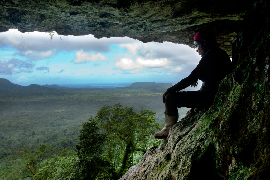
Nan Koropwung Cliff & Caverns
![]()
![]()
![]()
![]()
![]()
")
Anyone who takes a good look at the mountains on the eastern border of Nett will note a dark patch of naked basalt amid the otherwise unvarying green of the steep hillsides. This is the cliff-wall and caverns of Nan Koropwung. The trail to this spectacular and little-known site begins at the end of the unpaved but well-graded road in Paremkep and meanders up the heavily-wooded slope with some rather steep and brushy sections. Eventually, one comes to a towering wall of prismatic basalt columns overrun by a waterfall, which can be dramatic after heavy rain, but is most often thin and misty. Below the falls, the bare rock is in the process of decomposition, smooth and crumbly.
The first 164 m / 180 yd (12% slope avg) from the trailhead brings hikers to a small sakau hut in the woods. The narrow stream crosses the path 57 m (62 yd) further (16% slope avg). After that, the path fades into obscurity and it’s a challenging 489 m (0.3 mi) bush-whack scramble to the cliff and waterfall (47% slope avg). That’s not the end, however, by a long shot. If you pick your way across the rocks under the falls and along the slope for about 80 m (87 yd), you’ll come to the first cave of three. Partially hidden by a curtain of vines, this cave is well-protected from the elements and makes a good campsite. There are great views of Nett and Kolonia and some flat, dry ground.
About 130 m (142 yd) further is a second cave — this one forming a low, tunnel-like passage parallel to the hillside. Swiftlets nest on the roof and their guano covers the floor. Scramble through and you find yourself in the final cave, which is like a bay window looking out over the serene landscapes of Nett and eastern Sokehs. There’s really nothing like this spot on the island. Take care, however — the cavern opens onto a sheer (certainly fatal) drop to the valley below.
- Plan for 3-6 hours for this hike.
- Please visit the Local Guides & Tour Operators page for a list of experienced guides available for hikes to Nan Koropwung. Offer $25-37.00 for a group of five or less.