
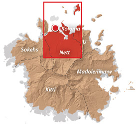
Nett & Western U GPS Data
Downloadable GPS Data Files
The following files contain all the packaged GPS data for each of the featured locations in Greater Nett & Western U.
Three file types are provided. KMZ and KML files are compatible with Google Earth. KML is compatible with Google Maps. GPX files can be imported into ArcGIS (a professional mapping application) and some hand-held GPS devices.
[info]NOTE: All files are free to the public and can be used for any purpose without permission.[/info]
Marine Parks in Awak Pah (2015)
Dolen Eirike (2015)
Dolen Nahnsapwe (2015)
Lou Rahn Cave & Waterfall (2015)
Nan Kiepw & Na Malek Cave (2015)
Nan Koropwung Cliff, Waterfall & Caverns (2015)
Dolen Nett / Pohnlehr (2015)
Nanipil Vicinity (2015)
These files include Liduduhniap, Sengnaip, Likei, Pahn Pwet, and Nan Kiepw waterfalls, the Nanipil Bird Walk, the Swimming Pond, and another popular swimming hole in the area.
Coordinates
The following coordinates correspond with sites featured on the Greater Nett & Western u Eco-Adventure Map Guide. It is our dream to eventually create a Pohnpei GPS app that could be uploaded to smartphones and other devices, but for now, these points of interest can be entered manually in a hand-held GPS device as needed.
[info]NOTE: All GPS devices have a margin of error. That margin increases with interference — when there is a thick canopy of trees, during bad weather, or when mountains obstruct the satellite link. The geosynchronous satellites employed when navigating on Pohnpei are located low on the southwestern horizon, such that maintaining a strong connection while hiking on the northeast side of a given mountain range can be difficult. Coordinates on the northeastern slopes of mountains are less accurate than in other locations.[/info]
Awak Marine Parks
| Awak Pah MP Entrance | —- | 6.965910° 158.250758° |
| Pein Ahi Entrance | —- | 6.966711° 158.251138° |
| Paieke Entrance | —- | 6.969853° 158.256294° |
| Awak Pah MP Dock | —- | 6.966470° 158.248785° |
| Pein Ahi Fish Pond | —- | 6.967572° 158.249929° |
Dolen Eirike
| Relio Lengsi’s Residence | —- | 6.926688° 158.227910° |
| Dolen Eirike Trailhead | —- | 6.919570° 158.227397° |
| Sakau Plantation | —- | 6.917106° 158.227410° |
| Japanese Trench Network | —- | 6.915589° 158.230300° |
| Dolen Eirike Summit | —- | 6.915140° 158.231599° |
| Dol Rakied Summit | —- | 6.906234° 158.237645° |
Dolen Nahnsapwe
| Dolen Nahnsapwe Trailhead – Nett Approach | —- | 6.927169° 158.246675° |
| Dolen Nahnsapwe Trailhead – U Approach | —- | 6.918897° 158.270844° |
| Dolen Nahnsapwe Summit | —- | 6.909546° 158.260936° |
| Dolen Nahnsapwe Turn-Off from Lou Rahn Trail | —- | 6.923336° 158.249283° |
Lou Rahn
| Lou Rahn Trailhead | —- | 6.927169° 158.246675° |
| Lou Rahn Cave & Waterfall | —- | 6.918551° 158.253955° |
Nan Kiepw & Na Malek
| Nan Kiepw / Na Malek / Nahnalaud Nett Trailhead | —- | 6.918179° 158.214601° |
| Stream Crossing | —- | 6.917458° 158.215238° |
| Nahnalaud Turn-Off from Nan Kiepw Trail | —- | 6.910792° 158.217769° |
| Last House along trail | —- | 6.900363° 158.214973° |
| Na Malek Loop Turn-Off from Nan Kiepw Trail | —- | 6.897523° 158.213266° |
| Na Malek Loop Turn-Off from Nan Kiepw Trail | —- | 6.895756° 158.213144° |
| Na Malek Cave | —- | 6.895878° 158.211765° |
| Kiepw Waterfall | —- | 6.889668° 158.211740° |
| Nan Kiepw Overhang & Campsite | —- | 6.889639° 158.211035° |
Nan Koropwung
| Nan Koropwung Trailhead | —- | 6.925729° 158.254909° |
| Cliff & Waterfall | —- | 6.927155° 158.259679° |
| Cave 1 | —- | 6.927513° 158.259859° |
| Cave 2 | —- | 6.927877° 158.259142° |
| Cave 3 | —- | 6.927884° 158.259038° |
Dolen Nett / Pohnlehr
| Dolen Nett Trailhead 1 | —- | 6.968282° 158.230457° |
| Dolen Nett Trailhead 2 | —- | 6.965640° 158.234757° |
| Dolen Nett Trailhead 3 | —- | 6.959650° 158.225124° |
| Dolen Nett Trailhead 4 | —- | 6.969614° 158.228438° |
| Japanese Tunnel Entrance | —- | 6.965840° 158.228329° |
| Yam Plantation | —- | 6.965248° 158.228609° |
| Japanese Defensive Position | —- | 6.964007° 158.229053° |
| Japanese Trench Network | —- | 6.963868° 158.229051° |
| Japanese Trench Network | —- | 6.963073° 158.229706° |
| Japanese Trench Network | —- | 6.963105° 158.229949° |
| Japanese Trench Network | —- | 6.963125° 158.230125° |
| Japanese Trench Network | —- | 6.963025° 158.230332° |
| Pandanus Grove | —- | 6.961883° 158.230662° |
| Coconut Palm Grove | —- | 6.961188° 158.231013° |
| 80 mm Field Gun | —- | 6.958862° 158.233030° |
| Rusted Barrels | —- | 6.958814° 158.233064° |
| 80 mm Gun in Bunker | —- | 6.958838° 158.233535° |
| Machinegun Bunker | —- | 6.958741° 158.233545° |
| Bunker | —- | 6.958765° 158.233415° |
| Pohnlehr Summit | —- | 6.958226° 158.233346° |
| Japanese Mobile Radar Array | —- | 6.958767° 158.232402° |
Sengnaip Waterfalls
| Trailhead | —- | 6.920677° 158.204421° |
| Route Intersection | —- | 6.920647° 158.201060° |
| Sengnaip Cave | —- | 6.917556° 158.200460° |
| Sengnaip Waterfalls | —- | 6.917522° 158.200383° |
Likei & Pahn Pwet Waterfalls
| Trailhead | —- | 6.920677° 158.204421° |
| Route Intersection | —- | 6.920647° 158.201060° |
| Stream Crossing | —- | 6.919559° 158.198878° |
| Log Crossing | —- | 6.916577° 158.198932° |
| Route Intersection | —- | 6.916577° 158.198932° |
| Route Intersection | —- | 6.914373° 158.199648° |
| Route Intersection | —- | 6.904178° 158.192649° |
| Route Intersection | —- | 6.904178° 158.192649° |
| Likei Waterfall | —- | 6.903375° 158.189810° |
| Pahn Pwet Waterfall | —- | 6.902343° 158.192313° |
Nan Kiepw Waterfall
| Trailhead | —- | 6.919873° 158.206230° |
| Route Intersection | —- | 6.914373° 158.199648° |
| Nan Kiepw Waterfall | —- | 6.897512° 158.206958° |
Liduduhniap Waterfalls
| Trailhead | —- | 6.919915° 158.206706° |
| Upper Pool | —- | 6.918893° 158.206592° |
| Upper Falls | —- | 6.918891° 158.206557° |
| Lower Pool | —- | 6.918564° 158.206676° |
| Lower Falls | —- | 6.918695° 158.206572° |
Nanipil Vicinity
| Nanipil Bird Walk Trailhead | —- | 6.920677° 158.204421° |
| Nanipil Bird Walk Trail End | —- | 6.919559° 158.198878° |
| Hydroelectric Building | —- | 6.918222° 158.214670° |
| Japanese Pump Station | —- | 6.918404° 158.214481° |
| Swimming Pond Trailhead | —- | 6.922461° 158.215089° |
| Swimming Pond | —- | 6.922642° 158.215955° |
| Cable Bridge Swimming Hole | —- | 6.932656° 158.216346° |
Dolen Eirike
![]()
![]()
![]()
![]()
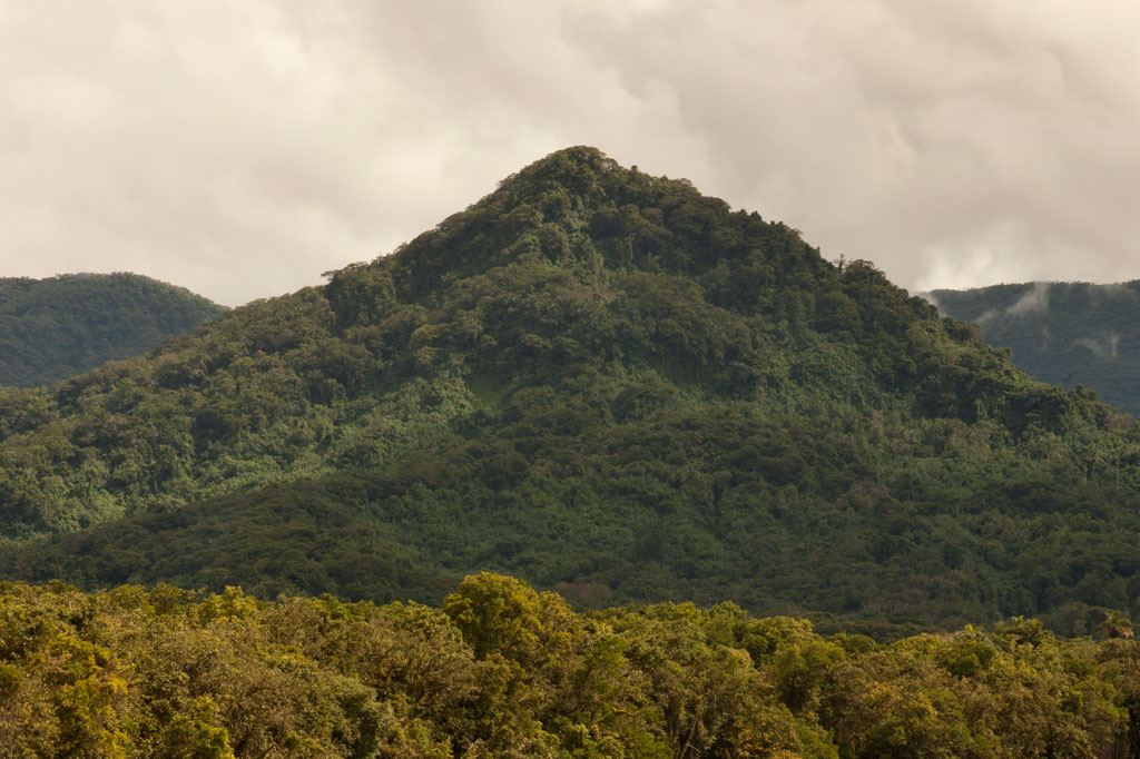
Dolen Eirike (“hill of Eirike”) is a prominent pyramid-shaped peak in Eirike district at the rear of Nett — easily visible from Kolonia and standing out from everything else as one drives south from the coast.
The ascent to the summit makes for a nice half to full-day excursion. A paved road runs through Kahmar, crosses the Pilen Kahmar bridge, and then climbs up and along a low ridge in Eirike before dipping back down again. Along the drive, you’ll pass rows of gorgeous Mindinao gums and Terminalia carolinensis trees (a species found only on Pohnpei and Kosrae) and several spots with wonderful views of the river valleys on both sides. The Eirike road, however, has some bad spots near the turn-off, so you’ll need to go slow and have a vehicle that isn’t too low to the ground.
The trailhead is located at the end of the paved road just beyond the last house and at the foot of the mountain. During the Japanese period, Catholic missionaries working in Kolonia were forceably relocated to a camp in this vicinity, though it’s not clear exactly where. Now the area is mostly small farmsteads, sakau plots, and jungle.
")
The well-trodden lower 0.28 km (0.17 mi) of the trail winds upwards through large areas of sakau cultivation with an average slope of about 23%. As you begin to move above the cultivated areas, the forest thickens and provides cover from the sun but not much relief from the stifling heat. The rest of the climb to the summit is a pretty consistent slope of about 38%. Giant tree ferns with blood-red sap, wild banana plants (utin wel), elaeocarpus, and ivory nut palms are abundant on the slopes.
Slightly less than a half kilometer from the top, you’ll pass a series of Japanese World War II trenches that cross the path. Historical records seem to indicate that anti-aircraft guns were also installed nearby, but they aren’t there now.
The summit itself is often overgrown, but you can get some nice views of Kolonia Town and Sokehs Island through the trees. There’s plenty of flat ground for a campsite and enough trees for protection against any wind.
- Plan for 4-8 hours for this hike.
- Please visit the Local Guides & Tour Operators page for a list of experienced guides available for hikes to Dolen Eirike. Offer $25-50.00 for a group of five or less.
The Story of the Tree of Nansokele
Eirike was part of the ancient region of Nansokele before the chiefdom of Nett split off from Sokehs. As is told in one famous legend, shortly after the fall of the Saudeleurs, some men were trying to cut down a large Terminalia carolinensis tree (kehma) near Dolen Eirike with the intention of building a canoe. No matter what they tried, however, the tree would not fall down. The high priest of Wene was called for and used a special adze to chop through the stubborn trunk, but instead of toppling over, the tree rose up and vanished into the clouds. Soon after, word spread that a canoe made from the wood of the same tree had descended from heaven and hovered over the ocean at a spot near Temwen Island (Sounahleng). The people took this to be a divine omen, and a great meeting followed at Poasoile on Temwen Island, where the paramount chief system that exists today was established.