
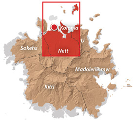
Nett & Western U GPS Data
Downloadable GPS Data Files
The following files contain all the packaged GPS data for each of the featured locations in Greater Nett & Western U.
Three file types are provided. KMZ and KML files are compatible with Google Earth. KML is compatible with Google Maps. GPX files can be imported into ArcGIS (a professional mapping application) and some hand-held GPS devices.
[info]NOTE: All files are free to the public and can be used for any purpose without permission.[/info]
Marine Parks in Awak Pah (2015)
Dolen Eirike (2015)
Dolen Nahnsapwe (2015)
Lou Rahn Cave & Waterfall (2015)
Nan Kiepw & Na Malek Cave (2015)
Nan Koropwung Cliff, Waterfall & Caverns (2015)
Dolen Nett / Pohnlehr (2015)
Nanipil Vicinity (2015)
These files include Liduduhniap, Sengnaip, Likei, Pahn Pwet, and Nan Kiepw waterfalls, the Nanipil Bird Walk, the Swimming Pond, and another popular swimming hole in the area.
Coordinates
The following coordinates correspond with sites featured on the Greater Nett & Western u Eco-Adventure Map Guide. It is our dream to eventually create a Pohnpei GPS app that could be uploaded to smartphones and other devices, but for now, these points of interest can be entered manually in a hand-held GPS device as needed.
[info]NOTE: All GPS devices have a margin of error. That margin increases with interference — when there is a thick canopy of trees, during bad weather, or when mountains obstruct the satellite link. The geosynchronous satellites employed when navigating on Pohnpei are located low on the southwestern horizon, such that maintaining a strong connection while hiking on the northeast side of a given mountain range can be difficult. Coordinates on the northeastern slopes of mountains are less accurate than in other locations.[/info]
Awak Marine Parks
| Awak Pah MP Entrance | —- | 6.965910° 158.250758° |
| Pein Ahi Entrance | —- | 6.966711° 158.251138° |
| Paieke Entrance | —- | 6.969853° 158.256294° |
| Awak Pah MP Dock | —- | 6.966470° 158.248785° |
| Pein Ahi Fish Pond | —- | 6.967572° 158.249929° |
Dolen Eirike
| Relio Lengsi’s Residence | —- | 6.926688° 158.227910° |
| Dolen Eirike Trailhead | —- | 6.919570° 158.227397° |
| Sakau Plantation | —- | 6.917106° 158.227410° |
| Japanese Trench Network | —- | 6.915589° 158.230300° |
| Dolen Eirike Summit | —- | 6.915140° 158.231599° |
| Dol Rakied Summit | —- | 6.906234° 158.237645° |
Dolen Nahnsapwe
| Dolen Nahnsapwe Trailhead – Nett Approach | —- | 6.927169° 158.246675° |
| Dolen Nahnsapwe Trailhead – U Approach | —- | 6.918897° 158.270844° |
| Dolen Nahnsapwe Summit | —- | 6.909546° 158.260936° |
| Dolen Nahnsapwe Turn-Off from Lou Rahn Trail | —- | 6.923336° 158.249283° |
Lou Rahn
| Lou Rahn Trailhead | —- | 6.927169° 158.246675° |
| Lou Rahn Cave & Waterfall | —- | 6.918551° 158.253955° |
Nan Kiepw & Na Malek
| Nan Kiepw / Na Malek / Nahnalaud Nett Trailhead | —- | 6.918179° 158.214601° |
| Stream Crossing | —- | 6.917458° 158.215238° |
| Nahnalaud Turn-Off from Nan Kiepw Trail | —- | 6.910792° 158.217769° |
| Last House along trail | —- | 6.900363° 158.214973° |
| Na Malek Loop Turn-Off from Nan Kiepw Trail | —- | 6.897523° 158.213266° |
| Na Malek Loop Turn-Off from Nan Kiepw Trail | —- | 6.895756° 158.213144° |
| Na Malek Cave | —- | 6.895878° 158.211765° |
| Kiepw Waterfall | —- | 6.889668° 158.211740° |
| Nan Kiepw Overhang & Campsite | —- | 6.889639° 158.211035° |
Nan Koropwung
| Nan Koropwung Trailhead | —- | 6.925729° 158.254909° |
| Cliff & Waterfall | —- | 6.927155° 158.259679° |
| Cave 1 | —- | 6.927513° 158.259859° |
| Cave 2 | —- | 6.927877° 158.259142° |
| Cave 3 | —- | 6.927884° 158.259038° |
Dolen Nett / Pohnlehr
| Dolen Nett Trailhead 1 | —- | 6.968282° 158.230457° |
| Dolen Nett Trailhead 2 | —- | 6.965640° 158.234757° |
| Dolen Nett Trailhead 3 | —- | 6.959650° 158.225124° |
| Dolen Nett Trailhead 4 | —- | 6.969614° 158.228438° |
| Japanese Tunnel Entrance | —- | 6.965840° 158.228329° |
| Yam Plantation | —- | 6.965248° 158.228609° |
| Japanese Defensive Position | —- | 6.964007° 158.229053° |
| Japanese Trench Network | —- | 6.963868° 158.229051° |
| Japanese Trench Network | —- | 6.963073° 158.229706° |
| Japanese Trench Network | —- | 6.963105° 158.229949° |
| Japanese Trench Network | —- | 6.963125° 158.230125° |
| Japanese Trench Network | —- | 6.963025° 158.230332° |
| Pandanus Grove | —- | 6.961883° 158.230662° |
| Coconut Palm Grove | —- | 6.961188° 158.231013° |
| 80 mm Field Gun | —- | 6.958862° 158.233030° |
| Rusted Barrels | —- | 6.958814° 158.233064° |
| 80 mm Gun in Bunker | —- | 6.958838° 158.233535° |
| Machinegun Bunker | —- | 6.958741° 158.233545° |
| Bunker | —- | 6.958765° 158.233415° |
| Pohnlehr Summit | —- | 6.958226° 158.233346° |
| Japanese Mobile Radar Array | —- | 6.958767° 158.232402° |
Sengnaip Waterfalls
| Trailhead | —- | 6.920677° 158.204421° |
| Route Intersection | —- | 6.920647° 158.201060° |
| Sengnaip Cave | —- | 6.917556° 158.200460° |
| Sengnaip Waterfalls | —- | 6.917522° 158.200383° |
Likei & Pahn Pwet Waterfalls
| Trailhead | —- | 6.920677° 158.204421° |
| Route Intersection | —- | 6.920647° 158.201060° |
| Stream Crossing | —- | 6.919559° 158.198878° |
| Log Crossing | —- | 6.916577° 158.198932° |
| Route Intersection | —- | 6.916577° 158.198932° |
| Route Intersection | —- | 6.914373° 158.199648° |
| Route Intersection | —- | 6.904178° 158.192649° |
| Route Intersection | —- | 6.904178° 158.192649° |
| Likei Waterfall | —- | 6.903375° 158.189810° |
| Pahn Pwet Waterfall | —- | 6.902343° 158.192313° |
Nan Kiepw Waterfall
| Trailhead | —- | 6.919873° 158.206230° |
| Route Intersection | —- | 6.914373° 158.199648° |
| Nan Kiepw Waterfall | —- | 6.897512° 158.206958° |
Liduduhniap Waterfalls
| Trailhead | —- | 6.919915° 158.206706° |
| Upper Pool | —- | 6.918893° 158.206592° |
| Upper Falls | —- | 6.918891° 158.206557° |
| Lower Pool | —- | 6.918564° 158.206676° |
| Lower Falls | —- | 6.918695° 158.206572° |
Nanipil Vicinity
| Nanipil Bird Walk Trailhead | —- | 6.920677° 158.204421° |
| Nanipil Bird Walk Trail End | —- | 6.919559° 158.198878° |
| Hydroelectric Building | —- | 6.918222° 158.214670° |
| Japanese Pump Station | —- | 6.918404° 158.214481° |
| Swimming Pond Trailhead | —- | 6.922461° 158.215089° |
| Swimming Pond | —- | 6.922642° 158.215955° |
| Cable Bridge Swimming Hole | —- | 6.932656° 158.216346° |
Nan Kiepw & Na Malek
Nan Kiepw
![]()
![]()
![]()
![]()
![]()
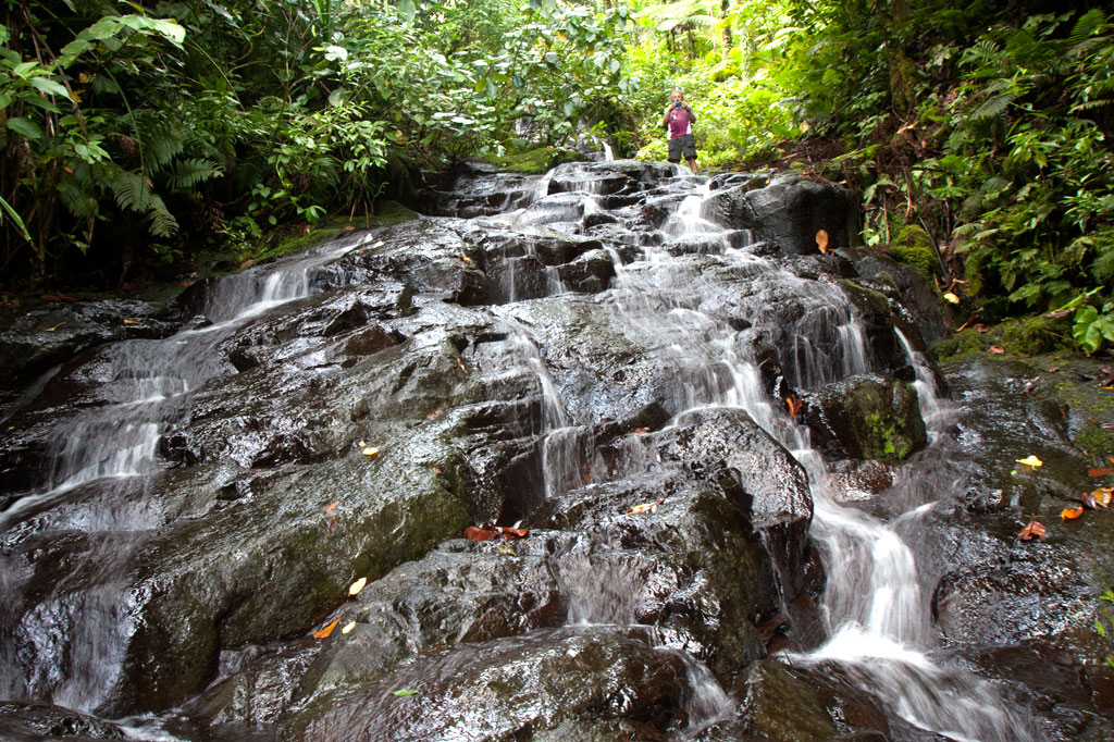
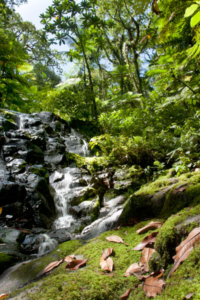
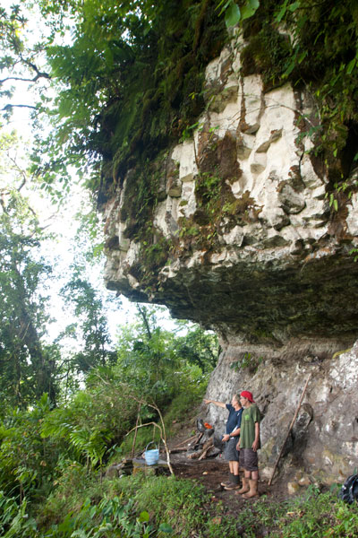
Nan Kiepw
Nan Kiepw, which means “in the lilies,” is a hillside overshadowed by Dolmweir peak. A Pohnpeian myth tells of a Yapese magician, named Sou Iap, who voyaged to Pohnpei and was responsible for the creation of Sokehs Rock). One of Sou Iap‘s companions, Souliken And, noticed a girl collecting clams on a reef north of Sokehs Island, and thinking her very attractive, chased her deep into Nett, carrying an ihd leaf with him. On the hillside below Dolmweir peak, Souliken And lost his leaf and named the place after a species of white lily he saw there.
During the Sokehs Rebellion in 1910, Pohnpeian rebels fleeing from German and Melanesian troops briefly took refuge at Nan Kiepw, rebuilding some earthen fortifications from the Spanish Period and repelling a small attack.
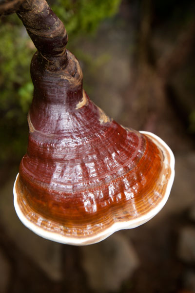
Today, Nan Kiepw maintains a pristine beauty that betrays no sign of past violence. A tributary of the Nanipil River (Pillapen Nanipil) runs through the area, forming a wide gentle cascade, some small pools (though none big enough for swimming), and a “horsetail” waterfall before winding into the valley. Upstream is a basalt outcropping — really a great boulder — that forms an overhang where a few people can comfortably camp out of wind and rain. Huge ivory nut trees, red sandlewood, and a variety of hardwoods dominate the lush native forest, and there are many unusual varieties of fungi to be seen.
The Origin of the Ivory Nut Palm
On the fourth voyage to Pohnpei after its founding, a man came named Mederiap, bringing with him the ivory nut palm and propagating it on the island. Prior to this time people had mostly lived in caves, because they had nothing to use for roofing material, but ever afterward, the fronds of the ivory nut palm were woven together to produce roof thatch for houses.
The moderately challenging trail begins behind a house near the Nett hydroelectic building at the end of the Nanipil River Road (the same trailhead for Nahnalaud). Hikers cross the Nanipil River directly and walk along a well-maintained footpath for 0.99 km / 0.61 mi (5% slope avg) before coming to the first major branch. The left (east) branch leads on toward Nahnalaud, while the right (west) branch heads to Nan Kiepw. From this point it’s 1.4 km / 0.87 mi (14% slope avg) to the last residence along the trail at 265 meters of elevation, and then another 1.8 km (1.12 mi) to the waterfall. This last segment has two little ascents with slope averages of about 20% and 26% and a more moderate bit in between (11% slope avg). Sakau (kava) plantations are found on both sides of the trail much of the way. Hikers should take care to avoid damaging these valuable plants.
[info], Pohnpei, Federated States of Micronesia (FSM)")
Crab’s Eye Vs. Red Sandlewood: What to Know and Why it Matters
Two species of trees found both in inhabited areas and in the upland forests of Pohnpei produce small brilliant red seeds about the size of popcorn kernels. These can be seen scattered across the forest floor and often on the trail leading to Nan Kiepw. Red seeds with a single black dot on them belong to Abrus precatorius (Crab’s Eye Seed or John Crow Bead), while solid red seeds come from Adenanthera pavonina (Red sandlewood). The first type of seed (with the black dot) contains a compound, called abrin, that is 75 times more toxic than ricin and can be fatal if ingested; the fatal dose is about 0.1 mg for an adult of roughly 68 kg (150 lbs). Symptoms of poisoning include nausea, vomiting, convulsions, liver failure, and death after several days. The second type of seed (all red) is harmless when cooked and is sometimes eaten as a snack by Pohnpeian children. Strangely, the same Pohnpeian name — kaikes — is used to identify the two species of trees. Both Abrus precatorius and Adenanthera pavonina originate on the Indian subcontinent. Seeds are sometimes used to make necklaces and other jewelry.[/info]
Na Malek
Na Malek (“his chickens”) is a rock overhang and cave — located in the part of upland Nett once known as Nansokele — said in myth to have been the home of the demon Taimuan. The site, which has excellent views of the valley, Dolen Eirike, and Dol Rakied, is reached via a steep loop of path (0.61 km / 0.38 mi with a 42% slope average) that branches off from the Nan Kiepw trail. The overhang is large enough to provide a protected camping spot, and the elevated cave is bone-dry, flat-floored, and suitable for sleeping. Water running off the rock can be filtered for drinking. This is a relaxing and beautiful place to watch birds, including the Grey White-eye and rare Long-billed White-eye.
- Plan for 8 hours for both Nan Kiepw and Na Malek.
- Please visit the Local Guides & Tour Operators page for a list of experienced guides available for hikes to Nan Kiepw. Offer $50.00 for a group of five or less.
The Tale of Taimuan
A well-known Pohnpeian myth states that Na Malek was the the home of a hideous old demon, named Taimuan, and his sister, Litapinmalekelek. Taimuan had a hankering for human flesh and was, in particular, interested in the beautiful daughter of the Saudeleur — the supreme ruler that reigned from Nan Madol. Deciding that he wished to devour the girl, Taimuan set out for Nan Madol, transforming himself into a handsome young man along the way and leaving his old parts at different points in the mangroves — his white hair, swollen legs, swollen testicles, sagging eyelids, etc. When Taimuan arrived at Nan Madol and presented himself to the Saudeleur, both the girl — who was called Kisin Ntamwahu (“a little bit of good blood”) — and her father were impressed with the young suitor. Kisin Ntamwahu fell for Taimuan and begged her father to let them marry. Soon the two were married and given a home on Pahn Kadira.
After residing at Pahn Kadira for a while, however, Taimuan obtained permission from the Saudeleur to take Kisin Ntamwahu back to Na Malek. On the way, he picked up all his old parts from the mangroves and was restored to his prior appearance. Kisin Ntamwahu realized she had been tricked, but Taimuan carried her away against her will and confined the girl inside the cave at Na Malek. Then he climbed to the top of the mountains to invite all the other demons in the area to join him in feasting on the girl. While he was away, his sister, Litapinmalekelek, discovered Kisin Ntamwahu and felt sorry for her. She began to dig the girl out of her prison and encouraged Kisin Ntamwahu to turn herself into an ant, in order to escape, and flee into the forest. She warned the girl not to pass any plants without greeting them politely. As Kisin Ntamwahu ran, she greeted all the plants, big and small. All except one. Feeling a sudden need to urinate, she relieved herself in the forest and didn’t realize she’d done so on a plant called kampanial.
When Taimuan found that Kisin Ntamwahu was gone, he confronted Litapinmalekelek, but she claimed to know nothing. In a rage, Taimuan showered his sister with obscenities (specifically, he shouted, “Your vagina! My penis!” — a highly offensive reference to an act of incest) and then took off into the forest to catch Kisin Ntamwahu. He questioned each plant he passed, but none would tell him anything until he came upon the kampanial, which told Taimuan which way Kisin Ntamwahu had gone. Shortly thereafter, Taimuan met two worms on the path. He asked them where the girl had gone and they promised they would tell him if he pulled down his eyelids. He did so, and the worms threw dirt in his eyes. When Taimuan tried to wash his eyes out in a nearby streamlet, the worms muddied the water upstream, causing him to go blind and eventually die.
- Please visit the Local Guides & Tour Operators page for a list of experienced guides available for hikes to Nan Kiepw.