
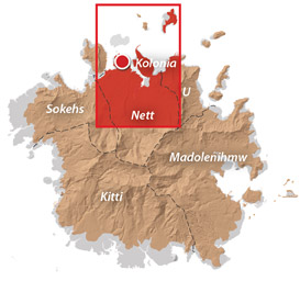
Nett & Western U GPS Data
Downloadable GPS Data Files
The following files contain all the packaged GPS data for each of the featured locations in Greater Nett & Western U.
Three file types are provided. KMZ and KML files are compatible with Google Earth. KML is compatible with Google Maps. GPX files can be imported into ArcGIS (a professional mapping application) and some hand-held GPS devices.
[info]NOTE: All files are free to the public and can be used for any purpose without permission.[/info]
Marine Parks in Awak Pah (2015)
Dolen Eirike (2015)
Dolen Nahnsapwe (2015)
Lou Rahn Cave & Waterfall (2015)
Nan Kiepw & Na Malek Cave (2015)
Nan Koropwung Cliff, Waterfall & Caverns (2015)
Dolen Nett / Pohnlehr (2015)
Nanipil Vicinity (2015)
These files include Liduduhniap, Sengnaip, Likei, Pahn Pwet, and Nan Kiepw waterfalls, the Nanipil Bird Walk, the Swimming Pond, and another popular swimming hole in the area.
Coordinates
The following coordinates correspond with sites featured on the Greater Nett & Western u Eco-Adventure Map Guide. It is our dream to eventually create a Pohnpei GPS app that could be uploaded to smartphones and other devices, but for now, these points of interest can be entered manually in a hand-held GPS device as needed.
[info]NOTE: All GPS devices have a margin of error. That margin increases with interference — when there is a thick canopy of trees, during bad weather, or when mountains obstruct the satellite link. The geosynchronous satellites employed when navigating on Pohnpei are located low on the southwestern horizon, such that maintaining a strong connection while hiking on the northeast side of a given mountain range can be difficult. Coordinates on the northeastern slopes of mountains are less accurate than in other locations.[/info]
Awak Marine Parks
| Awak Pah MP Entrance | —- | 6.965910° 158.250758° |
| Pein Ahi Entrance | —- | 6.966711° 158.251138° |
| Paieke Entrance | —- | 6.969853° 158.256294° |
| Awak Pah MP Dock | —- | 6.966470° 158.248785° |
| Pein Ahi Fish Pond | —- | 6.967572° 158.249929° |
Dolen Eirike
| Relio Lengsi’s Residence | —- | 6.926688° 158.227910° |
| Dolen Eirike Trailhead | —- | 6.919570° 158.227397° |
| Sakau Plantation | —- | 6.917106° 158.227410° |
| Japanese Trench Network | —- | 6.915589° 158.230300° |
| Dolen Eirike Summit | —- | 6.915140° 158.231599° |
| Dol Rakied Summit | —- | 6.906234° 158.237645° |
Dolen Nahnsapwe
| Dolen Nahnsapwe Trailhead – Nett Approach | —- | 6.927169° 158.246675° |
| Dolen Nahnsapwe Trailhead – U Approach | —- | 6.918897° 158.270844° |
| Dolen Nahnsapwe Summit | —- | 6.909546° 158.260936° |
| Dolen Nahnsapwe Turn-Off from Lou Rahn Trail | —- | 6.923336° 158.249283° |
Lou Rahn
| Lou Rahn Trailhead | —- | 6.927169° 158.246675° |
| Lou Rahn Cave & Waterfall | —- | 6.918551° 158.253955° |
Nan Kiepw & Na Malek
| Nan Kiepw / Na Malek / Nahnalaud Nett Trailhead | —- | 6.918179° 158.214601° |
| Stream Crossing | —- | 6.917458° 158.215238° |
| Nahnalaud Turn-Off from Nan Kiepw Trail | —- | 6.910792° 158.217769° |
| Last House along trail | —- | 6.900363° 158.214973° |
| Na Malek Loop Turn-Off from Nan Kiepw Trail | —- | 6.897523° 158.213266° |
| Na Malek Loop Turn-Off from Nan Kiepw Trail | —- | 6.895756° 158.213144° |
| Na Malek Cave | —- | 6.895878° 158.211765° |
| Kiepw Waterfall | —- | 6.889668° 158.211740° |
| Nan Kiepw Overhang & Campsite | —- | 6.889639° 158.211035° |
Nan Koropwung
| Nan Koropwung Trailhead | —- | 6.925729° 158.254909° |
| Cliff & Waterfall | —- | 6.927155° 158.259679° |
| Cave 1 | —- | 6.927513° 158.259859° |
| Cave 2 | —- | 6.927877° 158.259142° |
| Cave 3 | —- | 6.927884° 158.259038° |
Dolen Nett / Pohnlehr
| Dolen Nett Trailhead 1 | —- | 6.968282° 158.230457° |
| Dolen Nett Trailhead 2 | —- | 6.965640° 158.234757° |
| Dolen Nett Trailhead 3 | —- | 6.959650° 158.225124° |
| Dolen Nett Trailhead 4 | —- | 6.969614° 158.228438° |
| Japanese Tunnel Entrance | —- | 6.965840° 158.228329° |
| Yam Plantation | —- | 6.965248° 158.228609° |
| Japanese Defensive Position | —- | 6.964007° 158.229053° |
| Japanese Trench Network | —- | 6.963868° 158.229051° |
| Japanese Trench Network | —- | 6.963073° 158.229706° |
| Japanese Trench Network | —- | 6.963105° 158.229949° |
| Japanese Trench Network | —- | 6.963125° 158.230125° |
| Japanese Trench Network | —- | 6.963025° 158.230332° |
| Pandanus Grove | —- | 6.961883° 158.230662° |
| Coconut Palm Grove | —- | 6.961188° 158.231013° |
| 80 mm Field Gun | —- | 6.958862° 158.233030° |
| Rusted Barrels | —- | 6.958814° 158.233064° |
| 80 mm Gun in Bunker | —- | 6.958838° 158.233535° |
| Machinegun Bunker | —- | 6.958741° 158.233545° |
| Bunker | —- | 6.958765° 158.233415° |
| Pohnlehr Summit | —- | 6.958226° 158.233346° |
| Japanese Mobile Radar Array | —- | 6.958767° 158.232402° |
Sengnaip Waterfalls
| Trailhead | —- | 6.920677° 158.204421° |
| Route Intersection | —- | 6.920647° 158.201060° |
| Sengnaip Cave | —- | 6.917556° 158.200460° |
| Sengnaip Waterfalls | —- | 6.917522° 158.200383° |
Likei & Pahn Pwet Waterfalls
| Trailhead | —- | 6.920677° 158.204421° |
| Route Intersection | —- | 6.920647° 158.201060° |
| Stream Crossing | —- | 6.919559° 158.198878° |
| Log Crossing | —- | 6.916577° 158.198932° |
| Route Intersection | —- | 6.916577° 158.198932° |
| Route Intersection | —- | 6.914373° 158.199648° |
| Route Intersection | —- | 6.904178° 158.192649° |
| Route Intersection | —- | 6.904178° 158.192649° |
| Likei Waterfall | —- | 6.903375° 158.189810° |
| Pahn Pwet Waterfall | —- | 6.902343° 158.192313° |
Nan Kiepw Waterfall
| Trailhead | —- | 6.919873° 158.206230° |
| Route Intersection | —- | 6.914373° 158.199648° |
| Nan Kiepw Waterfall | —- | 6.897512° 158.206958° |
Liduduhniap Waterfalls
| Trailhead | —- | 6.919915° 158.206706° |
| Upper Pool | —- | 6.918893° 158.206592° |
| Upper Falls | —- | 6.918891° 158.206557° |
| Lower Pool | —- | 6.918564° 158.206676° |
| Lower Falls | —- | 6.918695° 158.206572° |
Nanipil Vicinity
| Nanipil Bird Walk Trailhead | —- | 6.920677° 158.204421° |
| Nanipil Bird Walk Trail End | —- | 6.919559° 158.198878° |
| Hydroelectric Building | —- | 6.918222° 158.214670° |
| Japanese Pump Station | —- | 6.918404° 158.214481° |
| Swimming Pond Trailhead | —- | 6.922461° 158.215089° |
| Swimming Pond | —- | 6.922642° 158.215955° |
| Cable Bridge Swimming Hole | —- | 6.932656° 158.216346° |
Dolen Nahnsapwe
![]()
![]()
![]()
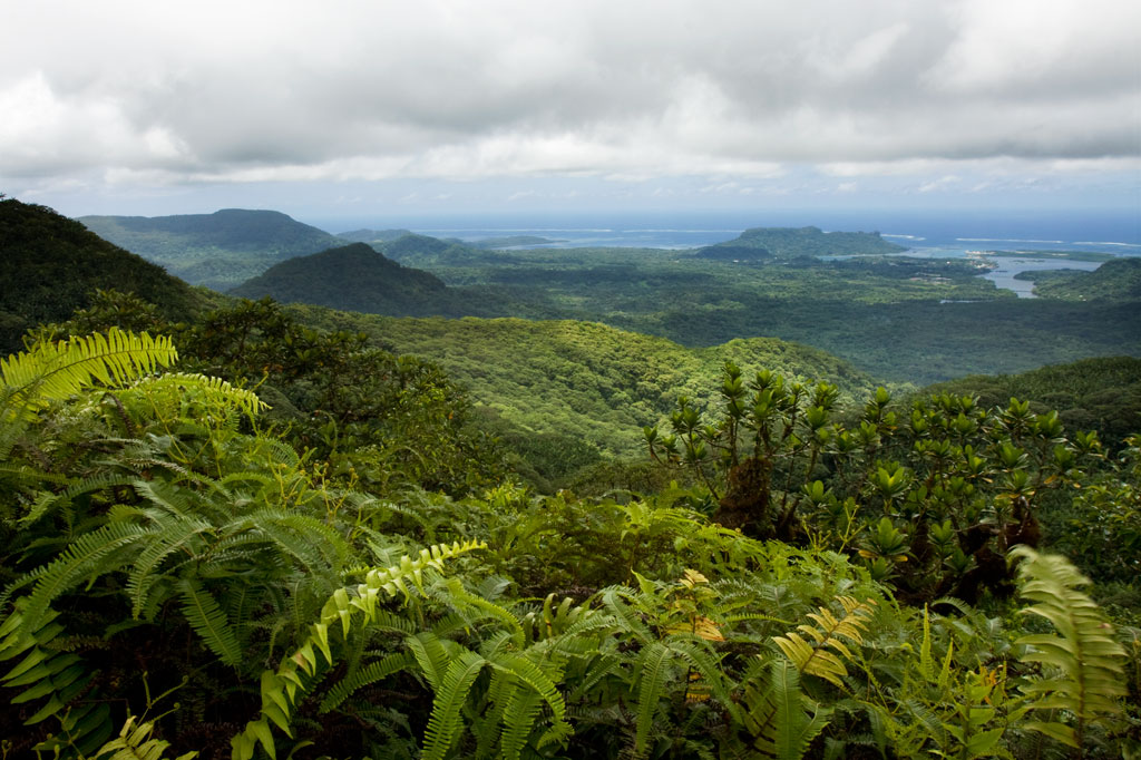
Dolen Nahnsapwe, “hill of thunder,” is a small peak near the Nett–U border. As the crow flies, it’s about 1.3 km (0.8 mi) southwest of the Kupwuriso summit. Though rarely visited and not the highest point in the area, Dolen Nahnsapwe is intriguing because it’s associated with stories about the traditional thunder god, Nahnsapwe, and is said to be the place where thunder storms originate. It’s also the source of the Pwong-Kapwungapwung watercourse, a stream that forms a waterfall below the Lou Rahn ridge in Nett. It’s a challenging climb that follows a trail only part of the way, but the pay-offs come in the form of soaring vistas and gorgeous upland forests. You can approach the peak from either Nett or U or do a full traverse (6.75 km / 4.2 mi) from one side to the other.
Nett Approach
The Nett approach to Dolen Nahnsapwe feels wilder and is steeper and more strenuous. It begins on the side of an unpaved road in Paremkep. The first 0.6 km (0.37 mi) follows the same track that goes to Lou Rahn waterfall and cave with a gentle slope average of about 12%. After that, it branches off and climbs more steeply along the Lou Rahn ridgeline for 2.65 km (1.65 mi) with a slope average ranging between 20% and 25%. This brings hikers to the foot of the peak — a swampy area dominated by thickets of kotop (Clinostigma ponapensis) palms.
U Approach
The way up from U begins behind a cluster of houses at the end of the last road before the Madolenihmw border. On this side, things are much more developed and the trail is clear and well-maintained nearly to the top of the pass north of the peak. One conservation worker told us that sakau farmers from U frequently use this route to access illegal plots in the watershed on the Nett side. The 3.2 km (2 mi) trail meanders through inhabited areas and past a number of a small huts and residences (23% slope avg).
The last bit up to the tiny summit (593 m) is an over-grown, steep (46% slope avg), grubby, and sometimes unnerving scramble from the northwest side. The summit is tiny, and the ground up there has a springy, unstable feel as if you’re actually standing on layers upon layers of ferns and moss rather than solid ground — which may be the case. The effort and unease, however, are rewarded with a truly marvelous 300-degree view. Sokehs Mountain (276 m), Kolonia Town, the open summit of Kupwuriso (630 m), and Dolen Saldenre (629 m) are all visible — weather permitting.
You can do this climb as a day-hike, but a better option is to camp somewhere along the upper Pwong Stream (Pilen Pwong). Remember to pack out everything you packed in. A responsible camp site is one that is invisible once its occupants depart.
- Plan for 8 hours for this hike.
- Please visit the Local Guides & Tour Operators page for a list of experienced guides available for hikes to Dolen Nahnsapwe. Offer $50.00 for a group of five or less.