
An Introduction to Pohnpei
Pohnpei, the Ultimate Adventurer’s Paradise
 Imagine an island that still retains its wildness — a place of rugged, breathtaking beauty, vibrant traditional culture, unpaved remoteness, and mystery. Imagine a landscape so green that it threatens to burn a hole in your retina. Picture being the only snorkeler on a pristine reef, surfing one of the world’s most celebrated waves, diving in a place most divers have never dreamed of, climbing misting mountain peaks, exploring a prehistoric megalithic city, or trekking through lush rainforests. This, in a nutshell, is Pohnpei.
But, Where the Heck is It?
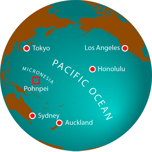
The short answer? 4,828 kilometers (3,000 miles) southwest of Hawaii and 3,700 kilometers (2,300 miles) northeast of Australia. Pohnpei is the largest and highest island in the Federated States of Micronesia (FSM), a far-flung oceanic nation with some 600 islands spread across a vast section of the western Pacific between Hawaii and the U.S. Territory of Guam. The FSM is one of the most culturally diverse areas in the Pacific with more than twenty distinct groups and as many unique languages. The country is divided into four states (from east to west) — Kosrae, Pohnpei, Chuuk, and Yap. The capital of the FSM is located at Palikir on the west side of Pohnpei Island. In addition to the main island, Pohnpei State also includes four inhabited Micronesian atolls, two distant Polynesian outliers, two uninhabited atolls, and a submerged atoll.
They Don’t Call It the Garden Isle for Nothing
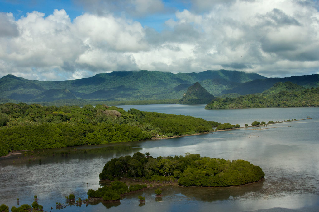
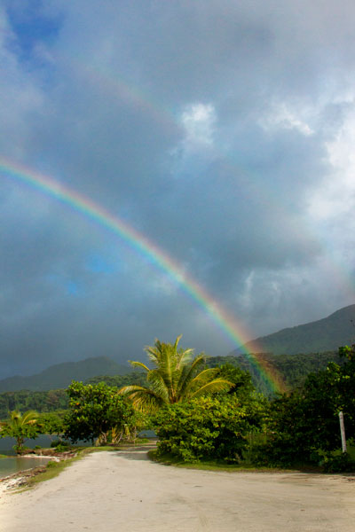
Roughly 22.5 kilometers (14 miles) in diameter, Pohnpei Island is the peak of a 5 million-year-old extinct shield volcano that has subsided over its lifetime. Some say it bears a resemblance to Bora Bora minus the unchecked development. Others liken it to something out of a Robert Louis Stevenson novel. Both would be correct. The place is rugged and brilliant green with a dense rainforested interior and mountains as high as 780 meters (2,600 feet). With 825 centimeters (325 inches) of rain a year in the interior, Pohnpei ranks as the seventh rainiest location on Earth. All that water adds up to more than 40 watercourses, scores of scenic waterfalls, and some of the largest areas of intact upland rainforest in the Pacific.

A Marine Wonderland
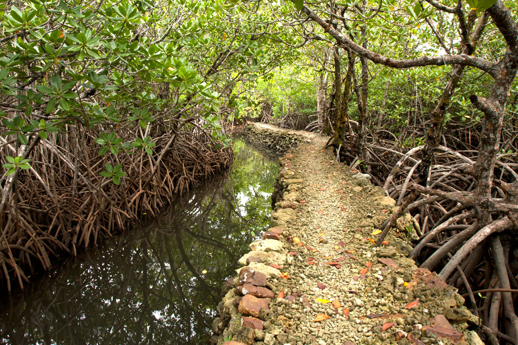
Pohnpei’s coasts are entirely encircled by shadowy mangrove forests that are more than 3 kilometers (2 miles) wide in places and provide a maze of narrow, tunnel-like channels for kayaking, canoeing, or stand-up paddleboarding (SUP) enthusiasts. This environment is a serene domain of birds and other creatures. A half to one and a half kilometers further out, a barrier reef curves around 70% of the island, forming a large, placid lagoon with passages going out into the open ocean — prime spots for surfing, snorkeling, and SCUBA diving. Small volcanic islands are scattered about within the lagoon and coralline islands with sandy beaches perch along the reef itself, calling to campers and beach-bums.
In short, there’s a little bit here for everyone . . .
Madolenihmw Bay Area
![]()
![]()
![]()
![]()
![]()
![]()
![]()
![]()
![]()
![]()
![]()
![]()
![]()
![]()
![]()
Dauen Sapwalap / Senipehn Mangrove Reserve
- Visit the Paddling Around Madolenihmw page for a detailed description of this location and the adventures to be had in the area.
- Entering the mangrove reserve requires a permit. Visit our MPA page for details.
Kamau Pwoungapwoung
Though we didn’t map the hike to this destination as part of the eco-adventure map series (for lack of time), it would, never the less, be an exciting adventure to consider. Kamau Pwoungapwoung refers to a freshwater pool and waterfall at the headwaters of the Dipwilap Stream (Pilen Dipwilap), one of the tributaries of the Senipehn River (Pillapen Senipehn). The place is significant as the location where the last battle between the Saudeleur‘s warriors and Isokelekel’s men was fought. Upon being defeated by Isokelekel, the Saudeleur transformed himself into a small blue fish, that inhabits the pool to this day, and leaped into the waterfall. The hike would be a long one from the area around Pahn Sile. The closest access point would probably be from the direction of Nihpit fern meadow (reached from eastern Kitti).
- The absolute best choice for a guide is Relio Lengsi. Give him a call at +691.924.2580 and discuss the best route options and access points for this location. Offer $50.00 for a full-day hike.
Nanpahlap Peak
The 137 m (449 ft) hill to the east of Takaiuh looks as if its top has been lopped off — which fits in with the story about its creation (see Takaiuh below). Though steep in places and somewhat overgrown, the ascent isn’t too strenuous. At the summit are the tumbled ruins of a prehistoric stone structure and a breath-taking view. The whole area around the southern foot of the hill is criss-crossed with Japanese trenches and dotted with tunnels, including at least one very long one leading into the hill. The grid of paddies and irrigation canals where the Japanese successfully cultivated rice (despite Pohnpei’s challenging climate conditions) are found on both sides of the unpaved access road, though you can get closest to the bulk of these fields from another road to the west.
Everything is private land, but no official access fees are charged.
- To hire a guide, ask at the houses in the area or contact Hanke Albert at +691.320.4047. Offer $25.00 for Nanpahlap or a half-day of exploration in the area.
Nanwap Marine Protected Area (MPA)
Nanwap Marine Protected Area is a 3.05 km2 (305 hectare) section of the barrier reef and adjacent lagoon areas on the north side of Kepidauen Deleur (passage). The sanctuary was founded by community members from Metipw and Lukop and their respective chiefs and gained legal status in 2010. It became the first of Pohnpei’s MPAs to have its own formal community-created management plan with the support of the Pohnpei MPA Executive Management Network and the state offices of the Department of Land and Natural Resources, Division of Fish and Wildlife, Office of Fisheries and Aquaculture, and Environmental Protection Agency. Nanwap is a “no-take zone,” which means no fishing or gathering of any kind is allowed within the boundaries. It is regarded as the “most biologically diverse and best preserved spawning and aggregation site” for many of Pohnpei’s core reef fish species. Snorkelers should seek out the protected blue holes on the west side of the reef, while SCUBA divers will want to do a drift dive on the southern wall of the reef during an in-coming tide.
- Entering the MPA requires a permit. Visit our MPA page for details.
Pahn Dieinuh
- Visit the Paddling Around Madolenihmw page for a detailed description of this location.
Peiai
Peiai is a small populated place near the turn-off for Pahn Sile waterfall. During the battle between the warriors of Isokelekel and the army of the last Saudeleur, Peiai was the place where the tide of battle turned dramatically (hence, the name references a situation where the runner-up in a race pulls ahead of the leader — loosely translated “the battle is reversed”). Isokelekel’s men were being beaten down by the forces of Nan Madol when one of the conqueror’s greatest fighting men pinned his own foot to the ground with his spear, refusing to retreat and declaring that he would kill any man who tried to run away from the fight. Isokelekel’s men rallied behind this show of bravery and pushed back the Saudeleur‘s warriors, chasing them up the Senipehn River and eventually to Kamau Pwoungapwoung, a waterfall at the headwaters of the Dipwilap Stream, where the Saudeleur was finally defeated.
Sapwalap
Sapwalap (“large land”) is an expansive region of mostly flat ground that makes up a sizable chunk of central Madolenihmw. The Japanese recognized Sapwalap‘s potential as a site of large-scale agriculture. During the thirty years leading up to World War II, sugarcane was cultivated and processed at a facility near Kitamw (the tower is still partly visible in the jungle off the road) and rice was grown in a patchwork of paddies fed by irrigation canals. Strangely, no one is growing rice these days, but the paddies are still there opposite the gleaming LDS Church. Other fields are found as far east as Lukop.

Tahio
Tahio, on the south side of Nanpahlap, is another place where the Japanese were active. The access road was built by them and the coastal area is full of trenches, rifle pits, dugouts, and tunnels. Everything is overgrown, but anyone who pokes around will be rewarded with interesting finds. Bring a local resident along.
Takaiuh Peak
You can’t visit Madolenihmw without being arrested by the sight of Takaiuh, a 160 m (525 ft) peak shaped like a traffic cone that stands on the north side of the bay and seems to guard the entrance to the Sapwalap estuary. The mythical origin-story of the hill — which bears a striking resemblance to the Biblical tale of the tower of Babel — involves Mwohnmur and Sarapwau, two wily brothers who enter into many Pohnpeian legends (they also created the Sahwar Valley and the rock of Pohnpaip).
How Takaiuh Came to Be
Long ago, two boys named Mwohnmur and Sarapwau were born in Salapwuk (Kitti) to a woman named Lienlama. The boys were always involved in clever schemes and mischief and traveled far and wide doing great works. Once, the brothers took a piece of stone, and using it like a canoe, paddled to Pohndolen Imwinsapw near what is now Tahio in Madolenihmw. There, Mwohnmur and Sarapwau amused themselves by piling up rocks until they had formed a large hill. A local demi-god named Lapongo saw what they were doing and wasn’t pleased, so he threw a stone at their hill and destroyed it. He then challenged the brothers to a competition to see who could build a mountain the fastest. The three set to work, but it soon became apparent that the boys were winning. Their mountain was so tall it had reached the sky. Being a poor loser, Lapongo became enraged. He picked up a stone and threw it at the new mountain, which broke into six pieces. The base of the mountain that remained standing was named Takaiuh (“standing stone”).
This was not the end of the conflicts between the brothers and Lapongo, however. Lapongo mocked and ridiculed the boys whenever he could, and they did not like it. Now, the brothers liked to play at a place called Pahnlikes, below the spot where they had settled on Likes peak west of modern-day Sapwalap. There was a steep slope there that they would slide down for fun, sitting upon the leaf sheaths of the kotop palm (Clinostigma ponapensis). The boys knew that Lapongo had been watching them and was aware of their play place, so they decided to trick him. Lapongo was invited to slide down the slope with the boys, but they chose a spot where the slope ended at the waterside (possibly the southern tributary of Pilen Kitamw). All three began sliding down the hill. When Mwohnmur and Sarapwau reached the bottom, they leaped off their sheaths and dived to safety, but Lapongo went straight and fell into the water. He sank down into the depths, and the brothers threw rocks on top of him to keep him from resurfacing.
Takaiuh is actually an island separated from the coast by a strip of mangrove forest. It was once inhabited, but is no longer. Though the hill is climbable, the ascent is extremely dangerous, characterized by very steep slopes and cliffs prone to rockslides with little or nothing solid to hold on to. For this reason we strongly advise visitors to enjoy Takaiuh from below rather than trying for the summit. Hikers who insist on seeking the summit, do so at their own risk. Distant views of the peak are found along the Circle Island Road, but the best close-up view from land is from the old Japanese road in Kepine. According to residents living in the area, the Japanese abandoned an attempt to build a trail all the way to the top of the hill. Some of the low wall can still be seen on the lower slope.
Marine Parks
Nihco Marine Park
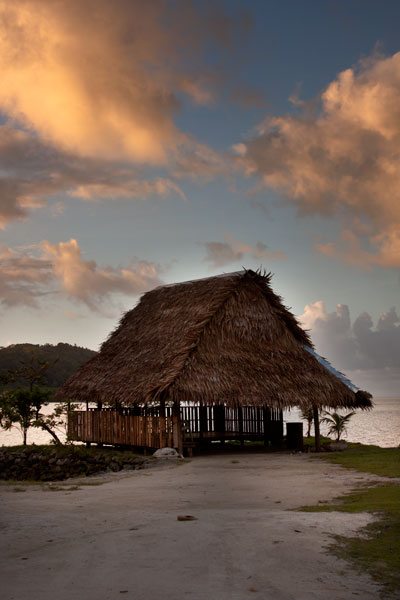
Nihco Marine Park, on the southwest coast of scenic Sokehs Bay is an appealing place for people of all ages to swim, barbecue, and soak up the sun. The park is comprised of a narrow, man-made semi-circle of sand with a placid lagoon in the middle where turtles and reef fish are kept. There’s a white-sand beach on the outer edge and simple thatched huts for either day or overnight visits. Small kayaks can be rented for a few dollars. The place can be packed on weekends and holidays.
- To make reservations for day visits, call +691.320.2135 / 4659.
Awak Pah Marine Park
Awak Pah Marine Park is the most well-known of the parks in the area and has a nice big sign right out on the main road. From the parking area near the owner’s house, a 0.2 km (0.12 mi) coral and concrete walkway leads to the water through a dense section of mangrove forests. At the end, there’s a tiny picnic area by the water, a large nahs, and a few other huts that can be rented at an extra cost. The water is shallow and a bit silty on the south side and deep on the west and northwest side where a huge pair of PVC rings have been anchored (a good place to swim). The rock wall by the water is a fun place to jump from, but it can be difficult to climb back out. Snorkeling can be pretty good to the west along the reef wall with lots of small fish and some interesting coral growth. Unfortunately, local visitors have been careless with their garbage and the beautiful reef scenery is frequently ruined by the presence of discarded aluminum soda cans or flashlight batteries — a sad trend on Pohnpei. Water clarity varies from crystal clear to murky depending on the tides; it’s best to visit on an in-coming tide. You can visit Awak Marine Park without making arrangements beforehand.
Paieke Marine Park

This pleasant, breezy swim-picnic-camp park is located on a network of dredged coral causeways that extend out into the lagoon at the point where the road begins to turn east toward the Awak valley. A number of thatched residential huts varying in size and a nahs (meeting hut) or two are positioned around the water’s edge for guests at an extra cost. The swimming is good all along the west side, though the shallows tend to be silty rather than sandy. Snorkelers should follow the edge of the reef further out into the lagoon for best results. The kids will love tinkering around in the shallows under the shady trees. Paieke operates on a reservation-only basis.
- To make reservations for visits call +691.925.0382.
Pein Ahi Marine Park
This charming, but little-known, park (pictured at top) is found just after Awak Marine Park, but as it lacks a sign, most people drive right by without realizing it’s there. From the road, a beautiful 0.16 km (0.1 mi) stone and coral walkway winds through the picturesque mangrove forests and ends at a grassy picnic area with a nahs and a large fish pond. The family keeps some very curious pufferfish and a few other reef fish in the pond, mostly for the amusement of visiting local children. The swimming all around the outside of the pond walls is excellent with consistently good water clarity. There’s a relatively shallow area on the south side that works well for kids or beginning swimmers and deeper water on the west and north. They also have a pair of large bamboo-pontoon rafts that are fun to cruise around the mangrove fringe on. Except on big holidays, you can usually visit without making any prior arrangements.