
Takaieu & Dehpehk Islands
Takaieu and Dehpehk are two large volcanic islands connected by a bridge and linked to the coast of U by a causeway. Most of the local residents live around the eastern and northern coasts of Takaieu and the western coast of Dehpehk and commute to and from Pohnpei by boat. The islands are fun to explore if you want to get a glimpse of old-style Pohnpeian life sans roads and electricity. A seaward turn just before the Madolenihmw border brings one to the unpaved causeway. A well-maintained footpath runs east around Takaieu, crosses the Dehpehk-Takaieu Bridge, continues on the west coast of Dehpehk, and then wraps around the eastern coast, where it connects with another trail going over the interior hill. The marine areas along the eastern coast belong to the Dehpehk Marine Protected Area (MPA). No permission is needed to visit either island, but do be respectful and stay on the main paths around the inhabited areas.
")
Takaieu Island
Takaieu figures into a well-known local myth about two magical brothers. The island is said to have been created when these brothers dragged a large rock all the way from Yap — hence the name, which means “one rock.” The causeway road ends not far along the south coast and is replaced by a tidy rock footpath (vehicles can be parked on the side of the road near the trailhead). From there, the path bends around the mangrove-fringed eastern coastline, passing neatly maintained farmsteads here and there. Mwelling marks the spot of one of the megalithic structures built by Olsihpa and Olsohpa before they founded Nan Madol. The site is impressive, but is easier to reach by boat than from land. About halfway across the north side of the island, the path turns and connects with Dehpehk via a small concrete footbridge.
The Origin of Takaieu Island
There was once a woman in Salapwuk named Lienlama who had two sons named Mwohnmur and Sarapwau. The boys were quite mischievous and had many adventures that figure into Pohnpeian myth. In one story, the brothers went to the islands of Yap and used a magic spell to make a stone fly from that place to Pohnpei. They flew the stone to Wenik (modern-day U) and set it down in the lagoon, naming it Takaieu (“one stone”). They had brought some southern yams with them and they cooked these up, but threw the parts that were underdone into the forests of Alohkapw and Edienleng. And so they southern yam was first propagated in those places.
Dehpehk Island
Dehpehk is long and skinny with a low ridge running along its length. Like Takaieu, it forms its own sub-division, or kousapw, The trail on the west coast is narrow, but heavily used as there are many residences on this side. Once you’ve reached the northern extreme of Dehpehk, however, there’s little reason to go further as the trail gets steadily harder to follow where many of the houses have been abandoned. If you do want to continue, you’ll end up at a homestead with a large piggery. Here the path turns west and climbs over the central hill, reconnecting with the western coastal trail. There’s a nice elevated view from a point just below Dolen Dehpehk (100 m).
- Plan for 7-8 hours for this hike.
- To obtain a guide who can show you around both islands contact Pohnpei Surf Club as one of their boat drivers / dive masters is from the area and can provide assistance with exploring the islands.
U & Northern Madolenihmw GPS
Downloadable GPS Data Files
The following files contain all the packaged GPS data for each of the featured locations in U & Northern Madolenihmw.
Three file types are provided. KMZ and KML files are compatible with Google Earth. KML is compatible with Google Maps. GPX files can be imported into ArcGIS (a professional mapping application) and some hand-held GPS devices.
[info]NOTE: All files are free to the public and can be used for any purpose without permission.[/info]
Dolen Nahnsapwe Hike (2015)
Kupwuriso Mountain & Japanese Gun Battery Hike (2015)
Marine Parks in Awak Pah (2015)
Pahntakai Caves & Waterfall Hike (2015)
Timwen Men, Dolakapw & Pohn Tehnmei Hikes (2015)
Coordinates
The following coordinates correspond with sites featured on the Greater Nett & Western u Eco-Adventure Map Guide. It is our dream to eventually create a Pohnpei GPS app that could be uploaded to smartphones and other devices, but for now, these points of interest can be entered manually in a hand-held GPS device as needed.
[info]NOTE: All GPS devices have a margin of error. That margin increases with interference — when there is a thick canopy of trees, during bad weather, or when mountains obstruct the satellite link. The geosynchronous satellites employed when navigating on Pohnpei are located low on the southwestern horizon, such that maintaining a strong connection while hiking on the northeast side of a given mountain range can be difficult. Coordinates on the northeastern slopes of mountains are less accurate than in other locations.[/info]
Awak Marine Parks
| Awak Pah MP Entrance | —- | 6.965910° 158.250758° |
| Pein Ahi Entrance | —- | 6.966711° 158.251138° |
| Paieke Entrance | —- | 6.969853° 158.256294° |
| Awak Pah MP Dock | —- | 6.966470° 158.248785° |
| Pein Ahi Fish Pond | —- | 6.967572° 158.249929° |
Dolen Nahnsapwe
| Dolen Nahnsapwe Trailhead – Nett Approach | —- | 6.927169° 158.246675° |
| Dolen Nahnsapwe Trailhead – U Approach | —- | 6.918897° 158.270844° |
| Dolen Nahnsapwe Summit | —- | 6.909546° 158.260936° |
| Dolen Nahnsapwe Turn-Off from Lou Rahn Trail | —- | 6.923336° 158.249283° |
Paddling in Nett, U & Northern Madolenihmw
Dausokele Estuary
As paddling goes in the Nett region, Dausokele estuary (“channel of the dwarves”) is the crown jewel, a long, gorgeous inlet that lies between Kolonia and the leaf-shaped Nett Peninsula and serves as the mouth of a number of high-volume rivers and streams. The scenery is stunning, especially on days where rain threatens, with high, sheer cliffs to the east, the heights of Dolen Nett in the north, and the pyramid-like peak of Dolen Eirike in the south. Depending on where you begin, you can go as far as 4.5 km (2.8 miles) inland before having to turn around. Most of the way, mangrove forests skirt the coast, so there’s nowhere to land and get out. The final 0.7 km (0.4 mi) follows meandering, narrow natural channels through the swamp forests, where you’re liable to meet locals and traditional outrigger canoes and young kids having a swim. The route tends to be well-protected from both currents and wind, so it’s a nice, leisurely paddle, allowing plenty of time to soak up the scenery. There are multiple places to launch on the Airport Causeway as well as the “Ice Dock” near the Kolonia Public Market building, and next to the PAMI building.
Nett Point
Another great paddling destination is Nett Point, Kolonia’s best swimming spot and the closest thing to a beach Pohnpei Island has to offer. Lidakika Launch point on the Airport Causeway is the most practical place to begin.
- Visit the Nett Point page for detailed information about this location.
Dolen Nett Peninsula Circumnavigation
If you want to try something a little longer and more challenging, you can continue past Nett Point, explore the east coast of the peninsula (which includes one of the locations where the mythical builders of Nan Madol were said to have briefly settled), and then cross the beautiful little bay to the quaint picnic and swimming area at Awak Pah Marine Park. Note that strong winds can be a problem along the eastern coastal section. If you’re plan is a there-and-back-again, you’re looking at around 17 km (10.6 mi) round-trip.
Lenger & Sapwtik Islands
Two of the most interesting islands on Pohnpei are found directly north of Kolonia and can be reached quite easily via paddle-power. Both islands offer a wealth of Japanese fortifications from WWII and earlier, as well as other historical sites, swimming, and snorkeling.
- The islands are covered in detail on the Lenger Island & Sapwtik paddling page.
Parem Island
The largest island in the northern lagoon is Parem, which is large enough to have its own elementary school. Like nearby Lenger and Sapwtik, the Japanese fortified the island prior to WWII. In fact, the coastal gun on Sokehs Mountain may have once been positioned at the top of Dolen Parem before being moved to its present location.
With the exception of a portion of the eastern coast, Parem is completely surrounded by mangrove forests — some of them quite extensive. There are two good channels to explore on the west side where the mangroves are at their widest — one 0.7 km (0.4 mi) long and the other 0.4 km (0.25 mi). Both reach all the way to solid ground at high tide and are beautiful places to scope out the local birds. You can also do a complete circumnavigation of the island, which is 7.9 km (4.9 mi) in total. On the east coast there’s a long stone wharf jutting out from the shore, suitable for a little break, a snack and a dip.
Paddling Distances Around Nett, U & Northern Madolenihmw
| Starting | Ending | Distance (km) | Distance (mi) | |
| Lidakika Launch Point | —- | Causeway Tunnel | 1.5 km | 0.9 mi |
| Causeway Tunnel | —- | Dausokele Bridge | 2.4 km | 1.5 mi |
| Dausokele Bridge | —- | Inlet Terminus | 2.24 km | 1.4 mi |
| Causeway Tunnel | —- | Nett Point | 2.3 km | 1.4 mi |
| Nett Point, Nett | —- | Awak Pah Marine Park (along the coast) | 4.75 km | 3 mi |
| Nett Point, Nett | —- | Awak Pah Marine Park (as the crow flies) | 2.8 km | 1.7 mi |
| Lidakika Launch Point | —- | Awak Pah Marine Park | 17 km | 10.6 mi |
| Misko Beach, Dekehtik Island | —- | Barbosa’s Wharf, Lenger | 4.52 km | 2.8 mi |
| Ice Dock, Kolonia Town | —- | Barbosa’s Wharf, Lenger | 3.53 km | 2.2 mi |
| Nett Point, Nett | —- | Barbosa’s Wharf, Lenger | 1.97 km | 1.22 mi |
| Nett Point, Nett | —- | South Point, Parem | 2.5 km | 1.6 mi |
| South Point, Parem | —- | South Point, Parem (Loop) | 7.9 km | 4.9 mi |
*Silted-in reef. This segment may be difficult or impossible to traverse at low tide.
Dolen Nahnsapwe
![]()
![]()
![]()
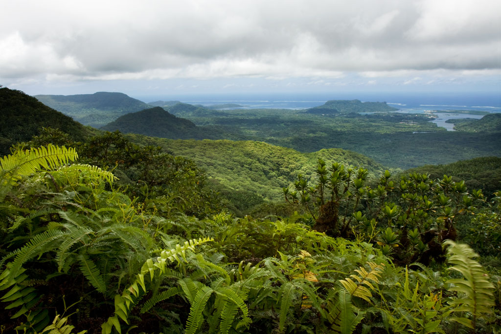
Dolen Nahnsapwe, “hill of thunder,” is a small peak near the Nett–U border. As the crow flies, it’s about 1.3 km (0.8 mi) southwest of the Kupwuriso summit. Though rarely visited and not the highest point in the area, Dolen Nahnsapwe is intriguing because it’s associated with stories about the traditional thunder god, Nahnsapwe, and is said to be the place where thunder storms originate. It’s also the source of the Pwong-Kapwungapwung watercourse, a stream that forms a waterfall below the Lou Rahn ridge in Nett. It’s a challenging climb that follows a trail only part of the way, but the pay-offs come in the form of soaring vistas and gorgeous upland forests. You can approach the peak from either Nett or U or do a full traverse (6.75 km / 4.2 mi) from one side to the other.
Nett Approach
The Nett approach to Dolen Nahnsapwe feels wilder and is steeper and more strenuous. It begins on the side of an unpaved road in Paremkep. The first 0.6 km (0.37 mi) follows the same track that goes to Lou Rahn waterfall and cave with a gentle slope average of about 12%. After that, it branches off and climbs more steeply along the Lou Rahn ridgeline for 2.65 km (1.65 mi) with a slope average ranging between 20% and 25%. This brings hikers to the foot of the peak — a swampy area dominated by thickets of kotop (Clinostigma ponapensis) palms.
U Approach
The way up from U begins behind a cluster of houses at the end of the last road before the Madolenihmw border. On this side, things are much more developed and the trail is clear and well-maintained nearly to the top of the pass north of the peak. One conservation worker told us that sakau farmers from U frequently use this route to access illegal plots in the watershed on the Nett side. The 3.2 km (2 mi) trail meanders through inhabited areas and past a number of a small huts and residences (23% slope avg).
The last bit up to the tiny summit (593 m) is an over-grown, steep (46% slope avg), grubby, and sometimes unnerving scramble from the northwest side. The summit is tiny, and the ground up there has a springy, unstable feel as if you’re actually standing on layers upon layers of ferns and moss rather than solid ground — which may be the case. The effort and unease, however, are rewarded with a truly marvelous 300-degree view. Sokehs Mountain (276 m), Kolonia Town, the open summit of Kupwuriso (630 m), and Dolen Saldenre (629 m) are all visible — weather permitting.
You can do this climb as a day-hike, but a better option is to camp somewhere along the upper Pwong Stream (Pilen Pwong). Remember to pack out everything you packed in. A responsible camp site is one that is invisible once its occupants depart.
- Plan for 8 hours for this hike.
- Please visit the Local Guides & Tour Operators page for a list of experienced guides available for hikes to Dolen Nahnsapwe. Offer $50.00 for a group of five or less.
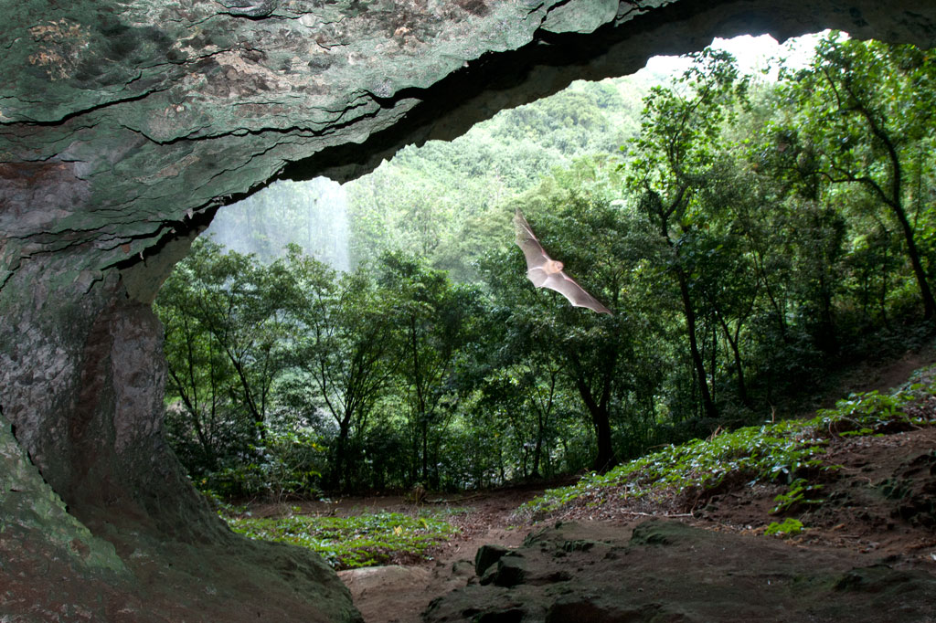
Pahntakai Cave & Waterfall
![]()
![]()
![]()
![]()
![]()
![]()
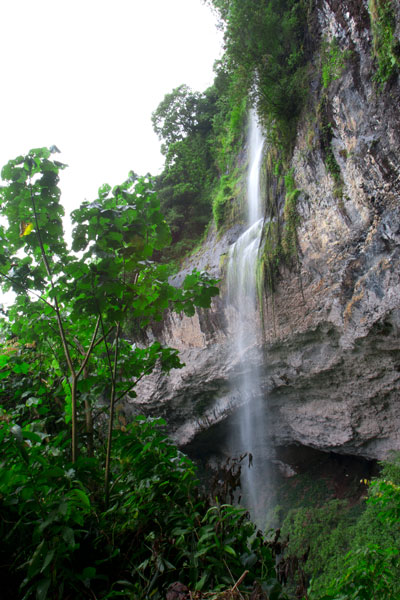
Pahntakai literally means “under the rock” and one visit makes it immediately apparent why this geologically-unique location was given its name. A thin waterfall plummets over a concave cliff-wall more than 30 meters high, which shelters a wide strip of mostly flat ground. You can walk all the way across beneath the cliff to where the ledge widens even more and a small, rocky hill rises up north of the waterfall. Yawning caverns behind the falls host colonies of small insect-eating bats and Caroline Islands Swiftlets that hurry out at dusk to hunt for insects. If you want a closer look, you can climb up through the mounds of guano to the cave openings.
The waterfall itself varies greatly in volume, depending on rain, crashing onto jumbles of rocks below the ledge. It is possible to climb down the slope and stand under the water, but the rocks are slippery and dangerous and there is no pool.
The trail is found at the end of the road and is well-maintained and fairly level most of the way to the cave, skirted by several varieties of sakau (kava) and affording stunning views of the deep gorge below the falls, small huts on the steep hillsides, and the blue sea far out beyond the green of the island. Though you do not need a guide or any special permission to do this hike, the site is private property and the family at the last house on the road charges an entry fee of $3.00 per visitor. Make sure you bear left at the trailhead, rather than taking the path to the right which goes steeply downhill and eventually leads to a house. The hike takes a leisurely 40 minutes round-trip, but Pahntakai is so magical you’ll probably want to hang around and soak up the atmosphere.
Camping
The landowner, Pedro Marvis, permits visitors to camp overnight at Pahntakai, provided they are quiet and respectful of the place and take all their garbage with them afterward. The price per person is the same as when making a day visit — $3.00. The best place to camp is at the northwest end of the trail, where the strip of ground under the cliff is wide and flat. There’s a rock fire-pit there and sometimes some dry firewood left lying around. Because of the overhanging nature of the cliff, things stay dry even during heavy rain. There is one small stream that crosses the main trail about half-way from the trailhead — a good place to filter drinking water if you’re going to stay at Pahntakai a while.
Marine Parks
Nihco Marine Park
Nihco Marine Park, on the southwest coast of scenic Sokehs Bay is an appealing place for people of all ages to swim, barbecue, and soak up the sun. The park is comprised of a narrow, man-made semi-circle of sand with a placid lagoon in the middle where turtles and reef fish are kept. There’s a white-sand beach on the outer edge and simple thatched huts for either day or overnight visits. Small kayaks can be rented for a few dollars. The place can be packed on weekends and holidays.
- To make reservations for day visits, call +691.320.2135 / 4659.
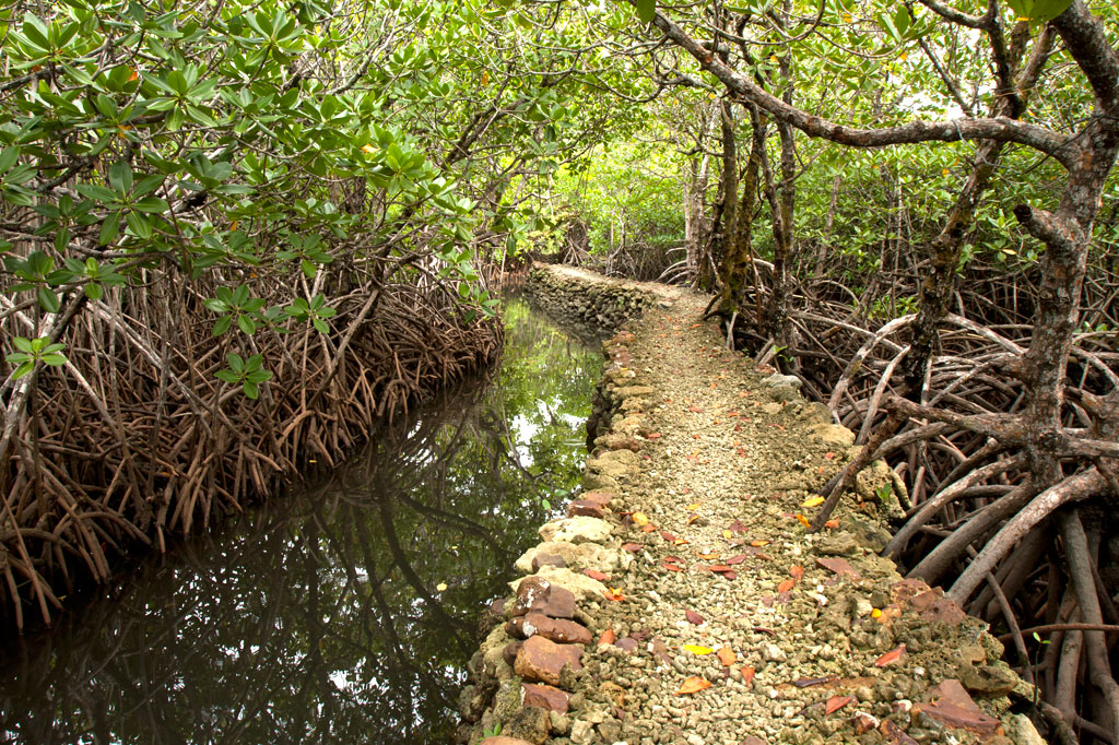
Awak Pah Marine Park
Awak Pah Marine Park is the most well-known of the parks in the area and has a nice big sign right out on the main road. From the parking area near the owner’s house, a 0.2 km (0.12 mi) coral and concrete walkway leads to the water through a dense section of mangrove forests. At the end, there’s a tiny picnic area by the water, a large nahs, and a few other huts that can be rented at an extra cost. The water is shallow and a bit silty on the south side and deep on the west and northwest side where a huge pair of PVC rings have been anchored (a good place to swim). The rock wall by the water is a fun place to jump from, but it can be difficult to climb back out. Snorkeling can be pretty good to the west along the reef wall with lots of small fish and some interesting coral growth. Unfortunately, local visitors have been careless with their garbage and the beautiful reef scenery is frequently ruined by the presence of discarded aluminum soda cans or flashlight batteries — a sad trend on Pohnpei. Water clarity varies from crystal clear to murky depending on the tides; it’s best to visit on an in-coming tide. You can visit Awak Marine Park without making arrangements beforehand.
Paieke Marine Park

This pleasant, breezy swim-picnic-camp park is located on a network of dredged coral causeways that extend out into the lagoon at the point where the road begins to turn east toward the Awak valley. A number of thatched residential huts varying in size and a nahs (meeting hut) or two are positioned around the water’s edge for guests at an extra cost. The swimming is good all along the west side, though the shallows tend to be silty rather than sandy. Snorkelers should follow the edge of the reef further out into the lagoon for best results. The kids will love tinkering around in the shallows under the shady trees. Paieke operates on a reservation-only basis.
- To make reservations for visits call +691.925.0382.
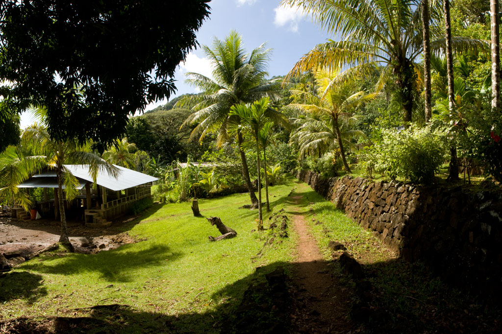
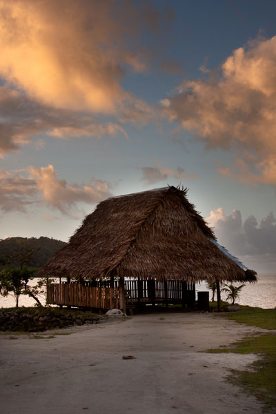
Pein Ahi Marine Park
This charming, but little-known, park (pictured at top) is found just after Awak Marine Park, but as it lacks a sign, most people drive right by without realizing it’s there. From the road, a beautiful 0.16 km (0.1 mi) stone and coral walkway winds through the picturesque mangrove forests and ends at a grassy picnic area with a nahs and a large fish pond. The family keeps some very curious pufferfish and a few other reef fish in the pond, mostly for the amusement of visiting local children. The swimming all around the outside of the pond walls is excellent with consistently good water clarity. There’s a relatively shallow area on the south side that works well for kids or beginning swimmers and deeper water on the west and north. They also have a pair of large bamboo-pontoon rafts that are fun to cruise around the mangrove fringe on. Except on big holidays, you can usually visit without making any prior arrangements.