
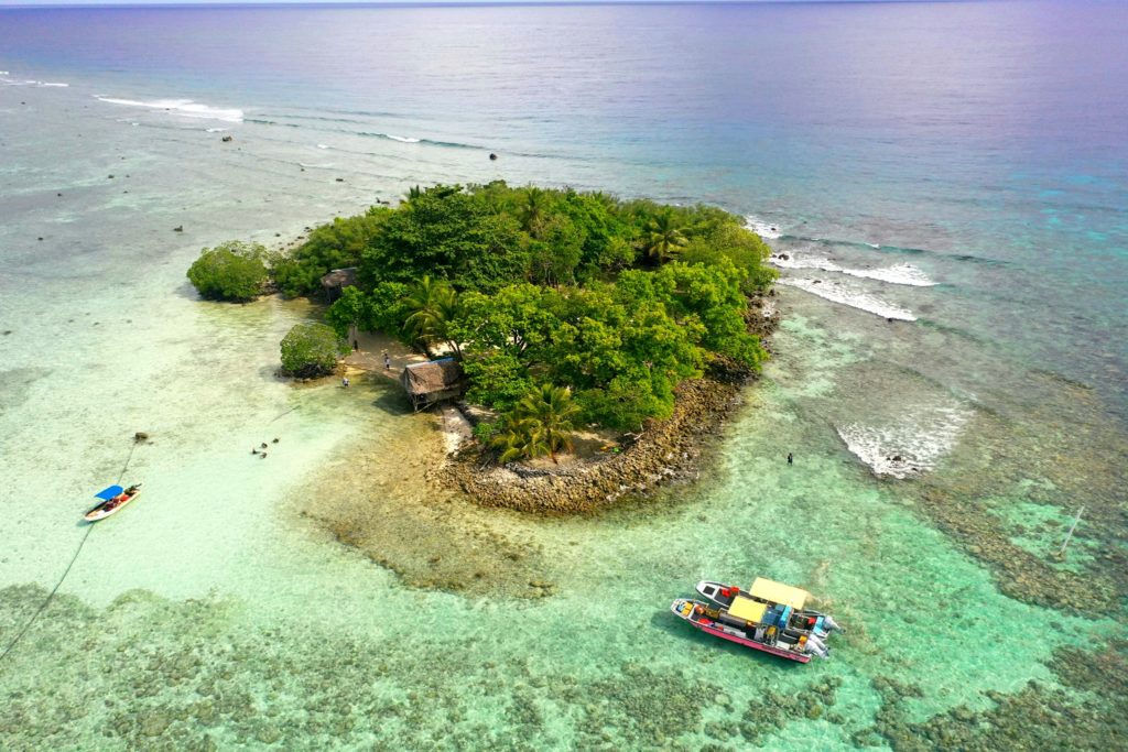
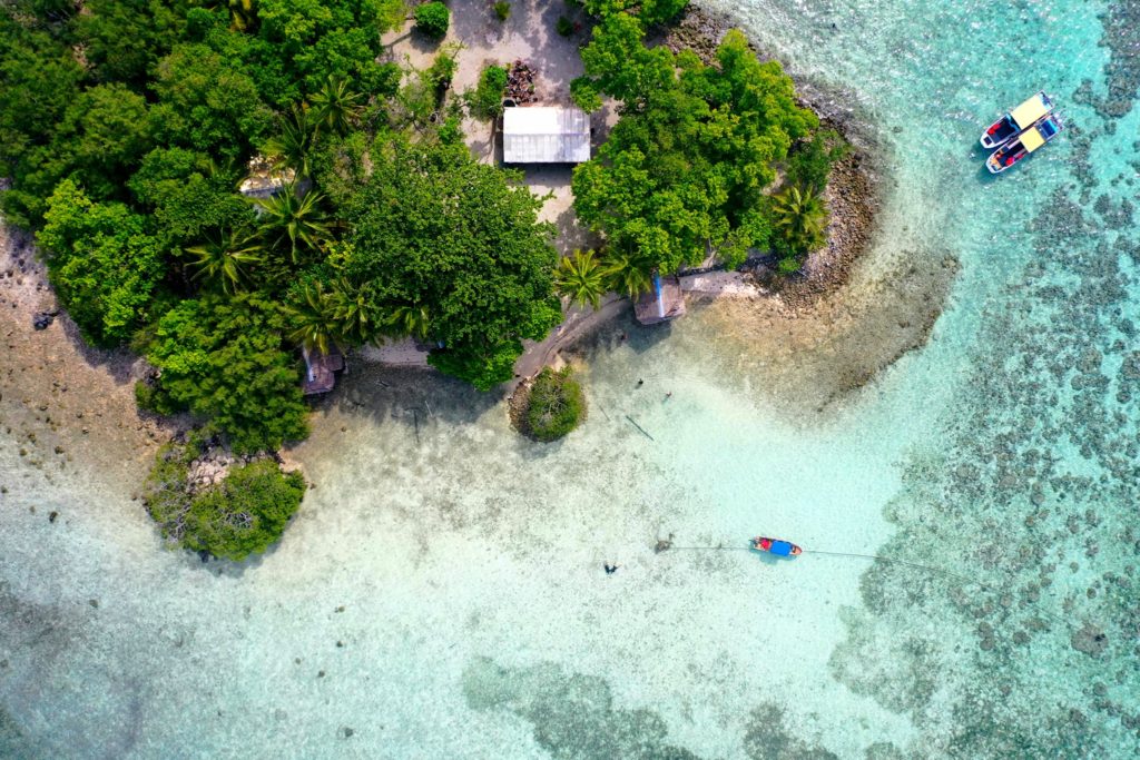
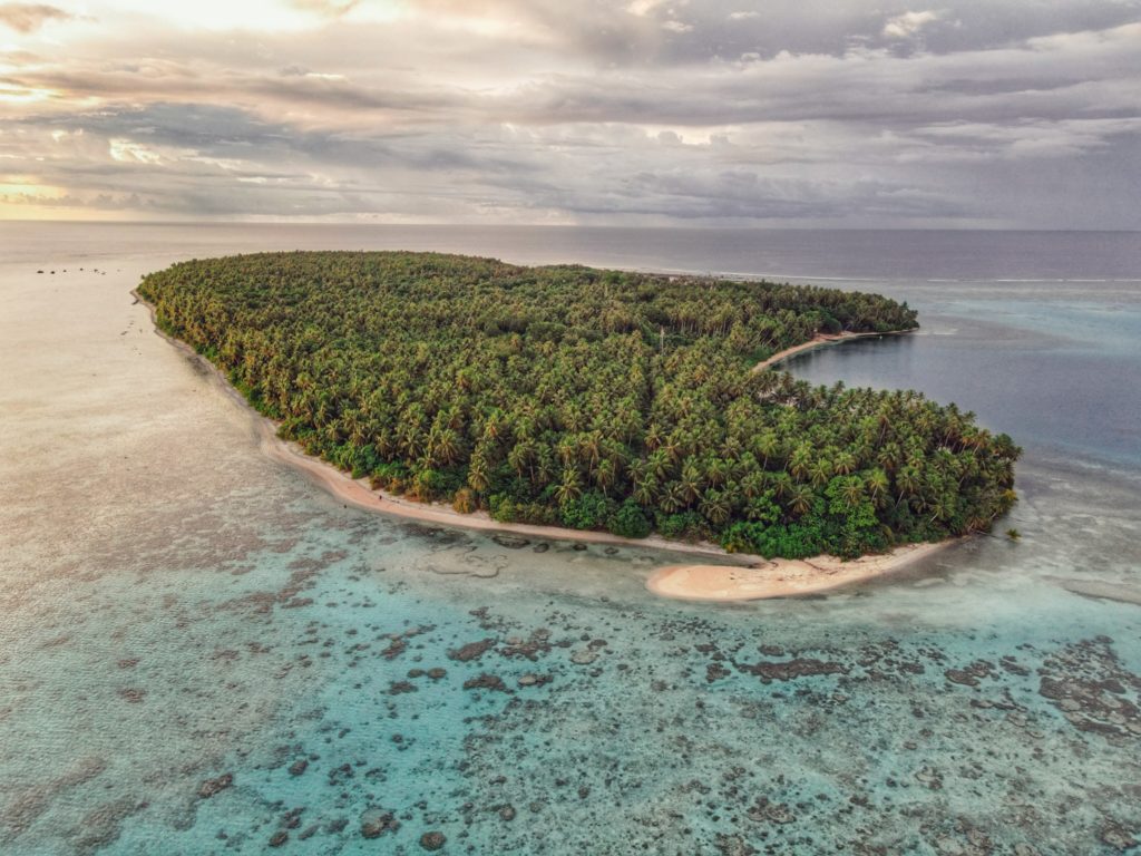
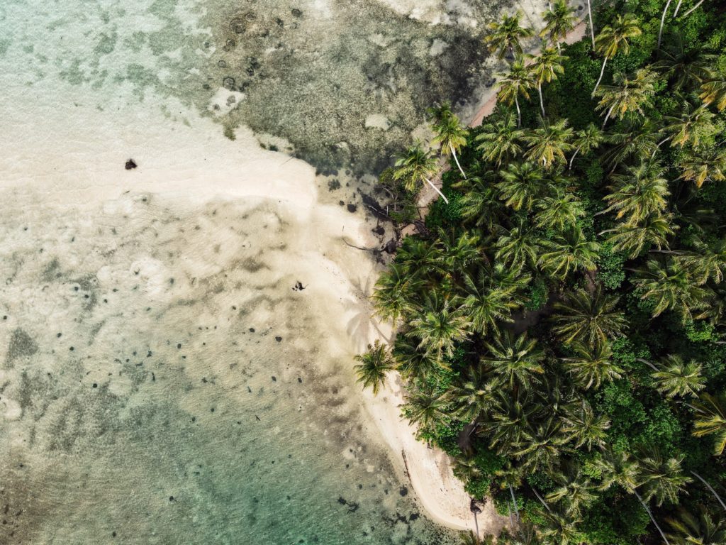
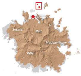
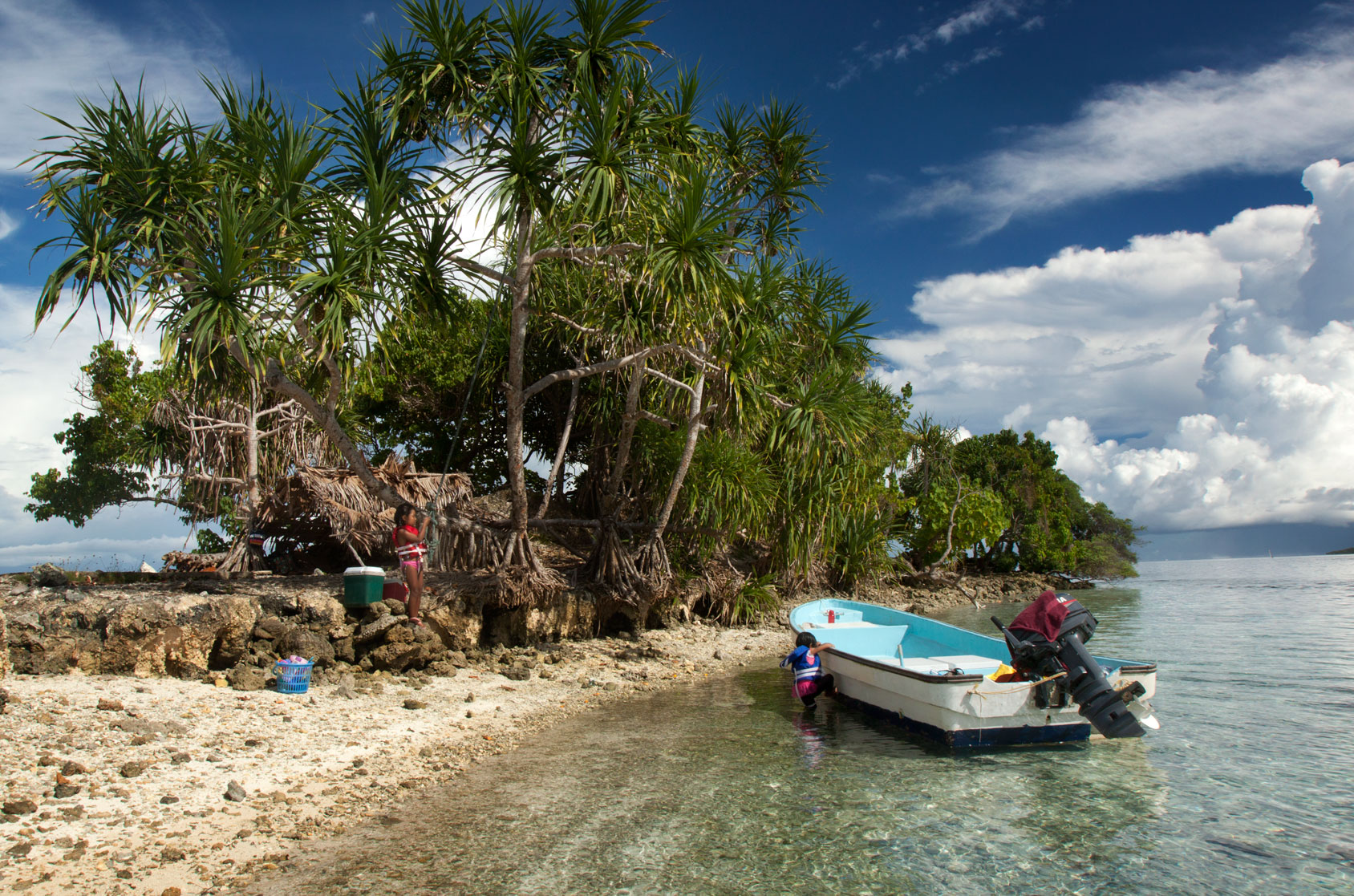
Kehpara Island
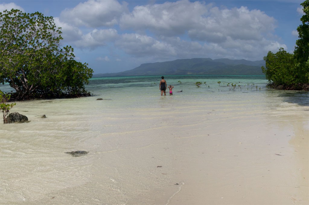
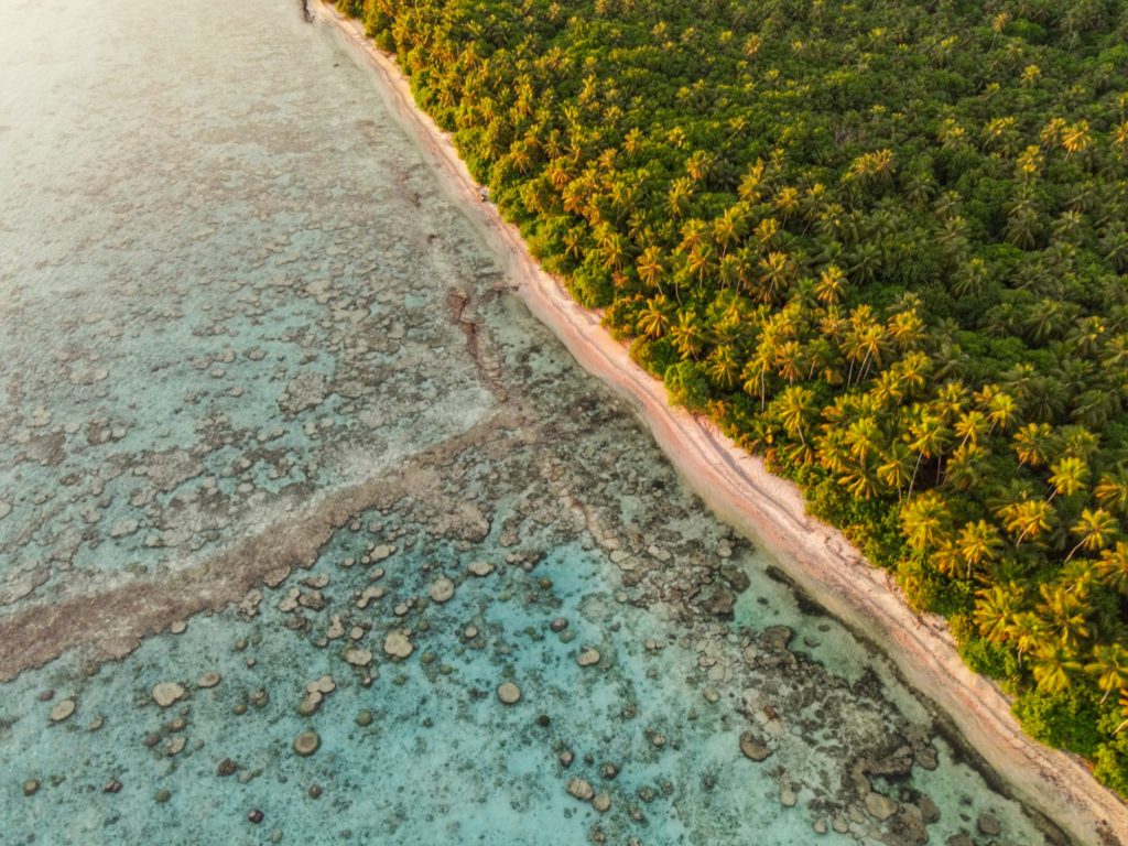
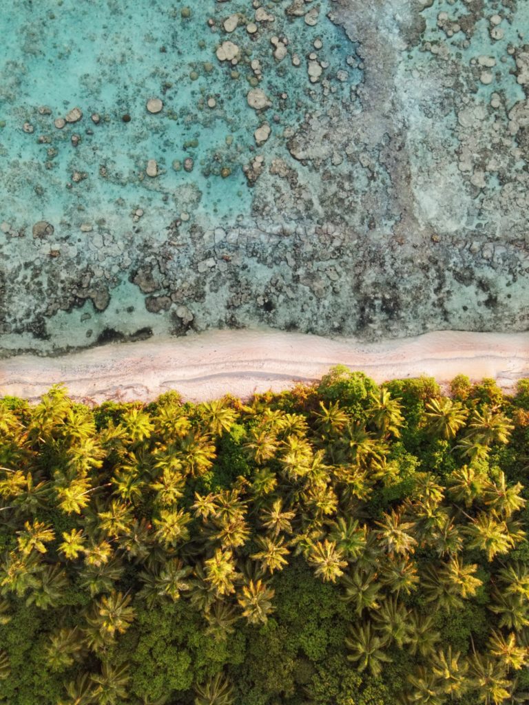
Though not as developed as Black Coral the small thatched huts are adequate for camping trips, the island is equally as shady and much larger than Black Coral, and it actually offers easier access to the excellent snorkeling around Kehpara Pass. It’s cheaper, too. At low tide, there’s a beautiful sandy beach between the two islands. The island has solar lights set up around the island to provide some light at night however we recommend bringing along a lantern and some flashlights to help illuminate inside the huts since they are not rigged with lights.
To make reservations for day visits or overnight stays and arrange for boat pick-up from the launch behind Seinwar Elementary School, call Nickson Abraham (Oaun Kitti) at +691.925.5340 / +691.920.8081 or the Kitti Municipal Government Office at +691.320.5038, 320.5808, 320.5049, or 320.3257.
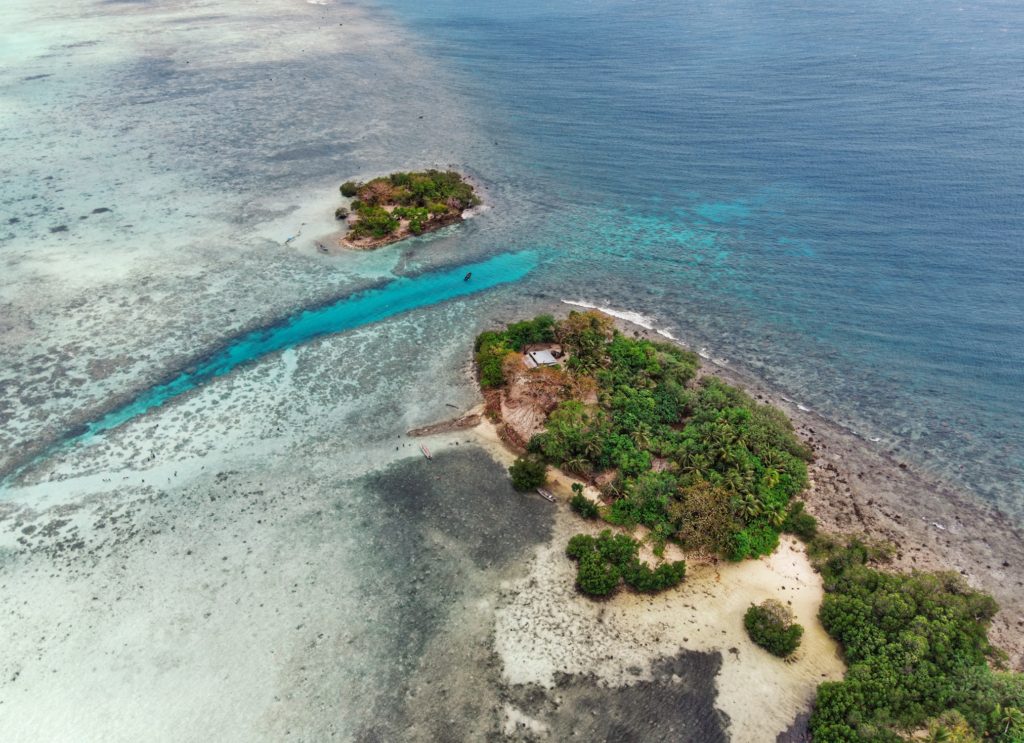
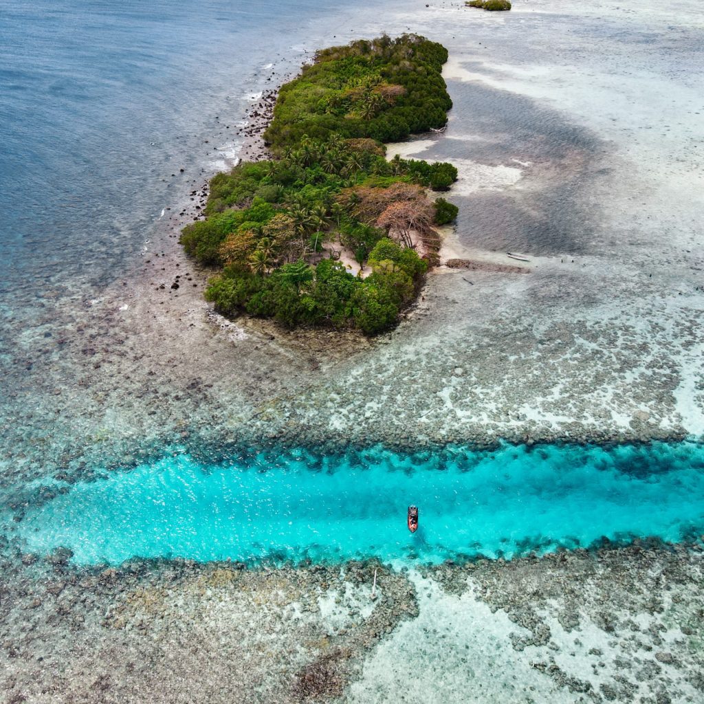
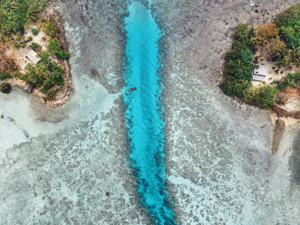

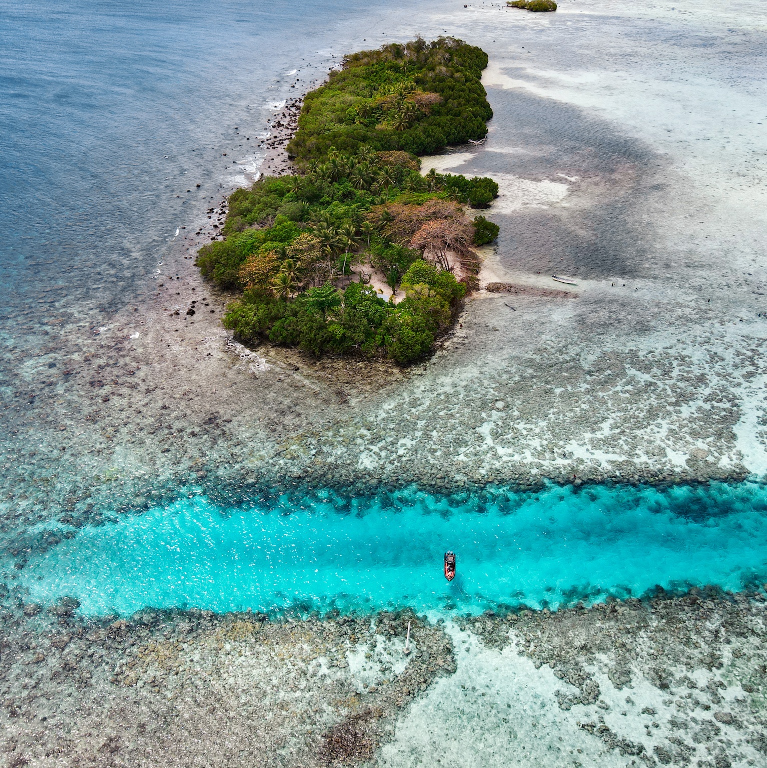
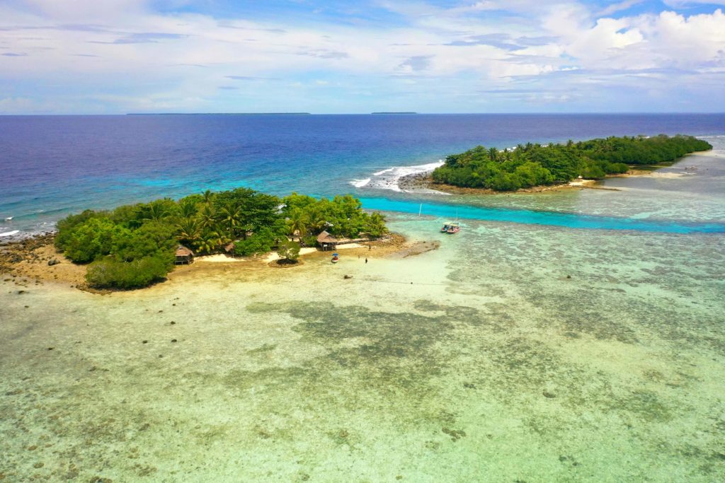
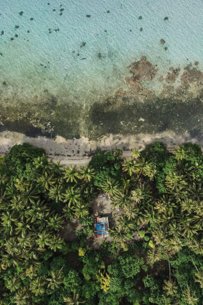
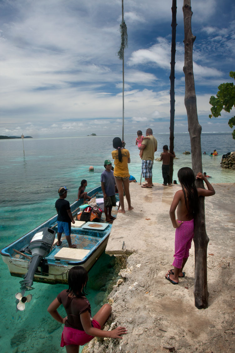
Black Coral Island
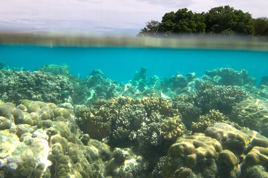
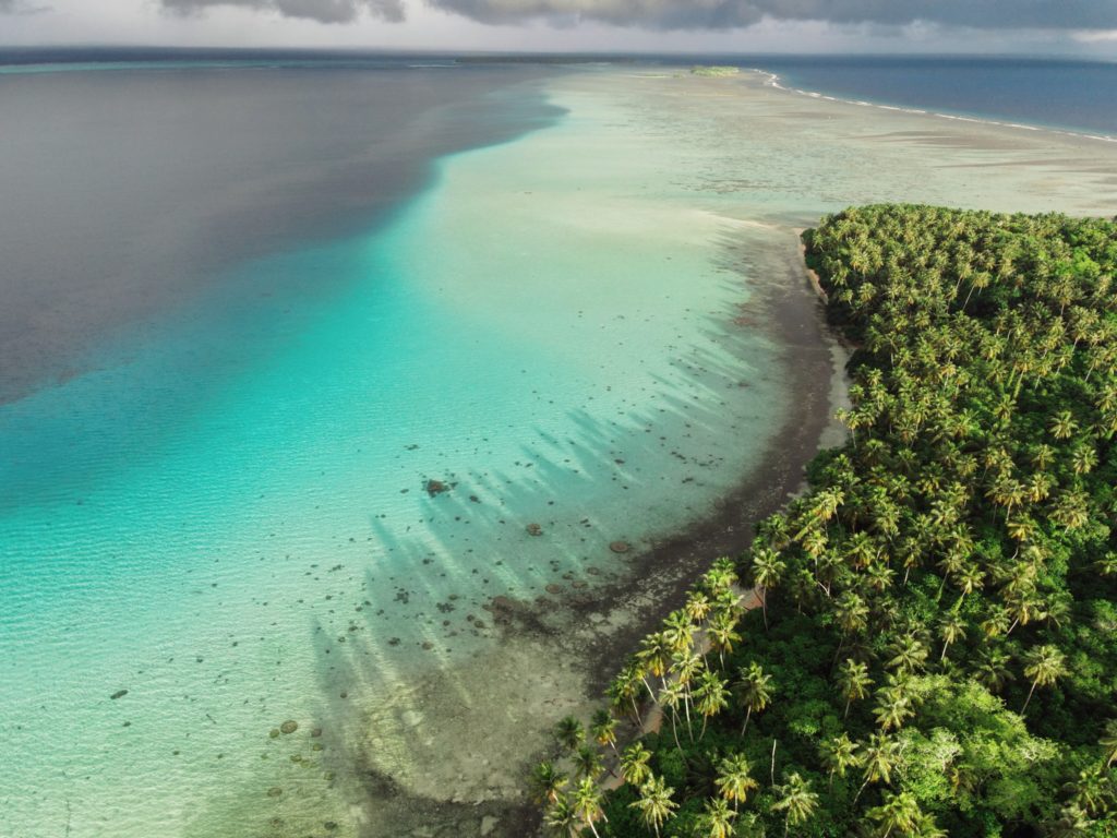
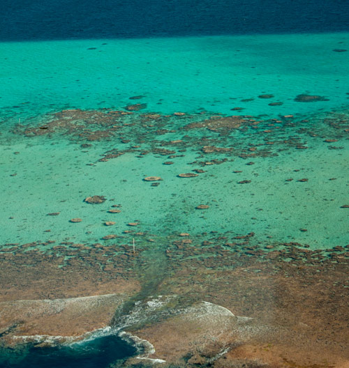
“Black Coral” is the southernmost islet in the Namwmour chain of islands that straddles Kehpara Pass (Dauen Kehpara) on the southwest corner of Pohnpei’s barrier reef. It’s true name is said to be Kehpara, but hardly anyone calls it that. Instead, Kehpara is usually used to refer to the island on the opposite side of the pass (island on lower right side of top image). In the mid-1600s, the conquering hero, Isokelekel, first entered Pohnpei’s barrier reef through Kehpara Pass on his way from Ahnd Atoll to Nan Madol. The sandy and well-shaded coral island, which lies within the Kehpara Marine Protected Area (MPA), is currently owned by the Adams family (the proprietors of Ace Hardware and Ace Office Supply). Black Coral is immaculately maintained with serpentine footpaths running here and there through large sprawling trees and several simple, wooden huts for overnight camping. Good snorkeling is located off the eastern shore and in the pass to the north, where white-tip and black-tip reef sharks, spotted eagle rays, and other marine wonders can often be seen. The best SCUBA diving is along the outer edge of the barrier reef north of the pass, a spot called Kehpara Wall. The area is a spawning ground for several varieties of protected grouper. Though some sandy areas appear at low tide along the inner coast, Black Coral doesn’t have any true beaches.
To make reservations for day visits or night stays and to arrange boat transport from the Seinwar Launch behind Seinwar Elementary School call ACE at +691.320.8279 / 5637.
Ahnd & Pakin Atolls
Pohnpei’s Satellite Atolls
Beyond Pohnpei’s lagoon, the closest land to be found exists on two “satellite atolls” called Ahnd (pronounced änt) and Pakin (pä.keen). An atoll is made up of a number of coralline islets in a ring around a relatively shallow lagoon and is created when a high, volcanic island submerges over millions of years, leaving only the reef that fringed its shores. The islands form as sand, coral rubble, and other detritus collect on the reef and begin to support trees, small plants, and animals. Coral sand accumulates on the lagoon sides of the islands and creates beaches.
")
Ahnd (“Ant”) Atoll
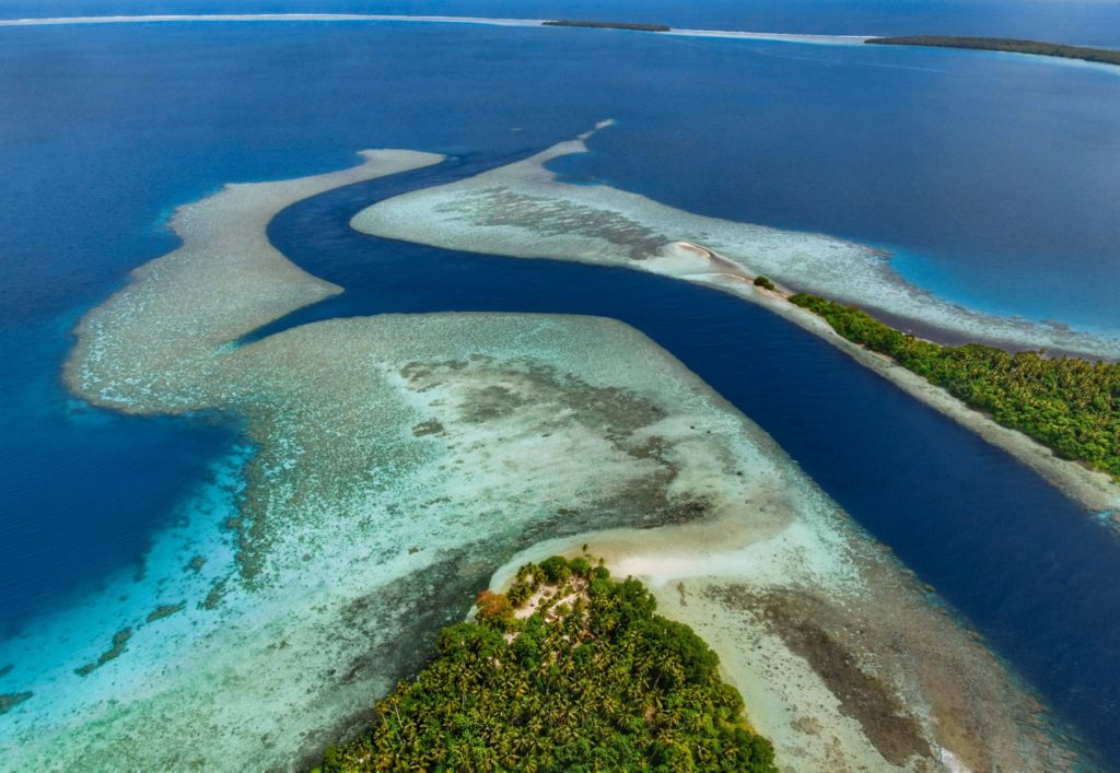
Ahnd Atoll, popularly but erroneously spelled “Ant,” is 16 km (8 mi) southwest of Rohnkitti and consists of 13 low, luxuriant islands 3-4 meters above sea-level and a lagoon of 70 km2 entered by a single passage in the reef.
When the larger-than-life hero Isokelekel voyaged to Pohnpei, intent on overthrowing the rulers of Nan Madol, he came first to Ahnd and lived there for some time, learning about Pohnpeian customs from its inhabitants. In modern times, the entire atoll became the property of a single Pohnpeian family — the descendents of Henry Nanpei, who lived from 1862 to 1928. Nanpei’s shrewd business sense and knack for manipulating local power politics enabled him to acquire the atoll and amass a great deal of other land.
Ahnd Atoll Channel 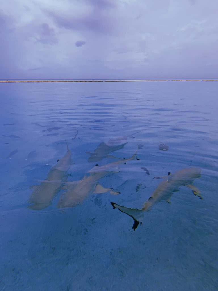
Black tip reef sharks at Ahnd Atoll (PC: Tia Panuelo) 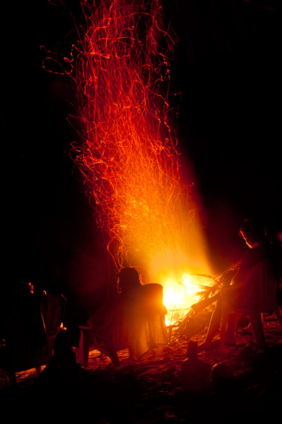
Ahnd Atoll, Federated States of Micronesia (PC: Alex Zuccarelli) 
Ahnd Atoll, Federated States of Micronesia (PC: Alex Zuccarelli) 
Ahnd Atoll, Federated States of Micronesia (PC: Alex Zuccarelli) 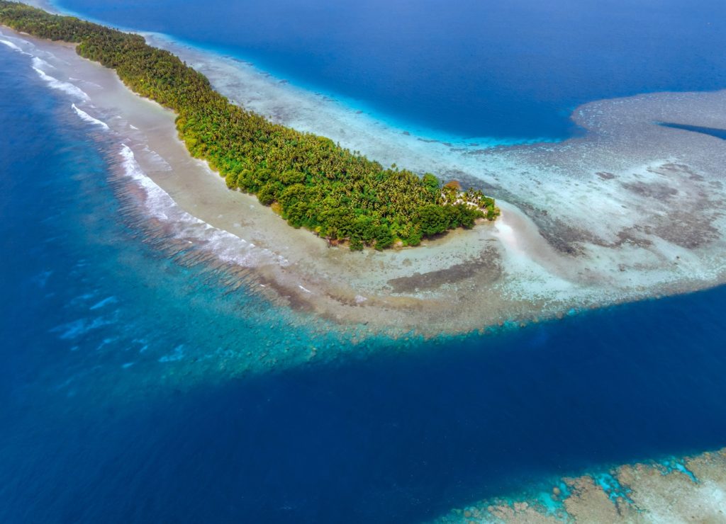
Imwen Sapw Island and channel entrance
Today Ahnd has a few human residents, the biosphere rangers who make sure people do not fish within the protected area. There is also resort run by the Nanpei family located on the island of Pasa (information for booking trips can be found below).
It is home to some of the largest colonies of black noddies, terns, boobies, and frigatebirds in the Pacific as well as a healthy community of gray reef sharks in and around Dauenai (passage).
The most interesting islands to camp on are Pasa, Nikahlap, Dolen Mwuroi, and Nahlos. The former two have long stretches of deserted white-sand beach and excellent swimming. Nan Imwinsapw is closest to Dauenai (passage), where all the best snorkeling and the most accessible diving is found, but it has a big rat problem. Pahn Mwek is near to both excellent snorkeling and some of the rare diving that exists inside the lagoon. For the most part, however, the lagoon is the domain of snorkelers, sandy and punctuated by beautiful coral heads with lots of color and life at low tide.
Dauenai on the south side is where most people go to SCUBA dive. It is known for orange sponges (on the west wall) and large numbers of barracudas, jacks, and sharks throughout. Reef fish populations around the pass, unfortunately, have declined in the last two decades, but hopefully will recover now that the area is protected. Even so, the place still feels busy compared to other locations and you’ll see all the familiar species — unicornfish, triggerfish, wrasses, surgeons, groupers, butterflyfish, angelfish, moorish idols, and more. Moray eels might be spotted on occasion. Spinner dolphins are regularly seen at the mouth of the passage and in the waters around Ahnd. Visibility in the pass, though not as spectacular as outside the reef, can reach 50 meters (164 feet) — certainly nothing to complain about.
In addition to drift-dives on either side of the deep passage, there is stunning (and frequently overlooked) diving on the outer wall of the barrier reef on the northwest side near Olouna (often known as “bird island” for the huge colonies of seabirds that nest there), and north of Pasa. The west wall of the barrier reef plummets to great depths, and because it is more protected from the northeasterly winds and waves, it is marked by an abundance of soft coral, holes, tunnels, and caves — an exciting place for any advanced diver. Giant clams are also common. Visibility on the outside edges can be extraordinary, exceeding 70 meters (230 feet). Currents can be swift both in the pass and around the outer walls.
Visiting Ahnd Atoll / Permission & Protected Areas
Because Ahnd is a privately owned island and UNESCO marine biosphere reserve permission is required from the Nanpei family for visits.
- Contact LP Gas at +691.320.5661 / 2675 to make arrangements.
- You can also book trips to Ahnd Atoll through Pohnpei Surf and Dive Club.
The Tenants of UNESCO Biosphere Reserves
- Core area(s) comprise a strictly protected ecosystem that contributes to the conservation of landscapes, ecosystems, species, and genetic variation.
- A buffer zone surrounds or adjoins the core areas, and is used for activities compatible with sound ecological practices that can reinforce scientific research, monitoring, training, and education.
- The transition area is the part of the reserve where the greatest activity is allowed, fostering economic and human development that is socio-culturally and ecologically sustainable.
Olouna (“Bird Island”)
Landing on Olouna island is prohibited to prevent disruption of the habitats of the seabirds who nest there. If you’d like to take a look at Olouna, consider making a kayak trip around it. You can arrange to pay your boat extra to transport a small ocean kayak or two.
Pakin Atoll
")
Pakin Atoll is composed of about 16 low islands, 13.6 km2 of reef, and a lagoon of 11 km2. It lies 38 km (24 mi) northwest of Palikir. In the early 1900s, Sokehs residents of Mortlockese descent were allowed to settle on the atoll, where their descendents (about 80) live to this day. Most of the islands are sparsely inhabited and all have excellent beaches, swimming, and nearby snorkeling.
One complication of visiting, however, is that Pakin has no true passage, making entry into the lagoon impossible for large boats and both difficult and dangerous for small boats. Boats enter at high tide at one of two places in the barrier reef (the usual spot is known as Uhrek), where the coral is slightly deeper than elsewhere — by a matter of a few inches. ") The crossing is narrow and complicated by strong surge. Except at the highest tides, the crossing must be carefully timed to correspond with the surge. Boats can easily capsize in the surf or be thrown up on the reef; several locals have been killed at the spot while trying to make the crossing in less than ideal conditions. When planning a visit, make sure that you hire an experienced pilot who knows this particular crossing and is committed to the safety of his passengers. Also, it is important to plan arrivals and departures to coincide with the highest tides.
The crossing is narrow and complicated by strong surge. Except at the highest tides, the crossing must be carefully timed to correspond with the surge. Boats can easily capsize in the surf or be thrown up on the reef; several locals have been killed at the spot while trying to make the crossing in less than ideal conditions. When planning a visit, make sure that you hire an experienced pilot who knows this particular crossing and is committed to the safety of his passengers. Also, it is important to plan arrivals and departures to coincide with the highest tides.
All of the diving and the best snorkeling is on the reef wall outside the lagoon, where water clarity and reef conditions are simply mind-blowing. The wall north of Nikahlap is known for sharks, while the opposite side of the island is home to large schools barracuda. For sea turtle sightings, divers will want to try the walls on the northeast side. Turtles nest on many of the small islets north of Painpwel, Sapangin, Kehrot, and Osetik.
Marine Attractions GPS Data
Marine Attractions GPS Data
Downloadable GPS Data Files
The following files contain all the packaged GPS data for each feature or attraction on the Marine Attractions guide.
Three file types are provided. KMZ and KML files are compatible with Google Earth. KML is compatible with Google Maps. GPX files can be imported into ArcGIS (a professional mapping application) and some hand-held GPS devices.
[info]NOTE: All files are free to the public and can be used for any purpose without permission.[/info]
Coastline
These lines were drawn during the course of this project from existing aerial photography and satellite imagery.
- Pohnpei Island Coastline (2013) – KMZ format (284 kb)
- Pohnpei Island Coastline (2013) – KML format (753 kb)
- Pohnpei Island Coastline (2013) – GPX format (1.1 mb)
Mangroves
Including all mangrove forests around Pohnpei Island and its lagoon islands; these lines were drawn during the course of this project from existing aerial photography and satellite imagery.
- Mangrove Forests (2014) – KML format (5.3 mb)
- Mangrove Forests (2014) – KMZ format (1.8 mb)
- Mangrove Forests (2014) – GPX format (7.8 mb)
Reefs
These lines were drawn during the course of this project from existing aerial photography and satellite imagery.
- Pohnpei Island Reef System (2014) – KMZ format (3.2 mb)
- Pohnpei Island Reef System (2014) – KML format (9.1 mb)
- Pohnpei Island Reef System (2014) – GPX format (13.3 mb)
Surf Breaks
Locations were marked based on data provided Pohnpei Surf Club.
- Pohnpei Surf Break Locations (2015) – KMZ format (5 kb)
- Pohnpei Surf Break Locations (2015) – KML format (17 kb)
- Pohnpei Surf Break Locations (2015) – GPX format (11 kb)
SCUBA Diving & Snorkeling
Locations were marked based on data provided by knowledgeable local diving guides and our own on-the-ground data gathering experiences.
- Pohnpei SCUBA Diving & Snorkeling (2014) – KMZ format (50 kb)
- Pohnpei SCUBA Diving & Snorkeling (2014) – KML format (188 kb)
- Pohnpei SCUBA Diving & Snorkeling (2014) – GPX format (179 kb)
Swimming Spots
Locations where poor water quality or environmental contamination make them unsafe for swimming have not been included here. This includes all of the watercourses around Mand, Madolenihmw Municipality (with one exception) and almost everything in Sokehs Municipality. Locations are GPS-verified.
- Swimming Spots (2014) – KMZ format (5 kb)
- Swimming Spots (2014) – KML format (40 kb)
- Swimming Spots (2014) – GPX format (8 kb)
Paddling (Suggested Kayaking, Canoeing & Paddleboarding Routes)
All data was gathered first-hand during this project (all of these routes were paddled); routes are GPS-verified.
- Kayaking & Paddleboarding Routes (2014) – KMZ format (539 kb)
- Kayaking & Paddleboarding Routes (2014) – KML format (1.6 mb)
- Kayaking & Paddleboarding Routes (2014) – GPX format (2.2 mb)
Marine Parks in Awak Pah (2015)
Marine Protected Areas, Mangrove Forest Reserves, and Sanctuaries
Shapes are approximations based on data and maps provided by Conservation Society of Pohnpei (CSP) and were not GPS-verified in the course of this project.
- Pohnpei Marine Protected Areas (2013) – KMZ format (17 kb)
- Pohnpei Marine Protected Areas (2013) – KML format (57 kb)
- Pohnpei Marine Protected Areas (2013) – GPX format (65 kb)
Coordinates
The following coordinates correspond with sites featured on the Marine Attractions Eco-Adventure Map Guide. It is our dream to eventually create a Pohnpei GPS app that could be uploaded to smartphones and other devices, but for now, these points of interest can be entered manually in a hand-held GPS device as needed.
[info]NOTE: All GPS devices have a margin of error. That margin increases with interference — when there is a thick canopy of trees, during bad weather, or when mountains obstruct the satellite link.[/info]
Awak Marine Parks
| Awak Pah MP Entrance | —- | 6.965910° 158.250758° |
| Pein Ahi Entrance | —- | 6.966711° 158.251138° |
| Paieke Entrance | —- | 6.969853° 158.256294° |
| Awak Pah MP Dock | —- | 6.966470° 158.248785° |
| Pein Ahi Fish Pond | —- | 6.967572° 158.249929° |
Temwen Vicinity GPS Data
Downloadable GPS Data Files
The following files contain all the packaged GPS data for each of the featured locations in the Temwen Vicinity Eco-Adventure Map Guide.
Three file types are provided. KMZ and KML files are compatible with Google Earth. KML is compatible with Google Maps. GPX files can be imported into ArcGIS (a professional mapping application) and some hand-held GPS devices.
[info]NOTE: All files are free to the public and can be used for any purpose without permission.[/info]
Temwen Island Coastline (2015)
- Temwen Coastline (2015) – temwen-island.kmz (36 kb)
- Temwen Coastline (2015) – temwen-island.gpx (143 kb)
Temwen Island Mangroves (2015)
- Temwen Mangroves (2015) – temwen-mangroves.kmz (298 kb)
- Temwen Mangroves (2015) – temwen-mangroves.gpx (1.3 mb)
Temwen Island Contour Lines (2015)
- Temwen Island Contour Lines (2015) – temwen-contour.kmz (21 kb)
- Temwen Island Contour Lines (2015) – temwen-contour.gpx (78 kb)
Temwen Island Roads (2015)
- Temwen Island Roads (2015) – temwen-roads.kmz (8 kb)
- Temwen Island Roads (2015) – temwen-roads.gpx (24 kb)
Temwen Island Trails & Routes (2015)
- Temwen Island Trails & Routes (2015) – temwen-routes.kmz (13 kb)
- Temwen Island Trails & Routes (2015) – temwen-routes.gpx (49 kb)
Temwen Island Points of Interest (2015)
- Temwen Island Points of Interest (2015) – temwen-places.kmz (33 kb)
- Temwen Island Points of Interest (2015) – temwen-places.gpx (118 kb)
Dolopwuropwur Gun Battery (2015)
Coordinates
The following coordinates correspond with sites featured on the Temwen Vicinity Eco-Adventure Map Guide. It is our dream to eventually create a Pohnpei GPS app that could be uploaded to smartphones and other devices, but for now, these points of interest can be entered manually in a hand-held GPS device as needed.
[info]NOTE: All GPS devices have a margin of error. That margin increases with interference — when there is a thick canopy of trees, during bad weather, or when mountains obstruct the satellite link. The geosynchronous satellites employed when navigating on Pohnpei are located low on the southwestern horizon, such that maintaining a strong connection while hiking on the northeast side of a given mountain range can be difficult. Coordinates on the northeastern slopes of mountains are less accurate than in other locations.[/info]
Temwen Island
| Temwen Causeway South Bridge | —- | 6.843731° 158.313411° |
| Temwen Causeway North Bridge | —- | 6.845294° 158.314911° |
| Peipas Island (Approx. location) | —- | 6.848979° 158.315855° |
| Salong Point | —- | 6.856344° 158.322675° |
| Temwen Elementary School | —- | 6.851509° 158.329239° |
| Current Nahnmwarki’s Residence | —- | 6.851064° 158.332056° |
| Japanese Wharf | —- | 6.855733° 158.332092° |
| Turn-Off to Nan Madol Trail | —- | 6.846941° 158.328562° |
| Nan Madol Trail Parking | —- | 6.845865° 158.330689° |
| Nan Madol Trailhead | —- | 6.844408° 158.330671° |
| End of Temwen Road / Beginning of Footpath | —- | 6.846342° 158.319744° |
| Causeway Store | —- | 6.845268° 158.314783° |
Nan Madol Ruins
| Nan Madol Trailhead | —- | 6.844408° 158.330671° |
| Peinkitel Perimeter Wall North Corner | —- | 6.844326° 158.331118° |
| Peinkitel Entrance | —- | 6.844018° 158.330501° |
| Peinkitel Tomb | —- | 6.844041° 158.330894° |
| Central Peidoh Islet | —- | 6.844092° 158.331846° |
| Sapwohng Islet West Corner | —- | 6.843660° 158.332228° |
| Huge Tree | —- | 6.843828° 158.333042° |
| Central Peilapalap Islet | —- | 6.842964° 158.332899° |
| Central Rasalap Islet | —- | 6.843384° 158.333474° |
| Central Pahseid Islet | —- | 6.843888° 158.333827° |
| Central Usendau Islet | —- | 6.844284° 158.334102° |
| Central Dau Islet | —- | 6.844609° 158.335067° |
| Nan Douwas Islet Entrance | —- | 6.844533° 158.335524° |
| Nan Douwas Islet Sakau Stones | —- | 6.844560° 158.335479° |
| Nan Douwas Islet Sakau Stone | —- | 6.844547° 158.335663° |
| Nan Douwas Islet Central Tomb | —- | 6.844535° 158.335799° |
| Nan Douwas Islet North Tomb | —- | 6.844698° 158.335777° |
| Nan Douwas Islet South Tomb | —- | 6.844390° 158.335724° |
| Central Pohn Douwas Islet | —- | 6.845042° 158.335810° |
| Central Kohnderek Islet | —- | 6.845558° 158.335205° |
| Central Pwalahng Islet | —- | 6.845051° 158.334678° |
| Kahnimweiso Gate (approx.) | —- | 6.843599° 158.337261° |
| Nan Mwoluhsei Sea-wall Entrance | —- | 6.844190° 158.336966° |
| Central Peikapw Sapwawas Islet | —- | 6.843553° 158.334780° |
| Central Pwilak Islet | —- | 6.843159° 158.333909° |
| Central Peinior Islet | —- | 6.842824° 158.334263° |
| Peinering Islet Entrance | —- | 6.842123° 158.333784° |
| Central Perektuhke Islet | —- | 6.841853° 158.332661° |
| Central Pahn Katau Islet | —- | 6.841491° 158.332450° |
| Central Dapahu Islet | —- | 6.842452° 158.332358° |
| Central Usennamw Islet | —- | 6.842585° 158.331411° |
| Central Peitaup Islet | —- | 6.841846° 158.331174° |
| Central Dekehtik Islet | —- | 6.841530° 158.331148° |
| Dorong Islet Perimeter Wall North Corner | —- | 6.840986° 158.329394° |
| Lehnkei (Pool) | —- | 6.840853° 158.331381° |
| Central Peikapw Islet | —- | 6.841907° 158.330170° |
| Idehd Islet Northwest Entrance | —- | 6.841308° 158.330293° |
| Dolen Idehd / Midden | —- | 6.841081° 158.330336° |
| Nan Samwol’s Hole, Idehd | —- | 6.841252° 158.330532° |
| Idehd Islet Northeast Entrance | —- | 6.841288° 158.330555° |
| Isokelekel’s Slingstones, Idehd | —- | 6.841194° 158.330428° |
| Pahn Kadira Islet Sokehs Corner | —- | 6.841195° 158.329971° |
| Pahn Kadira Islet Katau Corner | —- | 6.840766° 158.329374° |
| Pahn Kadira Islet House Foundation | —- | 6.840986° 158.329394° |
| Temple of Nankieilmwahu, Pahn Kadira | —- | 6.841427° 158.329366° |
| Saudeleur’s House Foundation, Pahn Kadira | —- | 6.841484° 158.328948° |
| Pahn Kadira Islet Southwest Entrance | —- | 6.841074° 158.329119° |
| Pahn Kadira Islet Sakau Stone | —- | 6.841186° 158.329195° |
| Pahn Kadira Islet Sakau Stone | —- | 6.841220° 158.329145° |
| Pahn Kadira Islet Sakau Stone | —- | 6.841266° 158.329161° |
| Pahn Kadira Islet Sakau Stone | —- | 6.841305° 158.329112° |
| Pahn Kadira Islet Sakau Stone | —- | 6.841333° 158.329119° |
| Pahn Kadira Islet Madolenihmw (Likapwar) Corner | —- | 6.841558° 158.328740° |
| Pahn Kadira Islet Kitti Corner | —- | 6.842035° 158.329364° |
| Saudeleur’s Bathing Area, Pahn Kadira | —- | 6.841207° 158.329844° |
| Central Pahn Kadira Islet Annex | —- | 6.841268° 158.328655° |
| Central Wasao Islet | —- | 6.841982° 158.328645° |
| Central Reitik Islet | —- | 6.841565° 158.328299° |
| Central Peilam Islet | —- | 6.840527° 158.328599° |
| Central Kelepwel Islet | —- | 6.840592° 158.329081° |
| Central Peinmwek Islet | —- | 6.840670° 158.329624° |
| Central Palakapw Islet | —- | 6.840433° 158.330480° |
| Central Pohnkeimw Islet | —- | 6.840469° 158.326021° |
| Mweiden Kitti (Opening) | —- | 6.839358° 158.327282° |
| Central Pahnmweid Islet | —- | 6.839566° 158.326991° |
| Central Mweid Islet | —- | 6.838856° 158.327817° |
| Boulder Wall, Pahnwi Islet | —- | 6.837491° 158.328793° |
| Upper Pahnwi Islet | —- | 6.838243° 158.329723° |
| Mweiden Weliwel (Opening) | —- | 6.838459° 158.330260° |
| Kepinehd Islet | —- | 6.838917° 158.330884° |
| Mweiden Nahnsapwe (Opening) | —- | 6.839264° 158.331517° |
| Pikalap Islet | —- | 6.839387° 158.331645° |
| Mweidalap (Opening) | —- | 6.839462° 158.331846° |
| Lemensai Islet | —- | 6.839657° 158.331986° |
| Namwenkau (Pool) | —- | 6.839964° 158.332334° |
| Central Lemenkau Islet & Sakau Stones | —- | 6.840380° 158.332956° |
| Lemenkau Islet West Entrance | —- | 6.840332° 158.332482° |
| Pahn Mwasangapw Burial Chamber | —- | 6.841272° 158.334303° |
| Angeir Burial Chamber | —- | 6.841597° 158.334853° |
| Sapwuhtik Burial Chamber | —- | 6.841978° 158.335596° |
| Lukepen Kerian | —- | 6.842601° 158.336477° |
| Kerian Islet Southwest Entrance | —- | 6.842727° 158.336632° |
| Kerian Islet Central Tomb | —- | 6.842821° 158.336771° |
| Kerian Islet North Tomb | —- | 6.842859° 158.336748° |
| Kerian Islet South Tomb | —- | 6.842776° 158.336799° |
| Barge Wreck, Kerian | —- | 6.842461° 158.336651° |
| Huge Sakau Stone, Kerian | —- | 6.842687° 158.336623° |
Dolopwuropwur Battery
| Turn-off to Dolopwuropwur Trailhead | —- | 6.850746° 158.329126° |
| Dolopwuropwur Trailhead | —- | 6.848025° 158.325991° |
| 15 cm Gun #1 | —- | 6.849032° 158.325672° |
| 15 cm Gun #2 | —- | 6.848915° 158.325796° |
| 15 cm Gun #3 | —- | 6.848777° 158.325841° |
| 15 cm Gun #4 | —- | 6.848569° 158.325807° |
| Northern Ammunition Magazine | —- | 6.848901° 158.325669° |
| Southern Ammunition Magazine | —- | 6.848668° 158.325755° |
| Unknown Japanese Foundation | —- | 6.848775° 158.325632° |
| Stone Tower Steps | —- | 6.848635° 158.325571° |
| Japanese Stone Tower | —- | 6.848609° 158.325540° |
| Dug-Out | —- | 6.848583° 158.325497° |
| Japanese Trench North End | —- | 6.848767° 158.325589° |
| Japanese Trench Intersection | —- | 6.848156° 158.324919° |
| Unknown Japanese Structure | —- | 6.848138° 158.325148° |
| Japanese Trench South End / Path Intersection | —- | 6.847964° 158.323712° |
| Cross Island Footpath South End | —- | 6.846107° 158.322737° |
| Cross Island Footpath North End | —- | 6.851214° 158.325296° |
| Dolopwuropwur Peak | —- | 6.848742° 158.325911° |
Around Temwen
| Pohnpei Agriculture & Trade School (PATS) | —- | 6.843103° 158.307976° |
| Marine Environmental Research Institute of Pohnpei (MERIP) | —- | 6.843932° 158.308811° |
| MERIP Apartments | —- | 6.843340° 158.308811° |
| Mwudoketik Island | —- | 6.841213° 158.319636° |
| Mwudokalap Island | —- | 6.839816° 158.317841° |
| Ulidei Island | —- | 6.841085° 158.316101° |
| Dauen Moahk (Channel) West End | —- | 6.845671° 158.314698° |
| Dauen Moahk (Channel) East End | —- | 6.840842° 158.328417° |
| Namwen Nahnningi Stingray Reserve | —- | 6.833504° 158.322414° |
| Nahnningi Island | —- | 6.831781° 158.326057° |
| Mall Island | —- | 6.829152° 158.322269° |
| Nahnningi Snorkeling Pool | —- | 6.828426° 158.326448° |
| Nahnningi Dive Site | —- | 6.826786° 158.324659° |
| Straight Wall Dive Site | —- | 6.832236° 158.334271° |
| Pahn Nahkapw Bridge Dive Site | —- | 6.840180° 158.342650° |
| Kepidauen Nahkapw (Reef Passage) | —- | 6.840793° 158.342252° |
| Nahkapw Island | —- | 6.843777° 158.344200° |
| Pahn Nahkapw Wall Dive Site & Snorkeling | —- | 6.843689° 158.342220° |
| Nipaden Nahkapw Snorkeling Spot | —- | 6.846010° 158.346045° |
| Dekehtik Island | —- | 6.848340° 158.348134° |
| Dekehtik Island Snorkeling Spot | —- | 6.847929° 158.346902° |
| Namwen Na Stingray Reserve | —- | 6.853543° 158.352856° |
| Na North Coast Camping, Swimming & Snorkeling | —- | 6.852748° 158.356608° |
| Nahpali Island | —- | 6.861427° 158.355330° |
| Dekehmwahu Island | —- | 6.860339° 158.359588° |
| Nahpali Island Snorkeling | —- | 6.860600° 158.353214° |
| Nahpali Island Searchlight Drum | —- | 6.862617° 158.356630° |
| Nahpali Island Gun Station #3 | —- | 6.862775° 158.356153° |
| Nahpali Island Gun Station #2 | —- | 6.862848° 158.355992° |
| Nahpali Island Gun Station #1 | —- | 6.862914° 158.355861° |
| Nahpali Island Japanes Coastal Foundation | —- | 6.862591° 158.355395° |
| Nahpali Island Beach | —- | 6.862192° 158.354946° |
| Nahpali Island Beach | —- | 6.863028° 158.355964° |
| Nahpali Island Japanese Coastal Foundation | —- | 6.862075° 158.354758° |
| Nahpali Island Japanese Diesel Engine | —- | 6.861961° 158.354814° |
| Nahpali Island Japanese Foundations | —- | 6.861690° 158.354699° |
| Nahpali Island Japanese Foundation | —- | 6.861393° 158.354617° |
| Nahpali Island Japanese Water Tank | —- | 6.861250° 158.354561° |
| Nahpali Island Japanese Coastal Water Tank | —- | 6.861402° 158.354411° |
| Nahpali Island Gateway Tree | —- | 6.861229° 158.354377° |
| Nahpali Island Japanese Cistern | —- | 6.861601° 158.354808° |
| Dekehmwahu Beach | —- | 6.861424° 158.359777° |
| Na Dive Site | —- | 6.846678° 158.365113° |
| Nanwap Corner Dive Site | —- | 6.871079° 158.356093° |
| Kepidauen Deleur (Reef Passage) | —- | 6.863361° 158.343756° |
| Madolenihmw Bay | —- | 6.861248° 158.306274° |
| Nahpali Surf Break | —- | 6.867134° 158.361762° |
| Nan Madol (Kepidauen Nahkapw) Surf Break | —- | 6.839137° 158.340387° |
Lenger Island GPS Data
Downloadable GPS Data Files
The following files contain all the packaged GPS data for the Lenger Island Eco-Adventure Map Guide, including the island’s coastline, ocean depth info, ten meter contour lines, mangrove forests, roads and trails, land divisions, World War II features, modern features, and other points of interest.
Three file types are provided. KMZ and KML files are compatible with Google Earth. KML is compatible with Google Maps. GPX files can be imported into ArcGIS (a professional mapping application) and some hand-held GPS devices.
[info]NOTE: All files are free to the public and can be used for any purpose without permission.[/info]
Lenger Island (2016)
Coordinates
The following coordinates correspond with sites featured on the Lenger Island Eco-Adventure Map Guide. It is our dream to eventually create a Pohnpei GPS app that could be uploaded to smartphones and other devices, but for now, these points of interest can be entered manually in a hand-held GPS device as needed.
[info]NOTE: All GPS devices have a margin of error. That margin increases with interference — when there is a thick canopy of trees, during bad weather, or when mountains obstruct the satellite link. The geosynchronous satellites employed when navigating on Pohnpei are located low on the southwestern horizon, such that maintaining a strong connection while hiking on the northeast side of a given mountain range can be difficult. Coordinates on the northeastern slopes of mountains are less accurate than in other locations.[/info]
Southwestern Lenger
| Barbosa’s Wharf | —- | 6.993799° 158.228531° |
| Former Barbosa Resort Site | —- | 6.994306° 158.229159° |
| Japanese Coastal Warehouse Foundation | —- | 6.994406° 158.229708° |
| Japanese Underground Crude Oil Complex Trailhead | —- | 6.994717° 158.229517° |
| Gate 1 – Crude Oil Complex | —- | 6.995515° 158.230239° |
| Japanese Storage Caves Trailhead | —- | 6.993890° 158.230359° |
| Japanese Concrete Plant Trailhead | —- | 6.994275° 158.230646° |
| Japanese Concrete Plant Equipment | —- | 6.994502° 158.230447° |
| Ballast Hill | —- | 6.994418° 158.230380° |
| Japanese Cave 1 | —- | 6.994567° 158.231047° |
| Japanese Cave 2 | —- | 6.994792° 158.230931° |
| Japanese Cave 3 | —- | 6.994894° 158.230736° |
| Japanese Cave 4 | —- | 6.994950° 158.230661° |
| Japanese Above-Ground Oil Tank | —- | 6.993772° 158.230847° |
| Japanese Above-Ground Oil Tank Foundation | —- | 6.993894° 158.230716° |
| Path Intersection Point | —- | 6.993445° 158.230835° |
Southern Lenger
| Japanese Machine Parts | —- | 6.993100° 158.231317° |
| Japanese Square Cistern | —- | 6.993406° 158.231139° |
| Japanese Aviation Fuel Tank Trailhead | —- | 6.993896° 158.231492° |
| Japanese Aviation Fuel Tank Tunnel Gate | —- | 6.994211° 158.231342° |
| Japanese Rectangular Cistern | —- | 6.994006° 158.231840° |
| Japanese Machinery & Wheels | —- | 6.993628° 158.231561° |
Eastern Lenger
| Stream Crossing | —- | 6.995612° 158.232389° |
| Banyan Wheel | —- | 6.996089° 158.232106° |
| Dolen Lenger Trailhead (Eastern Route) | —- | 6.995896° 158.232360° |
Northeastern Lenger
| Japanese Seaplane Hangar Ruin | —- | 6.997648° 158.232069° |
| Compressor | —- | 6.997654° 158.232009° |
| Japanese Seaplane Strut | —- | 6.997610° 158.231969° |
| Japanese Seaplane Engine & Prop | —- | 6.997646° 158.231922° |
| Japanese Seaplane Carriers | —- | 6.997317° 158.231503° |
| Japanese Seaplane Ramp Trailhead | —- | 6.998005° 158.231864° |
| Japanese Seaplane Ramp | —- | 6.999088° 158.233040° |
Northern Lenger
| Well | —- | 6.998180° 158.231401° |
| Bomb Craters | —- | 6.998240° 158.230883° |
Western Lenger
| Japanese Coastal Barracks Site | —- | 6.996593° 158.228989° |
| Japanese Coastal Barracks Site | —- | 6.997418° 158.228861° |
| Dolen Lenger Trailhead Western Route A | —- | 6.997555° 158.229206° |
| Dolen Lenger Trailhead Western Route B | —- | 6.997874° 158.229242° |
Central Lenger (Hill Area)
| Intersection of Japanese Hill Roads | —- | 6.997592° 158.230367° |
| Tunnel Entrance | —- | 6.997431° 158.230122° |
| Japanese Dug-out 1 | —- | 6.997294° 158.230053° |
| Japanese Dug-out 2 | —- | 6.997325° 158.230153° |
| Japanese Gatepost | —- | 6.997197° 158.230789° |
| Dolen Lenger Japanese Cistern 1 | —- | 6.996967° 158.230894° |
| Cement Steps | —- | 6.996908° 158.230919° |
| Japanese Coastal Battery Trailhead | —- | 6.996659° 158.230743° |
| 15-cm Gun Station 3 | —- | 6.996673° 158.230400° |
| 15-cm Gun Station 4 | —- | 6.996549° 158.230341° |
| 15-cm Gun 4 | —- | 6.996589° 158.230353° |
| Japanese Heavy Ordnance Magazine | —- | 6.996374° 158.230300° |
| Japanese Searchlight Drum | —- | 6.996547° 158.230692° |
| Searchlight Mount | —- | 6.996547° 158.230644° |
| Well | —- | 6.996164° 158.230914° |
| Small Japanese Gun Station | —- | 6.996278° 158.230736° |
| Japanese Anti-Aircraft Gun Station 1 | —- | 6.996000° 158.230706° |
| Cliff-Top Viewpoint | —- | 6.995681° 158.230625° |
| Japanese Anti-Aircraft Gun Station 2 | —- | 6.995547° 158.230878° |
| Cliff-top Viewpoint | —- | 6.995256° 158.231036° |
| Dolen Lenger Summit | —- | 6.995211° 158.231133° |
| Tunnel Entrance | —- | 6.996831° 158.230875° |
| Japanese Hillslope Barracks Foundations | —- | 6.996666° 158.231196° |
| Dolen Lenger Japanese Cistern | —- | 6.996650° 158.231408° |
| Japanese Diesel Engines | —- | 6.996544° 158.231369° |
| Japanese Catchments | —- | 6.996519° 158.231397° |
Around Lenger Island
| Mangrove Channel – North End | —- | 6.994655° 158.233077° |
| Mangrove Channel – South End | —- | 6.992055° 158.232919° |
| Kohatsu Wharf Ruin | —- | 6.991614° 158.232224° |
| Jaluit Cistern | —- | 6.994608° 158.227631° |
Central Sapwtik
| Sapwtik Island Japanese Wharf | —- | 7.002000° 158.223916° |
| Coastal Path Intersection Point | —- | 7.004462° 158.224978° |
| Ascent to Dolen Sapwtik | —- | 7.004270° 158.225460° |
| Japanese Hilltop Wall | —- | 7.004401° 158.225972° |
| Dolen Sapwtik Summit | —- | 7.004317° 158.226247° |
| Japanese Hilltop Foundation 1 | —- | 7.004372° 158.226264° |
| Japanese Hilltop Foundation 2 | —- | 7.004531° 158.226044° |
| Japanese Hilltop Foundation 3 | —- | 7.004643° 158.225894° |
| Great Banyan | —- | 7.004788° 158.225917° |
| Japanese Hilltop Cistern 1 | —- | 7.004421° 158.226434° |
| Japanese Hilltop Cistern 2 | —- | 7.004567° 158.226193° |
Western Sapwtik
| Japanese Heavy Ordnance Magazine | —- | 7.005594° 158.224468° |
| Japanese Coastal Gun Station 1 | —- | 7.005850° 158.224329° |
| Japanese Coastal Gun Station 2 | —- | 7.005976° 158.224384° |
| Japanese Coastal Gun Station 3 | —- | 7.006085° 158.224460° |
| Japanese Coastal Gun Station 4 | —- | 7.006203° 158.224497° |
Northern Sapwtik
| Japanese Hillside Rifle Pit | —- | 7.005679° 158.224880° |
Lepin Dau Island
This island is claimed by the same family as Dahu Reirei and has no true name, but as it lies adjacent to the primary channel every boat in the area uses to go from Areu and Ohwa to Madolenihmw Bay, it’s known by most people as Lepin Dau (or sometimes “Channel Island”). Lepin Dau is larger and higher than Dahu Reirei and has some welcoming tree-cover. The reef pass on the west side is a nice spot to snorkel at slack tide, but at other times, the current can be so strong that snorkelers and swimmers run a strong risk of being swept away. A better spot for snorkeling is in the blue holes around the southeast side — well out of the path of the current. Here you can find beautiful coral grottoes, schools of needlefish, barracuda, cuttlefish, trumpetfish, angelfish, and parrotfish, an odd seasnake (the latter are venomous, but so passive that they pose little danger to snorkelers), and from time to time even eagle rays and small green turtles.
- To obtain permission for overnight stays or to arrange boat transport from Ninleu, call +691.924.2229.
Dekehmwahu Island
Uninhabited little Dekehmwahu (“good island”) is located just east of Nahpali in Madolenihmw Municipality. It’s a rough oval with a couple of small, sandy beaches and a few places to pitch a tent. The best beach is at the northwestern end, while the most practical camp site is on the southeast coast. Mangroves skirt most of the western coast. With a few exceptions, the surrounding ocean is shallow and covered with beds of seagrass, but good snorkeling can be found not far to the south at the Namwen Na Stingray Sanctuary (a short swim away). Surrounding shallow reefs make the island difficult to reach by boat, except at the highest tides, but it’s a great place for kayakers to visit. Currents can be extremely strong in the area at certain times.
- To obtain permission for overnight stays, call McKenzie Senda at +691.320.8682 / 7147 / 4062.
Dau Reirei Island
Dahu Reirei (“long channel”) is a long, narrow, man-made islet constructed on a shallow reef with several huts for picnickers and campers and lots of pleasant swimming and snorkeling nearby. The tiny place can get uncomfortably crowded on weekends and holidays, but is wonderful at other times. One of Dahu Reirei‘s biggest draws is its namesake — the crystal-clear channel along the west side, which is host to many varieties of staghorn coral and swarms of reef fish; it’s a magical place to swim. The reef walls north of the island, however, are better for snorkeling (follow the reef as it curves east and north). Note that Dahu Reirei is really about being IN the water as the island itself isn’t much of anything. And in the water is exactly where you’ll want to be when the temperatures soar (there is little shade) and when the land shrinks at high tide (the island is hardly a meter above sea level). The family of the owner lives in a stilt-hut at the north end of the island.
- To make reservations for day visits or overnight stays and to arrange boat transport from Ninleu, call +691.924.2229. There is an admission fee for the island so be sure to ask for quote if you would like to book a trip.
Marine Parks
Nihco Marine Park
Nihco Marine Park, on the southwest coast of scenic Sokehs Bay is an appealing place for people of all ages to swim, barbecue, and soak up the sun. The park is comprised of a narrow, man-made semi-circle of sand with a placid lagoon in the middle where turtles and reef fish are kept. There’s a white-sand beach on the outer edge and simple thatched huts for either day or overnight visits. Small kayaks can be rented for a few dollars. The place can be packed on weekends and holidays.
- To make reservations for day visits, call +691.320.2135 / 4659.
Awak Pah Marine Park
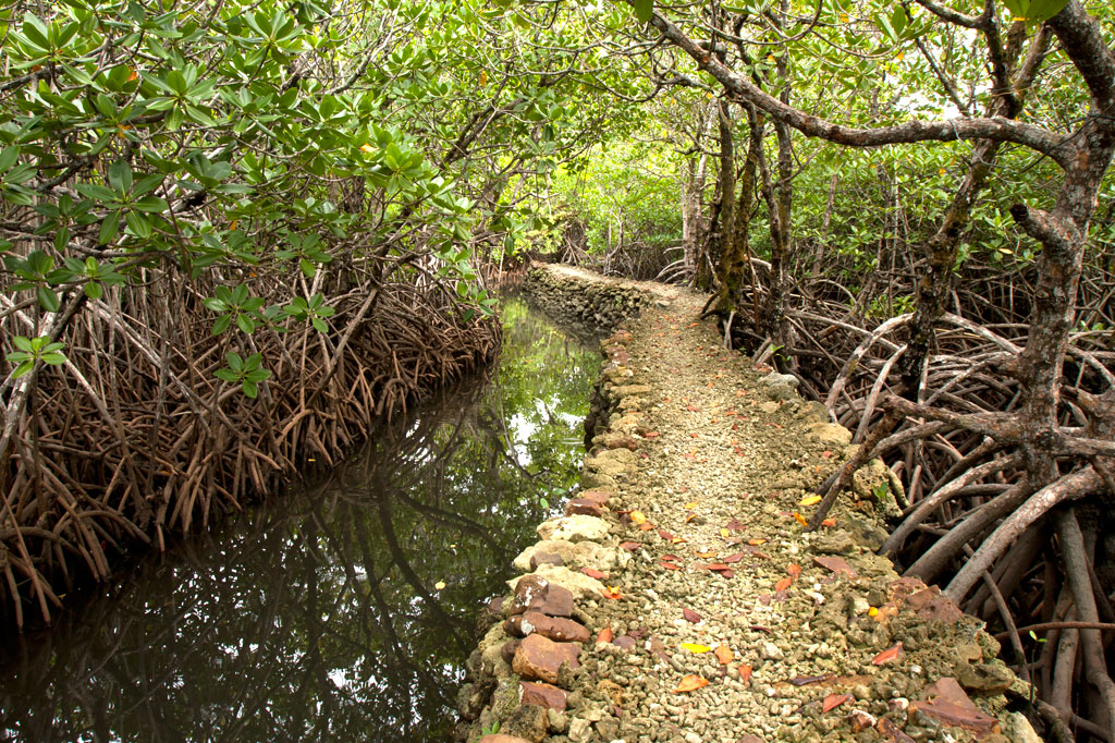
Awak Pah Marine Park is the most well-known of the parks in the area and has a nice big sign right out on the main road. From the parking area near the owner’s house, a 0.2 km (0.12 mi) coral and concrete walkway leads to the water through a dense section of mangrove forests. At the end, there’s a tiny picnic area by the water, a large nahs, and a few other huts that can be rented at an extra cost. The water is shallow and a bit silty on the south side and deep on the west and northwest side where a huge pair of PVC rings have been anchored (a good place to swim). The rock wall by the water is a fun place to jump from, but it can be difficult to climb back out. Snorkeling can be pretty good to the west along the reef wall with lots of small fish and some interesting coral growth. Unfortunately, local visitors have been careless with their garbage and the beautiful reef scenery is frequently ruined by the presence of discarded aluminum soda cans or flashlight batteries — a sad trend on Pohnpei. Water clarity varies from crystal clear to murky depending on the tides; it’s best to visit on an in-coming tide. You can visit Awak Marine Park without making arrangements beforehand.
Paieke Marine Park

This pleasant, breezy swim-picnic-camp park is located on a network of dredged coral causeways that extend out into the lagoon at the point where the road begins to turn east toward the Awak valley. A number of thatched residential huts varying in size and a nahs (meeting hut) or two are positioned around the water’s edge for guests at an extra cost. The swimming is good all along the west side, though the shallows tend to be silty rather than sandy. Snorkelers should follow the edge of the reef further out into the lagoon for best results. The kids will love tinkering around in the shallows under the shady trees. Paieke operates on a reservation-only basis.
- To make reservations for visits call +691.925.0382.
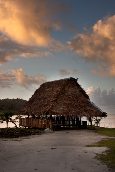
Pein Ahi Marine Park
This charming, but little-known, park (pictured at top) is found just after Awak Marine Park, but as it lacks a sign, most people drive right by without realizing it’s there. From the road, a beautiful 0.16 km (0.1 mi) stone and coral walkway winds through the picturesque mangrove forests and ends at a grassy picnic area with a nahs and a large fish pond. The family keeps some very curious pufferfish and a few other reef fish in the pond, mostly for the amusement of visiting local children. The swimming all around the outside of the pond walls is excellent with consistently good water clarity. There’s a relatively shallow area on the south side that works well for kids or beginning swimmers and deeper water on the west and north. They also have a pair of large bamboo-pontoon rafts that are fun to cruise around the mangrove fringe on. Except on big holidays, you can usually visit without making any prior arrangements.