
Temwetemwensekir Peak
Southeast of Palikir, Pohnpei’s primary mountain system makes an almost 90° turn to the south at Temwetemwensekir (594 m), a prominent peak that dominates the topography and feeds six major rivers. The all-day slog to the top begins up an unpaved road opposite the College of Micronesia national campus. Though the route isn’t always clear and the challenge of the climb is increased by rough terrain and a few steep pitches, once one reaches the palm forests on the ridge, it’s smooth sailing. Hikers are afforded some beautiful views of Nanpohnmal, Palikir, and peaks to the south of the summit area. Japanese trenches and an observation post can also be found at the northeastern corner of the plateau.
- Plan for 8 hours for this hike.
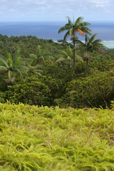
Nahnalaud — the Big Mountain
The Big Mountain
![]()
![]()
![]()
![]()
![]()
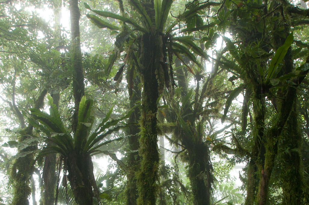
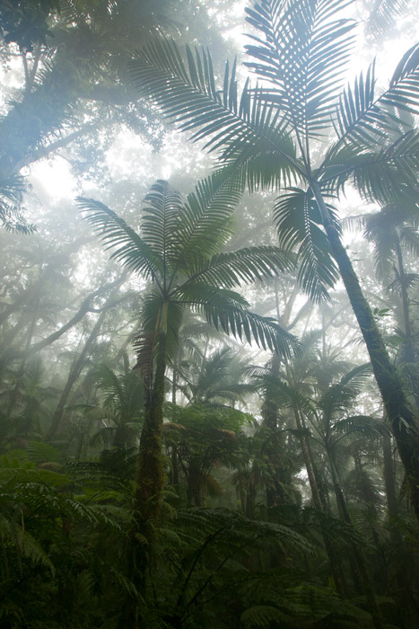
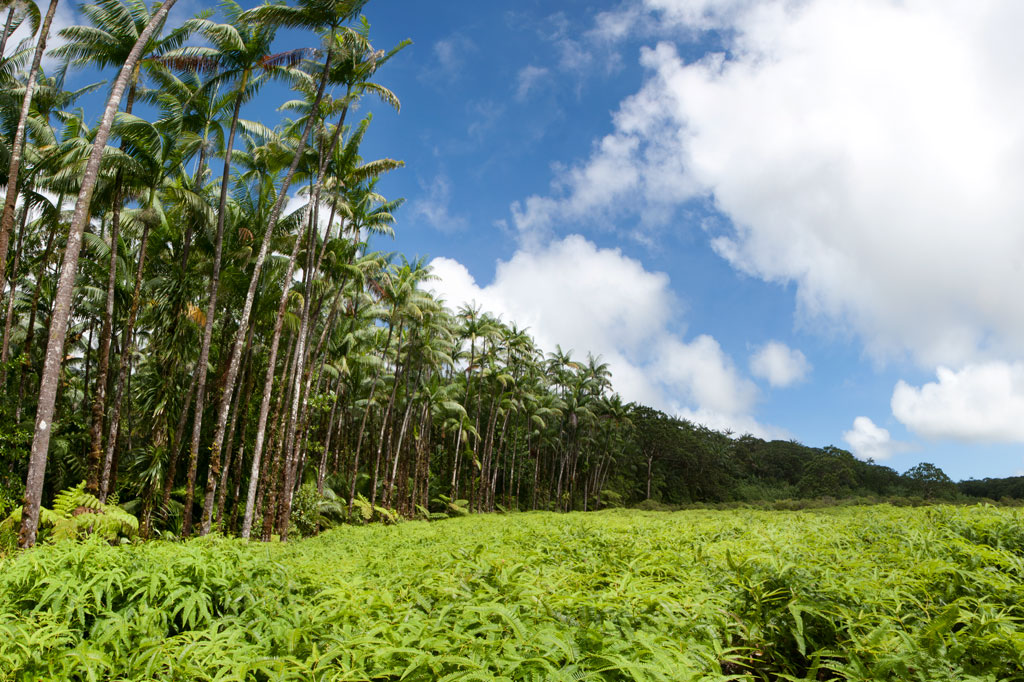
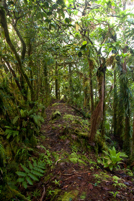
The highest mountain in the Federated States of Micronesia (FSM) is called Nahnalaud (which means “big mountain”) and is located almost in the exact middle of Pohnpei Island. Pohnpeians consider the mountain sacred and regard it with respect and reverence, though most people have never been there because of the long, difficult hike involved. Local deer hunters and upland sakau farmers are the most frequent visitors to the highland region. A limited number of foreigners also attempt the summit.
In reality, Nahnalaud is not a single mountain but rather the highest peak in Pohnpei’s contiguous central mountain system, which separates the five chiefdoms. The primary central ridge runs from west to east and then curves north toward U not far beyond Nahnalaud. Additionally, a secondary ridge runs south, leading to Pohnpei’s second highest peak, Ngihneni, and then turning sharply to the west. The two ridges fence in the long, narrow Nanmeir Valley — the most remote region on the island.
The exact elevation at the Nahnalaud summit is a matter of debate as the survey methods used in the 1970s to map the island have a significant margin of error. The official number is 772 meters (2,533 ft), but the peak may actually be higher than that — likely close to 780 m. Ngihneni (“spirit’s tooth”) is nearly the same elevation (a difference of a few meters), which has generated a long-running dispute about which is actually the highest point. Nett, Kitti, and Madolenihmw have also argued about which chiefdom can claim Nahnalaud, but according to the municipal boundary lines on the 1983 USGS map, each of these municipalities has a piece of the peak.
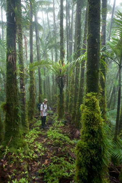
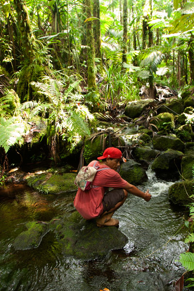
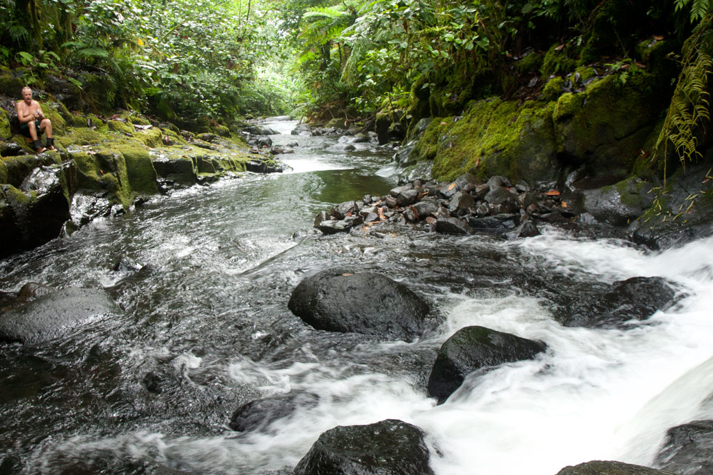
Hikers should be careful not to underestimate the mountain. Though the distance is not extreme, the terrain is. Experienced trekkers will find all of the approaches challenging merely because of the very rugged nature of Pohnpei’s interior mountains. The concept of switchbacks is little known on Pohnpei; trails are rough, rocky, and often go straight up the slope. Hikers who plan to tackle Nahnalaud should be prepared to walk along narrow ridges with steep slopes on either side; cross jumbles of broken, slippery rocks; ford medium-sized rivers (particularly on the Nett and Madolenihmw routes); walk in shallow, rocky riverbeds; ascend and descend slopes of 50 degrees or steeper; wade through muddy mires; cross slick logs; and push through high grass or ferns.
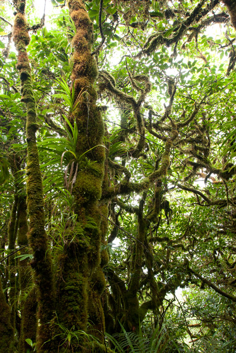
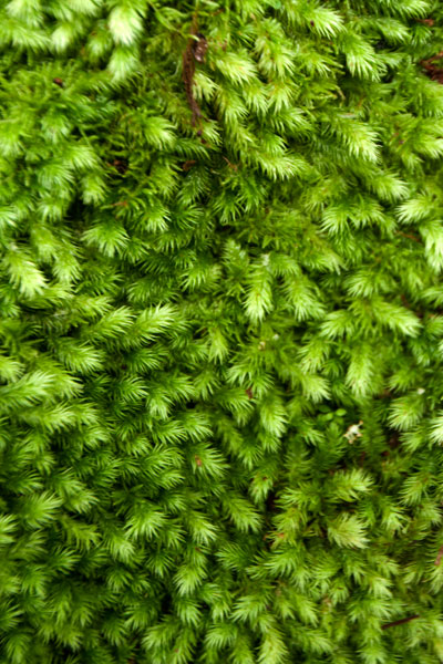
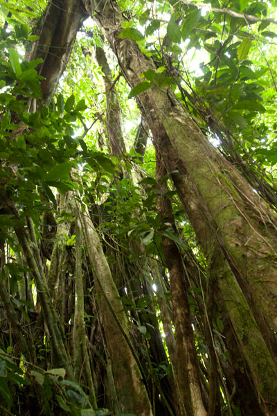
Despite the difficulty in getting to the top, the trip is well worth it. Those who have never visited a cloud forest before will be awed by the otherworldly beauty of the ridge, a perpetually dripping wonderland of stunted, hoary trees, air plants, and bryophytic growth. Virtually every surface is covered with a thick layer of spongy golden moss and the ground is composed of layer upon layer of damp, decayed matter. The area, which never dries out, gets at least 8.3 meters (325 in) of rain every year and is shrouded in thick fog much of the time, making clear views from the summit a rare occurrence.
[tabs]
[tab title=”Pehleng”]
Pehleng Approach (Western Kitti)
This well-defined trail up to the primary ridge and eventually to Nahnalaud was first promoted in 2013 by a local business calling itself Pohnpei Trailways. The idea was that this trail, starting in Pehleng, could be hiked by tourists without the assistance of a local guide. We strongly recommend that you do NOT do it that way. In fact, we think it’s a very a bad idea. Though at the time of writing (2014) the entire length of the trail was marked with pink flagging tied to tree branches, there is still plenty of potential for visitors to go astray. Furthermore, accidents or injuries without a local guide present could result in disaster. Remember that Pohnpei has no search and rescue service.
The true ascent begins after passing through a cluster of houses (ask permission) 0.95 km beyond the trailhead. After that, the trail is wide and true as it climbs steadily for 1.45 km (20% slope average) through the forest to the open fern meadow atop Dolen Salapwuk (510 m), where there are some good views in clear weather. The trail then re-enters the forest and begins to climb again for 4.6 km (13% slope average), narrowing as it comes up to the main ridge (696 m). Just before Shelter 1 (Dolmweir), there’s a 315 meter-long segment that is less than a meter wide with precipitous slopes on both sides; we’ve dubbed it the “Knife Edge.”
Shelter 1 is located at Dolmweir, where an appendage of the mountain thrusts north from the main ridge. There is no flowing water nearby. The privy is located 22 m to the north. After Shelter 1, the trail descends steeply by about 62 m on the south side of the ridge and skirts the base of a rocky cliff before climbing back to the ridge-top. From there it goes up and down for 2.94 km before reaching Mountain Shelter 2 roughly 5 minutes below the Nahnalaud summit.
- Plan for 5-7 hours from the trailhead to Shelter 1 and 3-4 hours from there to the summit.
[warning]NOTE: As of February 2014, the pandanus-thatch roofs of the two ridge shelters were in very bad shape, heavily deteriorated and leaky. Plan accordingly.[/warning]
The Origin of the Yap Banana
In the westward land of Sapani, a woman named Lienpwel (“woman of earth”) had two daughters, Lisoumokaiap and Lisoumokalang. The daughters decided to take a canoe and look for new land in the east and brought with them some “underworld yams”, banana shoots, and a stone called the Stone of Sahwar. The sisters eventually landed at a place in what is now Pwoaipwoai district (at that time the island was smaller and Pwoaipwoai lay near the coast). There they placed the stone and planted the yams. The stone was highly reflective, and when the sun would hit it, it would shine brightly (hence the name Sahwar, which means “shining” or “flashing”).
The younger of the two sisters, Lisoumokalang, eventually returned home to Sapani. On the way she visited the islands of Yap and propagated a new type of banana, which thrived and became the tallest of all banana varieties. Some time later, a Pohnpeian man who lived in a place called Loangen Kitti was looking west toward the sunset and he saw the tall banana plant in the distance. The ripe fruit were attracting many birds, so he found two starlings – one a common Micronesian starling (sioahk) and the other a Pohnpei mountain starling (sie) – and he took them up to a high mountain in Pehleng. The Micronesian starling was a lazy flier, but the mountain starling was clever and efficient. He sent both flying toward Yap. The Micronesian starling was distracted on the way and diverted from its course. Only the Pohnpei mountain starling reached its destination. It joined the other birds in eating the bananas, and while it did so, a seed became lodged in its feathers. Both birds eventually flew back to Pohnpei and landed at the peak of Pekenuht (which, appropriately, means “banana feces”). The seed carried by the mountain starling fell to the ground and propagated utin iap (the Yap banana).
[/tab]
[tab title=”Enipein Powe”]
Enipein Powe Approach (Kitti)
This route begins at the end of an unpaved road in Enipein Powe and climbs gradually on a well-defined footpath up an out-thrust from the southern ridge. At the top, the trail passes through a saddle between Nahnan Pwoaipwoai and Dolen Uhd, then descends slightly along the inside of the ridge slope, finally arriving at a massive overhanging rock known by local guides as “the cave.” The cave has nice views through the trees of the Nanmeir Valley at the Lehnmesi River source below. You can also see Nahnalaud to the northwest and make a guess at the direction of Ngihneni to the east. The cave is an excellent place to camp with a cushioned fern-lined floor (that stays dry in wet weather) and usually some dry firewood stowed by hunters in the vicinity (replace what you use).
From the cave, the trail continues along the inner slope below Ngihneni, crosses several small streams, and then climbs steeply (20% slope average) to the top of the main ridge. At this point it’s just a short walk west along the ridge path to the first open viewpoint near a USGS benchmark. The spot people typically consider to be the summit is 5-10 minutes further, and Shelter 2 is just below that.
- Plan for 6-8 hours from the trailhead to the cave and 90 minutes to 3 hours from there to the summit.
[/tab]
[tab title=”Salapwuk”]
Salapwuk Approach (Kitti)
There are many ways to Nahnalaud from Salapwuk but they all begin at the end of the road beyond Salapwuk Elementary School. The early part of the hike uses the same trail as the Six Waterfalls, but at the place where one would turn toward the river to encounter Falls #1 (Pahnairlap), one instead follows a trail going northeast. This trail stays north of the river, crossing above Iro, Nan Emp, and Lipwentiak waterfalls. The latter is the most spectacular, located where the river gets funneled into a narrow channel and makes a hairpin turn. According to legend, this feature of the river was created when the matriarch of the Great Eel Clan encountered an eel hunter and writhed violently in horror at the sight of the dead eels he was carrying. Small pools above the falls are home to Pohnpei’s endemic freshwater shrimp, which the guides might be willing to catch for dinner. After that, the trail only meets the river again twice, where it cuts through a wide loop in the watercourse. It then turns north and climbs 362 meters in elevation to the primary ridge, not far from the summit.
[/tab]
[tab title=”Nanipil”]
Nanipil Approach (Nett)
Though slightly shorter, the Nanipil approach to Nahnalaud is certainly challenging. It’s significantly steeper than the other routes (except Salapwuk) and the trail is not well-maintained once you reach the rear of the valley. The hike starts at the house next to the hydroelectric building at the end of Nanipil River Road. Immediately behind the house, hikers must cross a river and then shortly after that a small stream. An easy segment follows with a well-defined residential path leading to the last house in this part of the valley (1.39 km), where an old man lives alone.
Past the house, the route continues on a fairly well-defined path that crosses the river several times (these crossings can be tricky if there has been a lot of recent rain). In a few places, you have to walk in the river itself, which can be quite difficult given the slickness of the rocks. Finally, after 2.94 km (3% slope average), the trail begins to climb out of the valley on the east side of the river and follows a sub-ridge up from there (3.16 km with a 22% slope average).
The climb has several pitches with small, flat rest areas in between. The first stop has a conspicuous tree of gigantic proportions entwined with vines almost as massive. The second stop is frequently used as a camp site by hunters and is one of the few places on the mountain with mobile phone reception. The final segment leading to the primary ridge is steep and often muddy. In places it follows the natural pathway of small streamlets (keep an eye out for a small waterfall high up on the slope). Once reaching the main ridge (754 m elevation), it’s an easy 0.56 km walk east to Shelter 2, a typical nahs-style thatched hut that can sleep ten or so.
[warning]NOTE: As of February 2014, a large part of the roof of this shelter had rotted away, leaving the central part of the hut exposed to the elements.[/warning]
[/tab]
[tab title=”Nankepinmerepw”]
Nankepinmerepw Approach (Madolenihmw)
This route passes through the gorgeous valley of Nankepinmerepw, following the upper tributaries of the Nan Riohk Stream and eventually arriving north of Nahnalaud on an arm of the primary mountain system.
The hike begins at a rutted turn-off from the well-graded (but unpaved) road to Pahn Sile Waterfall, leads to a metal footbridge over the Senipehn River — the only bridge like it on the island — and connects with a path on the far side. From there, the trail meanders northwest not far from the Nan Riohk and more or less parallel to it.
The first kilometer or so cuts through cultivated lands. Then it begins to follow the water more closely as it passes into the wilder riverine forests. There are at least nine major stream crossings in this next segment, some of which may be difficult or impossible if there has been a lot of recent rain. Above the last major Nan Riohk tributary, where the name of the stream changes to Nankepinmerepw, hikers take to the stream bed itself, which is certainly the most challenging aspect of the route (13% slope average). The algae-slimed rocks are slick and dangerous and hikers may find that they have to go very slow and use both hands to avoid disastrous slips; it would be easy to snap an ankle or shatter a kneecap in this place. Despite the rough terrain, the scenery in this narrow valley, often fenced on both sides by high rocky walls, is terrific. At times, the trail passes along the tops of vertical prismatic basalt columns.
The first few points of interest are beautiful pools that will tempt any overheated hiker — and why resist? A bit further is a small waterfall near a prismatic basalt quarry site for Nan Madol. Abandoned prisms can be found lying in the stream bed in several places — the largest just below the falls. How exactly prisms were hauled down to the coast from this site is anyone’s guess. After a short, steep section (22% slope average), the valley terminates at a huge “horsetail” waterfall that the route crosses above (you can scramble down the eastern slope without too much difficulty for a better view from the side). The shallow pools above the falls are also an excellent place for a look at Pohnpei’s native crayfish.
Past the big waterfall, the stream narrows until it reaches a third waterfall — this one short and wide, falling over a straight lip (usually called a “block falls” or “sheet falls”) — and then diminishes to a trickle. From this point, the hike climbs west (29% slope average) and then south again as it follows the ridgeline (18% slope average) toward the Nahnalaud summit.
[/tab]
[/tabs]
How Long Will It Take?
Though it is possible to hike up and down Nahnalaud in one day, as we did during one of the many data-gathering excursions, we don’t recommend that you put yourself through that kind of torture. Hiking to Nahnalaud should be considered a 2-day affair with one night spent either at the cave, one of the mountain shelters, or somewhere else on the ridge. Inexperienced or out-of-shape hikers may need three days or more.
Hiring a Local Guide
All of the routes up to Nahnalaud require an experienced local guide.
You should offer your guide no less than $160 if there are five or less in your group and at least $220 if there are more than five (plus tips). If you do the math, you’ll see that this is quite reasonable. With five people, each hiker pays just $32 plus tips — a super bargain. If you can’t assemble a group, you’ll still only pay $80 per person with two hikers, which is less than you’d pay for two dives at virtually any SCUBA company in the world (and this is two days and one night). Obviously, if you plan to take a slower pace and do the hike over three or more days, you’ll need to pay your guide more.
Your guide is your lifeline; you will depend on him to keep you safe and on the right track throughout the duration of your hike. Guides provide other useful services as well, such as making campfires in damp weather. If you expect your guide to cook meals for the group or carry any gear for you, he should be paid extra. Agree on a price beforehand.
- Please visit the Local Guides & Tour Operators page for a list of experienced guides available for hikes to Nahnalaud.
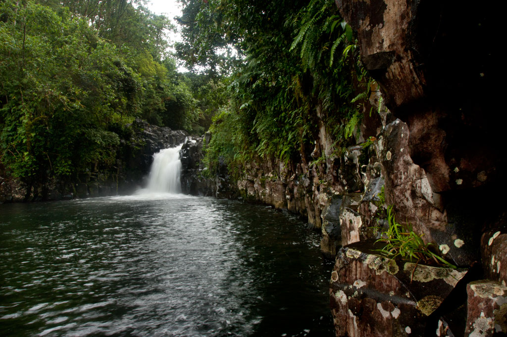
Sahwartik & Sahwarlap Waterfalls
![]()
![]()
![]()
![]()
![]()
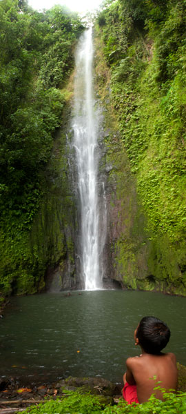
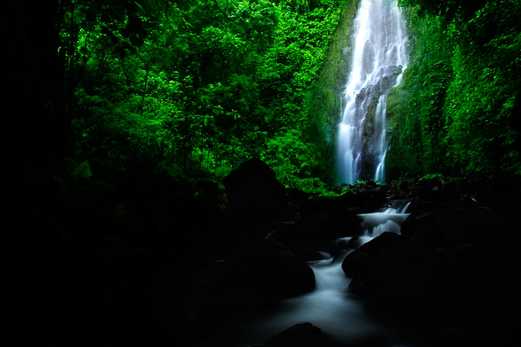
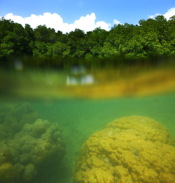
Located on converging streams within Salapwuk’s deep Sahwar Gorge, Sahwartik and Sahwarlap are a pair of waterfalls whose splendor and grace defy reality. The wider falls is named Sahwarlap, which means “shining brightly,” and its tall, thin neighbor is called Sahwartik (“shining faintly”). Sahwartik, a “horsetail” falls, is the more picturesque of the pair and is probably the tallest waterfall on Pohnpei at about 20-24 meters (65-80 ft). It lies at the terminus of the gorge, hidden in a fern-carpeted niche with a sizable plunge pool and enough flow to create its own misty breeze. The water is very clean and often quite chilly — amazingly refreshing after a hot hike. Sahwarlap’s stream angles into Sahwartik’s from the northwest. The falls is wider and shorter than Sahwartik and has a much shallower pool. Both waterfalls are great for a mid-hike swim, but Sahwarlap‘s pool is shallow, while Sahwartik‘s is relatively deep.
The trek begins east of the road that leads to Salapwuk Elementary School, just before the paving ends (park under the trees on the east side of the road). After crossing the landowner’s property, a well-maintained trail begins at the rim of the gorge with inspiring views of both waterfalls, then descends in a zigzag along the slope to the stream bed. The slope trail is generally well-tended, but without any railing on the outer edge. Hikers should move slowly and with care. In a few places there are rough steps that can deteriorate after heavy rain.
Once one reaches the bottom of the gorge, there’s no obvious trail, but the way is clear. Merely head up-stream and stick close to the water — a collection of little streamlets. There are no deviations from the valley, so it’s impossible to lose your way before hitting Sahwartik. Sahwarlap can be a little trickier to locate. Hug the west side of the stream bed and keep your eyes peeled for a path near where the Sahwarlap Stream (Pilen Sahwarlap) flows into the larger watercourse (Pilen Sahwar). This footpath climbs over a little hillock, from the top of which the falls is visible through the trees.
Note that sakau (known elsewhere as kava) is heavily cultivated throughout the west side of the valley and along the slope trail. The large shrub with its heart-shaped leaves and thick, knobby branches — sometimes pure green, but more often mottled — is easy to identify. The plants have great value to their owners. Hikers should treat them with respect and avoid breaking branches or otherwise damaging them as they pass.
The Sesiwo family charges $5.00 per person for access. No guide is necessary for this hike, but if you want one, the family can scare up some kids to go with you. Offer $5.00 and make sure that everyone is clear that you’re paying one person, even if a whole group of kids trail along behind.
- Plan for 90 minutes to 3 hours round-trip with a swimming session at each waterfall.
How the Sahwar Valley was Formed
There was once a woman in Salapwuk named Lienlama who had two sons named Mwohnmur and Sarapwau. The boys had many adventures and became notorious in Pohnpeian legend, being responsible for the creation of a number of interesting geographical features including Takaiuh (hill), Pohnpaip (rock), and the island of Takaieu. The boys were eternally curious, and one time they took their mother’s loom stick (made from a sword fern) and dug in the earth to see what was below it. The hole that they dug was so deep that they reached the Underworld, and because they could see the shining lights of that other world through the hole, the gorge was named Sahwar, which means “shining” or “flashing.”
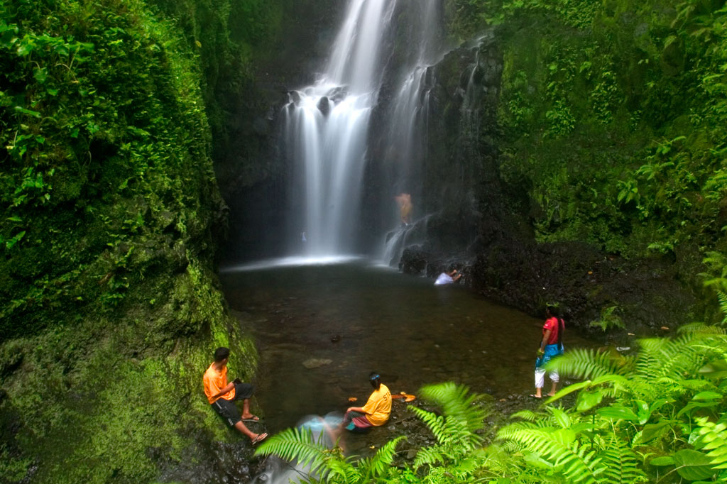
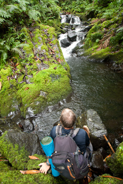
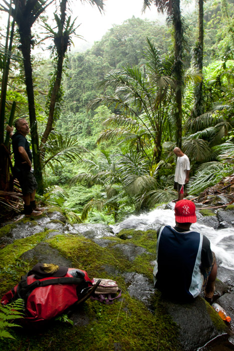
The Six Waterfalls Hike
![]()
![]()
![]()
![]()
![]()
")
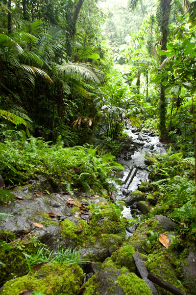
Because Pohnpei’s rainforested terrain is so challenging to move through, inexperienced hikers might think a jaunt into the wild interior of the island is out of reach. It isn’t. Almost anyone in relatively good physical condition can handle the “Six Waterfalls Hike”, which delves into the verdant forests and lush raparian environment of the remote Nanmeir Valley above Salapwuk.
The adventure begins near Salapwuk Elementary School. The early part of the hike follows a wide, mostly flat track through the trees. This is a good place to look for Asian waterbuffalo, or carabao, which some of the Salapwuk residents use as beasts of burden. The large, big-horned animals, which were brought to Pohnpei from the Philippines by the Spanish in the 1890s, may look fearsome, but are actually quite shy, gentle creatures. You might see one lolling about in a patch of mud or plodding along with a smiling child perched on its back.
")
Over time the track becomes a narrow footpath and begins to roll up and down as it passes through hilly native forests. Shortly after crossing the Sihngar Stream (Pilen Sihngar), there’s a fork in the trail. Continuing straight will keep you above and west of the river, while the eastern way leads down toward the upper Lehnmesi River and Pahnairlap, a serene punchbowl falls with a great little pool beneath it.
The rest of the hike follows along the banks of the river and occasionally crosses over it, stopping at four more waterfalls — Nikotoapw, Olotong, Iro, and Nan Emp — each with its own unique character. This segment is quite difficult, as hikers must traverse the round, jumbled stones that line the riverbed and its banks. Go slow, use your hands, and watch your footing.
Nikotoapw Waterfall is found a bit to the east of the river, above where the Nikotoapw Stream (Pilen Nikotoapw) joins the Lehnmesi. The site is screened by a pool with a wide “block falls” behind it, which hikers must circumvent. On the other side, the stream issues from a narrow slot. Continue through this and one comes to an enclosure mostly hidden from outside. There lies the falls and its sizable pool. If you swim under the falls and climb up on the rocks behind, you’ll find a cave.
")
The third falls, Olotong, is found on the opposite side of the Lehnmesi from Nikotoapwpw. This is followed by plenty of hiking in the riverbed and one segment where the trail leaves the river and cuts through the forest before coming back to the watercourse. Iro and Nan Emp are both found on the west side of the river not too far apart.
The sixth falls, called Lipwentiak, is also hidden from view by the topography. At one point the river narrows and passes through a high-walled slot. Though there is a way up and around, the easiest and safest way past is to swim through the slot. On the other side, the walls open up to reveal a large pool with high walls on all sides, an island of cobbles, and beyond all that, a tiered “horsetail falls” that flows from a vaguely heart-shaped portal of dark rock. It’s very dramatic.
In all, the trek offers tons of great swimming and truly unreal scenery. Good footwear is a must.
- Plan for 6-8 hours round-trip with short swim breaks at each waterfall.
- Please visit the Local Guides & Tour Operators page for a list of experienced guides available for the Six Waterfalls Hike.
The Story of the Eel of Pahdol
A long time ago, a couple from Wene came to live in a place called Iro. One day there was a great storm and the heavy rains resulted in a huge flood. Two women in the area went out to fish in the flood, and while they were fishing, a starling flew over and dropped a small stone. The women took the stone home and gave it to the couple from Wene. Later, at a place called Pahnkipar (“under the pandanus tree”), the stone broke apart and from it was hatched a tiny freshwater eel. The couple kept the eel as their pet and allowed it to live in a pool at Pahdol (“under the hill”) in Pahnais. When the eel grew up, however, it began to act in sinister ways. At night, the eel would escape from its pool and sneak into the house, where it would stare at the sleeping couple. The couple became uncomfortable and decided to kill and eat the eel, but the eel overheard their plan, came into the house, and attacked them. The couple fled into the forest and hid under a huge rock, where they believed they’d be safe. The eel discovered the hiding place and ambushed the couple, devouring them alive.
The eel then traveled into the Nanmeir Valley in Pohnpei’s interior and followed the Lehnmesi River source. There she met Kiroun Meir, a high-titled man, who brought her to live with him at his home. The two became lovers and the eel was impregnated. She was restless, however, and departed, continuing to follow the river. At Lipwentiak, the eel encountered a hunter named Kiroun Mand, killing and eating eels. Recoiling at this sight, she created a sharp turn in the river with the writhing of her body. Soon after, she gave birth to her first daughter, the matriarch of the Sounlipwentiak subclan. She had other children later who became the founders of the Lasiadohng (“eels of the dohng tree”) and Lasiakotop (“eels of the kotop palm”) subclans. After that, the eel went to live in Dauen Sapwalap, where she terrorized the local inhabitants, devouring so many that the land became mostly deserted. When the monster finally died, her body formed Dolen Nett.
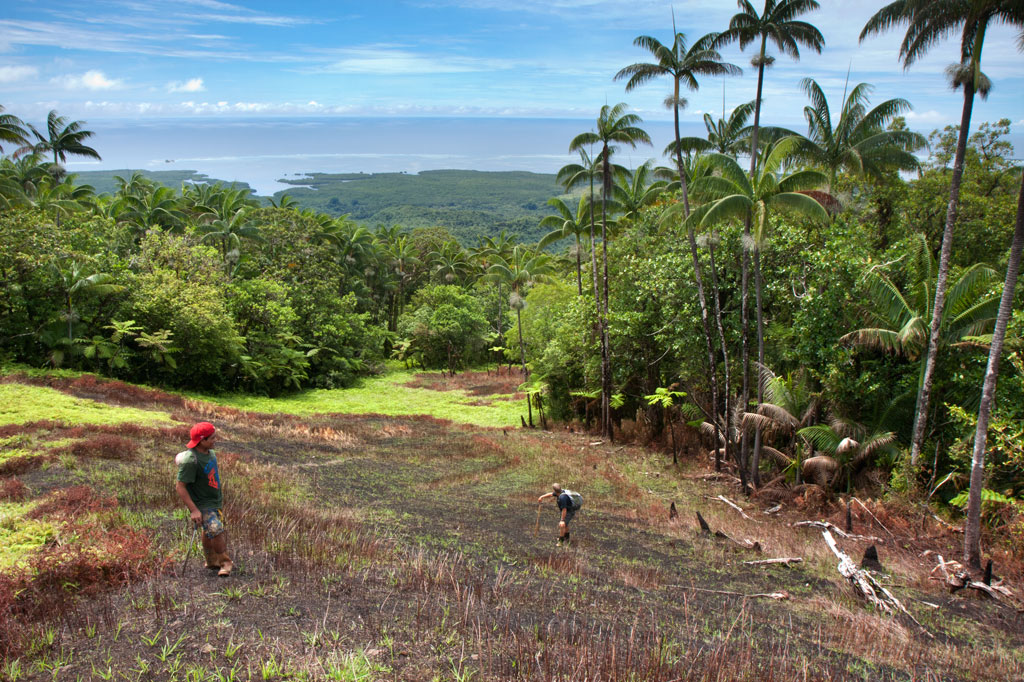
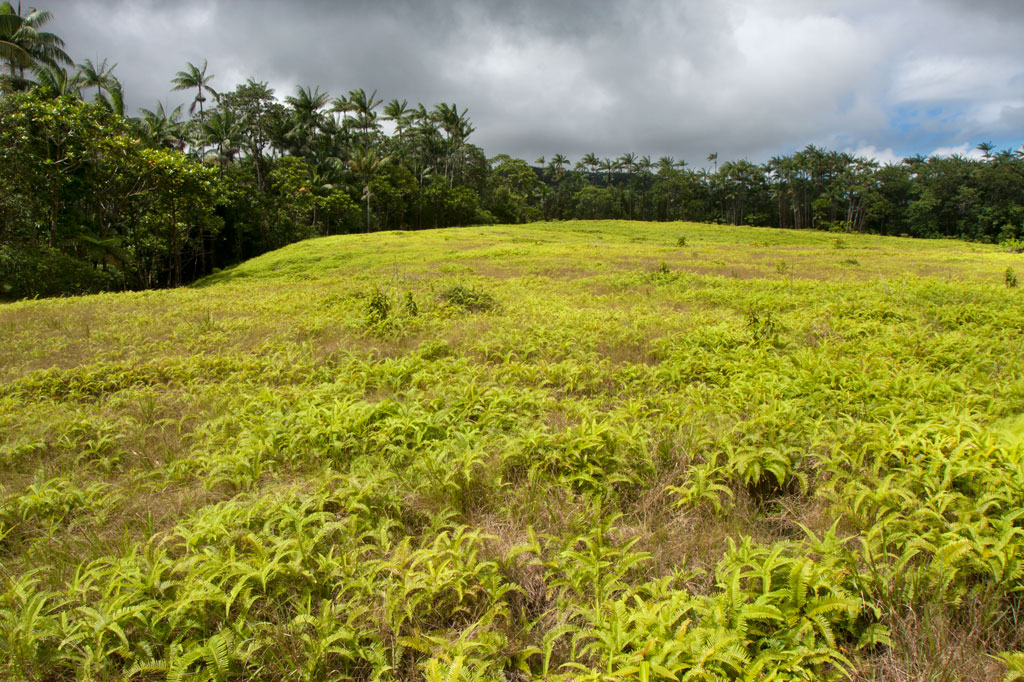
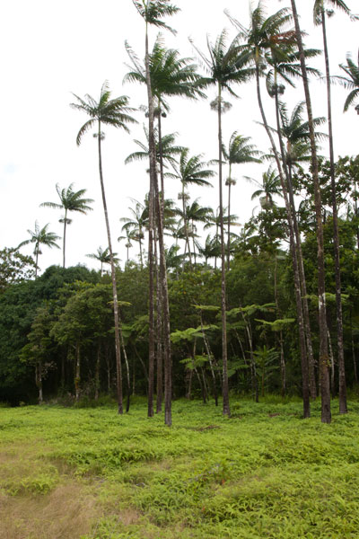
Pohn Pehnmen Savannah
Mallen Pohn Pehnmen
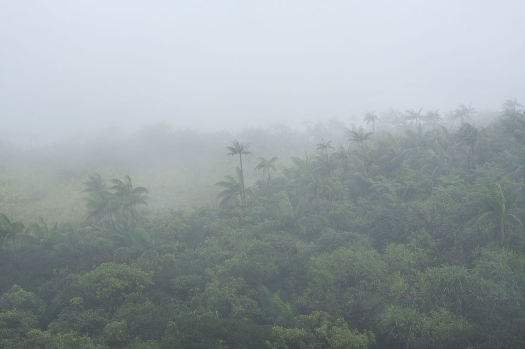
In the remote mountainous area called Pohn Pehnmen is an upland savannah similar to those on the Nihpit plateau, but smaller and at a much higher elevation. The meadow, reached by deviating west from the Enipein Powe trail to Nahnalaud, has a strong slope to it with a central hill and an open view of the ocean and lowlands. Most of the area is covered by low, spreading ferns and club moss, while giant tree ferns and endemic kotop palms (Clinostigma ponapensis) are clustered along the fringe.
Like Nihpit, the moderately difficult, but rarely steep, trail is dominated by groves of Atuna racemosa, which Pohnpeians call ais. This tree’s unusually hard wood, termite-resistant quality, and straightness makes it a popular choice for construction projects on the island. The fruit are also used medicinally and to create the red paint commonly used on Pohnpei canoe hulls. You’ll see bio-luminescent salengen eni (“ghost’s ear”) mushrooms, many types of bracket fungi, including one that has sadly been the target of poaching by visitors from at least one Asian nation, and a startling diversity of bryophitic growths on trees and logs. There are a number of small stream crossings. Birders will find a lot to look at both in the forests on the way up and around the meadow.
The hike begins at the end of the road near the FSM Telecom mobile phone tower, cuts through a grassy clearing, and enters the first. The 0.26 km (0.16 mi) to the first branch in the path is mostly flat; bear right. After that it climbs pretty steadily for 1.4 km (0.87 mi) at about a 17-18% slope. There’s another branch about 0.52 km (0.32 mi) from the top; again, bear right.
- Plan for 5-8 hours for this hike.
- Please visit the Local Guides & Tour Operators page for a list of experienced guides available for hikes to Mallen Pohn Pehnmen. Offer $25-50.00 for a group of five or less.
Lehnpaipohn Waterfall
Kitti has a lot of waterfalls, but one of the most fun to visit is Lehnpaipohn between Salapwuk and Pwoaipwoai districts (at least two kousapw claim the falls area). It is neither the tallest waterfall on Pohnpei nor the most picturesque, but what Lehnpaipohn does have is the largest freshwater pool on the island (about 80 by 30 meters) and the highest jumping-off spot. The pool is leaf-shaped, very deep, and surrounded by high cliffs with a sizable island of river cobbles in the center. The water is typically quite chilly, which is a good thing after the hike. The waterfall itself is not much more than 4 meters (13 ft) tall and has a platform of rock behind it that you can stand on. Swimming to it is difficult, however, because of the strong current coming away from the falls. The best tactic is to swim along the edge and use the rocks to pull yourself forward.
The trail is only 0.53 km (0.33 mi) from the unpaved secondary road, but that road’s conditions are so bad that you’ll want to park your vehicle way down at the end of the paving 0.4 km (0.25 mi) above the Circle Island Road and walk up (5-15% slope with an average of about 7%). Look for the unmarked footpath on the left 2.18 km (1.4 mi) beyond the paving and 117 meters (128 yd) past the last visible residence on the right. The path is well-defined, relatively easy to follow, and downhill almost the whole way to the river (12% slope average). It stays under the trees and is rocky except at one point, where there’s a swampy section to cross or navigate around. About 216 meters (236 yd) along, the path branches; stay to the left. Another 200 m (219 yd) brings hikers to a small stream crossing. From this point, there’s only another 89 m (97 yd) to go. The final descent to the pool is exposed and a bit sketchy (especially when descending); make sure you have good footwear (FiveFingers are best, but good tennis shoes will work, too) and take special care on wet days.
No fees are charged and the trail is on public land. You can do this hike without a guide.
Camping
You can camp under the trees at the top of the eastern cliff — also the spot from which swimmers leap. Pack out everything you brought in and leave the site as you found it.
- Plan for 3-4 hours for this hike including some quality time to swim and relax.
Nihpit Plateau Savannahs
Mallen Nihpit & Mallen Pitetik
On the large upland plateau of Nihpit in the mountains above Mwoakot are two expansive savannahs or fern meadows. Upland savannahs of this sort usually exist because the bedrock is shallow, but they are also periodically burned by residents, inhibiting the growth of larger shrubs and trees. Hunters say that the Philippine sambar deer that live in Pohnpei’s interior — probably introduced by the Germans from the Mariana Islands — are attracted to the ash. One hunting tactic is to lie hidden at such sites and wait for the deer to creep from the forest in the early dawn (photographers might use the same method). Both of the savannahs soak up rain and feed tributaries of the Ne Stream (Pilen Ne). The northernmost and the larger of the two meadows — about a half kilometer in length — is usually referred to as Mallen Nihpit. The other savannah is Mallen Pitetik. Birders and photographers will find this a wonderful place to camp and observe fauna rarely disturbed by human activity. The palm forests around the edge provide plenty of shade, and drinking water can be filtered at the stream about 100 meters away.
The hike begins on the right side of the unpaved secondary road opposite the track leading to the Wene Latter-Day Saints Church — 0.92 km (0.57 mi) past the Nanwou Stream bridge — and leads up to a farmstead. Your guide will stop at a cluster of residential buildings to ask permission to cross the family’s land before leading you on. About 160 m beyond this is the first of two major stream crossings — one on a log and the other across a covered wooden bridge. After the second bridge, the trail climbs steadily for 1.47 km (0.9 mi) at a 25% slope average into forests full of huge Terminalia carolinensis (kehma) — found only on Pohnpei and Kosrae — and Atuna racemosa, a tall, straight hardwood locally called ais. The latter have many uses including treatment of diarrhea and dysentery. The white nut inside the ais fruit is ground and mixed with red soil to produce paint for canoes, while the extremely hard and termite-resistant lumber is a favored building material. If you hike in the evening, keep an eye out for eerie salengen eni (Filoboletus manipularis), bioluminescent mushrooms said to grow in areas where ghosts reside (the name means “ghost’s ear”). The tiny fungus often grows from rotten logs and looks like clusters of eyes in the dark. Interestingly, some Pohnpeian parents are known to control misbehaving youngers by threatening to send them to places where the mushrooms thrive. At this point, hikers have reached the edge of the plateau and the remaining 1.08 km (0.67 mi) is relatively flat with a 6% slope average. There are four small stream crossings along the hike. The first three come down from Mallen Pitetik and converge, forming a high waterfall as they drop off the plateau; follow the second stream up for 0.34 km (0.2 mi) to reach that savannah. The last stream originates in Mallen Nihpit and makes a good place to filter/purify water when camping in the area.
- Plan for 8 hours for this hike.
- Please visit the Local Guides & Tour Operators page for a list of experienced guides available for hikes to Nihpit. Offer $50.00 for a group of five or less.
Wou Kutoahr
![]()
![]()
![]()
Today, the name Wou Kutoahr is used to refer to a large area of upland fern meadows, palm forests, giant tree fern stands, and denser hardwood forests, though it actually means “kingfisher valley” and originally referenced a specific feature nearby. There’s a little bit of everything here for hikers and birders. Most of the birding is to be had in the forests below the Nan Peienlam meadow. All of the common species can be seen, as well as rarer birds like the Micronesian pigeon, ground dove, crimson-crowned fruit dove, and long-billed white-eye. There are also some interesting species of plants to be found in the same spots, including native mace (Myristica fragrans), which produces walnut-sized seeds covered by a rubbery bright-red skin. These trees were introduced from Sulawesi by the Japanese in the 1920s. Pohnpei’s endemic palm, called kotop, is common around the fringes of the meadows and on some of the nearby slopes.
You can begin your hike wherever necessary along the unpaved road leading up from the FSM-Chinese Pilot Farm near the Circle Island Road, though most vehicles will need to park further down due to the extremely poor condition of the track. Wherever you start, follow the road up until it narrows to a footpath. This path climbs gradually with an 9-10% slope and to the first savannah. If you walk out among the ferns to the south, you can get some decent views on a clear day. The path continues to climb at the same rate from there, passing into a section of forest dominated by giant tree ferns and beautiful hardwoods. This the key place for birders. In the middle of the forest segment, the trail levels off to about a 4% slope, eventually leaves the forest, and arrives at the second set of fern meadows. A knoll to the south offers excellent views of the lower forests and ocean. Other trails continue 0.74 km from Nan Peienlam to Dolekole (363 m) and 0.67 km to the Mese Stream (Pilen Mese) from the middle of the forested section.
Camping
The kotop (Clinostigma ponapensis) stand on the edge of the upper meadow is a wonderful place to camp with amazing scenery all around and some protection from wind. The nearest fresh water is at Pilen Mese (purify or filter it) about 1.2 km north. Leave the area exactly as you found it and pack out everything you brought in.
No fees are charged for this hike. You can do this hike without a guide.
- Plan for 4 hours round-trip for this hike.
Nan Madol Ruins
[tabs]
[tab title=”Nan Madol”]
Nan Madol Ruins
![]()
![]()
![]()
![]()
![]()
![]()
![]()
![]()
![]()
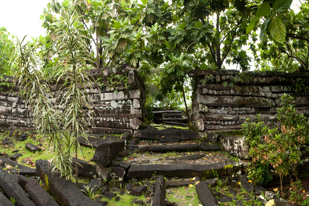
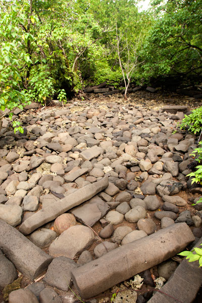
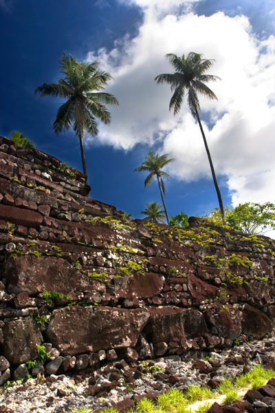
Nan Madol is a prehistoric “city” of more than ninety man-made islets off the coast of Temwen Island, constructed of naturally-occurring prismatic basalt columns, basalt boulders, and coral fill. Many of the islets have large, complicated structures on them composed of the same types of rock — stones as heavy as 90 tons. Together, the islets formed a powerful administrative and religious complex from which the island of Pohnpei was ruled for several hundred years by a line of tyrannical monarchs called Saudeleurs. The lower city, Madol Pah, was the administrative center, while the upper city, Madol Powe, was the ceremonial heart of the complex.
Megalithic sites like Nan Madol are rare around the world and even rarer in the Pacific. Anyone who has seen the city would place it alongside other more famous megalithic feats such as the pyramids of Egypt and Central America, Stonehenge, Machu Picchu, and Rapa Nui’s moai. And yet, Nan Madol is little-known outside the archaeological community and visited by a surprisingly small number of people each year. Nan Madol was inscribed onto the UNESCO World Heritage List in July 2016.
Archaeological Work at Nan Madol
Archaeological investigation of the ruins began during the German Period in the late 1800s. German anthropologist Paul Hambruch created the first map of Nan Madol in 1910, which is often still used today. During the Japanese Period (1914-1945), three different archaeologists — Hasebe, Yawata, and Muranushi — conducted surveys and excavations. Sporadic field research has been on-going ever since with Japanese and American archaeologists (Saxe, Allenson, Loughridge, Ayres, Haun, Bath, Athens, Mauricio, Kataoka, and Nagaoka) doing the bulk of the work. Masao Hadley, Rufino Mauricio, and Pensile Lawrence were instrumental in piecing together the oral history relating to the site. Little of the archaeological findings, however, have made their way to the general public, and there is a great deal of unpublished material that has never been released in any form — to the great detriment of the historical preservation effort.
About 30 of the islets have been meticulously surveyed and mapped to date. Even so, there remains much to be learned about the ruins. Those reluctant to accept the mythical explanation of the city’s origin have theorized wildly about how such an engineering feat could be achieved. The basalt columns at Nan Douwas are as heavy as 5 tons and are stacked log cabin-style to form walls has high as 7.5 meters (25 ft), while boulders weighing as much as 90 tons are piled to heights of 8 meters (26 ft) at Pahnwi. Though it is plausible that stones might have been hoisted into place with the help of ropes, levers, earth ramps, and mass man-power, the real question that has bothered everyone (except Pohnpeians) is how the stones got to Temwen Island at all. Most of the quarry sites are nowhere near Nan Madol; in some cases they are on the other side of Pohnpei. How did the builders transport the columns over such distances? The foremost theory proposes that the stones were floated on rafts through the lagoon, but as the process has not been successfully demonstrated, the mechanics of Nan Madol’s construction will likely puzzle scholars and amateurs alike for years to come.
Kahnimweiso — the Sunken City
The eerie blue deeps between Madol Powe (the upper city) and Nahkapw Island are known as Pahn Nahkapw — “below Nahkapw” — and are believed by some to be the resting place of an ancient city called Kahnimweiso. In the late 1970s, archaeologist Arthur Saxe was told of the city Olsihpa and Olsohpa saw from a mountaintop prior to building Nan Madol and was intrigued. If Kahnimweiso had existed at all, Saxe wanted to know how it could possibly end up on the bottom of a reef passage.
Saxe noted that some aspects of Pahn Nakapw were unusual. At first glance it appears to be a pass, and yet it has no outlet; in the north, the deep water terminates just beyond Na Island. Saxe postulated that Pahn Nahkapw could be a “blue hole” — a collapsed section of fringing reef — rather than a true channel. According to his theory, freshwater run-off from Temwen seeped down beneath the reef and dissolved sections of it over a long period of time, forming passages and caverns. The weight of the basalt used to build Kahnimweiso eventually caused a cataclysmic collapse of the reef shelf and sent the city to the depths.
Diving due east of Kerian, Saxe discovered a line of “pillars” on the seafloor, which he thought might be part of the fabled gate to Kahnimweiso. Disappointingly, the pillars were later proven to be natural coral formations rather than basalt columns. No serious underwater exploration has been done since, and yet the mystery continues to fascinate. A Japanese archaeologist took bathyspheric measurements at Pahn Nahkapw in 2012 and determined that the deepest area is about 65 meters (213 ft). Do the remains of a city really lie under the water? Additional research is needed to answer the question definitively.
[/tab]
[tab title=”History”]
A History of Nan Madol

The story of Nan Madol began around 900 A.D. with the arrival of two mysterious brothers named Olsihpa and Olsohpa. Oral history states that this pair came from Katau Peidi, an unknown island in the West (who some claim is Yap). Whether they were sorcerers or holy men is a matter of debate, but there was something extraordinary about these men. Until that time, Pohnpei had never had a unified political structure, but that was exactly what Olsihpa and Olsohpa wished to create. They landed first at Soupaip (an ancient name for Sokehs Island), built some stone structures in Ipwal, and then departed because the local inhabitants seemed hostile to outsiders. Next they stopped at a point on the coast of Tipwendongalap (in what is now Nett), but the currents and waves there were too strong for building. The third stop was on the northern coast of Takaieu Island in Wenik Peidak (now U) and the fourth at Likin en Mwahn near present-day Alohkapw, Madolenihmw. But neither of these locations was acceptable. Climbing a nearby mountain (Pohn Tehnmei), the brothers looked down for the first time on the panorama of Sounahleng — the “reef of heaven” — in the area around Temwen Island. They saw something there, but it’s not clear what; either a vision of what was to come or the actual ruins of a city originating even further back in Pohnpei’s ancient past (some of the less elaborate stone structures at Nan Madol may have been built as early as 500 A.D.). Whatever the case, Sounahleng was perfect.
Using their supernatural abilities, the brothers flew huge boulders and prismatic basalt columns from all over Pohnpei and assembled them into a 1 km2 (200-acre) capital city with more than ninety artificial islets connected by shallow canals. They named the region Deleur and the city Nan Madol after the spaces between the islets. After Olsihpa’s death, Olsohpa declared himself Saudeleur, “Lord of Deleur”, supreme ruler of all Pohnpei. He was the first ruler in a dynasty that lasted perhaps as long as 500 years.
Under the Saudeleurs, Pohnpei was divided into three parts. Malenkopwale consisted of what is now Madolenihmw and U, Pwapwalik was made up of the areas now called Sokehs and Nett, while Kohpwaleng roughly coincides with modern Kitti. Olsohpa and the Saudeleurs that followed him were completely supported by forced tribute from the Pohnpeian people with tribute events following the harvest seasons of important island staples, such as breadfruit and yams. The Saudeleurs brought the people under their control by giving titles to the leaders of the various semi-autonomous regions around Pohnpei. Each title came with specific obligations toward Nan Madol. The Saudeleurs also attempted to impose their religion — centered around the worship of the god Nahnisohnsapw — on the populace. Every year, a special ceremony of atonement was held at Idehd islet, where a turtle was sacrificed to a sacred eel. If the eel accepted the offering, Nahnisohnsapw was pleased with the people.
As time progressed, the Lords of Deleur became more and more tyrannical. One of them required tribute for every single thing a person possessed, including the lice on his or her body. Another Saudeleur had a hankering for human flesh and made sure the fattest Pohnpeians ended up as his dinner. A fearsome dog, Ounmatakai, kept an eye on the people and reported anyone who broke laws or failed to fulfill his or her duties. Violators were brutally punished at the Saudeleur‘s residence, Pahn Kadira, and sometimes executed afterward at an islet across the canal that came to be known by the ominous moniker Wasao — “that place.”
Unrest began to spread. The boldest regions of the island, including Palikir and Kepihleng (areas in what are now Sokehs and Kitti), began to defy the authority of Nan Madol. When the Saudeleur tried to bolster the influence of the Nahnisohnsapw religion, the region of Salapwuk (which had its own religious cult devoted to Nahnsapwe — the thunder god), rebelled. This event was the beginning of the end for the Saudeleurs. Threatened by Salapwuk‘s defiance and competing religion, the Saudeleur imprisoned their god, Nahnsapwe, at Pahn Kadira. Nahnsapwe, however, escaped and fled to an island in the East, which some say was Kosrae. There he impregnated a mortal woman, who bore a son named Isokelekel.
As Isokelekel grew up, he learned the story of the Saudeleur and vowed to avenge his father. When he became a man, he trained 333 warriors and set sail for Pohnpei. He landed first at And Atoll, 15 km southwest of Pohnpei, and dwelt there for some time, learning about the island from the atoll’s residents and acquiring a wife. He then took his canoes, passed through Kehpara Pass (Dauen Kehpara), and sailed clockwise around the island toward Nan Madol. The Saudeleur was initially suspicious of the newcomers, but as they showed no obvious signs of aggression, he invited them to stay at the islet of Kelepwel. They lived there for some time, marrying Pohnpeian women and fathering children. Eventually, however, some small disagreement blossomed into open war. After several days of bitter fighting, the Saudeleur‘s men gained the upper hand and it seemed as though Isokelekel would be defeated. At that moment, one of his fiercest warriors, Nahnesen, rallied the fighters, spearing his own foot to the ground to show that retreat was not an option. The tide turned, and Isokelekel’s men chased the Saudeleur‘s army all the way to Sapwalap. The final battle was fought at a waterfall called Kamau Pwoungapwoung. There the last Saudeleur was utterly defeated and transformed into a small blue fish that resides in that pool to this day.
After the battle, Isokelekel was given the title Nahnmwarki and became the first paramount chief. His domain — the eastern part of Pohnpei — was renamed Madolenihmw, which means “separation between the houses.” Isokelekel and his descendants continued to live at Nan Madol until the early 1800s when the city was finally abandoned and left to the wind, the water, and the trees. No one is certain why the Nahnmwarki deserted Nan Madol, but a likely possibility was that living on the artificial coral islets, where little could be grown or produced, just wasn’t practical any longer. While fear had motivated the Pohnpeian people to provide the Saudeleurs with everything they needed to live at Nan Madol, their relationship with the paramount chiefs was different and the Nahnmwarki had to be more self-reliant. Others have postulated that an epidemic, a natural disaster, or the arrival of Westerners led to the abandonment of Nan Madol.
[/tab]
[tab title=”Featured Islets”]
Featured Islets
Today much of Nan Madol has been swallowed by the mangroves and is further threatened by the strangling power of tree roots; the action of wind, rain, and waves; and the impact of both local residents and visitors. About a third of the islets can still be visited. We’ve featured eight here that absolutely should not be missed.
Dorong
Dorong (tō.rōng) is most notable for its central feature, Lehnkei, a natural reef pool around which the islet was constructed. A type of clam (Anadara sp.), called lipwei in the Pohnpeian language, was raised in the pool and harvested during special ceremonies. Men baited the clams with coconut fronds and then dove down and collected them. Lehnkei was connected to the lagoon by eleven ingeniously-engineered channels that ran under the coral fill of Dorong to the ocean, allowing the pool water to circulate. One of the channels near the southeast wall of the 9,792 sq. meter islet held a sacred eel, referred to as saleng iahia (“rainbow ear”). Many informants have also claimed that there was a tunnel opening at the bottom of Lehnkei that led to a place “beyond the reef.” It was said that a stick thrown into the pool would surface far away. Some insisted this place was in the open ocean beyond Nahkapw Island, while others said the tunnel connected Lehnkei with another pool next to Lemenkau islet, called Namwenkau. The second theory seems the most plausible, but so far no one has found any hard evidence that the tunnel actually exists, however intriguing the idea may be. In addition to the pool, Dorong has many stone house platforms and the foundation of a large U-shaped meeting hut (nahs) with three large sakau stones (peitehl), one of which weighs two tons.
Dorong is now almost completely surrounded by mangroves. The only way to visit the islet is by kayak, canoe, or paddleboard. Access is easiest at the north corner, which happens to be the tallest and most elaborate part of the perimeter wall. From there, it’s possible to follow the wall and then cut into the interior to view the pool and other major features.
Idehd
Idehd (ee.tĕht) was built around 1200 A.D. and served as the religious center of Nan Madol from 1260 to 1380 A.D. Sea turtles were sacrificed annually by the high priests and fed to a moray eel (Nan Samwohl) found in a small hole near the northeast entrance of the 1,310 sq. meter islet. The eel’s acceptance of the offering indicated that the people were in the favor of the powerful god of the Saudeleurs, Nahnisohnsapw. The most interesting features of Idehd include a walled enclosure at the east corner around Nan Samwohl’s hole; 333 sling-stones brought by Isokelekel’s warriors; and a 2.5-meter-tall midden formed by centuries of food waste.
Idehd is best visited by kayak or canoe, as the primary canal has become silted-in and is too shallow for a full-sized boat, except at the highest of tides. The walls are in bad shape with major collapses in several places. The northwest edge of the islet is partially submerged in the canal (this is the easiest access point). Basalt columns from various spots on the islet were collected and moved in modern times to form the walkway entering the site. The islet is surrounded by mangroves on three sides.
Kerian
Kerian (kĕr.ee.än), a 1,150 sq. meter tomb for the high priests, comes closest of all the islets to the grandeur of Nan Douwas. High perimeter walls were intended to protect the site from the angry waves that characterize the deep water beyond the east corner, but time has taken its toll and the outer part of the north wall is slowly collapsing. Three burial chambers are found inside the enclosure, which can be entered through a low gate on the southwest wall, and the sakau stone near the entrance is 2 meters long. Stories say that a particular flowering shrub (Ixora casei) grew on the island and was used to make spears.
Because the water is often rough around the north corner of the islet, it’s best to approach Kerian from the west and dock on the protected side.
Lemenkau
Lemenkau (lĕm.ĕn.käū), on the eastern perimeter, functioned as the center of local medicine and healing. It was positioned to incorporate the 6-meter-deep reef pool, Namwenkau, that lies off the southwest wall. After treatment, patients bathed in the pool to wash away any lingering traces of black magic before returning home. Lemenkau has a house foundation and three tombs and is littered with dozens of large sakau pounding stones called peitehl.
The easiest place to enter is at the northwest corner. The islet has much less vegetation than most of Nan Madol‘s islands, and yet it is still a tough place to explore — barren, hot, and very rough on the feet.
Nan Douwas
Nan Douwas (nän tō.wäs) — certainly the visual heart of Nan Madol — is a grand mortuary complex and temple for the Saudeleurs built sometime around 1200 A.D. The name in the honorific language means “in the mouth” and implicitly references the mouth of the chief. The 3,400 sq. meter islet is roughly square with two walled enclosures, one inside the other. The outer perimeter walls, constructed of huge prismatic basalt columns, are impressive, reaching heights of up to 7.5 meters. At the corners, the walls project outward, intensifying the feeling of one’s relative smallness. Inside the first courtyard are two lesser tombs, one on the north side and one on the south. A small rectangular pit at the rear of the courtyard is claimed by some informants to be the place where prisoners were kept. The walls of the second enclosure are smaller. The primary feature is the great central tomb, which originally contained the bones of Saudeleurs and Nahnmwarki (it was excavated by archaeologists in both the German and Japanese Periods and all bones were removed). Also on the islet are several huge peitehl, and three passages beneath the walls.
Nan Douwas is the only site in the ruins that is consistently maintained and has a park-like atmosphere. Even so, tree roots, the elements, and the sheer weight of the rocks (called deadloading) have taken their toll; six major collapses have occurred — the most devastating on the outer perimeter wall, north of the entrance. Archaeologists have also identified cracks in the gigantic boulder that serves as the keystone of the southeast corner. If this stone was to split apart, the results would be disastrous. Well-tended paths run around all of the major features on the islet including the outer perimeter.
Pahn Kadira
Pahn Kadira (pähn kät.ee.rä) is one of the largest islets in the ruins — 12,770 sq. meters including the annex — and had three phases of construction, the first between 950 and 980 A.D., the second from 1250 to 1290 A.D., and the last from 1460 to 1480 A.D. The islet served as the Saudeleur’s residence and administrative headquarters with the Temple of Nankieilmwahu — dedicated to the thunder god — at its center. The four corners of the islet were constructed by master builders from Malenkopwale (now Madolenihmw), Kohpwaleng (now Kitti), Pwapwalik (now Sokehs) and Katau Peidak — believed to be Kosrae. It was said that if one of these corners collapsed, the state associated it with it would also come to harm (the Sokehs corner allegedly fell just before the defeat of the Sokehs people in the Rebellion of 1910, and the Kosrae corner crumbled before a major small pox epidemic that killed all but about 800 Kosraeans).
The Saudeleur’s living quarters were located at the rear of the islet and had walls as high as 5 meters, though they are now partially collapsed. The open area northeast of the residence was used for growing taro and sugar cane. A residential enclosure for the Saudeleur‘s guards is found at the south corner. Canoes were docked at the intersection of the southeast wall of the annex and the southwest wall of the primary islet. The enclosure at the east corner was the Saudeleur’s bathing complex. Finally, the annex was where the Saudeleur‘s many wives lived. The Smithsonian Institute conducted surface surveys on Pahn Kadira and collected a large number of small artifacts, including fish hooks, beads, and spondylus shell ornaments. The site is best accessed from the southeast wall adjacent to the main canal.
Pahnwi
Pahnwi (pähn.wee), built around 1250 A.D., forms the southwest corner of Madol Pah and was the place visitors docked their canoes. The name means “under the sea poison tree,” a reference to a Barringtonian asiatica tree that grew up in the area. Though the 7,700 sq. meter islet has three house foundations, two stone tombs, and several other burial sites, they are now largely inaccessible due to its overgrown state. Archaeological excavations uncovered a massive collection of artifacts, including shell fishing lures, conus ring arm bands, beads, and an intact cranium. The most striking feature is the outer wall, where Nan Madol’s largest boulders (some estimated at 90 tons) have been piled to a height of 8 meters. In ancient times, pregnant women climbed to the top of Takain Ripkapehd, the “rock of the tightening stomach,” to ensure that their child would be blessed with good health.
Peinering
Peinering (pein.ĕ.reeng) was a manufacturing site for coconut oil used for ceremonial purposes, such as the anointing of the dead. Female workers stored the nuts, extracted and refined the oil, and oversaw distribution of the final product to the rest of the city. The islet, located in the middle of a sandy shoal, has walls as high as 3 meters and a well-preserved house foundation. Enter through the gap in the northwest wall.
[/tab]
[tab title=”Other Notable Sites”]
Other Notable Sites
Dau
Dau (däū) is the last site that the Nan Madol trail crosses before coming to Nan Douwas. Archaeologists date the construction of this 5,100 sq. meter islet to between 1000 and 1250 A.D. Some of the soldiers, who guarded Nan Douwas, slept on Dau and sharpened their weapons (shell axes and spears) there. A sacred eel was also kept in a hole on the islet. Many coconut palms grow on Dau today, but unlike some of the other islets, Dau remains fairly free of underbrush and is easy to explore. There are six house foundations, a sakau stone, and canoe landing.
Kelepwel
Kelepwel (kĕl.ĕ.pwĕl), which means “walled soil,” lies across the canal from Pahn Kadira. The islet often served as the living quarters for the servants and guests of the Saudeleur. When the conqueror Isokelekel and his men arrived at Nan Madol, they were housed on Kelepwel while the Saudeleur tried to decide whether they were a threat to him. Artifacts dating to 1800s indicate that Westerners also resided on Kelepwel for a time. It is said that a traditional rock-throwing game was played on the islet. Kelepwel is currently heavily overgrown and cannot be easily explored.
Kepinehd
Kepinehd (kĕp.in.ĕht) is a relatively small islet on the southeast perimeter of the ruins. Oral history recounts how two women lived on Kepinehd and produced sails there, before they were finally banished and went to live with a community of ostracized women called liet. Kepinehd has three house foundations and two stone enclosures.
Kohnderek
Kohnderek (kōhn.tĕr.ĕk) is one of the northernmost islets of Madol Powe and dates to roughly 1400 A.D. When an important person died, the body of the deceased was perfumed on the 3300 sq. meter islet and prepared to be transported from islet to islet. A ceremonial dance called the “Dance of Death” was also performed and sakau was prepared to lighten the hearts of the friends and family of the deceased. Kohnderek is now thickly covered in trees and vegetation and the northeastern area is partially submerged. There are six house foundations on the islet.
Mweiden Nahnsapwe
Mweiden Nahnsapwe (mweit.ĕn nähn.säp.wĕ) is a small opening on the southeast perimeter between Kepinehd and Pikalap islets. The name means “passage of thunder.” After Nahnsapwe, the thunder god, escaped from his imprisonment by the last Saudeleur, he rested briefly at this place before making his way to Kosrae on the back of a magical needlefish.
Mweiden Weliwel
Mweiden Weliwel (mweit.ĕn wĕl.ee.wĕl) is an opening on the southeast perimeter between Pahnwi and Kepinehd islets. The name means “passage of the yellowfin tuna” and this was said to be the place where schools of tuna entered the city.
Nan Mwoluhsei
Nan Mwoluhsei (nän mwō.looh.sei) is a series of seawalls that protect the eastern side of Nan Douwas. The outer wall has only one entrance through which canoes could pass. The deep area to the east of the entrance was said to be the gate to a fabled city called Kahnimweiso that lies on the floor of Pahn Nakapw. Two sharks named Oun Mwoluhsei and Lioun Mwoluhsei allegedly guarded the area. Men threw pebbles into the sea to distract the sharks and demonstrated their courage by leaping from the wall into the water. If they survived the stunt, they were afforded great respect.
Pahn Douwas
Pahn Douwas (pähn tō.wäs), meaning “below the mouth (of the chief)”, is an islet immediately to the south of Nan Douwas, where guards and attendants slept. Pahn Douwas is currently quite barren, consisting primarily of rough coral fill that is extremely difficult to walk on. There are five house foundations here. The islet comes close to being submerged at high tide.
Pahn Mwasangapw
Pahn Mwasangapw (pähn mwä.säng.äp) is a burial vault on the eastern perimeter where low ranking priests were entombed. The site can be accessed from the ocean side.
Peikapw
Peikapw (pei.käp) is a large islet across the canal north of Pahn Kadira. Turtles, sacrificed on Idehd during an annual religious festival, were raised in the largest of four pools, called Namweias. This pool is also the place Isokelekel saw his reflection in is his old age, leading to his decision to commit suicide by self-castration. At a smaller pool, called Peirot, reflections on the surface of the water showed what was happening around Pohnpei and beyond, allowing the Saudeleurs to spy on their subjects. One story tells of two women who forgot to pay tribute to one of the gods and were transformed as punishment into two rocks found along the northeast wall of Peikapw.
Peikapw Sapwawas
Peikapw Sapwawas (pei.käp säp.wä.wäs) is a large islet south of Dau that was part of Nan Madol‘s communication system, along with Pwalahng and Usendau. At all three islets, triton trumpets and drums were sounded when announcements were made or news transmitted.
Pein Kitel
Pein Kitel (pein kee.chĕl) is a monumental burial complex (9,000 sq. meters) situated partly on the coast of Temwen and partly on the surrounding reef flats — the first structure encountered on the Nan Madol trail. Within the high perimeter walls are three smaller enclosures, each containing a burial vault. The vault near the southwestern corner is allegedly the tomb of Olsihpa and Olsohpa, Nan Madol‘s founders, and was excavated by German administrator Viktor Berg in 1907. Berg was said to have removed a collection of very large bones before dying mysteriously the following morning. The whereabouts of the bones are now unknown (if the story is true at all). The other two tombs held the remains of other Saudeleurs and the Nahnmwarki that followed them. Some local informants claim that the conquering hero Isokelekel was buried in the largest tomb.
Peinior
Peinior (pein.ee.yōr) is a small islet near the middle of Madol Powe, where women came to learn a sitting dance. There is little to see on Peinior now.
Peiniot
Peiniot (pein.ee.yōt) was originally intended as the place where food would be brought to be distributed to the people of the city. The location, however, was inconvenient — too far from the rest of the islets — and Pohn Douwas was used instead.
Pohn Douwas
Pohn Douwas (pōhn tō.wäs), located just north of Nan Douwas, was the one of the places where the guards and attendants of Nan Douwas slept. The name means “above the mouth (of the chief).” Food was also gathered on Pohn Douwas and jellyfish were baked in stone ovens. A well-maintained path runs along the length of the islet, which can be easily accessed from Nan Douwas.
Sapwutik
Sapwutik (sä.pwoo.chik) refers to a walled enclosure on the eastern perimeter, containing a tomb where priests were buried.
Usennamw
Usennamw (oos.ĕn.näm) was Nan Madol‘s primary kitchen — the place where food was gathered and prepared for the rulers.
Wasao
Wasao (wä.säū), which dates to about 600 A.D., was where people who displeased the Saudeleurs were executed after being tortured at Pahn Kadira. The small islet at the rear of Pahn Kadira developed such a dark reputation that people came to refer to it simply as wasao — “that place.” One of the Saudeleurs, a man called Raipwinloko, was a cannibal and was said to have disposed of human remains on Wasao after his grisly feasts. Archaeologists have found a great deal of pottery remnants on the island, indicating that Wasao was one of the older islets, occupied during the known period of pottery production.
[/tab]
[/tabs]
ACKNOWLEDGMENTS
Kalangan to Mickelson and Reagan at the Marine Environmental Research Institute of Pohnpei (MERIP) for the kayak rentals, use of apartments, information, and other assistance; Peterson Anson of Pohnpei Transportation & Infrastructure for helping to create the beautiful shaded relief on our maps; Danko Taborosi of Island Research & Education Initiative (IREI) for his considerable support and technical assistance; Elcid Joseph of Temwen Elementary School for helping to check Temwen area place names for accuracy; and Bermance Aldis at FSM Resources & Development for covering the cost of printing and shipping.
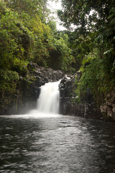
Nankepinmerepw River Valley
![]()
![]()
![]()
![]()
This route passes through the gorgeous valley of Nankepinmerepw, following the upper tributaries of the Nan Riohk Stream (Pilen Nan Riohk) and eventually arriving north of Nahnalaud on an arm of the major mountain system. One guide stated that the valley’s name refers to the mworopw tree (Inocarpus fagifer), also known as the Polynesian chestnut — though the spelling is clearly different. Nankepin means “in the bottom of”; the mworopw leaf has a deep trough in the middle where the primary vein bisects the blade, mirroring the way the stream bisects the deep, narrow valley.
The hike begins at a rutted turn-off from the well-graded (but unpaved) road to Pahn Sile Waterfall, leads to a metal footbridge over the Senipehn River (Pillapen Senipehn) — the only bridge like it on the island — and connects with a path on the far side. From there, the trail meanders northwest not far from the Nan Riohk and more or less parallel to it.
The first kilometer or so cuts through cultivated lands. Then it begins to follow the water more closely as it passes into the wilder riverine forests. There are at least nine major stream crossings in this next segment, some of which may be difficult or impossible if there has been a lot of recent rain. Above the last major Nan Riohk tributary, where the name of the stream changes to Nankepinmerepw, hikers take to the stream bed itself, which is certainly the most challenging aspect of the route (13% slope average). The algae-slimed rocks are slick and dangerous and hikers may find that they have to go very slow and use both hands to avoid disastrous slips; it would be easy to snap an ankle or shatter a kneecap in this place. Despite the rough terrain, the scenery in the hidden valley, often fenced on both sides by high rocky walls, is terrific. At times, the trail passes along the tops of vertical prismatic basalt columns.
The first few points of interest are beautiful pools that will tempt any overheated hiker — and why resist? A bit further is a small waterfall near an outcropping of prismatic basalt. Informants in the area say that this location was one of many where prismatic basalt columns were quarried for use in the building of Nan Madol. Abandoned prisms can be found lying in the stream bed in several places — the largest just below the falls. How exactly the massive prisms were hauled down to the coast over such distances and through such rough terrain is anyone’s guess.
After a short, steep section (22% slope average), the valley terminates at a huge “horsetail” waterfall that the route crosses above (you can scramble down the eastern slope without too much difficulty for a better view from the side). The shallow pools above the falls are an excellent place for a look at Pohnpei’s native crayfish. This is the turn-around point for day-hikers.
Past the big waterfall, the stream narrows until it reaches a third waterfall — this one short and wide, falling over a straight lip (usually called a “block falls” or “sheet falls”) — and then diminishes to a trickle. Those who wish to go further, will climb to the west (29% slope average) and then south again to follow the ridgeline (18% slope average) toward Nahnalaud.
- Please visit the Local Guides & Tour Operators page for a list of experienced guides available for hikes to Nankepinmerepw.