
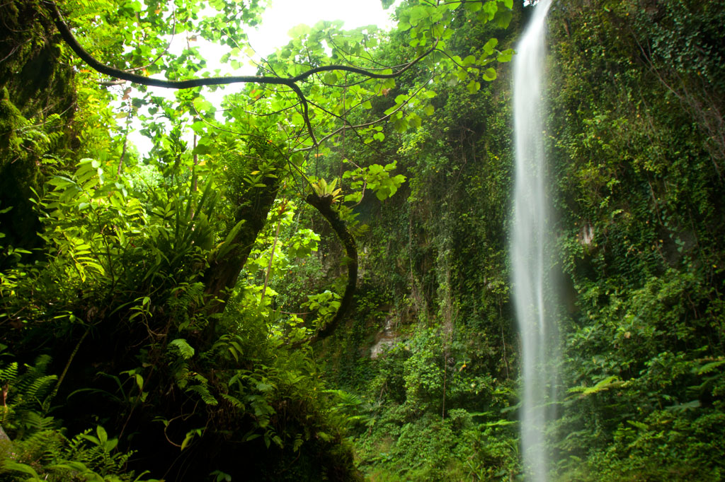
Nanpohnmweli Waterfall
")
![]()
![]()
![]()
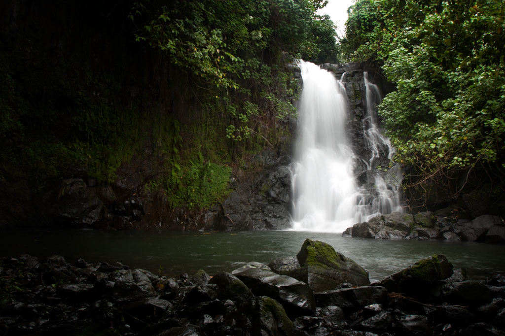
Though you can reach the top of Nanpohnmweli from Mand, the best way to access this falls (also known as “Kerenis” Waterfall) is from the Circle Island Road in Sapwehrek Kousapw. The walk begins at Benford Etse’s residence immediately south of the bridge and the sign for the Senipehn River Reserve and takes less than 10 minutes each way, following a well-trodden path that the family uses for planting sakau.
It’s hard not to be impressed by the place, even if you’ve already seen many of Pohnpei’s waterfalls. Like Kepirohi, the water tumbles over a gently sloping basalt wall rather than falling straight down over a cliff, but this falls is narrower.
[warning]Unfortunately, testing in April 2013 indicated that this site had 2.5 times more E. coli than is considered safe for swimming, so you’ll want to stay out of the water.[/warning]
The Etse family doesn’t charge an access fee to visit the falls, but since you’ll need someone to show you the way through their property, offer $5.00.
- Plan for 45 minutes round-trip with some time to admire the view of the falls.
Mand Area Attractions
![]()
![]()
![]()
![]()
![]()
Mand is a little community of Pingelapese people who were given a parcel of land by the Nahnmwarki of Madolenihmw in Pohnpei’s modern past. You can’t call it a town, but it feels more connected than many of the island’s Pohnpeian communities. In addition to the Pingelapese who live in Mand Proper, there’s a small village to the north inhabited by Kapingamarangi islanders, who settled in the area very recently (Kapingamarangi is a distant atoll that is culturally and linguistically Polynesian but politically a part of Pohnpei State). The center of Mand consists of the elementary school and church. Next to the church is a monument which lists the names of the first settlers from Pingelap Atoll — the founding members of the community.
Kokomaru Waterfall
Most local people outside of Mand have never heard of Kokomaru, which is strange, because it is a gorgeous spot and worth visiting. The route to the waterfall, which lies just downstream from the Mand community, begins at the end of an unpaved road next to the Latter-Day Saints (LDS) Church, passes through a plot of private land, and then cuts through the forest to the river. The trail tends to be overgrown, as the falls is rarely visited except by an odd kid or two from the community. Once at the riverbed, you can get a good look at the waterfall, which is similar visually to Liduduhniap. Some of the kids in the area will tell you that the rock behind the falls looks like a heart from certain angles (we didn’t see it). The cliff on the south side of the waterfall pool is the nesting site for a huge colony of Caroline Islands swiftlets which seem to fill the air when they leave their nests.
[warning]Despite Kokomaru’s charms, you can’t swim here — riverside pig pens in Mand have severely contaminated the stream. Testing in April 2013 indicated that the water below Piladad had five times more E. coli than is considered safe for swimming. Don’t be fooled by the clarity of the stream; this is sadly in the top ten most polluted watercourses on Pohnpei Island. Even the Mand kids don’t swim there.[/warning]
- Plan for 45 minutes round-trip for this excursion.
Piladad Pool
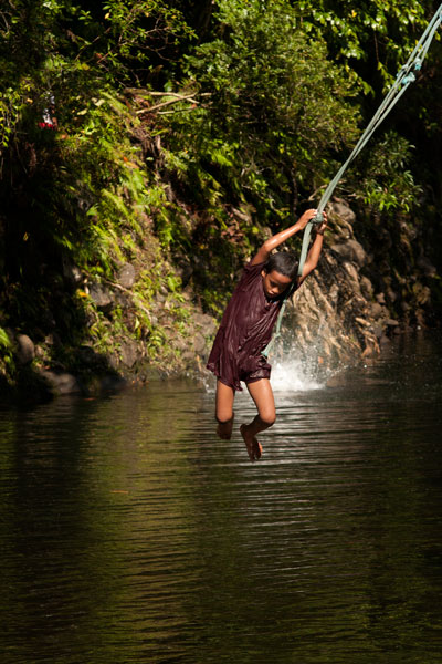
There is only one place you can safely swim in the Mand area and that’s at a sweet little pond known as Piladad, which lies up-stream from the last inhabited house and pigpen. The pool, which was once a gauging station for the watershed (the gauge apparatus is still there), is large and pristine with enough depth in the middle for the fun rope swing that dangles from an overhanging tree. There are also two small waterfalls. Piladad is a great place to go on hot days; the spot is close to the feet of the mountains and the water tends to be quite chilly. This also means there’s some potential for flash floods, so it would be wise to avoid the spot when rain clouds lie over the mountains. A narrow, but well-used, 0.4 km footpath to the pool begins on the south bank of the river next to Mand Elementary School. At the one branch in the path, bear toward the river.
Almost any kid you see in the area can guide you to either location. Offer $10 for a group of five or less.
- The hike takes about 10 minutes each way.
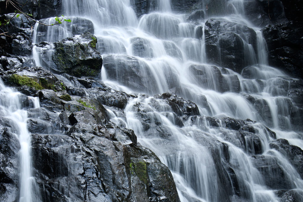
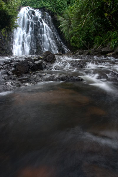
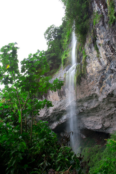
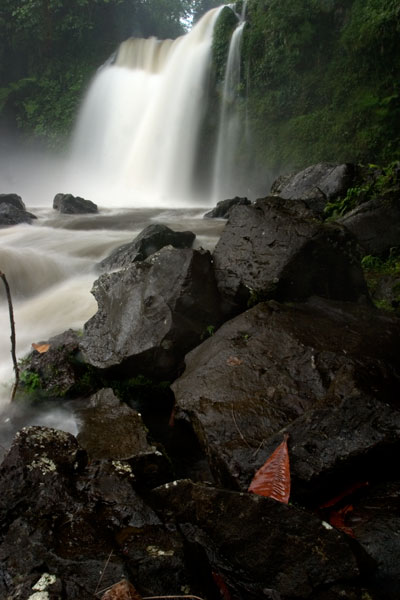
Nanpohnmweli (“Kerenis”) Waterfall
This very tall waterfall on the Sapwehrek stream can be reached by following the unpaved road 1.24 km (0.77 mi) north and east from Mand through a tidy Kapingamarangi settlement to the next stream over. The problem with visiting the falls from this access point, however, is that you end up at the top, where you can’t really see much. The rocks are treacherously slippery and there’s a long — certainly fatal — fall for anyone who makes a mistake. A local girl was killed when she fell from this spot a few years back. The nickname of the waterfall is derived from the Kapingamarangi pronunciation of the English word “Greenwich”, which is what sailors called Kapingamarangi Atoll during the whaling period. To visit this waterfall from the bottom, visit the Nanpohnmweli Waterfall page.
- This walk takes 15-20 minutes each way.
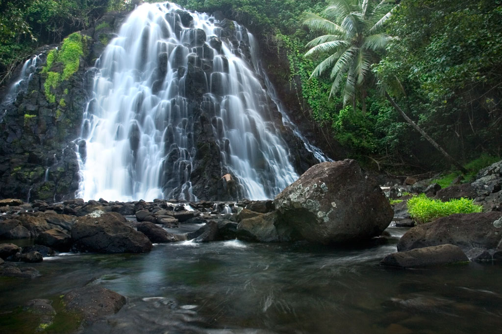
Kepirohi Waterfall
Kepirohi, which lies on the lower Mand Stream (Pilen Mand) in Kepirohi Kousapw, is certainly Pohnpei’s most famous and most photographed waterfall and makes a nice picnic stop after a visit to the ruins of Nan Madol just a few minutes away. Here a large volume of water (the most of any waterfall on Pohnpei) cascades over a wide, sloped pyramid of basalt rock and fills a shallow pool before running down toward the coast, giving the spot a singular look. A well-maintained — and in places rock-paved — path begins near Adalina Johnny’s residence and skirts the right side of the river to the falls. It’s an easy, level walk. Unfortunately, the landowners decided a few years back to construct an unsightly concrete viewing platform just to one side of the falls, detracting considerably from the aesthetic and natural appeal of the location.
There’s an old, weather-worn sign out on the Circle Island Road that marks the turn-off and limited parking on either side of the landowner’s driveway.
Visitors can pay the admission fee ($3 per adult and $1.50 per child) at Johnny’s house on the right or at the small store near the trailhead. No guide is needed for this hike.
- Plan for 1 hour for this hike.
[warning]As is true of many of the streams in this part of Madolenihmw, the water at Kepirohi is highly polluted by animal waste; visitors are advised not to swim.[/warning]
Nankepinmerepw River Valley
![]()
![]()
![]()
![]()
This route passes through the gorgeous valley of Nankepinmerepw, following the upper tributaries of the Nan Riohk Stream (Pilen Nan Riohk) and eventually arriving north of Nahnalaud on an arm of the major mountain system. One guide stated that the valley’s name refers to the mworopw tree (Inocarpus fagifer), also known as the Polynesian chestnut — though the spelling is clearly different. Nankepin means “in the bottom of”; the mworopw leaf has a deep trough in the middle where the primary vein bisects the blade, mirroring the way the stream bisects the deep, narrow valley.
The hike begins at a rutted turn-off from the well-graded (but unpaved) road to Pahn Sile Waterfall, leads to a metal footbridge over the Senipehn River (Pillapen Senipehn) — the only bridge like it on the island — and connects with a path on the far side. From there, the trail meanders northwest not far from the Nan Riohk and more or less parallel to it.
The first kilometer or so cuts through cultivated lands. Then it begins to follow the water more closely as it passes into the wilder riverine forests. There are at least nine major stream crossings in this next segment, some of which may be difficult or impossible if there has been a lot of recent rain. Above the last major Nan Riohk tributary, where the name of the stream changes to Nankepinmerepw, hikers take to the stream bed itself, which is certainly the most challenging aspect of the route (13% slope average). The algae-slimed rocks are slick and dangerous and hikers may find that they have to go very slow and use both hands to avoid disastrous slips; it would be easy to snap an ankle or shatter a kneecap in this place. Despite the rough terrain, the scenery in the hidden valley, often fenced on both sides by high rocky walls, is terrific. At times, the trail passes along the tops of vertical prismatic basalt columns.
The first few points of interest are beautiful pools that will tempt any overheated hiker — and why resist? A bit further is a small waterfall near an outcropping of prismatic basalt. Informants in the area say that this location was one of many where prismatic basalt columns were quarried for use in the building of Nan Madol. Abandoned prisms can be found lying in the stream bed in several places — the largest just below the falls. How exactly the massive prisms were hauled down to the coast over such distances and through such rough terrain is anyone’s guess.
After a short, steep section (22% slope average), the valley terminates at a huge “horsetail” waterfall that the route crosses above (you can scramble down the eastern slope without too much difficulty for a better view from the side). The shallow pools above the falls are an excellent place for a look at Pohnpei’s native crayfish. This is the turn-around point for day-hikers.
Past the big waterfall, the stream narrows until it reaches a third waterfall — this one short and wide, falling over a straight lip (usually called a “block falls” or “sheet falls”) — and then diminishes to a trickle. Those who wish to go further, will climb to the west (29% slope average) and then south again to follow the ridgeline (18% slope average) toward Nahnalaud.
- Please visit the Local Guides & Tour Operators page for a list of experienced guides available for hikes to Nankepinmerepw.
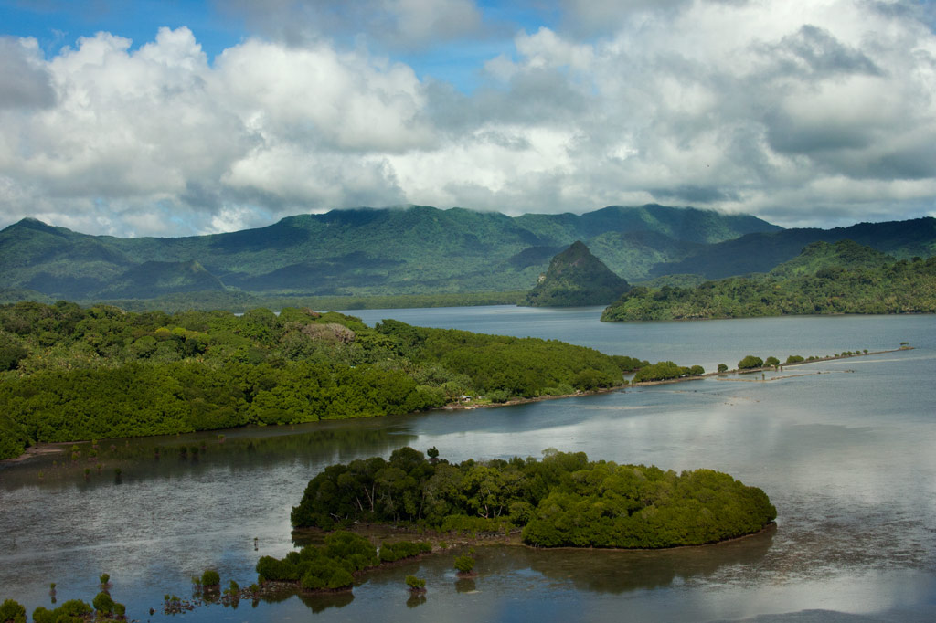
Madolenihmw Bay Area
![]()
![]()
![]()
![]()
![]()
![]()
![]()
![]()
![]()
![]()
![]()
![]()
![]()
![]()
![]()
Dauen Sapwalap / Senipehn Mangrove Reserve
- Visit the Paddling Around Madolenihmw page for a detailed description of this location and the adventures to be had in the area.
- Entering the mangrove reserve requires a permit. Visit our MPA page for details.
Kamau Pwoungapwoung
Though we didn’t map the hike to this destination as part of the eco-adventure map series (for lack of time), it would, never the less, be an exciting adventure to consider. Kamau Pwoungapwoung refers to a freshwater pool and waterfall at the headwaters of the Dipwilap Stream (Pilen Dipwilap), one of the tributaries of the Senipehn River (Pillapen Senipehn). The place is significant as the location where the last battle between the Saudeleur‘s warriors and Isokelekel’s men was fought. Upon being defeated by Isokelekel, the Saudeleur transformed himself into a small blue fish, that inhabits the pool to this day, and leaped into the waterfall. The hike would be a long one from the area around Pahn Sile. The closest access point would probably be from the direction of Nihpit fern meadow (reached from eastern Kitti).
- The absolute best choice for a guide is Relio Lengsi. Give him a call at +691.924.2580 and discuss the best route options and access points for this location. Offer $50.00 for a full-day hike.
Nanpahlap Peak
The 137 m (449 ft) hill to the east of Takaiuh looks as if its top has been lopped off — which fits in with the story about its creation (see Takaiuh below). Though steep in places and somewhat overgrown, the ascent isn’t too strenuous. At the summit are the tumbled ruins of a prehistoric stone structure and a breath-taking view. The whole area around the southern foot of the hill is criss-crossed with Japanese trenches and dotted with tunnels, including at least one very long one leading into the hill. The grid of paddies and irrigation canals where the Japanese successfully cultivated rice (despite Pohnpei’s challenging climate conditions) are found on both sides of the unpaved access road, though you can get closest to the bulk of these fields from another road to the west.
Everything is private land, but no official access fees are charged.
- To hire a guide, ask at the houses in the area or contact Hanke Albert at +691.320.4047. Offer $25.00 for Nanpahlap or a half-day of exploration in the area.
Nanwap Marine Protected Area (MPA)
Nanwap Marine Protected Area is a 3.05 km2 (305 hectare) section of the barrier reef and adjacent lagoon areas on the north side of Kepidauen Deleur (passage). The sanctuary was founded by community members from Metipw and Lukop and their respective chiefs and gained legal status in 2010. It became the first of Pohnpei’s MPAs to have its own formal community-created management plan with the support of the Pohnpei MPA Executive Management Network and the state offices of the Department of Land and Natural Resources, Division of Fish and Wildlife, Office of Fisheries and Aquaculture, and Environmental Protection Agency. Nanwap is a “no-take zone,” which means no fishing or gathering of any kind is allowed within the boundaries. It is regarded as the “most biologically diverse and best preserved spawning and aggregation site” for many of Pohnpei’s core reef fish species. Snorkelers should seek out the protected blue holes on the west side of the reef, while SCUBA divers will want to do a drift dive on the southern wall of the reef during an in-coming tide.
- Entering the MPA requires a permit. Visit our MPA page for details.
Pahn Dieinuh
- Visit the Paddling Around Madolenihmw page for a detailed description of this location.
Peiai
Peiai is a small populated place near the turn-off for Pahn Sile waterfall. During the battle between the warriors of Isokelekel and the army of the last Saudeleur, Peiai was the place where the tide of battle turned dramatically (hence, the name references a situation where the runner-up in a race pulls ahead of the leader — loosely translated “the battle is reversed”). Isokelekel’s men were being beaten down by the forces of Nan Madol when one of the conqueror’s greatest fighting men pinned his own foot to the ground with his spear, refusing to retreat and declaring that he would kill any man who tried to run away from the fight. Isokelekel’s men rallied behind this show of bravery and pushed back the Saudeleur‘s warriors, chasing them up the Senipehn River and eventually to Kamau Pwoungapwoung, a waterfall at the headwaters of the Dipwilap Stream, where the Saudeleur was finally defeated.
Sapwalap
Sapwalap (“large land”) is an expansive region of mostly flat ground that makes up a sizable chunk of central Madolenihmw. The Japanese recognized Sapwalap‘s potential as a site of large-scale agriculture. During the thirty years leading up to World War II, sugarcane was cultivated and processed at a facility near Kitamw (the tower is still partly visible in the jungle off the road) and rice was grown in a patchwork of paddies fed by irrigation canals. Strangely, no one is growing rice these days, but the paddies are still there opposite the gleaming LDS Church. Other fields are found as far east as Lukop.

Tahio
Tahio, on the south side of Nanpahlap, is another place where the Japanese were active. The access road was built by them and the coastal area is full of trenches, rifle pits, dugouts, and tunnels. Everything is overgrown, but anyone who pokes around will be rewarded with interesting finds. Bring a local resident along.
Takaiuh Peak
You can’t visit Madolenihmw without being arrested by the sight of Takaiuh, a 160 m (525 ft) peak shaped like a traffic cone that stands on the north side of the bay and seems to guard the entrance to the Sapwalap estuary. The mythical origin-story of the hill — which bears a striking resemblance to the Biblical tale of the tower of Babel — involves Mwohnmur and Sarapwau, two wily brothers who enter into many Pohnpeian legends (they also created the Sahwar Valley and the rock of Pohnpaip).
How Takaiuh Came to Be
Long ago, two boys named Mwohnmur and Sarapwau were born in Salapwuk (Kitti) to a woman named Lienlama. The boys were always involved in clever schemes and mischief and traveled far and wide doing great works. Once, the brothers took a piece of stone, and using it like a canoe, paddled to Pohndolen Imwinsapw near what is now Tahio in Madolenihmw. There, Mwohnmur and Sarapwau amused themselves by piling up rocks until they had formed a large hill. A local demi-god named Lapongo saw what they were doing and wasn’t pleased, so he threw a stone at their hill and destroyed it. He then challenged the brothers to a competition to see who could build a mountain the fastest. The three set to work, but it soon became apparent that the boys were winning. Their mountain was so tall it had reached the sky. Being a poor loser, Lapongo became enraged. He picked up a stone and threw it at the new mountain, which broke into six pieces. The base of the mountain that remained standing was named Takaiuh (“standing stone”).
This was not the end of the conflicts between the brothers and Lapongo, however. Lapongo mocked and ridiculed the boys whenever he could, and they did not like it. Now, the brothers liked to play at a place called Pahnlikes, below the spot where they had settled on Likes peak west of modern-day Sapwalap. There was a steep slope there that they would slide down for fun, sitting upon the leaf sheaths of the kotop palm (Clinostigma ponapensis). The boys knew that Lapongo had been watching them and was aware of their play place, so they decided to trick him. Lapongo was invited to slide down the slope with the boys, but they chose a spot where the slope ended at the waterside (possibly the southern tributary of Pilen Kitamw). All three began sliding down the hill. When Mwohnmur and Sarapwau reached the bottom, they leaped off their sheaths and dived to safety, but Lapongo went straight and fell into the water. He sank down into the depths, and the brothers threw rocks on top of him to keep him from resurfacing.
Takaiuh is actually an island separated from the coast by a strip of mangrove forest. It was once inhabited, but is no longer. Though the hill is climbable, the ascent is extremely dangerous, characterized by very steep slopes and cliffs prone to rockslides with little or nothing solid to hold on to. For this reason we strongly advise visitors to enjoy Takaiuh from below rather than trying for the summit. Hikers who insist on seeking the summit, do so at their own risk. Distant views of the peak are found along the Circle Island Road, but the best close-up view from land is from the old Japanese road in Kepine. According to residents living in the area, the Japanese abandoned an attempt to build a trail all the way to the top of the hill. Some of the low wall can still be seen on the lower slope.
Pahnsapw & Nankep Waterfalls
![]()
![]()
![]()
![]()
![]()
")
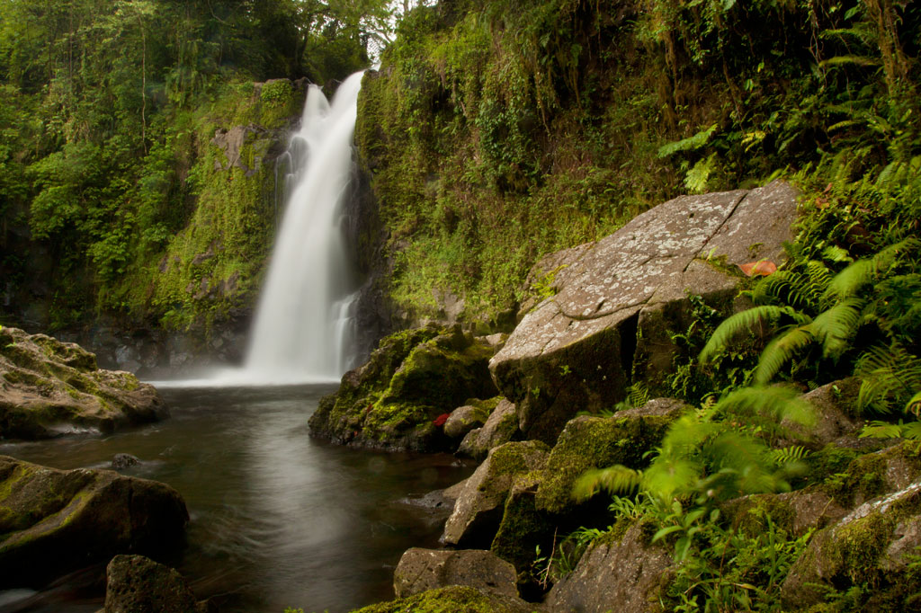
Pahnsapw, which means “beneath the land,” refers to a pair of tall, majestic waterfalls which plummet off the edge of a high plateau in central Madolenihmw (it’s also the name of the farmstead). Both waterfalls are found on the land of the Silbanuz family (relatives of the people at the Nan Madol trailhead) — the smaller falls is lower down and hidden from view until you get up-stream, but the upper falls can be seen from the Circle Island Road.
The hike starts at the end of an unpaved road and criss-crosses the stream or runs along the bank up to the first falls, which is about 4 to 6 meters (13-20 ft) high and has a beautiful shallow pool at the base, excellent for a quick, cool swim. Unless you’re in good physical condition and don’t mind getting dirty, this is where you should stop.
")
To reach the second falls, the route climbs straight up an extremely steep (and sometimes muddy) slope to the right of the lower waterfall with little to hold on to, turns horizontally across the slope face, and then returns to the river, where there’s a secluded pool in a shady nook. It might be a good idea to bring a length of rope and have the guide secure it to something at the top of the slope prior to scrambling up. Five minutes up-stream is the second waterfall, which is about 18 meters (60 ft) tall and falls into a large, deep pool. The water at both waterfalls is cool and very clean.
The Silbanuz family charges an access fee of $2.00 per person. Any of the teenagers around the house can be hired as guides. Offer $12.00.
- Plan for 2 hours round-trip with some leisure time at both of the waterfall pools.
Nankep Waterfall
The next waterfall going south is known as Nankep. People living in the area say the name means “inlet” or “in the cup” (depending on who you talk to). The latter seems logical, except that the Pohnpeian word kep is a loaner from English and wouldn’t date back beyond the early 1800s. The site may have had a different name prior to that time or it has picked up new meaning over the years. The road to this trailhead is steeper and more rutted than the one to Pahnsapw, so it’s best to park at the bottom near the Circle Island Road and walk to the end, where the trail begins on Waltis Herdinand’s land — an area referred to as Elilpei. The hike is short and relatively easy, concluding in a hidden nook with a small plunge pool. The best time to visit Nankep is after a period of heavy rain as it can be nothing more than a tiny ribbon of water at other times. Some people believe that the falls will be dry if all the members of the visiting group are male, so mix it up.
No official access fee is charged.
- Plan for 90 minutes round-trip with time to swim at the falls.
- To hire a guide, ask at the houses in the area, contact Hanke Albert at +691.320.4047, or call the owner of the land around the falls, Waltis Herdinand, at +691.320.2909. Offer $12.00.
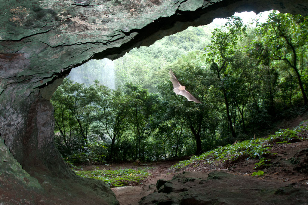
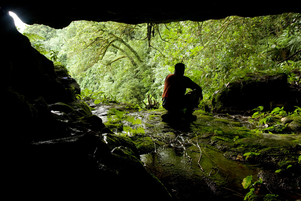
Pahntakai Cave & Waterfall
![]()
![]()
![]()
![]()
![]()
![]()
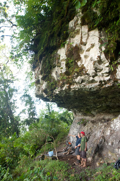
Pahntakai literally means “under the rock” and one visit makes it immediately apparent why this geologically-unique location was given its name. A thin waterfall plummets over a concave cliff-wall more than 30 meters high, which shelters a wide strip of mostly flat ground. You can walk all the way across beneath the cliff to where the ledge widens even more and a small, rocky hill rises up north of the waterfall. Yawning caverns behind the falls host colonies of small insect-eating bats and Caroline Islands Swiftlets that hurry out at dusk to hunt for insects. If you want a closer look, you can climb up through the mounds of guano to the cave openings.
The waterfall itself varies greatly in volume, depending on rain, crashing onto jumbles of rocks below the ledge. It is possible to climb down the slope and stand under the water, but the rocks are slippery and dangerous and there is no pool.
The trail is found at the end of the road and is well-maintained and fairly level most of the way to the cave, skirted by several varieties of sakau (kava) and affording stunning views of the deep gorge below the falls, small huts on the steep hillsides, and the blue sea far out beyond the green of the island. Though you do not need a guide or any special permission to do this hike, the site is private property and the family at the last house on the road charges an entry fee of $3.00 per visitor. Make sure you bear left at the trailhead, rather than taking the path to the right which goes steeply downhill and eventually leads to a house. The hike takes a leisurely 40 minutes round-trip, but Pahntakai is so magical you’ll probably want to hang around and soak up the atmosphere.
Camping
The landowner, Pedro Marvis, permits visitors to camp overnight at Pahntakai, provided they are quiet and respectful of the place and take all their garbage with them afterward. The price per person is the same as when making a day visit — $3.00. The best place to camp is at the northwest end of the trail, where the strip of ground under the cliff is wide and flat. There’s a rock fire-pit there and sometimes some dry firewood left lying around. Because of the overhanging nature of the cliff, things stay dry even during heavy rain. There is one small stream that crosses the main trail about half-way from the trailhead — a good place to filter drinking water if you’re going to stay at Pahntakai a while.
Nan Kiepw & Na Malek
Nan Kiepw
![]()
![]()
![]()
![]()
![]()
Nan Kiepw
Nan Kiepw, which means “in the lilies,” is a hillside overshadowed by Dolmweir peak. A Pohnpeian myth tells of a Yapese magician, named Sou Iap, who voyaged to Pohnpei and was responsible for the creation of Sokehs Rock). One of Sou Iap‘s companions, Souliken And, noticed a girl collecting clams on a reef north of Sokehs Island, and thinking her very attractive, chased her deep into Nett, carrying an ihd leaf with him. On the hillside below Dolmweir peak, Souliken And lost his leaf and named the place after a species of white lily he saw there.
During the Sokehs Rebellion in 1910, Pohnpeian rebels fleeing from German and Melanesian troops briefly took refuge at Nan Kiepw, rebuilding some earthen fortifications from the Spanish Period and repelling a small attack.
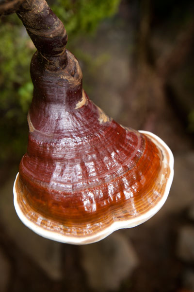
Today, Nan Kiepw maintains a pristine beauty that betrays no sign of past violence. A tributary of the Nanipil River (Pillapen Nanipil) runs through the area, forming a wide gentle cascade, some small pools (though none big enough for swimming), and a “horsetail” waterfall before winding into the valley. Upstream is a basalt outcropping — really a great boulder — that forms an overhang where a few people can comfortably camp out of wind and rain. Huge ivory nut trees, red sandlewood, and a variety of hardwoods dominate the lush native forest, and there are many unusual varieties of fungi to be seen.
The Origin of the Ivory Nut Palm
On the fourth voyage to Pohnpei after its founding, a man came named Mederiap, bringing with him the ivory nut palm and propagating it on the island. Prior to this time people had mostly lived in caves, because they had nothing to use for roofing material, but ever afterward, the fronds of the ivory nut palm were woven together to produce roof thatch for houses.
The moderately challenging trail begins behind a house near the Nett hydroelectic building at the end of the Nanipil River Road (the same trailhead for Nahnalaud). Hikers cross the Nanipil River directly and walk along a well-maintained footpath for 0.99 km / 0.61 mi (5% slope avg) before coming to the first major branch. The left (east) branch leads on toward Nahnalaud, while the right (west) branch heads to Nan Kiepw. From this point it’s 1.4 km / 0.87 mi (14% slope avg) to the last residence along the trail at 265 meters of elevation, and then another 1.8 km (1.12 mi) to the waterfall. This last segment has two little ascents with slope averages of about 20% and 26% and a more moderate bit in between (11% slope avg). Sakau (kava) plantations are found on both sides of the trail much of the way. Hikers should take care to avoid damaging these valuable plants.
[info], Pohnpei, Federated States of Micronesia (FSM)")
Crab’s Eye Vs. Red Sandlewood: What to Know and Why it Matters
Two species of trees found both in inhabited areas and in the upland forests of Pohnpei produce small brilliant red seeds about the size of popcorn kernels. These can be seen scattered across the forest floor and often on the trail leading to Nan Kiepw. Red seeds with a single black dot on them belong to Abrus precatorius (Crab’s Eye Seed or John Crow Bead), while solid red seeds come from Adenanthera pavonina (Red sandlewood). The first type of seed (with the black dot) contains a compound, called abrin, that is 75 times more toxic than ricin and can be fatal if ingested; the fatal dose is about 0.1 mg for an adult of roughly 68 kg (150 lbs). Symptoms of poisoning include nausea, vomiting, convulsions, liver failure, and death after several days. The second type of seed (all red) is harmless when cooked and is sometimes eaten as a snack by Pohnpeian children. Strangely, the same Pohnpeian name — kaikes — is used to identify the two species of trees. Both Abrus precatorius and Adenanthera pavonina originate on the Indian subcontinent. Seeds are sometimes used to make necklaces and other jewelry.[/info]
Na Malek
Na Malek (“his chickens”) is a rock overhang and cave — located in the part of upland Nett once known as Nansokele — said in myth to have been the home of the demon Taimuan. The site, which has excellent views of the valley, Dolen Eirike, and Dol Rakied, is reached via a steep loop of path (0.61 km / 0.38 mi with a 42% slope average) that branches off from the Nan Kiepw trail. The overhang is large enough to provide a protected camping spot, and the elevated cave is bone-dry, flat-floored, and suitable for sleeping. Water running off the rock can be filtered for drinking. This is a relaxing and beautiful place to watch birds, including the Grey White-eye and rare Long-billed White-eye.
- Plan for 8 hours for both Nan Kiepw and Na Malek.
- Please visit the Local Guides & Tour Operators page for a list of experienced guides available for hikes to Nan Kiepw. Offer $50.00 for a group of five or less.
The Tale of Taimuan
A well-known Pohnpeian myth states that Na Malek was the the home of a hideous old demon, named Taimuan, and his sister, Litapinmalekelek. Taimuan had a hankering for human flesh and was, in particular, interested in the beautiful daughter of the Saudeleur — the supreme ruler that reigned from Nan Madol. Deciding that he wished to devour the girl, Taimuan set out for Nan Madol, transforming himself into a handsome young man along the way and leaving his old parts at different points in the mangroves — his white hair, swollen legs, swollen testicles, sagging eyelids, etc. When Taimuan arrived at Nan Madol and presented himself to the Saudeleur, both the girl — who was called Kisin Ntamwahu (“a little bit of good blood”) — and her father were impressed with the young suitor. Kisin Ntamwahu fell for Taimuan and begged her father to let them marry. Soon the two were married and given a home on Pahn Kadira.
After residing at Pahn Kadira for a while, however, Taimuan obtained permission from the Saudeleur to take Kisin Ntamwahu back to Na Malek. On the way, he picked up all his old parts from the mangroves and was restored to his prior appearance. Kisin Ntamwahu realized she had been tricked, but Taimuan carried her away against her will and confined the girl inside the cave at Na Malek. Then he climbed to the top of the mountains to invite all the other demons in the area to join him in feasting on the girl. While he was away, his sister, Litapinmalekelek, discovered Kisin Ntamwahu and felt sorry for her. She began to dig the girl out of her prison and encouraged Kisin Ntamwahu to turn herself into an ant, in order to escape, and flee into the forest. She warned the girl not to pass any plants without greeting them politely. As Kisin Ntamwahu ran, she greeted all the plants, big and small. All except one. Feeling a sudden need to urinate, she relieved herself in the forest and didn’t realize she’d done so on a plant called kampanial.
When Taimuan found that Kisin Ntamwahu was gone, he confronted Litapinmalekelek, but she claimed to know nothing. In a rage, Taimuan showered his sister with obscenities (specifically, he shouted, “Your vagina! My penis!” — a highly offensive reference to an act of incest) and then took off into the forest to catch Kisin Ntamwahu. He questioned each plant he passed, but none would tell him anything until he came upon the kampanial, which told Taimuan which way Kisin Ntamwahu had gone. Shortly thereafter, Taimuan met two worms on the path. He asked them where the girl had gone and they promised they would tell him if he pulled down his eyelids. He did so, and the worms threw dirt in his eyes. When Taimuan tried to wash his eyes out in a nearby streamlet, the worms muddied the water upstream, causing him to go blind and eventually die.
- Please visit the Local Guides & Tour Operators page for a list of experienced guides available for hikes to Nan Kiepw.
Lou Rahn Cave & Waterfall
![]()
![]()
![]()
![]()
![]()
![]()
Tucked away in the little-seen Nett hinterlands is one of Pohnpei’s most beautiful hiking destinations. Uluhlen Lou Rahn, a fence-like ridge, extends northwest from the place where the mountains of U meet those of Nett, hiding from view the verdant valley of the Pwong Stream (Pilen Pwong). Cutting through this gorge from its source below Dolen Nahnsapwe, the stream spills over a high cliff to form a thundering waterfall next to a large cave with a view of the misty valley floor. Though there is no quick way down to the bottom of the waterfall from the cave (you can backtrack a ways and make your way down the slope to the stream), there is a gorgeous pool for swimming just up-stream with cool, crystal-clear water.
 at Lou Rahn, Pohnpei, Federated States of Micronesia (FSM)")
The trail to the site begins off the unpaved but well-graded road in Paremkep and sees plenty of traffic from sakau farmers and residents on the first 0.6 km (0.37 mi) leading toward the spur (12% slope avg). Once it reaches the ridge, it cuts east and passes along Lou Rahn’s inside slope rather than following the ridgeline (0.92 km / 0.57 mi, 19% slope avg). The hardest aspect of this full-day hike is the treacherous footing, as much of the last leg of the route crosses the sharp, jumbled rocks of old landslides now obscured by high grass. Take care and watch each step; a fall into one of the hidden crevices could result in a serious sprain or fracture — not a good thing to have way out in the forest on Pohnpei. There are also a great many sakau (kava) plants in the area — a massive number, in fact — which hikers must take care to avoid damaging. The roots of the plant are used to make Pohnpei’s potent ceremonial drink. Large plants can be twenty years old or more. Small huts, which farmers use while working on their plants, are passed at several places along the route.
The cave sits just to one side of the falls with a stunning view of the hidden valley. The roof is a bit low in places, but it’s quite a fair size none the less. Though a thin stream of water flows across one side of the cave floor, the rest is dry and makes an excellent camping location. Hunters often use it, and you may notice their cooking pots stored in crevices at the rear of the cave.
- Plan for 6-8 hours for this hike.
- Please visit the Local Guides & Tour Operators page for a list of experienced guides available for hikes to Lou Rahn. Offer $37-50.00 for a group of five or less.
Liduduhniap Waterfall, Nanipil & Nan Madap Attractions
![]()
![]()
![]()
![]()
![]()
![]()
![]()
Liduduhniap Waterfalls
The easiest waterfalls to visit on Pohnpei (no hiking required) are the tiered “horse-tail” falls, Liduhduhniap, just a few kilometers from Kolonia. When the Greater Nett Eco-Adventure Guide was published in 2015, we wrote of Liduduhniap:
“Some might consider accessibility to be a red flag and assume that a location so close to town would be completely spoiled by a constant flow of visitors and thoughtless development. That’s not the case here.”
Unfortunately, things have changed recently (2017). Under the direction of Pohnpei’s new tourism department, the landowners at Liduduhniap have chosen to severely undermine the natural integrity of the site by replacing the dirt path to the lower falls with an unsightly series of concrete steps and a concrete hut near the edge of the pool. Toilets have also been built on the site. For those of us who knew the place before this “development”, it will never be quite the same again, but Liduduhniap is still a beautiful spot — not just the two waterfalls themselves, but the greater area, which is lush, rugged, and often partially enshrouded in thick mists that drift down from the steep mountains. The population around the site is relatively sparse, and it is hoped that most of the land will remain as it has for decades — green and wild.
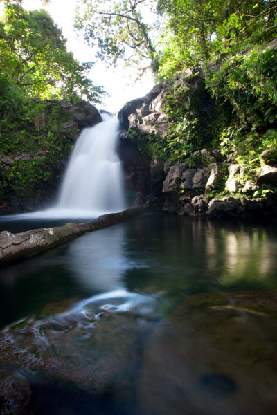
The Liduduhniap Waterfalls lie on a portion of the Nanipil River (Pillapen Nanipil) located right at the feet of the mountains and fed by a great deal of rain (the primary dam and reservoir that supplies the town with water is just a bit upstream). The upper falls cascades 4 meters (13 ft) into a deep basalt plunge pool with a jaw-dropping elevated view of the river valley and the slopes of the mountains. From there it spills over the lip and plummets another 8 meters or so (26 ft) into a larger, but shallower pool. Swimming is excellent at both pools, though the first is more difficult to get in and out of. Most people simply opt to take a flying leap off the rocks, but you can also carefully cross the river above the falls and climb down to the pool from the far side without too much trouble (go barefoot or wear five-fingers to avoid losing your flip-flops in the swampy sections). The water is crystal clear — except immediately after heavy rains — and always on the chilly side, making it a great escape for oppressively hot and humid Pohnpei days. The deep, narrow valley funnels air along so that there’s always a bit of a breeze, too, which keeps the ferns waving hypnotically and the temps down. No one is quite sure how deep the upper pool is, but it’s deep — deeper than you’ll ever sink after a jump. However, one must still take care to scan the water before leaping; flash floods sometimes wash tree trunks and other debris down from the mountains and these can become wedged in the pool below the surface. Depending on how high the river is, you may be able to swim up and get behind the falls, where there’s a small depression in the rock. There’s also a large cavern on the eastern side of the pool. The lower pool is too shallow for jumping.
The well-manicured and landscaped gravel trail to the site begins left of a large nahs (community hut) near the unpaved road and opposite the landowners’ house, meandering past blossoming hibiscus shrubs, plumeria trees, and ginger until it reaches a couple of ramshackle huts above the river. These make nice spots for a picnic lunch, while in the evenings the family uses them for pounding and drinking Pohnpei’s dizzying ceremonial drink, sakau (kava). Turn right by the huts and scramble down to the river to visit the upper falls. Note the mortar holes on the north side of the pool rim, where sakau was pounded in ancient times. To reach the lower pool and waterfall, continue along the main trail and down a series of concrete steps. The family charges an access fee of $1.00 per person to visit the falls. Occasionally they may ask you for $5.00 if it looks like you plan to take a lot of photos of the site.
[warning]Be advised that there have been many injuries and several fatalities at Liduduhniap! The spot is extremely prone to flash floods. In 1999, two Pohnpeians were swept away by a flash flood and carried over both falls to their deaths. In 2002, three visiting Palauan athletes were also killed by a flash flood; there’s a monument to them next to the trailhead. Danger from slips and falls is another issue. In 2012, an American educational volunteer fell to her death from the upper falls, which prompted the landowners to install a dodgy rope ladder on one side of the upper pool. Read the Safety Considerations in the right column and BE CAREFUL.[/warning]
- Plan for 30 min – 2 hours to enjoy the waterfalls.
Upper Nanipil Bird Walk
If you continue up the road from Liduduhniap, you’ll soon pass the dam and reservoir on the left. Just beyond this, also on the left, a footpath leads into the forest and runs through the woods above the stream for 1.1 km (0.68 mi). Among birders, this scenic walk is second only to Sokehs Mountain in terms of the variety and prevalence of species that can be seen. It’s easy to get to and doesn’t require any huffing and puffing, and the forests are rich and unspoiled and full of birds. There are no houses along the trail, which means that traffic and noise are at a minimum. You can see many species on the walk, but highlights include the Pohnpei Cicadabird (Coracina insperata), Pohnpei Fantail (Rhipidura kubaryi), Pohnpei Flycatcher (Myiagra pluto), and Crimson-Crowned Fruit Dove (Ptilinopus porphyraceus). We suggest you hire a local birding guide and bring a pair of binoculars. Stick to the path to avoid damaging this pristine watershed.
- Plan for 2-3 hours for this walk.
- Visit our Birding page to learn how to find birding guides.
Sengnaip Waterfall
This little-known two-tiered waterfall is located about 400 m (0.25 mi) south of the Nanipil Bird Walk described above. If you cut off the path and continue down the slope for about 170 m (186 yd), you’ll hit the main stream, which you can follow up for another 144 m (157 yd). At this point, you reach a large basalt pool that narrows on the far side and disappears into a rocky slot. You can get a great view and wonderful pictures of the falls from the rocks on the east side of the pool, but there’s no easy way to go further without swimming. If you do the latter, you’ll end up in a small plunge pool enclosed on three sides by high rock walls. There’s a cave just above the water level on the east side. The spot is unbelievably peaceful and has been seen by very few people. Treat it with utmost respect.
[warning]Like Liduduhniap downstream, this location has extreme flash flood potential. Read the Safety Considerations in the right column.[/warning]
- Plan for 2-3 hours for this excursion.
- Visit our Guides & Tour Operators page for a list of guides who can be hired for this hike.
Likei & Pahn Pwet Waterfalls
If you hire a knowledgeable guide and continue hiking south at the conclusion of the Nanipil Bird Walk (where the trail crosses a stream on a large log), you’ll soon strike the main river again. The route stays with the watercourse for 1.5 km (0.93 mi) with very gentle elevation gain (4% slope avg). At the end of this segment, the river is joined by another stream coming from the southeast. Following either course for about a third of a kilometer will lead you to a waterfall. The western route continues 0.37 km (0.23 mi) up a slope, where the hike steepens to about a 25% slope average before coming to Likei Waterfall. The eastern course leads 0.23 km (0.14 mi) with a 18% slope average to Pahn Pwet Waterfall. The two waterfalls are quite dramatic and little-known both by visitors and by local people. This area, called Nan Madap, is actually disputed territory; both Sokehs and Kitti claim it, though the municipal boundaries as they are typically drawn seem to place the location within Sokehs.
- Plan for 5-7 hours for this hike.
- Visit our Guides & Tour Operators page for a list of guides who can be hired for this hike.
Nan Kiepw Waterfall
Also with a local guide, a third falls can be accessed from a completely different route, beginning just west of the community hut by the Liduduhniap trailhead. This hike climbs up the mountain slopes fairly steadily for 3 km (1.86 mi). The first two thirds of the distance is relatively easy with a slope average of about 12%, but then the slope steepens considerably to about 41%. Nan Kiepw Waterfall is high up at about 500 meters of elevation (it may be one of the highest falls on the island), just below the summit of Dolen Nanikep and off the east side of the trail. Sometimes you can see this falls from the lagoon after heavy rain.
Serious trekkers have the option of continuing past the waterfall, up to Dolen Kiepw (610 m), and on to Dolmweir (735 m), where a thatched shelter was built for hikers in 2013 (note that the roof of the hut was already deteriorating when we visited only six months or so after it was constructed). This is an admittedly tough hike with slopes ranging from 25% to 40% and very rough terrain. The shelter is 1.5 km (0.93 mi) beyond Nan Kiepw falls. From the shelter, trails run west to Pekenuht (705 m) and down into Pehleng or east to Nahnalaud (772 m).
- Plan for 5-7 hours for this hike.
- Visit our Guides & Tour Operators page for a list of guides who can be hired for this hike.
Nanipil River Swimming Holes
“Cable Bridge Hole”
This is by far the most popular swimming spot on the Nanipil River located 4 km (2.5 mi) from downtown Kolonia, where the watercourse turns sharply away from the Nanipil River Road and forms two deep, placid pools. There used to be a cable footbridge that crossed this portion of the stream, but now all that remains are a couple rusting cables strung high above the water. The water at the site is clean and quite cool — an excellent place to freshen up on a sweltering afternoon. Avoid the site, however, during or immediately after heavy rain, as the water gets muddy from all the sediment washing into the valley upstream. Cars can be parked on the opposite side of the road.
“The Swimming Pond”
This is a favorite with young kids in the area, located 5.3 km (3.3 mi) from downtown Kolonia. A short walk from the Nanipil River Road leads to a long, deep pool with a steep slope on the far bank. Rope swings are often strung up on both sides of the pool, and there are some grassy spots to picnic and a tiny hut or two. The landowners, who live in a house on the side of the road opposite the trailhead, charge visitors $1.00 per person.
[warning]Flash floods are an issue at both sites, due to Nanipil Valley’s narrowness and the volume of rain that can fall in a short period of time in the steep mountains to the rear. Be wary.[/warning]